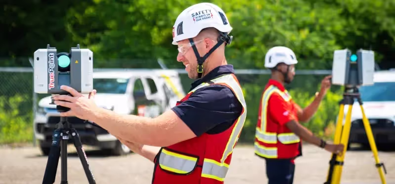
3D Laser Scanning
GPRS offers construction-grade 3D laser scanning services to deliver 2-6mm accurate as-built documentation for any building, facility, or site – regardless of age, size, or location within the United States. Using advanced LiDAR (Light Detection and Ranging) technology, our scanners capture millions of precise measurements, generating detailed point cloud files that form the basis for 2D CAD drawings, 3D models, and BIM deliverables. 3D laser scanning captures exact site dimensions and offers a cost-effective solution for as-built drawings and facility data.

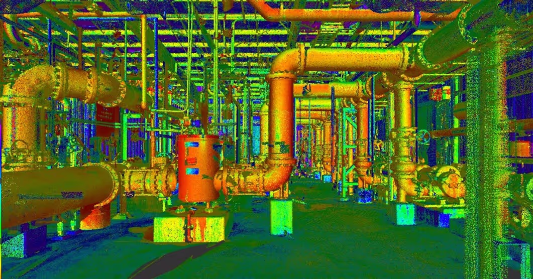
Point Clouds
Point cloud data is the outcome of 3D laser scanning, which captures precise spatial information of your site, building, or terrain using LiDAR technology, recording X, Y, and Z coordinates for every visible surface. GPRS Project Managers leverage advanced Leica 3D laser scanners to capture this data with millimeter accuracy, which can then be imported into CAD or BIM software for detailed analysis and modification. CAD engineers may prefer to work directly with the point cloud for their design needs without additional processing.

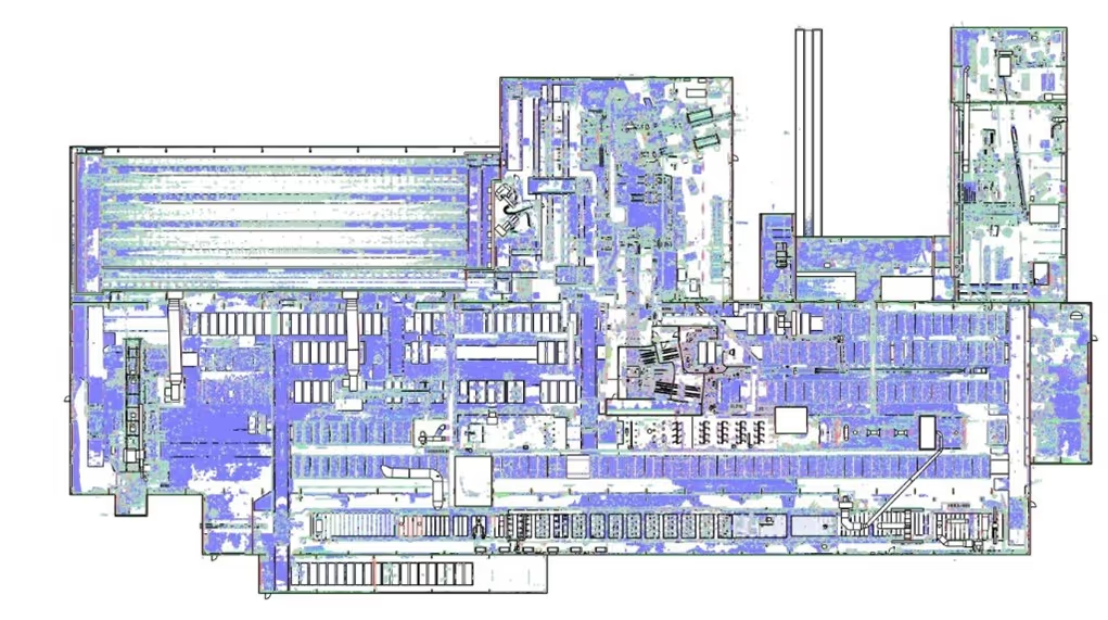
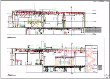
2D CAD Drawings
The GPRS Mapping and Modeling Team transforms your point cloud data into highly accurate 2D CAD drawings using advanced CAD software. They can also develop detailed 3D models in BIM software and extract precise 2D views by slicing through the model.Deliverables include site plans, floor plans, elevations, sections, details, isometric views, and reflected ceiling plans – essential tools for your construction planning, renovations, and building modifications. We can work within your template and standards, so that our as-builts are as useful and turnkey for you as possible.
.webp)
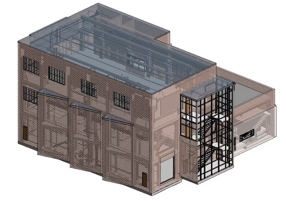
3D BIM Models
Building Information Modeling (BIM) is an intelligent, collaborative process that integrates point cloud data and 3D modeling to support the design, construction, and operation of a building throughout its entire life cycle. By combining scan-to-BIM technology with detailed material, cost, and spatial data, GPRS empowers your project team to Intelligently Visualize The Built World® to provide field to finish solutions – from project inception through facility management.

3D Photogrammetry
Photogrammetry uses a 3D camera – optionally equipped with LiDAR, to digitally document buildings, facilities, and sites through high-resolution imagery. 4K HDR photographs are taken from multiple positions and angles using tripod-mounted, wearable, drone-mounted, or crane-mounted systems to generate a complete 360° view of your site. This process saves time compared to traditional ground surveys and expedites decision making.
.webp)
Drone Surveys
GPRS Drone Survey Service delivers high-resolution imagery, video, mapping, and 3D modeling to support accurate and comprehensive visualization of the built environment.Utilizing FAA-licensed drone pilots, our team ensures safe, compliant, and efficient data capture across large-scale, hazardous, or hard-to-access sites. High-definition (HD) color image resolutions allow for accurate identification of anomalies at both small and large scales within your project.
.webp)
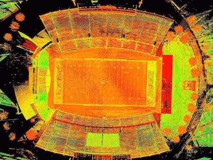
Ortho-Mosaic Imagery
An ortho-mosaic image is generated by processing drone-captured imagery through photogrammetry and orthorectification, producing a single, georeferenced image that corrects geometric distortions and applies color correction and balancing to deliver a cohesive and accurate visual dataset, enabling more informed decision making and streamlined planning.

3D Mesh
The GPRS Mapping & Modeling team can generate a 3D mesh in fbx, .stl, .obj, and .ply file formats directly from a LiDAR point cloud, enabling you to work with complex geometries in a CAD environment without navigating a point cloud. These meshes are ideal for repairing or restoring scanned elements with fine, organic details that are otherwise challenging to reproduce using traditional CAD modeling techniques. 3D meshes are valuable in historic preservation, preserving sculptures, creating digital replicas of trees, and much more.
.webp)
Virtual Tours
WalkThru 3D, delivered via SiteMap® (patent pending), gives you remote access to high-resolution reality capture with in-image measurement tools to support your planning and coordination efforts.PRO CAP Progressive Capture provides scheduled, 3D virtual tours that accurately document your site’s construction progress, including structural and MEP elements, delivering reliable data to improve communication, track changes, and monitor milestones throughout your project. A virtual tour of your project is highly recommended if you need to assess it with your project team without the need for physical travel, resulting in significant time savings and enhanced collaboration.
.webp)
Virtual Tours
Digital twins are real-time, data-driven virtual replicas of physical assets, processes, or systems that allow you and your project team to simulate and manage every phase of a project – from design to operation. By integrating inputs from 3D BIM, IoT sensors, and GIS platforms, digital twins give you a dynamic, centralized view of your construction site, enhancing decision-making, efficiency, and sustainability. Implementing digital twin technologies can increasingly streamline company workflows, improve employee collaboration and communication, and eliminate time-consuming manual tasks.


.svg)


.svg)


.svg)
.svg)
.svg)
.svg)
.svg)

.png)
.webp)