

.svg)
GPRS Construction 3D Laser Scanning Services
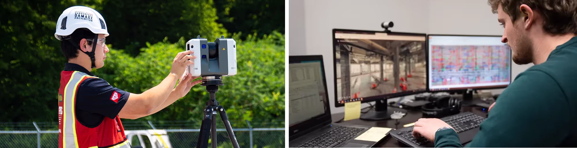
Securing accurate measurements for as-builts, designs, and offsite work is often a challenge for general contractors, architects, and engineers. This is especially true in high-traffic, complex, or hard-to-reach areas, where getting accurate measurements puts your crew at risk of injury or where there is no way to capture measurements by hand. 3D laser scanning is revolutionizing construction workflows, and companies are turning to GPRS to provide as-built services to plan and expedite projects.
GPRS is a leading 3D laser scanning company in the Unites States, helping clients to successfully complete their most complex construction projects with accurate as-built documentation. Our team of Project Managers and CAD designers deliver the highest quality point clouds, 2D CAD drawings, 3D BIM models, 3D Mesh models, TruViews, Virtual Tours, and more using state-of-the-art equipment, technology, and processes.
Laser scanning is a highly accurate method of capturing the as-built survey details of an existing building or construction site. By using laser light, LiDAR scanners create 3D representations known as point clouds. These point clouds contain data that is used to create a 3D laser map of the precise shape and size of physical objects. General contractors, architects, and engineers can better visualize and plan their designs using the real-world building data as a foundation.

GPRS Construction 3D Laser Scanning Services
Securing accurate measurements for as-builts, designs, and offsite work is often a challenge for general contractors, architects, and engineers. This is especially true in high-traffic, complex, or hard-to-reach areas, where getting accurate measurements puts your crew at risk of injury or where there is no way to capture measurements by hand. 3D laser scanning is revolutionizing construction workflows, and companies are turning to GPRS to provide as-built services to plan and expedite projects.
GPRS is a leading 3D laser scanning company in the Unites States, helping clients to successfully complete their most complex construction projects with accurate as-built documentation. Our team of Project Managers and CAD designers deliver the highest quality point clouds, 2D CAD drawings, 3D BIM models, 3D Mesh models, TruViews, Virtual Tours, and more using state-of-the-art equipment, technology, and processes.
Laser scanning is a highly accurate method of capturing the as-built survey details of an existing building or construction site. By using laser light, LiDAR scanners create 3D representations known as point clouds. These point clouds contain data that is used to create a 3D laser map of the precise shape and size of physical objects. General contractors, architects, and engineers can better visualize and plan their designs using the real-world building data as a foundation.
Construction 3D Laser Scanning Services

Construction Laser Scanning
- As-Builts of Existing Site Conditions
- New Construction Verification
- Construction Coordination
- Renovations & Retrofits
- Design Planning for Facility Upgrades
- Architectural & Historical Documentation
- Clash Detection
- Prefabrication
- Sequencing, Scheduling and Simulations

Why Choose GPRS?
- Industry Leader in 3D Laser Scanning
- Nationwide Service
- Experienced Scan Technicians
- Fast Mobilization and Data Collection
- Survey-Grade Laser Scanners
- In-House Design and CAD Experts
- Optimized Workflow for Quick Turnaround
- Trusted by the Best-Known Companies
- Exceptional Service for Every Client

Customized Deliverables
- Point Clouds
- 2D CAD Drawings
- 3D BIM Models
- Deformation Analysis
- Floor Flatness & Levelness Analysis
- Overhead Clearances
- Structural Steel Probability Analysis
- Volume Calculations
- Wall Plumb Analysis


.avif)


What Are the Benefits of 3D Laser Scanning?
3D laser scanning is fast, accurate and reliable. Three-dimensional data provides exact measurements of sites with a level of confidence and speed not possible with traditional tools. There’s no better way to drive decision making than to have accurate and intelligent, real-time data.
- Fast, Accurate Data Collection: A single laser scan captures millions of 3D data points per second, providing incredibly rich detail of a building or project site. Datasets are dimensionally accurate, measurable and shareable, expediting project planning and execution.
- Eliminates Revisits and Disruption: Sites are captured in high detail the first time, eliminating the need for return visits. High speed data collection expedites projects that require minimal disruption.
- Reduces Costs and Change Orders: Accurate design plans are produced from the start expediting field work and reducing change orders, delays and costs.
- Safe and Non-Contact: 3D laser scanners collect data on tripods from a distance in hard-to-reach or hazardous locations, keeping workers out of harm’s way. The non-intrusive nature keeps historic sites and artifacts untouched.
- Improves Communication: Communication is improved, teams can discuss plans while each has access to the same information, creating a more dynamic working environment.

What is the GPRS 3D Laser Scanning Process?
GPRS is a leading provider of 3D laser scanning services, helping clients to successfully complete their most complex architecture, engineering, and construction projects with accurate as-built documentation and custom 2D CAD and 3D BIM deliverables. The 3D laser scanning process at GPRS involves the following steps:

Plan
Our experienced team works with each client to understand their project scope and provide optimal solutions.

Scan
Highly-trained Project Managers efficiently scan each site with Leica laser scanners, capturing millions of 2-4mm accurate data points.

Register
The GPRS Mapping & Modeling Team registers and processes the point cloud, removing noise, and setting the coordinate system to provide the most precise measurements possible.

Process
Point cloud, 2D, and 3D deliverables are created in-house, giving clients the ability to effectively plan, design, construct, and manage projects.

QA|QC
The GPRS Mapping & Modeling Team has a rigorous quality control process, inspecting all deliverables to provide the most accurate data for clients.

Deliver
We are dedicated to serving and satisfying clients, delivering the highest quality data, 2D CAD drawings, and 3D BIM models on time and on budget.
///INDUSTRIES We serve

Power Transmission & Distribution

Telecom

Renewable Energy

Oil & Gas

Power Generation

Facilities

One Call

Environmental Due Diligence

Civil, Road & Bridge

Design Builds & Remodels

Education

Retail & Restaurant Construction

Water & Sewer
Electric Vehicle Charging

Engineering & Surveying
Other
Want to Know More About 3D Laser Scanning in Construction?
Are you using 3D laser scanning on your construction projects? Every construction professional would benefit from learning the advantages of 3D laser scanning buildings or construction sites. Many construction projects lack current records or as-built drawings. This information is critical for construction planning because it helps engineers to expedite design planning using the real-world building data as a foundation.
Understanding how 3D laser scanning can benefit your construction business is an important step in improving overall efficiency and profitability, whether you’re embarking on a new build, a renovation, or facility maintenance. As built laser scanning allows you to gather accurate, detailed information about existing site conditions. Data is collected in a point cloud, a database of millions of x, y, and z data points in a 3D coordinate system. Accurate to within 2-4mm, this is a precise digital record of a building or site.
How is Laser Scanning Used in Construction?
Originally, a 3D laser scanning survey was used in the construction and maintenance of industrial plant facilities. Laser scanning has since been adopted for many other uses, including design, construction, renovations, and so much more.
- Design: Laser scanning is the best way to begin design planning. Construction engineers can utilize a scan-to-BIM method to capture detailed site information. Building Information Modeling (BIM) gives engineers, architects and contractors the opportunity to design the details of a building virtually. It accelerates design planning and reduces miscalculations, change orders and material waste. Buildings that begin with BIM are often built with great efficiency.
- Construction: Laser scanning provides advantages for construction coordination, specifically in avoiding conflicts between different systems, such as HVAC, electrical, and plumbing. Data can be shared to help with remote coordination. 3D building scanning services aren’t just performed at the beginning of a project either; they can be done at various other points along the timeline to better document construction progress, reduce change orders and share work to other trade professionals. Laser scanning in construction can also document errors and identify a faster solution. 3D laser scanning expedites prefabrication by documenting existing structural elements to plan for modifications.
- Renovations, Operations, and Retrofits: 3D building scanners capture a very high level of detail, and this helps create a permanent as-built record for both owners and facility managers. This data can help with building operations, modifications, renovations, and future building additions.
What are a Few 3D Laser Scanning Tips to Get Started?
- Start with laser scanning: When it comes to utilizing 3D laser scanning on your projects, the earlier you implement it, the better. Ensuring the highest level of accuracy starts with 3d laser scanning right from the project start
- Prepare the right information: Preparing the right information before you request a quote for laser scanning services can bring huge benefits. Tell your 3D laser scanning service provider everything they need to know about your project up front and you will speed up the quoting process, streamline the work, and save yourself a lot of time and money
- Use CAD software: Don’t just think of laser scanning in construction as the final deliverable — be sure to use it simultaneously with survey scanning software for your projects. It works together with BIM and can be used to create a more detailed and accurate BIM models
Why Choose GPRS?
- Every GPRS Project Manager completes an extensive training program to completing 80 hours of classroom training and 320 hours of field mentoring ensure their competence in laser scanning equipment and field knowledge to provide the best possible results for every project.
- We use industry-leading Leica survey-grade laser scanners to capture comprehensive point cloud data with 2-4mm accuracy. The data produced is complete, clean, accurate, and well filtered with low range noise.
- GPRS point clouds provide powerful and dynamic information for a project. By representing spatial data as a collection of x, y, and z coordinates, point clouds deliver large datasets that can be mined for information.
- Our in-house Mapping & Modeling Team transforms point clouds into 2D CAD drawings, 3D BIM models, 3D meshes, TruViews, and virtual tours of the highest quality standards.
- Partnering with GPRS delivers you accurate as built data, maps, and models to expedite project planning and reduce change orders, delays, and costs.
Recent GPRS 3D Laser Scanning Projects
GPRS has helped thousands of companies implement 3D laser scanning into their construction projects. Our team's expertise and attention to detail delivers accurate site data and intelligent models for every project. Here are a few examples of our recent 3D laser scanning services:
3D Laser Scanning Stadiums
GPRS captured the existing conditions of this NFL stadium for our client to create virtual fans for Fox Sports. The existing spatial layout was captured in .rcp format, including the stadium footprint, field, aisles, seating, columns, roof, Jumbotron, score board and field goal posts. 3D laser scanning can be used to create engaging virtual reality experiences.
"We entrusted GPRS to fly around the country and scan several NFL stadiums. They are the best in the biz at what they do." DAN P. -- MANAGING DIRECTOR

3D Laser Scanning Manufacturing Facilities
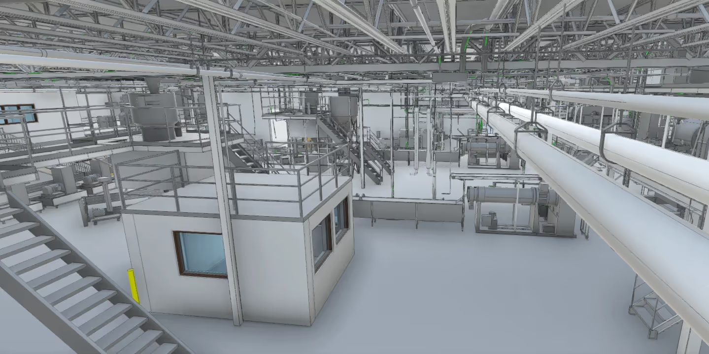
425,000 sq ft of space was 3D laser scanned to capture as-built site data for an upcoming project at a tool manufacturing facility. A registered point cloud was converted to a LOD 300 Revit model and 2D CAD plans. In two weeks on site, taking 2,192 laser scans, two Project Managers captured every structural and MEP detail.

3D Laser Scanning Hotels
GPRS captured as-built data of this hotel for renovation. The client needed accurate 2D floor plans of the architectural and structural elements of the hotel interior, including common areas, guest rooms, meeting rooms, and offices. GPRS can capture a complete full interior layout of any hotel with incredible efficiency - minimizing time and disturbance and eliminating site revisits for missed measurements. Read the case study.

3D Laser Scanning Water Treatment Facilities
59 acres and 27 buildings were 3D laser scanned to provide complete as-built documentation of a Colorado Wastewater Treatment Plant. This 3D model of the digester facility is accurate to within millimeters.

3D Laser Scanning Office Space
3D laser scanning helped to develop as-built drawings, plans, and specifications necessary for construction space planning, and furniture placement for this corporate office.
"Scans are one of the most amazing tools we use right now. At the estimating stage, it's critical. Many details are missed if you only have a 2D drawing. With a laser scan we can visually see complex areas, height differences, and material changes like you’re there in person." CHRIS L. -- PRECONSTRUCTION SERVICES

3D Laser Scanning Churches
One of the oldest standing buildings in Austin, Texas suffered damages during a winter storm and was in need of renovation. No as-built documentation existed for this 3-story church. 19,000 sq ft was scanned with the Leica RTC360 laser scanner. In 149 scans, every detail was measured and documented. An LOD 200 Revit 3D model was delivered to the client.

3D Laser Scanning to Expedite the Installation of ACM Panels
Our client was installing ACM (Aluminum Composite Material) panels to the canopy of a newly constructed airport terminal. By working closely with the client, GPRS was able to provide the exact measurements needed in order to properly install the ACM panels. Read the case study.
"GPRS has changed the way we field measure, layout, and install projects." VINCENT N. -- SUPERINTENDENT

3D Laser Scanning Processing Plants
When plant engineers at a pet food packaging facility needed to make modifications, they asked GPRS 3D Laser Scanning to provide as-built documentation and a 3D BIM model to plan retrofits to the existing structure. Point cloud data and a 3D BIM model was created for this processing plant in Kentucky. 40,000 sq. ft. and 7 levels of elevated platforms containing product packaging equipment were captured with millimeter accuracy.

3D Laser Scanning The Virginia Air and Space Museum
The museum’s design team wanted a digital representation of the space to begin design planning and renovation. GPRS 3D laser scanned the museum in less than 2 hours in the early morning to avoid interrupting visiting hours.
"GPRS had a quick turnaround on deliverables that saved time within the project. We look forward to working with them on future projects." MICHAEL T. -- DIRECTOR OF FACILITIES, The Virginia Air and Space Museum.

3D Laser Scanning Pricing
Laser scanning is quickly becoming the first step in construction projects. If you’re not already using it, now is the time to start looking into bringing the technology to your projects. The technology is transforming the way contractors work. By replacing manual processes and allowing software to capture and share information throughout the organization, construction companies can focus on delivering their project on time and under budget. With accurate project information, you can:
- Boost efficiency and productivity
- Communicate more effectively between field and office
- Avoid rework that can derail budgets and schedules
The cost of 3D laser scanning can vary depending on your project scope. GPRS customizes every quote specific to your project’s needs. GPRS Project Managers use 3D laser scanners to capture every detail of your site, delivering building dimensions, locations, and layout with millimeter accuracy. This can include the aboveground structural, architectural, and MEP features, plus underground utility and concrete markings. Our Mapping & Modeling Team can deliver point clouds, 2D CAD drawings, 3D BIM models, 3D Mesh models, TruViews, and Virtual Tours at any level of detail.


Articles

Scan-to-BIM technology helps you take any project from inception to completion with accurate and easy to understand data integration to ensure smooth communication and avoid cost overruns and delays. What project can GPRS help you visualize?
Laser scanning is an unmatched facility documentation and management tool with benefits that span the life of any facility. Our Project Managers, model designers, and CAD designers work together to help you Visualize The Built World® to help you reduce downtime and costs so that your projects come in on time and on budget.
USIBD is an organization dedicated to creating standards for building documentation. GPRS 3D Laser Scanning strongly believes in the importance of creating specifications and guidelines for the US construction industry. These established criteria drive quality excellence, improve efficiencies, establish expectations and build credibility. For these reasons, GPRS is proud to be a member of US Institute of Building Documentation.
GPRS 3D Laser Scanning is an unmatched facility documentation and management tool with benefits that span the life of any facility. Our Project Managers, model designers, and CAD designers work together to help you Intelligently Visualize The Built World™ to help you reduce downtime and costs so that your projects come in on time and on budget.