

.svg)
GPRS Delivers Accurate As-Builts with 3D Laser Scanning
No construction project goes exactly according to plan, and it is difficult for contractors to keep a record of all design changes and reworks that were made during the building process. When completing a construction or renovation project, or building modification, it is important to have an as-built: the exact dimensions and locations of all building elements.
As-builts are often out-of-date and inaccurate, leading to unexpected issues and project delays. An accurate record of existing conditions can expedite project planning and decision making. Construction, renovations, and modifications can proceed smoothly when teams have precise architectural, structural, and MEP system layout, dimensions, and specifications. Accurate as-builts reduce the delays and costs from mistakes and reworks made from working with outdated plans.
What are As-Built Drawings?
As-builts are the set of drawings or plans that represent the current state of a building or site. Buildings can go through many modifications during the construction process. For example, the location of a wall, window, or system component can be moved or relocated. As-builts provide an accurate record of the current building information, including architectural, structural, utility, and MEP system dimensions, locations, and material specifications.
As-builts can be recorded throughout the life cycle of a project. They can be generated during construction to document design changes from the original plans. And, they can be produced by general contractors and/or subcontractors at the end of a job, during closeout. These are often referred to as final as-builts or for-record as-builts.

How Do You Capture an As-Built?
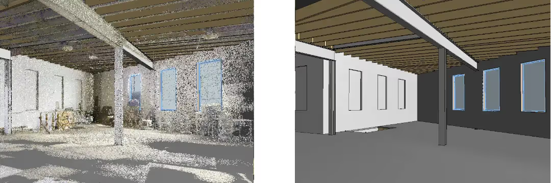
3D laser scanning is the best method to capture precise measurements and aboveground details of a project site. 3D laser scanning uses LiDAR technology to quickly record the existing conditions of a building, site, or facility in the form of a point cloud. The precise details of the exterior and interior of buildings, foundations, structure, piping, and equipment are captured with millimeter accuracy, delivering exact building dimensions, locations, and layouts.
Point cloud data can be opened in CAD software, such as Revit and AutoCAD, to generate highly detailed 2D CAD drawings, 3D BIM models, 3D meshes, TruViews, virtual tours, utility locate maps and more.
How Can Accurate As-Builts Save Time and Money?
According to a report from Autodesk and FMI, poor project data and miscommunication account for 48% of all rework on U.S. construction sites. They state that professionals spend four hours a week dealing with rework-related activities, such as managing the mistakes on a project that result in rework, assessing the associated costs, and determining why the mistakes happened.
Furthermore, this lack of information and bad data results in poor decision-making. In another study from Autodesk and FMI, decisions made using “bad data” are estimated to have cost the global industry $88.69 billion in rework alone, accounting for 14% of all rework performed in 2020.
Complete and accurate as-built data ensures project teams have precise building layouts to improve communication, ensure reliable project planning, determine project costs, reduce change orders, assign tasks to the construction team, and record construction progress. GPRS 3D Laser Scanning services deliver updated as-builts for peace of mind before beginning any construction project.
These are some of the benefits of as-built plans:
- Obtain Building Layout – Having a precise building layout is crucial in design planning, construction management, and facility maintenance. Accurate floor plans and 3D models with 2-4mm accuracy help project teams expedite design planning and save time by knowing the locations of the building components and systems on site.
- Improve Communication – Communication is improved, teams can discuss plans while each has access to the same information, creating a more dynamic working environment. As-builts decrease calls, emails, and messages with a single source of truth.
- Expedite Project Planning – As-builts are dimensionally accurate, measurable, and shareable data sets for reliable project planning.
- Estimate Project Costs – Information on project layout and building materials allows teams to specify design changes and estimate costs.
- Reduce Change Orders – Accurate design plans are produced from the start, expediting fieldwork and reducing change orders and delays.
- Assign Tasks to Construction Team – Project Managers provide the team with the proposed design and assign tasks to the construction team, reducing project downtime.
- Record Construction Progress – As-built drawings allow contractors to track the progress of the project and see what work needs to be completed, allowing them to set realistic completion dates.
Who Uses As-Builts in Construction?
Construction projects are complex and dynamic. Accurate as-builts help to plan and manage unforeseen site conditions that may arise during the construction process.
These are some of the project stakeholders who utilize as-builts:
- Contractors – The contractor is usually overseeing the actual building construction, as-built drawings and models are a crucial source of information, as they communicate the existing building conditions and take all guesswork out of the equation.
- Design Teams – Use as-builts as a clear starting point for construction planning, with access to accurate data, they can detail the additions, deletions, and other changes made to a project during the design process.
- Engineers – Use precise as-built data such as dimensional comparisons, floor surface contours, bolt hole locations, and precise prefabrication measurements for solving complex engineering challenges.
- Facility Maintenance Teams – Utilize as-builts to understand the layout and components of infrastructure, systems, and utilities, making it easier to perform repairs, updates, or routine maintenance tasks.
- Architects – Use as-builts in the form of 3D BIM models to complete design plans with accurate data and share access to all project stakeholders.
- Real Estate Professionals – Use as-built drawings to assess the property's condition and layout and ensure its compliance with codes and regulations.
- Environmental Consultants – Use as-built drawings, maps, and models to identify underground utilities and potential environmental hazards on a property and get the crews home safely.
GPRS Delivers Accurate As-Builts
GPRS delivers accurate and up-to-date as-builts for architecture, engineering, and construction professionals to get crews up to speed in real time. When you choose GPRS 3D Laser Scanning services, you provide your team with precise as-built data for reliable project planning, reducing the risk of change orders and project delays.
GPRS’ elite Project Managers collect millions of precise data points for a building or site with industry-leading Leica LiDAR laser scanners. Our Mapping & Modeling Team works with each client to create custom deliverables that aid in the design, planning and execution phases of any project.
GPRS 3D Laser Scanning services provide accurate as-builts to Intelligently Visualize Your Built World™.

GPRS Delivers Accurate As-Builts with 3D Laser Scanning
No construction project goes exactly according to plan, and it is difficult for contractors to keep a record of all design changes and reworks that were made during the building process. When completing a construction or renovation project, or building modification, it is important to have an as-built: the exact dimensions and locations of all building elements.
As-builts are often out-of-date and inaccurate, leading to unexpected issues and project delays. An accurate record of existing conditions can expedite project planning and decision making. Construction, renovations, and modifications can proceed smoothly when teams have precise architectural, structural, and MEP system layout, dimensions, and specifications. Accurate as-builts reduce the delays and costs from mistakes and reworks made from working with outdated plans.
What are As-Built Drawings?
As-builts are the set of drawings or plans that represent the current state of a building or site. Buildings can go through many modifications during the construction process. For example, the location of a wall, window, or system component can be moved or relocated. As-builts provide an accurate record of the current building information, including architectural, structural, utility, and MEP system dimensions, locations, and material specifications.
As-builts can be recorded throughout the life cycle of a project. They can be generated during construction to document design changes from the original plans. And, they can be produced by general contractors and/or subcontractors at the end of a job, during closeout. These are often referred to as final as-builts or for-record as-builts.
How Do You Capture an As-Built?
3D laser scanning is the best method to capture precise measurements and aboveground details of a project site. 3D laser scanning uses LiDAR technology to quickly record the existing conditions of a building, site, or facility in the form of a point cloud. The precise details of the exterior and interior of buildings, foundations, structure, piping, and equipment are captured with millimeter accuracy, delivering exact building dimensions, locations, and layouts.
Point cloud data can be opened in CAD software, such as Revit and AutoCAD, to generate highly detailed 2D CAD drawings, 3D BIM models, 3D meshes, TruViews, virtual tours, utility locate maps and more.
How Can Accurate As-Builts Save Time and Money?
According to a report from Autodesk and FMI, poor project data and miscommunication account for 48% of all rework on U.S. construction sites. They state that professionals spend four hours a week dealing with rework-related activities, such as managing the mistakes on a project that result in rework, assessing the associated costs, and determining why the mistakes happened.
Furthermore, this lack of information and bad data results in poor decision-making. In another study from Autodesk and FMI, decisions made using “bad data” are estimated to have cost the global industry $88.69 billion in rework alone, accounting for 14% of all rework performed in 2020.
Complete and accurate as-built data ensures project teams have precise building layouts to improve communication, ensure reliable project planning, determine project costs, reduce change orders, assign tasks to the construction team, and record construction progress. GPRS 3D Laser Scanning services deliver updated as-builts for peace of mind before beginning any construction project.
These are some of the benefits of as-built plans:
- Obtain Building Layout – Having a precise building layout is crucial in design planning, construction management, and facility maintenance. Accurate floor plans and 3D models with 2-4mm accuracy help project teams expedite design planning and save time by knowing the locations of the building components and systems on site.
- Improve Communication – Communication is improved, teams can discuss plans while each has access to the same information, creating a more dynamic working environment. As-builts decrease calls, emails, and messages with a single source of truth.
- Expedite Project Planning – As-builts are dimensionally accurate, measurable, and shareable data sets for reliable project planning.
- Estimate Project Costs – Information on project layout and building materials allows teams to specify design changes and estimate costs.
- Reduce Change Orders – Accurate design plans are produced from the start, expediting fieldwork and reducing change orders and delays.
- Assign Tasks to Construction Team – Project Managers provide the team with the proposed design and assign tasks to the construction team, reducing project downtime.
- Record Construction Progress – As-built drawings allow contractors to track the progress of the project and see what work needs to be completed, allowing them to set realistic completion dates.
Who Uses As-Builts in Construction?
Construction projects are complex and dynamic. Accurate as-builts help to plan and manage unforeseen site conditions that may arise during the construction process.
These are some of the project stakeholders who utilize as-builts:
- Contractors – The contractor is usually overseeing the actual building construction, as-built drawings and models are a crucial source of information, as they communicate the existing building conditions and take all guesswork out of the equation.
- Design Teams – Use as-builts as a clear starting point for construction planning, with access to accurate data, they can detail the additions, deletions, and other changes made to a project during the design process.
- Engineers – Use precise as-built data such as dimensional comparisons, floor surface contours, bolt hole locations, and precise prefabrication measurements for solving complex engineering challenges.
- Facility Maintenance Teams – Utilize as-builts to understand the layout and components of infrastructure, systems, and utilities, making it easier to perform repairs, updates, or routine maintenance tasks.
- Architects – Use as-builts in the form of 3D BIM models to complete design plans with accurate data and share access to all project stakeholders.
- Real Estate Professionals – Use as-built drawings to assess the property's condition and layout and ensure its compliance with codes and regulations.
- Environmental Consultants – Use as-built drawings, maps, and models to identify underground utilities and potential environmental hazards on a property and get the crews home safely.
GPRS Delivers Accurate As-Builts
GPRS delivers accurate and up-to-date as-builts for architecture, engineering, and construction professionals to get crews up to speed in real time. When you choose GPRS 3D Laser Scanning services, you provide your team with precise as-built data for reliable project planning, reducing the risk of change orders and project delays.
GPRS’ elite Project Managers collect millions of precise data points for a building or site with industry-leading Leica LiDAR laser scanners. Our Mapping & Modeling Team works with each client to create custom deliverables that aid in the design, planning and execution phases of any project.
GPRS 3D Laser Scanning services provide accurate as-builts to Intelligently Visualize Your Built World™.
As-Built Laser Scanning Applications
- As-built survey, reality capture or existing conditions survey
- Construction verification, sequencing, scheduling, and simulations
- Design engineering for facility upgrades or expansions
- Prefabrication
- Clash detection
- Architectural documentation or historical preservation
- Create a digital twin of buildings, sites, facilities, and warehouses
- Calculate volumes, deformation analysis, and overhead clearances
- Virtual design and construction
- Laser scanning for facility coordination
- Collect geospatial data
As-Built Deliverables
- Point Cloud Data
- 2D CAD Drawings
- 3D BIM Models | Building Information Models
- 3D Mesh Models
- 3D Photogrammetry
- TruView
- Virtual Tours via WalkThru 3D
- 2D Floor Plans via FLRPLN
- 3D CAD Floor Plans via FLRPLN
- Template Modeling
- Reconciliation of Clients 2D Drawings
- Reconciliation of Clients 3D Design Model
- Comparative Analysis
- Deformation Analysis
- Floor Flatness Analysis | Floor Contour Mapping
- Volume Calculations
- Structural Steel Shape Probability Analysis
- Wall Plumb Analysis
- New Construction Accuracy Analysis
- New Construction Comparative Analysis
- 2D CAD of GPR Markings
- Reflected Ceiling Plans
- Emergency Floor Plans
- 2D CAD Plan Views, Elevations, Sections, Details, Isometric Drawings
Modeling Software
- Autodesk Recap
- Autodesk Revit
- Autodesk 3DS Max
- Autodesk Navisworks
- Autodesk Autocad Civil 3D
- Autocad Map 3D
- Bentley MicroStation
- Bentley Descrates V8i
- ClearEdge 3D Edgewise
- PointSense Kubit
- Leica Cyclone
GPRS Has Provided As-Built Scanning for Many Industries
- Agricultural Facilities
- Architectural Documentation
- Concrete Construction
- Construction
- Clash Detection
- Design Build
- Energy & Utilities
- Engineering
- Government, Defense & Military Sector
- Healthcare & Pharmaceutical
- Historical Documentation & Preservation
- HVAC & MEP Coordination
- Industrial, Manufacturing, Assembly & Distribution Facilities
- Mixed Reality & 3D Projection Mapping
- Office & Commercial Buildings
- Overhead Clearances
- Oil & Gas Facilities
- Power Plants & Process Plants
- Real Estate
- Stadiums, Arenas & Theatres
- Telecommunications
- Schools & Universities
- Subsurface Utility Engineering
- Virtual Design and Construction
- Water & Wastewater Treatment Plants
- Accident Reconstruction
- 3D Video Gaming & Software Development
A partner like GPRS will deliver accurate as-built data and deliverables to expedite project planning and reduce change orders, delays, and costs. We have saved clients millions of dollars in lost productivity and materials with accurate as-built measurements to aid in design, visualization, space definition, prefabrication, and clash detection.


.avif)


3D Laser Scanning Pricing
The cost of 3D laser scanning can vary widely depending on your project scope. GPRS customizes every quote specific to your project’s needs. GPRS Project Managers use 3D laser scanners to capture every detail of your site, delivering building dimensions, locations, and layout with millimeter accuracy. This can include the aboveground structural, architectural, and MEP features, plus underground utility and concrete markings. Our Mapping & Modeling Team can deliver point clouds, 2D CAD drawings, 3D BIM models, 3D Mesh models, TruViews, and Virtual Tours at any level of detail.
Contact us today to see the expertise and value that GPRS Laser Scanning can provide at Laser@gprsinc.com or call 419-843-7226 (SCAN). We’re currently offering 10-minute presentations – would you like to schedule one? Click here.
///INDUSTRIES We serve

Power Transmission & Distribution

Telecom

Renewable Energy

Oil & Gas

Power Generation

Facilities

One Call

Environmental Due Diligence

Civil, Road & Bridge

Design Builds & Remodels

Education

Retail & Restaurant Construction

Water & Sewer
Electric Vehicle Charging

Engineering & Surveying
Other
Case Studies
.webp)


Scan-to-BIM technology helps you take any project from inception to completion with accurate and easy to understand data integration to ensure smooth communication and avoid cost overruns and delays. What project can GPRS help you visualize?
Laser scanning is an unmatched facility documentation and management tool with benefits that span the life of any facility. Our Project Managers, model designers, and CAD designers work together to help you Visualize The Built World® to help you reduce downtime and costs so that your projects come in on time and on budget.
USIBD is an organization dedicated to creating standards for building documentation. GPRS 3D Laser Scanning strongly believes in the importance of creating specifications and guidelines for the US construction industry. These established criteria drive quality excellence, improve efficiencies, establish expectations and build credibility. For these reasons, GPRS is proud to be a member of US Institute of Building Documentation.
GPRS 3D Laser Scanning is an unmatched facility documentation and management tool with benefits that span the life of any facility. Our Project Managers, model designers, and CAD designers work together to help you Intelligently Visualize The Built World™ to help you reduce downtime and costs so that your projects come in on time and on budget.