

.svg)
The cost of 3D laser scanning a building depends on the size and complexity of what is being scanned. GPRS can price 3D laser scanning jobs quickly because we have experience in all industries for all scopes of work.
What is a Needs Assessment?
Before we discuss cost, GPRS starts with a needs assessment. This is a short phone call that helps define what you need the site data to do. The purpose of the deliverable drives the scope, the accuracy level, and the level of detail (LOD) required. A renovation plan, a building expansion, a concrete slab quality check, or a utility conflict review can all call for different outputs and reality capture methods.
This call also helps customize the deliverables to your project’s needs. If you’re an architect or an engineer, you may need higher accuracy and more detailed modeling for design and coordination.
If you’re a facility manager, you may only need a reliable floor plan or an area analysis for planning and leasing. When we understand the goal up front, we can recommend the most efficient approach and get you exactly what you need.
According to Matt Mikolajczyk PE, GPRS’ Director of Reality Capture, “we can accommodate any type of request, all the way from a simple floor plan with an evacuation route to a BOMA area analysis, all the way through high detail MEP for a large processing unit that's being added to a facility. So, because of those factors, there are many options and a lot of things that we need to consider.”
Here is a list of items a GPRS Project Manager will assess when determining the scope and cost of your 3D laser scanning project.
- Location
- Scope of work
- Square footage
- Site images
- Site plans
- Building or site complexity
- Number of rooms
- Building or site access and occupancy
- Special requirements, such as night or weekend scanning
- Equipment selected (LiDAR or Photogrammetry)
- Greyscale or color 3D laser scanning
- 3D Virtual Tour access
- Deliverables needed (CAD/BIM/MEP/Mesh/BOMA)
- Client template & client standards
- Accuracy and level of detail requirements (if CAD drawings or 3D modeling are needed)
- Project timeline
In the sections below, we’ll show how each factor impacts pricing. We’ll also help you pick the best deliverables that suit your project’s goals.
How 3D Laser Scanning Field Collection and Technology Affects Pricing
3D Laser Scanning Density
The price of 3D laser scanning is not based on square footage alone.
“Based on the technology that's chosen for that project and the density of scanning that's required, we have different price points for different accuracies,” said Mikolajczyk PE.
Scan density is the level of detail collected during the 3D laser scanning fieldwork. Higher density means the scanner captures more information in that area. That can be important when small features matter, such as pipes, conduit, ductwork, valves, and equipment.
Higher density usually calls for more scan positions and more time on-site. It also creates larger datasets that take longer to register, process, and quality-check in the office.
Lower-density 3D laser scans can be faster and more cost-effective when the space is simple, and the deliverable does not need a high level of detail.
Greyscale vs. Colorized 3D Laser Scanning
The default mode for 3D laser scanning is greyscale. This describes how the point cloud appears in software such as Revit and TruView. During the capture, the scanner assigns each point a greyscale value (0–100) based on surface reflectivity and the angle of incidence.
Lighting is not required for greyscale scanning. The scanner can capture this data even in the pitch dark.
Construction-grade 3D laser scanners also include built-in digital cameras for full-color reality capture. After the initial scan, the scanner performs a second rotation to take hundreds of images, stitching them together into a single color, stereoscopic picture. The software then uses that panorama to colorize the 3D points, resulting in a full-color point cloud.
.webp)
Building Type
The building type also plays a role in choosing the right density. An open warehouse is often faster to capture because it has clear sightlines and fewer tight spaces.
Technologies Required
Once we understand the building, the required scanned area, density, and scope of work, we select the best reality capture technology (or technologies) to capture the space. Different technologies offer different levels of speed and accuracy, so they come with different price points.
For example, a project may work well with a fast capture method, such as photogrammetry or lower-accuracy LiDAR, or it may need a construction-grade LiDAR scanner to achieve millimeter-level precision.
Technology choice can also introduce project-specific costs beyond 3D laser scanning. Some workflows include fees for scan registration, point cloud processing, or virtual tour access.
In some cases, we may need to ship specialized equipment if we do not have it immediately available, and that can add logistical costs.
Time in the field matters as well. If a tool needs more time per scan position, the cost increases even when the building size stays the same.
That is why GPRS prices 3D laser scanning by matching the building type, density level, accuracy requirements, and deliverables to the ideal reality capture technology. When the scope of work is clearly defined at the beginning of your project, we can choose the right approach, control costs, and deliver data that is ideal for your project’s workflows.
Deliverable Requirements and Pricing
After the 3D laser scanning approach is set, the next cost driver is the deliverables. This is where pricing can vary the most, because the scan data can be turned into different outputs depending on how you plan to use it. GPRS’ Reality Capture Team provides a full range of deliverables, including:
- 3D Point Clouds
- Virtual Tours
- 3D BIM Models
- Above and Below-Ground BIM Models
- 3D Mesh Models
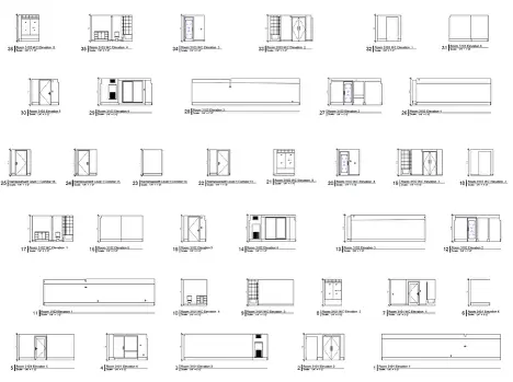
- 2D CAD Drawings
- Utility & Structural As-Builts
- BOMA-Compliant Lease Plans and Area Analysis
- SiteMap® Reality Capture Layer
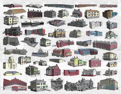
Deliverables typically start with a choice between 2D CAD drawing and 3D BIM model. A simple 2D floor plan is usually faster to create than a full 3D model or an at-depth model. A 3D deliverable may call for more steps, such as modeling, object classification, and more quality control.
How Much Does 3D Modeling Cost?
A significant part of the project cost can be in the deliverables…but it doesn't always have to be. Oftentimes, clients tell 3D laser scanning service providers that they want “everything” modeled when, in reality, they only need a small area or a certain specific feature modeled. For example, there is no reason to model every piece of steel in a building or every ½” pipe and conduit when the client may only need the steel of a particular platform or no conduit at all, and only pipes that are greater than 2”.
The LOD matters when it comes to modeling. Some projects only need us to capture the shell, while others may require us to capture and model the full interior.
The Client’s Template and Standards
Client template requirements and modeling standards can also affect the modeling time. If you have a CAD/BIM template or specific standards and naming conventions, that affects the cost as well. If you select the GPRS modeling standard, the workflow is often faster and can reduce the cost.
Building Area Type
The type of space and square footage also matters. If a space is gutted, it may be simpler to capture than an occupied or finished space with ceilings, furniture, and MEP systems.
.webp)
Areas Modeled
Deliverables vary from project to project. For CAD outputs, some clients only need a floor plan, while others call for a reflective ceiling plan (RCP) and exterior elevations. Some projects also call for special plan sets. This includes fire and life safety plans. Others might require a designer-level package, which shows detailed finish features, like trim.
In addition to square footage, quantities drive the pricing for certain deliverable outputs.
MEP modeling detail is another key factor in price. If you need an MEP model, our team will assist you in determining if it should be conceptual, detailed, or made for construction documentation.
Some minor tweaks to the modeling scope can lead to a radical change in the price. For instance, if you only need a simple floor plan, GPRS Project Managers can use a high-resolution camera system to produce the floor plan and virtual tour quickly.
If the project demands construction-grade laser scanning, we will register the data and then convert it into CAD software, which increases production time and cost.
Our Mapping and Modeling Team can create anything from a simple GPS-enabled map of your utility locate to CAD drawings and at-depth 3D BIM models, depending on your needs.
We Are a Trusted Partner for 3D Laser Scanning Services
We work with every client to clearly define the project scope so they get what they are expecting and can avoid spending a lot of money on something that is unusable.
We want to partner with you and provide the highest quality laser scanning services at a reasonable cost.
GPRS Laser Scanning has become a trusted partner to many engineers, project managers, architects, designers, developers, owners, and other building professionals. We want to build long-term relationships. Our services help clients avoid change orders, rework, and construction delays.

It's Not Always About the Price
The 3D laser scanning company that bids the lowest price could be taking shortcuts on quality. Be sure to ask the laser scanning service provider about the equipment, employees, and software they use. A lower-priced 3D laser scanning quote could have the following:
- The equipment could be outdated
- The equipment could not have been calibrated recently
- The employees could be unqualified or inexperienced
- The deliverables could be created with unlicensed software
- Employees who arrive on-site may be subcontractors and not affiliated with the company you hired
- On-site crew may be uninsured
GPRS will be price-competitive in the industry without sacrificing quality. We specialize in 3D laser scanning, as-built drawings, and 3D BIM modeling. Having scanned and modeled thousands of projects in many industries, we have a vast portfolio and have many repeat clients that trust us to meet their standards and specifications. Our team works with integrity, passion, and professionalism, upholding the highest standards in 3D laser scanning and modeling services. The individual or team that arrives on your project site will be respectful, insured, informed, and dedicated to your project’s success.
Do I Need a 3D Model for Every Project?
In reality, most projects do not need a model. In fact, many deliverables – such as clash detection, wall plumbness, and orthoimages are actually extracted directly from the point cloud. In addition, some 2D drawings (floor plans, elevations, framing plans, and reflected ceiling plans) can also use the point cloud directly instead of needing to do line work by plotting the point cloud directly on the drawing, and it can even be used for construction documents.
Fair and Honest Pricing
If we have sent you a quote that is outside your budget, just let our team know. We can work with you to meet your budget, schedule, and scope requirements. We can execute projects in multiple stages. For instance, some clients will ask us to 3D scan and model one area of a building in an initial phase and revisit the remainder of the building at a later date. Some clients may only initially need a set of schematic floor plans. Since we have the scan data on file, we can build on it as your needs grow.
GPRS’ Mapping & Modeling Team can also stagger delivery in phases. We can start with your highest-priority areas first, then complete the rest of the work and deliver it as one cohesive model.
Our pricing is transparent. There are no hidden fees and no surprises when you receive your invoice. The price in the proposal is what we will bill you for.

Why Choose GPRS? The GPRS Difference.
GPRS is a leading provider of 3D laser scanning services in the United States, delivering accurate as-builts, point clouds, 2D CAD drawings, and 3D BIM models to expedite project planning. Our elite team of Project Managers utilize state-of-the-art equipment, software, and processes to document architectural, structural, and MEP system layout and dimensions for existing buildings, facilities, and sites.
GPRS provides a comprehensive suite of services and deliverables, and can help you see your site’s as-built information, both above and below-ground. GPRS’ 99.8% accurate utility locating, concrete scanning, along with 3D laser scanning, NASSCO-compliant CCTV video pipe inspection (VPI), and leak detection services deliver accurate utility & structural as-builts, point clouds, 2D CAD drawings, at-depth 3D BIM models, WinCan reports, and routine water loss surveys to keep your projects on time, on budget, and safe. Our elite team of nationwide Project Managers utilize state-of-the-art equipment, software, and processes to document architectural, structural, and MEP system layout and dimensions for existing buildings, facilities, and sites.
What can we help you visualize?
Frequently Asked Questions
What is a GPRS Above and Below-Ground 3D BIM Model?
A GPRS above and below-ground, or at-depth 3D BIM Model, combines structural existing conditions with mapped subsurface infrastructure in one cohesive model. That means architects, engineers, and contractors can review architectural, structural, and MEP conditions alongside layered utility data and as-builts instead of working from separate records. GPRS’ Mapping & Modeling Team works as a well-oiled machine to create this deliverable by combining utility locating, concrete scanning, and 3D laser scanning, and centralizes the geolocated files in SiteMap® for secure access and coordination.
Click here to see how GPRS created an above and below-ground BIM model for a historic Ohio hospital and integrated the captured 3D data into the architect’s design model to evaluate nearly 100 caisson locations before construction began.
How Does GPRS Store Deliverables in the SiteMap Reality Capture Layer?
GPRS stores reality capture deliverables in the SiteMap Reality Capture Layer, a secure cloud-based GIS software that keeps all your 3D laser scanned data and related files in one place. SiteMap allows clients to store and review 2–6 mm accurate reality capture data, and the Reality Capture Layer can house your point clouds, 2D CAD drawings, 3D models, and interactive virtual walkthroughs alongside other site data. We use the SiteMap platform to organize and geolocate those deliverables so architects, engineers, and project teams can analyze existing conditions, coordinate with utility data, and access secure project information from desktop, iPad, or mobile device.
What is the Difference Between a 3D BIM Model and a Digital Twin?
A 3D BIM model is a static, information-rich three-dimensional digital representation of a space, while a digital twin extends that representation into an environment that supports ongoing analysis, monitoring, and lifecycle decision-making.
Autodesk’s scan-to-BIM guidance describes BIM as a precise basis for digital twin creation.
GPRS’ Mapping & Modeling Team helps clients start with scan-to-BIM deliverables such as point clouds, CAD files, and Revit models, then stores that data in SiteMap for design, coordination, and ongoing facility management.
See how GPRS delivered utility maps, a point cloud, a high-detail 3D BIM model, and SiteMap access so engineers could plan additional server integrations without disrupting data center operations, here.
What is the Difference Between Photogrammetry and LiDAR?
Photogrammetry creates 3D data from overlapping images, while LiDAR measures surfaces directly with laser pulses. In practice, LiDAR is usually the better option when you need higher accuracy or low-light performance, while photogrammetry is often a strong fit for rapid reality capture and visually rich point clouds. GPRS helps you choose the right method, or can combine both methods based on required accuracy, site conditions, and deliverables, then converts the captured data into point clouds, floor plans, virtual tours, CAD drawings, BIM models, and more.
Learn more about this process in GPRS’ LiDAR vs. 3D Photogrammetry article, and how to choose which method will best suit your project’s needs.