

.svg)
Telecommunications


Private Utility Locating Services for the Telecom Industry
The telecommunication sector is made up of companies that make communication possible on a global scale, including the companies that provide telephone and wireless services, as well as internet data and video communications.
GPRS is the trusted leader for damage prevention in the telecom industry. Our Project Managers work closely with telecommunications companies to deliver subsurface utility maps and existing conditions documentation for projects in the planning and permitting phase, construction phase, and the operations and maintenance (O&M) phase that immediately benefit the contractors and service providers on site.
Last year, the large-scale adoption of 5G has essentially every telecommunication service provider in the world bolstering its infrastructure to offer 5G functionality. Now more than ever, it’s imperative that our clients quickly receive a comprehensive as-built and subsurface report to ensure that these infrastructure upgrades are not delayed. We have completed projects for many of the large telecom companies in the United States; in fact, our highly trained project managers have experience in all telecom-related settings such as OSP construction, macro tower placement and modifications, ISP placement and installation, small cells, fiber optic installation, and much more.
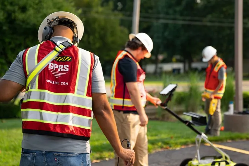
We have built a nationwide network of offices with staff strategically placed in every major metropolitan area in the United States, providing industry-leading response times to meet our clients' needs. When upgrading the wireless infrastructure in a major market, our utility locating, concrete scanning, 3D laser scanning, video pipe inspection, and leak detection services are crucial to preventing utility strikes and project delays.

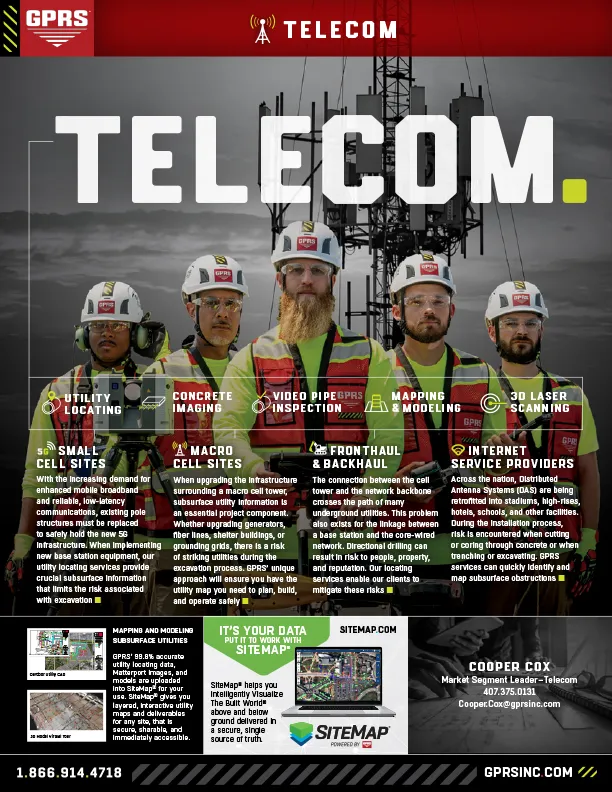
Small Cell Sites
With the increasing demand for enhanced mobile broadband and reliable, low-latency communications, existing pole structures must be replaced to safely hold the new 5G infrastructure. When implementing new base station equipment, our utility locating services, concrete scanning, and 3D laser scanning services provide crucial information that limits the risk associated with excavation.
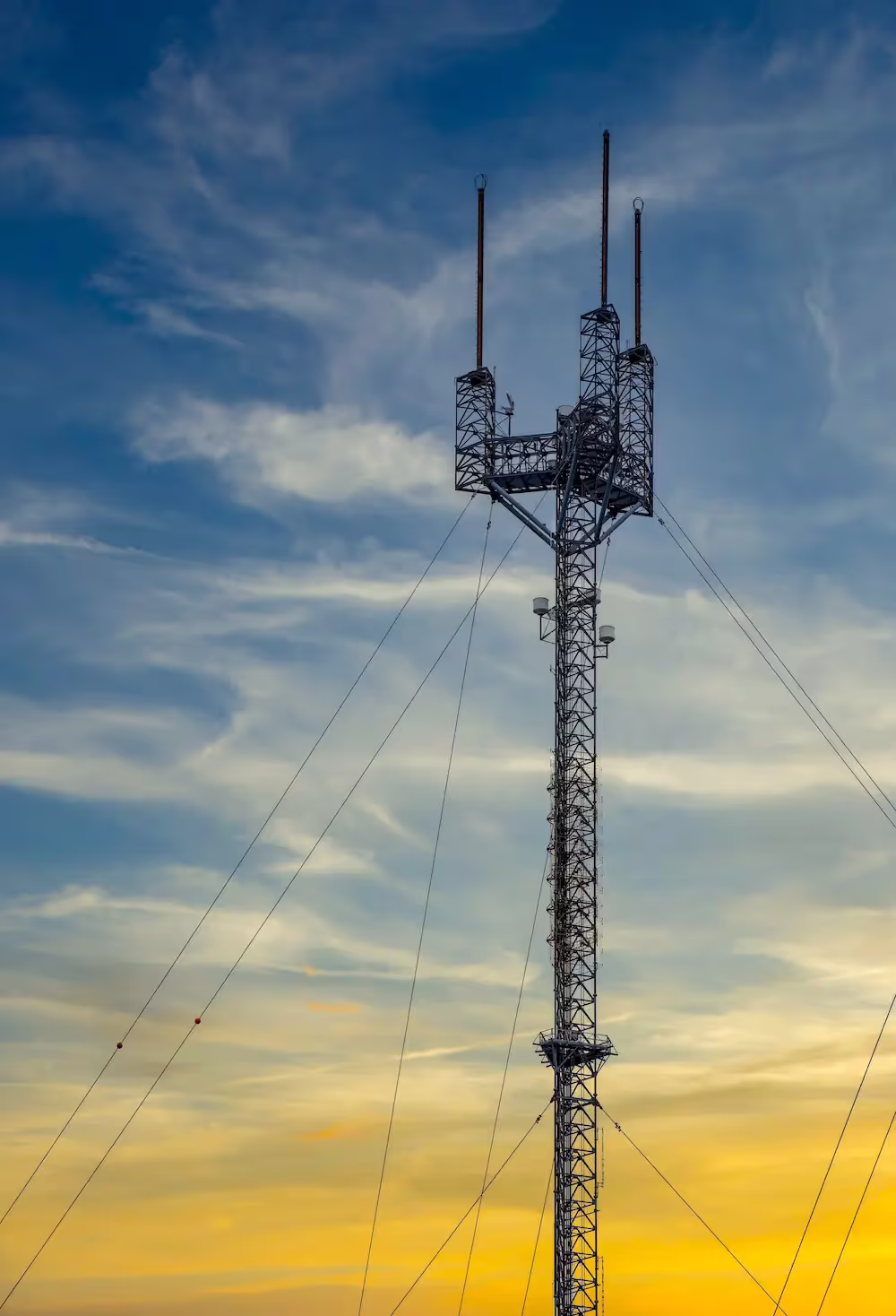
Macro Cell Sites
When upgrading the infrastructure surrounding a macro cell tower, subsurface utility information is an essential project component. Whether upgrading generators, fiber lines, shelter buildings, or grounding grids, there is a risk of striking utilities during the excavation process. GPRS’ unique approach will ensure you have the utility map and as-built site data you need to plan, build, and operate safely.
Fronthaul Backhaul
The connection between the cell tower and the network backbone crosses the path of many underground utilities. This problem also exists for the linkage between a base station and the core-wired network. Directional drilling can result in risk to people, property, and reputation. Our locating services enable our clients to mitigate these risks.
Internet Service Providers
Across the nation, Distributed Antenna Systems (DAS) are being retrofitted into stadiums, high-rises, hotels, schools, and other facilities. During the installation process, risk is encountered when cutting or coring through concrete or when trenching or excavating. GPRS services can quickly identify and map subsurface obstructions and deliver accurate existing conditions site data.

Accurate As-Builts with GPRS Mapping & Modeling Services
Above and Below-Ground – To Help You Plan, Design, Manage, and Build Better.
GPRS is the only company in the U.S. that can capture your entire site or facility, above and below-ground, to provide you with accurate as-builts, private and public utility maps, 2D CAD drawings, 3D BIM models, virtual tours, WinCan reports, and more documenting architectural, structural, MEP, and subsurface utility existing conditions, and instantly deliver data via SiteMap®, GPRS’ cloud-based digital storage software and app.
Utility Locating Services
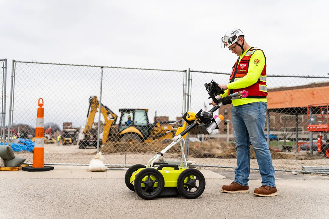
GPRS utility locating services utilize ground penetrating radar (GPR) and electromagnetic (EM) locating technology to locate, mark, and map existing underground infrastructure such as power lines, gas lines, pipelines, water lines, sewer lines, potential voids, and additional buried facilities and utility lines. This information is critical for projects where construction or excavation activities are planned to mitigate accidental utility strikes, plus keep your team and facility safe. GPRS delivers complimentary CAD utility site maps in PDF, KMZ, and SHP file formats, and can export your utility data into a wide variety of drawings, maps, and models to advance communication and collaboration on your project. All clients receive instant access to complete and aggregated site records in Sitemap® GPRS’ digital storage software and app, where data is geolocated, layered, and securely shareable.
Concrete Scanning Services
Concrete scanning is a non-destructive method to assess concrete using GPR to locate, identify, and mark utilities and objects such as rebar, post tension cables, beams, conduits, and piping embedded within concrete slabs and structures prior to anchoring, cutting, coring, and drilling. Concrete scanning ensures the safety of workers and prevents accidents by identifying potential hazards before any work occurs. Concrete markings can be 3D laser scanned to create a permanent record of the site, data can be delivered in 2D CAD drawings, 3D BIM models, and virtual site tours.
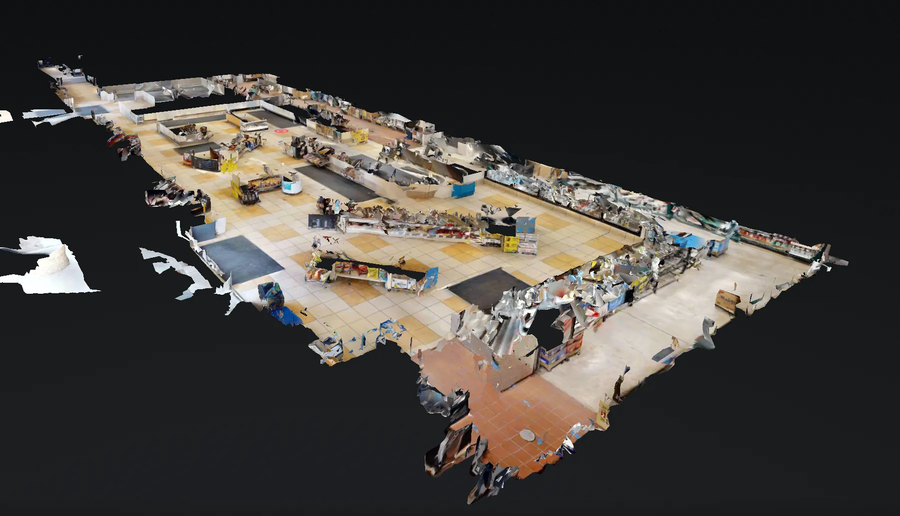
3D Laser Scanning Services
GPRS 3D laser scanning services document the exact architectural, structural, and MEP system layout and dimensions of existing telecommunication buildings, facilities, and sites. GPRS Project Managers use industry-leading Leica survey-grade laser scanners to capture 2-4 millimeter accurate existing site conditions in the form of a point cloud. Our in-house Mapping & Modeling Team can transform those point clouds into customized 2D CAD drawings, 3D BIM models, 3D mesh models, TruViews, and 3D virtual tours at any level of detail. 3D laser scanning is essential for the mapping and modeling of proposed implementation sites of telecommunication towers or telephone lines because it is a quick, accurate, and cost-efficient way to collect spatial data from the ground level. It is useful in finding ideal locations for telecommunication equipment (both the towers and paths), and its 3D modeling and topographical mapping abilities help to ensure that the infrastructure will work in relation to the rest of its environment. Additionally, even after successful telecommunication implementation, laser scanning is instrumental in troubleshooting and maintenance. Laser scanning is capable of determining the size and position of antennas on cell towers without surveyors needing to gain access to the tower. It can also be used to produce an inventory of antennas and telecommunication equipment.
Video Pipe Inspection Services
GPRS video pipe inspection services deploy robotic crawler CCTV cameras, lateral launch cameras, and push cameras to inspect and document water, sewer lines, and lateral pipelines to locate clogs, investigate cross bores, find structural faults and damage, and conduct lateral sewer line inspections. GPRS Project Managers deliver NASSCO-certified WinCan reports with the exact location, video, and photo of each defect, ranked by severity so you can plan for maintenance and repairs.
Leak Detection Services
GPRS specializes in all types of leak detection services, including municipal, industrial, and residential. Our Project Managers are leak detection specialists who utilize multiple technologies to locate your leak and the expertise to map and provide many other insights into your water distribution and/or fire suppression systems. GPRS does this by utilizing a variety of equipment paired with our industry-leading SIM (Subsurface Investigation Methodology) processes. The equipment and methods used include acoustic leak detectors, leak noise correlators, video pipe inspection (CCTV) cameras & sondes, ground penetrating radar, and electromagnetic locating, among others.
Read the Article: What are Best Practices for Pre and Post Directional Drilling Installations?


.webp)


Let's Get To Work
Schedule A Project


CUSTOM SERVICE PLANS

Scheduling

Pricing

Approach

mapping & Modeling
GPRS delivers the most up-to-date, accurate and comprehensive site data possible in the format required for your project. We provide complimentary KMZ and PDF maps with every utility locate we perform. Our Mapping & Modeling Team can create a wide variety of customizable maps and models, from a simple GPS-enabled map of your utility locate, to highly-detailed 2D CAD drawings and 3D BIM models, depending on your needs.
AS BUILT DRAWINGS
2D MAPS & 3D MODELS
SITEMAP® MOBILE APP

One Call Program

Public Property
Private Property

Embedment
CASE STUDY
SUPPORTING THE 5G EXPANSION
Recently, Ground Penetrating Radar Services was asked to assist in the site acquisition and design process for 189 small cell sites in Miami, Florida. GPRS Project Managers needed to locate all utilities within a 30’ radius around each proposed pole location. The project manager was able to provide paint on the ground, pin flags, pictures, and a site map of the utilities found with measurements from the curb to each of the underground utilities.

DISPATCHING AND LOCATING
For this job we were given all 189 small cell sites in one batch to complete as soon as possible. Given that we have team members nationwide and several in the Miami market we were up for the task. When our client released the proposed node locations, they sent the coordinates of the proposed node location along with any other pertinent information that would be needed in the post-utility locate report, map, and utility drawing. Our Operations and Deliverables team was able to create a custom service plan that addressed the specific project needs – including our final map/drawing. Our custom service plan allowed our team to mobilize, complete the underground locating and deliver a detailed report of our findings all within the requested timeline.
DELIVERABLES AND REPORTING
To ensure clear communication for these 5G sites, GPRS was able to deliver utility markings on the ground, pin flags, a Job Summary report, pictures of the site after the utility locating was complete, measurements from the curb to the utility and finally a map with that information overlaid onto a satellite image. After performing the locate, the Job Summary, pictures from the site and utility map are delivered to the client. This level of communication ensures that damage prevention is achieved and that there is clear communication about the location of underground facilities prior to design or excavation.

WHY GPRS?
Over the last two years we've been helping to streamline the design and installation of new 5G nodes. Although the 811 system can be utilized in the ROW there are many benefits to utilizing a private locating service as well. Clients are utilizing GPRS to increase utility locating accuracy, faster response time, finding utility depths, special reporting, and the consultative approach we take from being the leaders in the industry. Let’s get to work!
Case Studies


Related Articles


.webp)

