

.svg)
Privately owned and publicly operated EV charging stations continue to populate nationwide. Whether they are commercial EV charging stations owned by businesses or public charging stations owned by local governments, EV charging adoption is growing rapidly.
In 2016, there were 44,354 EV charging ports and 17,810 charging stations in the United States according to the U.S. Department of Energy.
As of March 2026, that number has more than quadrupled as there are over 270,000 charging ports and over 80,000 charging stations.
The Department of Energy claims the U.S. will need 28 million EV charging ports by 2030, growing the current infrastructure by a multiple of ten in only a few years.
Despite the exponential growth in EV infrastructure, there are rising concerns among EV drivers, installers, and managers.
What is the EV Charging Delivery Landscape?
Rising Demand for EV Charging Infrastructure
The usage of public EV charging ports reached an estimated 141 million sessions in 2025, which marked a 30% increase year-over-year.
The increase in EV adoption indicates a higher demand for EV charging infrastructure. However, in 2025, charging sessions increased by 34% while new charging ports only grew by 16%, according to a ChargePoint report.
Nationwide efforts are taking shape as federal programs develop a national EV charging infrastructure network.
The U.S. Department of Transportation (DOT) enacted the National Electric Vehicle Infrastructure (NEVI) Formula Program in 2021, where they allocated $5 billion for states to “strategically deploy electric vehicle (EV) chargers and to establish an interconnected network to facilitate data collection, access, and reliability.”
As the nation needs more charging stations at an increasingly faster pace, projects will require tighter timelines and higher reliability expectations to meet the demand.

Permitting Process
The installation of EV charging stations involves extensive permit requests.
Before installing anything, property managers must obtain the proper permits to avoid citations, fines, business closures, and public endangerment from improper practices.
There are different permits for residential and commercial projects. Account to workflow specialists, PermitFlow, the permitting process can take 1-4 weeks for residential projects and 4 weeks to multiple months for commercial, as it depends on the scope of work.
The permitting process for commercial buildings includes:
- Site assessments conducted by a qualified electrical contractor that assesses the electrical capacity and layout of the property
- Submitting detailed site plans like electrical schematics and load calculations to local government agencies
- Inspections that ensure the EV station meets building codes
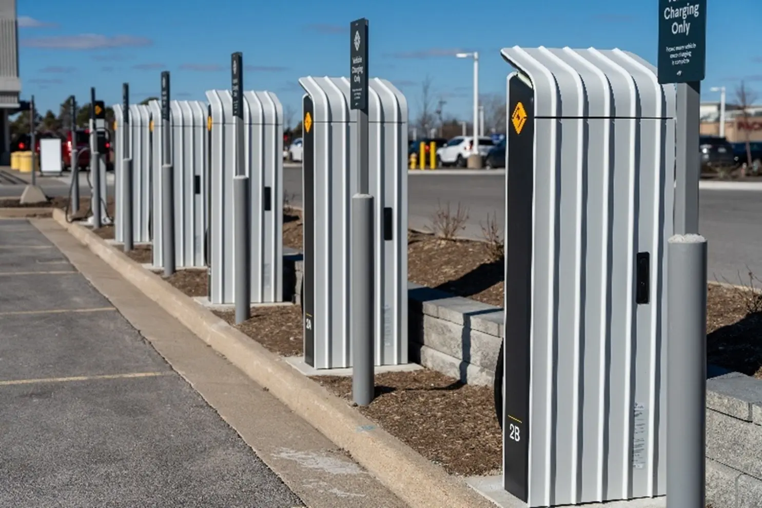
Commercial EV’s Intricate Construction Process
Once officials approve the permits, the installation process can begin.
Installing EV charging stations involves:
- Upgrades as needed to the existing electrical systems
- Running electrical conduit
- Installing protective bollards
- Mounting the chargers to walls or support structures
- Connecting the unit to the site’s electrical panel.
The process can take weeks to years, according to industry advocates like the Center for Sustainable Energy, depending on the scope of the job and how extensive the necessary upgrades are.
Cutting concrete, trenching, and directional boring is usually required for installation. Any time a project involves breaking ground, there is the possibility of striking utilities or other subsurface obstructions, especially if the utility information is outdated. According to Construction Dive, damage to buried utilities imposes more than $61 billion per year in waste and excess costs on communities.
Without accurate utility data, the chances of striking a utility line are very high, which can lead to massive delays, high repair costs, and potentially fatal injuries for workers.
Insufficient Grid Capacity Poses Risk
One of the biggest obstacles when installing EV chargers is the lack of grid capacity.
Many locations lack the electrical capacity needed to support EV charging stations. Because of this and the exponential rise in EV demand, building managers have no choice but to implement upgrades to electrical panels, transformers, and/or utilities to avoid missing out on the business of EV drivers. These upgrades are also very expensive and often slow to install.
The massive expansion of EV infrastructure is also affecting citywide grid systems. Uncontrolled charging during peak hours, like mornings and evenings, can strain electricity systems, leading to reliability issues.
However, there are initiatives in place like grid modernization efforts and the implementation of smart grid technologies to increase electrical capacity and use AI-based forecasting to monitor energy usage.
Mitigating for Unreliable EV Charging Performance
There is a rising concern among EV drivers regarding the reliability of public EV chargers. A recent study conducted by Harvard Business School analyzed 1 million EV charging customer reviews across North America, Europe, and Asia.
In the study, drivers mentioned coming across broken or malfunctioning equipment often. In the U.S. specifically, drivers claimed that charging stations were less reliable than gas stations, having an average of one in five chargers not working properly.
One way that the U.S. is combating the unreliability label placed on EV chargers is through a three-pronged approach stated by the Federal Highway Administration (FHWA) in February of 2023. They planned to address the issue by:
- Increasing the technical skills and qualifications required for electrical technicians working on Electric Vehicle Supply Equipment (EVSE)
- Requiring a charging station to be fully functional, connected, and available to recharge a driver’s vehicle at least 97% of the time
- Requiring the data for error codes and the duration of an outage during any unsuccessful charging sessions
How Can GPRS Support EV Infrastructure Projects?
GPRS offers a wide range of visualization services that make us a trusted resource in AEC industries.
The services GPRS Project Managers execute on job sites include utility locating, concrete scanning, reality capture, video pipe inspection, leak detection, and facility management via SiteMap® (patent pending).
Striking underground utilities near EV charging sites can cause delays, outages, and severe safety risks. GPRS Project Managers maintain 99.8% accuracy on underground utility scans, using complementary technologies like GPR and EM locators to precisely identify public and private utilities. This level of accuracy helps EV projects avoid strikes and stay on schedule.
Damaging a post tension cable can cost up to $30,000 to repair and lead to structural failure. GPRS concrete scanning provides 99.8% accuracy when locating post tension cables, rebar, and conduit. The Green Box Guarantee® confirms areas are clear of obstructions, allowing installers to cut confidently.
Inaccurate as builts create major project risks. GPRS uses LiDAR based 3D laser scanners to produce millimeter accurate point clouds that our in-house Mapping & Modeling team can convert into 2D or 3D deliverables. Reality capture also supports utility locating and concrete scanning by documenting marked out sites and creating models of the subsurface infrastructure. Accurate as-builts reduce miscommunications and rework for EV charging projects.
Cross bores can cause backups, pipe damage, and even explosions. NASSCO certified GPRS Project Managers use CCTV equipment to identify cross bores, along with pipe cracks and defects. All findings are communicated through NASSCO-compliant WinCan reports that help prevent new cross bores from forming during EV power line installations.
Cooling systems for high power chargers must avoid leaks to prevent system failures and fire hazards. GPRS pinpoints leaks by using advanced acoustic equipment and offer routine water loss surveys to maintain system efficiency.
All the data collected from GPRS’ core services are also delivered to our clients via SiteMap, our cloud-based infrastructure management platform. With SiteMap, clients can securely access all their subsurface utility data 24/7. And depending on the access level, clients can share valuable information with their teams and shareholders to make sure everyone is properly informed.
Since 2025, GPRS has added additional layers to the platform to enhance the user experience and house more valuable data. Those additional layers include:
- Sewer Layer: a single source of truth for wastewater and storm assets that include RTK geolocation accuracy and maps with full WinCan reports and in app video for each pipe segment
- Reality Capture Layer: securely stores all point clouds, virtual walkthroughs, and Revit models geospatially all in one place
- Augmented Reality: allows clients to walk their jobsite or facility and see their subsurface utilities in their physical space through the SIteMap Mobile App
How Does GPRS Assist with the Project Lifecycle of EV Installations?
Pre Construction Planning
Highly accurate subsurface utility maps and as builts help eliminate risk when planning any excavations or renovations.
Design Process
LiDAR based 3D laser scanners produce millimeter-accurate 2D and 3D models of sites to help ensure projects progress on time and safely.
Construction
Utility and concrete scanning results provide the information needed to avoid utilities, rebar, post tension cables, and conduit when installing chargers or renovating existing infrastructure.
Post-Construction
All utility, sewer, and reality capture data is at the client’s fingertips 24/7 via SiteMap for them to access and reference during any future projects on site.
CASE STUDY: GPRS Utility Locating Ensures Safety of Ohio EV Charger Installation
The 99.8% underground utility scans conducted by GPRS ensured the safe installation of electric vehicle chargers at an Ohio service station.
Problem
- An EV charging station installer was hired to install chargers at a service station in Cambridge, Ohio
- There were no accurate as-builts of the buried infrastructure on the site
- The installation needed to be completed with minimal disruption to the station’s operations
Solution
- GPRS utilized electromagnetic (EM) locating and ground penetrating radar (GPR) to locate and map the utilities on-site
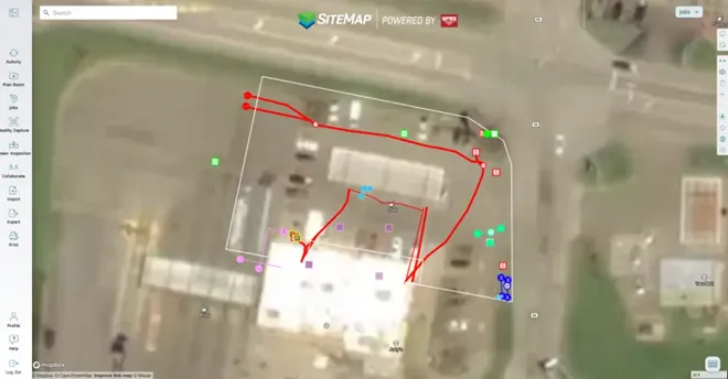
- The accurate, actionable data was uploaded to SiteMap® (patent pending), GPRS’ infrastructure mapping, and construction and facilities project management software application
- The GPRS Project Manager conducted their investigation without disrupting the service station’s operations
Benefits
- The installers were able to complete their work without striking any buried utilities, ensuring the safety of everyone on-site and the success of the project
- Services at the station were able to continue without the disruptions that would have occurred due to destructive and expensive potholing
- SiteMap ensured the entire project team had 24/7, secure access to the information they needed to avoid costly and potentially dangerous mistakes
Let us help power your projects with accurate, actionable data as you continue to power the future.
What can we help you visualize?
FREQUENTLY ASKED QUESTIONS
What GPRS deliverables come with EV charging projects?
Some deliverables clients can expect to receive when working with GPRS on EV charging infrastructure projects are:
- High-resolution utility as-builts (PDF or KMZ files)
- Above and below-ground facility and infrastructure mapping
- Conceptual site models (CSM)
- Concrete markings and mapping
- 2D CADD drawings
- 3D models
- Virtual walkthroughs
- As-built creation and existing conditions documentation
- NASSCO-compliant WinCan reports
- Routine water loss surveys
How do contractors and subcontractors utilize SiteMap?
Contractors use SiteMap to access information directly on the job site. They can view utility locations, reports, and drawings on a tablet or laptop.
Example: Before digging, a contractor can open SiteMap to check where utilities are located. They can also use My Dig Board in SiteMap to draw layouts, mark dig zones, plan access routes, and update plans so everyone knows exactly where to excavate.
Having this information in the field saves time and keeps workers safe.
With the role-based access, Subcontractors can use SiteMap to see only the information they need for their jobs. This helps them understand where utilities and structures are located without confusion.
Example: A subcontractor installing electrical lines can look at SiteMap to see nearby utilities and avoid conflicts with other trades.
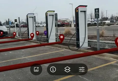
How does the SiteMap Augmented Reality feature work onsite?
The Augmented Reality feature shows your subsurface utilities in real space with 99.8% accuracy on your phone or tablet. It can only be accessed through the mobile app.
The convenience of viewing your utilities in a physical space allows for enhanced clarity during site walks and reduces risk while digging.
What is SIM?
Subsurface Investigation Methodology (SIM) is a standard operating procedure and set of professional specifications that work as a guide for utility locating experts when scanning for buried utility lines. All GPRS Project Managers are required to achieve SIM 101 certification, which requires 80 hours of hands-on training in a classroom setting and 320 hours of mentorship in the field. For reference, the American Society for Nondestructive Testing’s (ASNT) minimum training recommendation includes eight hours for training and 60 hours practicing GPR to achieve NDT Level 1 certification in ground penetrating radar (GPR) scanning.
SIM requires the use of multiple, complementary technologies, like GPR scanning and electromagnetic (EM) locating, when locating buried utilities or scanning a concrete slab.