

.svg)
In June of 2025, GPRS introduced the SiteMap® Reality Capture Layer, the latest evolution of providing our clients with complete visualization of their built world.
GPRS Reality Capture services do exactly that: capture your reality by way of accurate existing conditions documentation. It is one of the core services provided by GPRS Project Managers. With the use of state-of-the-art, LiDAR-based 3D laser scanners, GPRS Project Managers can develop millimeter-accurate as-built documentation.
SiteMap is GPRS’ cloud-based infrastructure management platform. Its Geographic Information System, or GIS, provides users with a customizable interface to manage their built world in a geospatially accurate digital environment.
SiteMap is well-known for securely storing underground utility data. If a GPRS Project Manager performs 99.8% accurate underground utility scans, the results are uploaded to SiteMap for the client to analyze at a moment’s notice. Depending on their access level, they can store site data for multiple locations and seamlessly share it with their team across the country.
Now, clients can do the same with 2-4 mm accurate reality capture data and deliverables with the SiteMap Reality Capture Layer.
WHAT IS SITEMAP’S REALITY CAPTURE LAYER?
The SiteMap Reality Capture Layer keeps all your 3D laser scanned data in one secure platform. The user-friendly interface gives you the ability to analyze your reality capture data with ease. When combining this with underground utility scan data and the SiteMap Sewer Layer, you can visualize your built world in the palm of your hand.
WHAT KIND OF DELIVERABLES ARE INCLUDED?
POINT CLOUD
Point cloud data refers to the data points collected for a given geographical area, terrain, building, or space. LiDAR-based laser scanners or photogrammetry cameras create point cloud data points through the scanning process.
Point clouds provide powerful and dynamic information for a project. By representing spatial data as a collection of X, Y, and Z coordinates, point clouds deliver large datasets that AEC professionals can mine for information.
CAD technicians, like the GPRS Mapping & Modeling team, transform point clouds into customized deliverables used for visualization, analysis, design, construction, renovation, prefabrication, and facility modifications. These deliverables include 2D CAD drawings, 3D models, and interactive virtual walkthroughs.
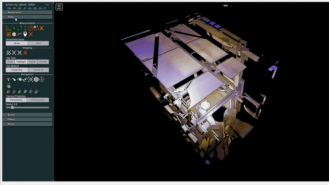
When viewing point cloud data on the Reality Capture layer, there is a plethora of tools you can use to customize your view and analyze the data in great detail. Some of the tools include:
- Distance Measurement
- Height Measurement
- Angle Measurement
- Volume Measurement
- Polygon Clipping
- Volume Clipping
- Customizable Node Size
- Customizable Splat Quality (Detail of the Model)
- Customizable Backgrounds
- Customizable Navigations / Perspectives
- & much more!
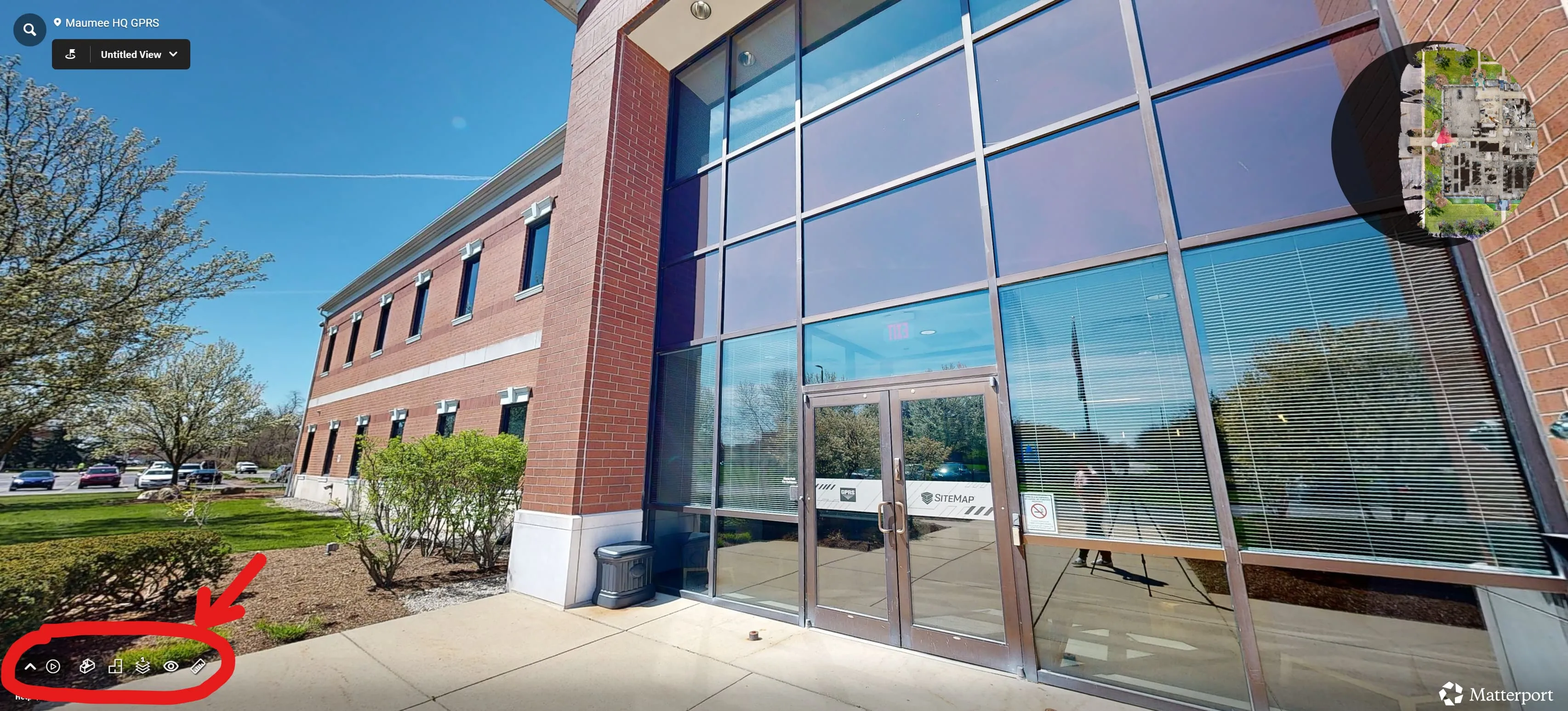
VIRTUAL WALKTHROUGH
GPRS reality capture specialists use professional-grade 3D cameras to capture 360° images and data points with remarkable accuracy to create immersive and interactive walkthroughs of facilities.
Like point cloud data, there are also a series of tools you can use to further analyze the data when viewing the virtual walkthrough on the Reality Capture layer. These tools include:
- Exploring the 3D Space: clicking through the virtual landscape of your property allowing you to do virtual walkthroughs from your laptop or mobile device
- Dollhouse View: a complete view where you can view and analyze the entire property, similar to a child with a dollhouse
- View Floor Plans: the complete birds-eye view of your property
- Floor Selector: view all or one floor at a time if your property has more than one
- Measurements: place points anywhere you choose across the model to obtain accurate measurements of that specific area
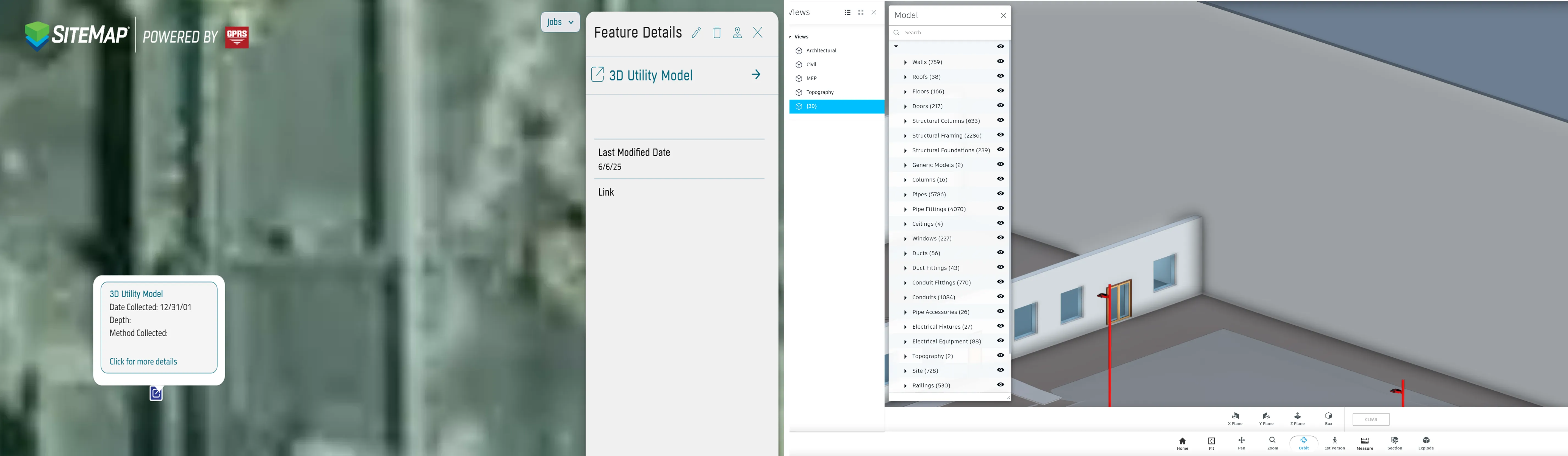
REVIT
Revit is a building information modeling (BIM) software used by AEC professionals to create, edit, and review 3D models of buildings and infrastructure in exceptional detail. Autodesk Revit software expedites the design of a building or structure and its components in 3D, annotates the model with 2D drafting elements, and stores building information modeling details.
The SiteMap Reality Capture Layer gives you access to your Revit models within the platform. Once you open the model, the platform presents a wealth of tools to help you gain a better understanding of your built world. Some of these tools include:
- 1st Person Point of View
- Measuring Tools
- Explode (disassembling the model)
- Media Brower (hide certain aspects of the model)
- 3D View
- Topographical View
- MEP View
- Civil Engineering View
- Architectural View
- & more!
WHAT ARE THE BENEFITS OF USING SITEMAP REALITY CAPTURE?
GPRS Director of Reality Capture, Matt Mikolajczyk, stated the following when asked what the greatest benefits of the SiteMap Reality Capture Layer are.
“It's all in one place and it's geolocated, so it's on top of the building that it belongs to. With Google Drive, Procore, or Box, there’s all these other file storage solutions you can put all in one place. Ours is different because it's geospatially all in one place.”
When asked how SiteMap Reality Capture is different from similar GIS platforms, Mikolajczyk said:
“I think there are other tools like SiteMap, but for a lot of those tools, they still rely on the end user to link them into the platform. That's another benefit. We do that as part of our service. We put [your as-built information] in this platform for them, so they don't have to manage it. They can just get in and use it.”
HOW TO OPERATE THE SITEMAP REALITY CAPTURE LAYER
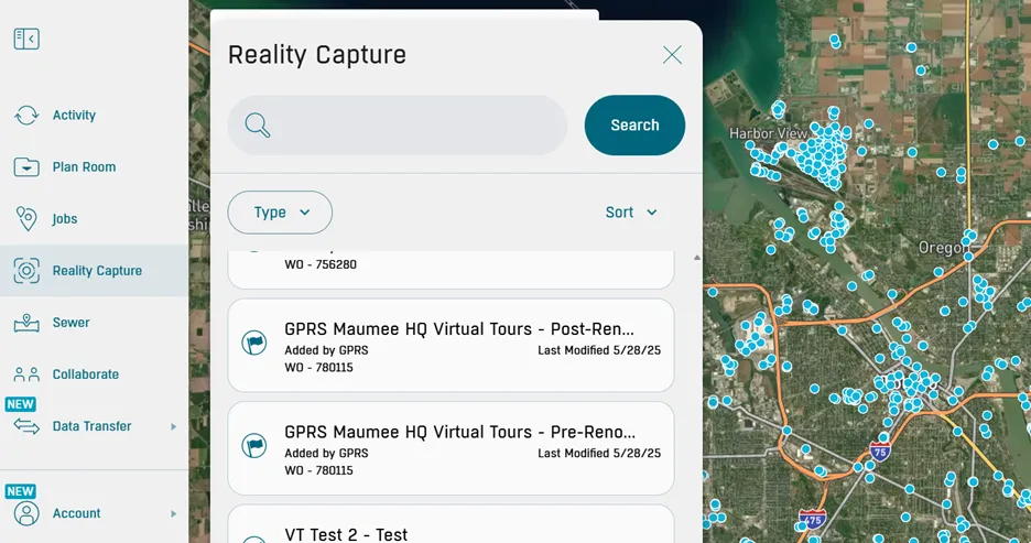
Once you login to the SiteMap platform, you will find the Reality Capture Layer in the toolbar on the left-hand side.
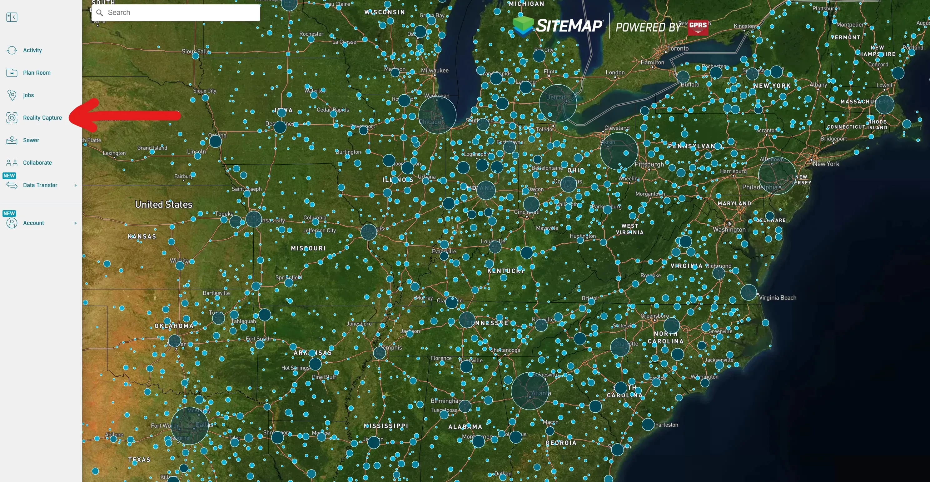
You can locate your job by doing any of the following:
- Entering your job’s Work Order Number (WO#) or company name into the Reality Capture Layer search bar
- Entering the address of your site in the main search bar

The same can be done on the “Jobs” tab, also in the left toolbar, but the Reality Capture deliverables won’t populate there.
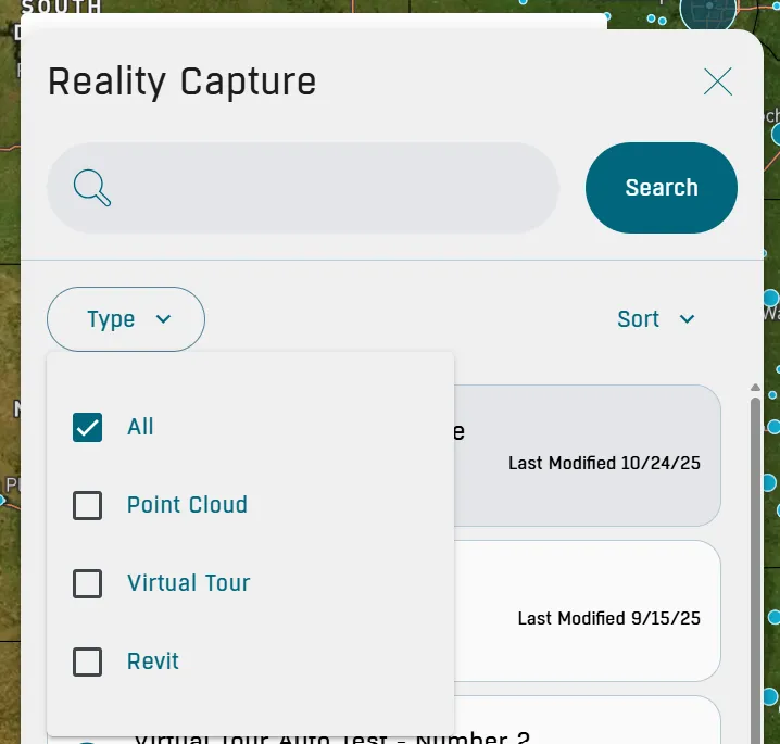
If you entered your WO# into the Reality Capture Layer search bar, you also have the option to filter your search based on the deliverable type.
When your data populates, you can analyze them in detail from inside SiteMap, rather than going to different platforms or file types for each deliverable.
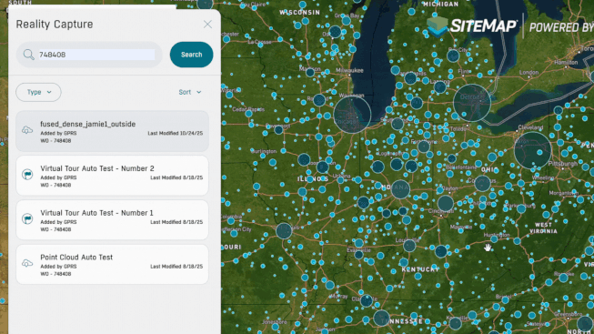
If you search for your address in the main search bar instead, the site will take you to the site’s geolocation on the map.
There will be icons located above the areas or structures that represent certain reality capture deliverables.

- Point Cloud Data
.webp)
- Virtual Walkthroughs

- Revit model / external links
With all your data in one place, projects can progress with ease, thus making the decision-making process simpler and preventing rework or delays.
HOW CAN I UTILIZE THE SITEMAP REALITY CAPTURE LAYER?
All you have to do is ask! GPRS customers with Project, Pro, and Team access can have their Reality Capture data uploaded directly into SiteMap upon the completion of the scanning and modeling process. Additionally, if your previous jobs involved reality capture, reach out to us and we’d be happy to include that in your SiteMap.
What can we help you visualize?
FREQUENTLY ASKED QUESTIONS
WHAT IS LIDAR?
LiDAR (Light Detection and Ranging) is a remote sensing tool that builds accurate 3D models of objects and surfaces. Instead of using radio waves like radar, LiDAR sends out laser pulses from a scanner. These light pulses bounce off objects, and the system measures how long they take to return. This helps calculate exact distances and shapes. It creates detailed three-dimensional data about an object.
HOW IS 3D LASER SCAN DATA PROCESSED?
Once a site is scanned, we process the raw point cloud data by combining individual scans. We remove unwanted noise and convert the data into usable formats like 2D drawings or 3D models. The level of detail depends on the project’s needs, ranging from basic visuals to complex models. GPRS follows a structured workflow focused on accuracy, teamwork, and planning. We ensure efficient project execution. Our deliverables are high-quality and tailored to each client's needs.
WHAT DELIVERABLES CAN GPRS PROVIDE?
We can deliver 3D laser scan data in many formats, including:
- Point Cloud Data (Raw Data)
- 2D CAD Drawings
- 3D Non-Intelligent Models
- 3D BIM Models
- TruView (previously known as JetStream) Viewer
We can also deliver the following customizable deliverables upon request:
- Aerial Photogrammetry
- Comparative Analysis
- Deformation Analysis
- Digital Drawings of GPR Markings
- Floor Flatness Analysis/Contour Mapping
- New Construction Accuracy Analysis/Comparative Analysis
- Point Cloud Modeling Training Webinars
- Reconciliation of Clients 2D Design Drawings
- Reconciliation of Clients 3D Design Model
- Structural Steel Shape Probability Analysis
- Template Modeling
- Volume Calculations
- Wall Plumb Analysis