

.svg)
GPRS Project Manager Colton Carney once again proves that you never know where existing conditions visualizations may take you. He recently helped C3 Presents set the stage for one of the NFL’s biggest events - the NFL Draft at Acrisure Stadium in Pittsburgh, Pennsylvania.
In May of 2024, the NFL’s Fan Engagement & Major Events Advisory Committee selected the Pittsburgh Steelers to host the 2026 NFL Draft.
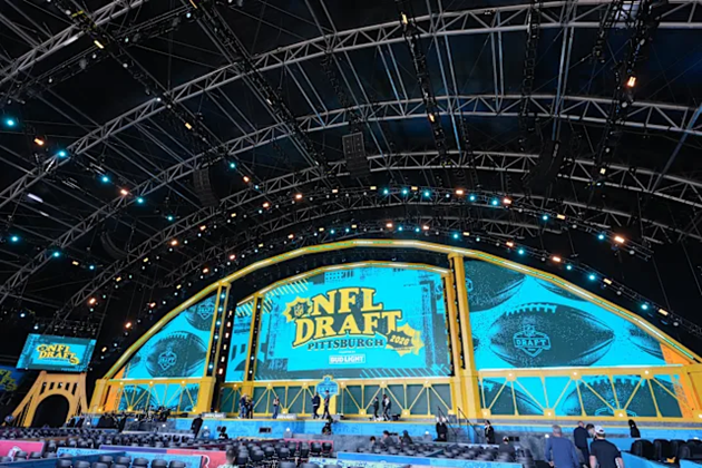
To host an event of this caliber, the event organizers needed to transform the 24-year-old stadium inside and out, so it can accommodate the players, families, and fans.
C3 Presents was hired to put together the green rooms within the stadium for the soon-to-be draft picks and their families to sit and wait to hear their names called. They also managed the hanging of large banners and needed to know the layout of piping runs before installing them.
To plan out the stadium’s draft day makeover, they needed precise measurements and models of the space. That is where GPRS came in.
In February of 2026, C3 Presents tasked GPRS Project Manager Colton Carney with scanning the inside of the Steelers’ home stadium, despite his allegiance to their AFC North rivals, the Cleveland Browns.

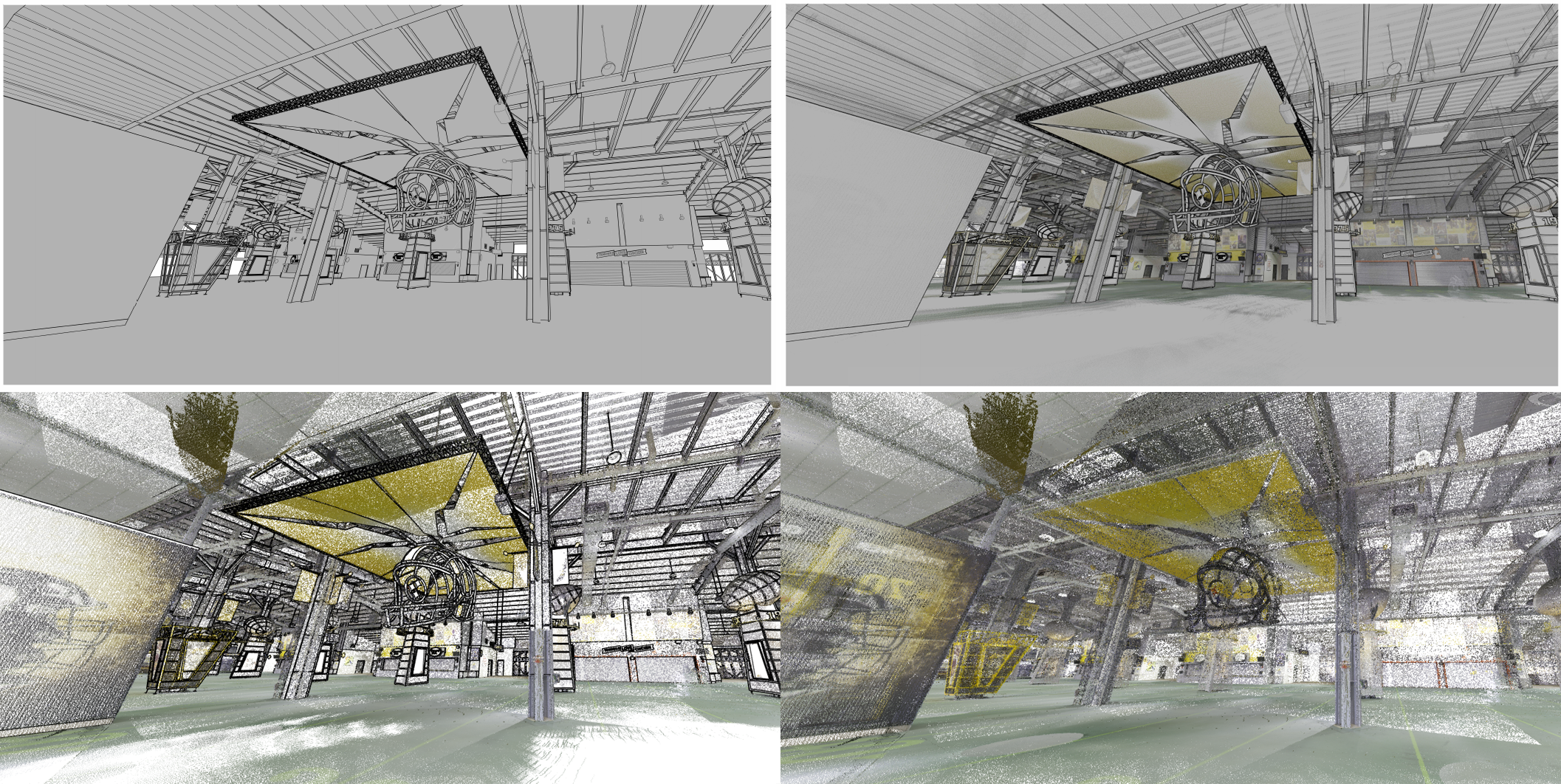
GPRS Reality Capture Project Managers utilize LiDAR-based 3D laser scanners to scan everything from skyscrapers to dinosaur skeletons and document the site’s existing conditions.
“It was approximately 15,000 square feet of scanning, and we did all color scans for that. Roughly 80 to 90 scans total,” Carney explained. “That entails capturing the data but also collecting high-def pictures.”
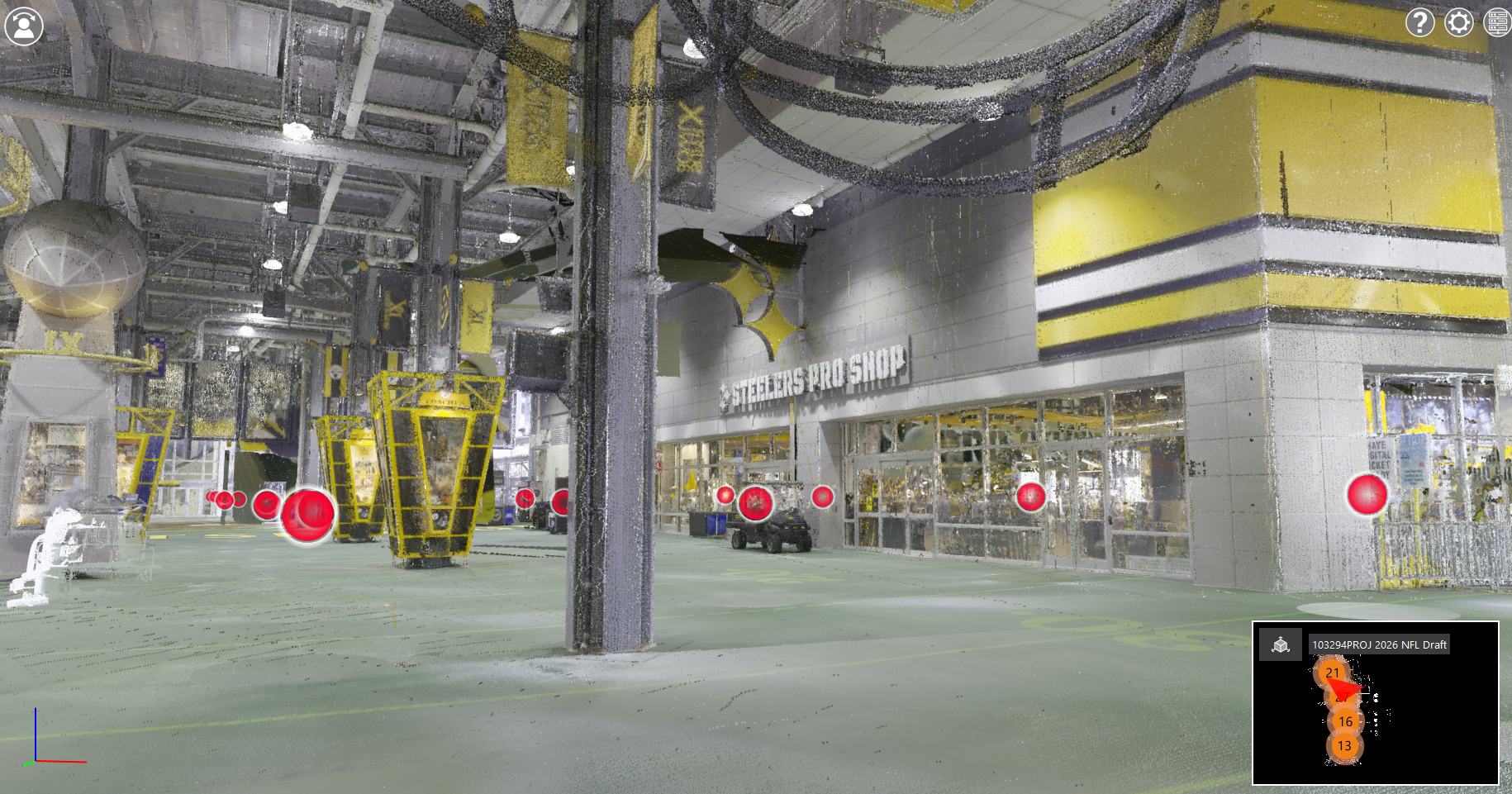
Each scan documented the stadium’s interior with millimeter accuracy and is automatically translated into a point cloud file.
Once Carney finished scanning the area, the point cloud was then converted into 2D and 3D deliverables by GPRS’ in-house Mapping & Modeling team.
“The modeling itself was focused on the floors, the ceilings, the walls, doors, windows, stairs, elevators, ramps, etcetera,” Carney explained.
C3 Presents received a collection of deliverables, including:
The precise drawings and models let C3 Presents make the best possible decisions throughout the project and ensure the location is ready for Draft Day. If only NFL executives could have this much certainty when drafting who they hope to be their next batch of franchise players.
In Carney’s four years as a GPRS Project Manager, he could confidently say this was a job he’ll never forget.
“I thought it was an awesome experience,” Carney explained. “I didn’t know that what we do every day was even involved in that process. But this is definitely the coolest job that I've done.”
Months later, while watching the 2026 NFL Draft, Carney had a whole new perspective watching this annual sport event he had been watching for many years.
“It's pretty awesome to see the players and their families knowing that that the entire layout and floor plan of what they came up with for them and say it was from the data that we had collected that day,” Carney explained.
From stadiums to sewer lines, GPRS Visualizes the Built World, above and below-ground.
What can we help you visualize?
FREQUENTLY ASKED QUESTIONS
WHAT IS LIDAR?
LiDAR (Light Detection and Ranging) is a remote sensing tool that builds accurate 3D models of objects and surfaces.
Instead of using radio waves like radar, LiDAR sends out laser pulses from a scanner. These light pulses bounce off objects, and the system measures how long they take to return. This helps calculate exact distances and shapes. It creates detailed three-dimensional data about an object.
Learn more about LiDAR and how GPRS utilizes LiDAR laser scanners here.
WHAT IS POINT CLOUD DATA?
Point cloud data is the term for data points collected by LiDAR-based laser scanners.
Each point stores X, Y, and Z coordinates for visible surfaces like walls, doors, and MEP components.
The data points are used by GPRS’ in-house Mapping & Modeling team to create 2D and 3D deliverables for clients.
Learn more about GPRS’ Point Cloud Services here.
WHAT IS SIM?
Subsurface Investigation Methodology (SIM) is a standard operating procedure and set of professional specifications that work as a guide for utility locating experts when scanning for buried utility lines. All GPRS Project Managers are required to achieve SIM 101 certification, which requires 80 hours of hands-on training in a classroom setting and 320 hours of mentorship in the field. For reference, the American Society for Nondestructive Testing’s (ASNT) minimum training recommendation includes eight hours for training and 60 hours practicing GPR to achieve NDT Level 1 certification in ground penetrating radar (GPR) scanning.
SIM requires the use of multiple, complementary technologies, like GPR scanning and electromagnetic (EM) locating, when locating buried utilities or scanning a concrete slab.
WHAT REALITY CAPTURE DELIVERABLES CAN GPRS PROVIDE?
GPRS can deliver point cloud data in many formats, including:
We can also deliver the following customizable deliverables upon request:
- Aerial Photogrammetry
- Deformation Mapping
- Digital Drawings of GPR Markings
- Floor Flatness Analysis / Contour Mapping
- At-Depth Modeling
- Native Modeling
- New Construction Accuracy Analysis/Comparative Analysis
- Point Cloud Modeling Training Webinars
- Reconciliation of Clients 2D Design Drawings
- Reconciliation of Clients 3D Design Model
- Structural Steel Shape Probability Analysis
- Template Modeling
- Volume Calculations
Schedule a service with our Reality Capture Project Managers here.