

.svg)
How Much Does Private Utility Locating Cost?
GPRS Private Utility Locating Costs Explained
When it comes to the cost of utility locating, the most important thing to know is this: with GPRS, you only pay for what you need, and investing in accurate utility locating services saves you far more than it costs.
You can always count on GPRS for straightforward, upfront utility locating pricing built around your project goals and timeline, so you never pay for services you don’t need.
GPRS tailors every utility locating quote by project scope because every building and site are different. Utility locating pricing depends on several factors, including:
- Soil conditions
- Site size
- Utility depth
- Number of utilities present
- Night/weekend work
- Level of detail required
- Deliverables required
GPRS provides pricing based on your specific site and project needs, not a one‑size‑fits‑all rate.
What You Get with Every Utility Locate
GPRS Project Managers locate, mark, and map all subsurface utilities using ground penetrating radar (GPR) and electromagnetic locating (EM) technology prior to excavation to help prevent strikes, protect your crew, and avoid costly damage and delays.
Comprehensive Subsurface Utility Detection
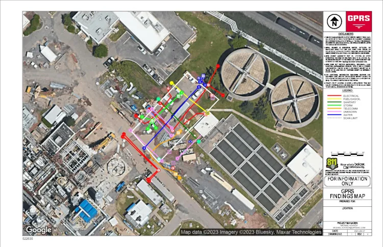
You will receive on site field markings with spray paint and/or pin flags, color-coded to American Public Works Association standards, plus utility maps to give your team a clear understanding of the exact location, depth, and layout of all underground utilities on your job site, including:
- Electric power lines, cables, conduit and lighting cables
- Gas, oil, steam, petroleum, and gaseous materials
- Communication, alarm or signal lines, cables or conduit
- Potable water
- Reclaimed water, irrigation, and slurry lines
- Sewers and drain lines
- Underground storage tanks
- Abandoned lines
- Unknown utilities
- Manholes & well heads
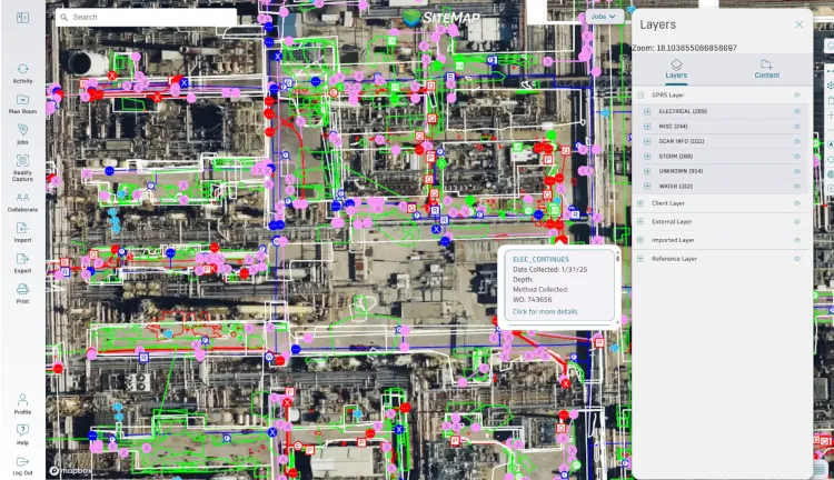
CAD/BIM Outputs Delivered in SiteMap®
All data is delivered through SiteMap®, GPRS’ secure, cloud‑based GIS platform and mobile app, providing easy access to 99.8% accurate utility locates and a full suite of digital deliverables:
- Job Summary Report
- Layered, interactive utility maps
- PDF and .KMZ formats
- Point clouds captured via LiDAR laser scanners
- 2D CAD drawings
- 3D BIM models and CSM models
- 3D Virtual Tours
Why Professional Utility Locating Matters
Accurate utility locating helps your team to:
- Avoid costly strikes and delays
- Keep your crew and site safe
- Stay compliant
- Prevent change orders and rework
- Keep your project moving confidently and on schedule
If you share a few details about your site, we can provide a fast, accurate quote for utility locating and mapping services and help you choose the most cost-effective utility loctating solution.
Why Accurate Utility Locating is Essential for Damage Prevention
Utility locating services are significantly less expensive than the cost of striking a utility line.
A white paper published in April 2023 by the Infrastructure Protection Coalition (IPC) highlights major failures in the nation’s damage prevention system used to protect the public and prevent damage to underground utility lines. These failures are responsible for over $30 billion in annual societal and utility line damage costs, and an additional $61 billion in annual waste and excess costs.
The Common Ground Alliance 2024 DIRT Report, the only comprehensive accounting of buried infrastructure damages in North America, found that 9 of the top 10 known root causes of utility damages occur during utility work itself. This means that the very activities intended to install or maintain utilities are often the ones most likely to damage existing buried lines when locating is inaccurate.
It is important for general contractors and engineers to carefully plan and complete work with an accurate utility locate and map. By partnering with GPRS for accurate utility locating, your team can prevent costly outages, injuries, delays, and downtime, protecting your people, your schedule, and your budget.
Do You Need Both Public and Private Utilities Located?
Yes, you do. Both public and private utilities need to be accurately located and mapped to ensure safety, avoid costly repairs, and prevent service outages. Public utility locators (811) mark registered lines up to the meter, while private utility locators can both verify your 811 locates, and find service lines beyond the meter that are often unmapped and dangerously forgotten.
More than 65% of all buried utility lines on any given site are unregistered/private utilities that 811 does not locate.
Private utilities are utilities which extend beyond service meters or public utilities, often on to privately owned property. Examples of private utilities can include electrical feeders and gas mains running through parking lots or to critical facilities such as hospitals or fire stations. They can also include lines running to and from substations, heavy industrial facilities, and refineries. These utilities would be owned and maintained by the property owner, placing them outside of the jurisdiction of public utility locating companies.
GPRS: The Most Accurate Utility Locating Team in the Industry
When you hire GPRS, you’re hiring highly trained SIM-certified specialists with over three times the training and hands on experience required by most providers.
With GPRS as your partner, you gain the field verified data and expert support you need to eliminate guesswork, reduce risk, and keep your project on track. No matter the complexity of your site, we deliver the clarity needed to make safe, informed, compliant decisions, from planning through execution.
Learn more about GPRS Utility Locating services.
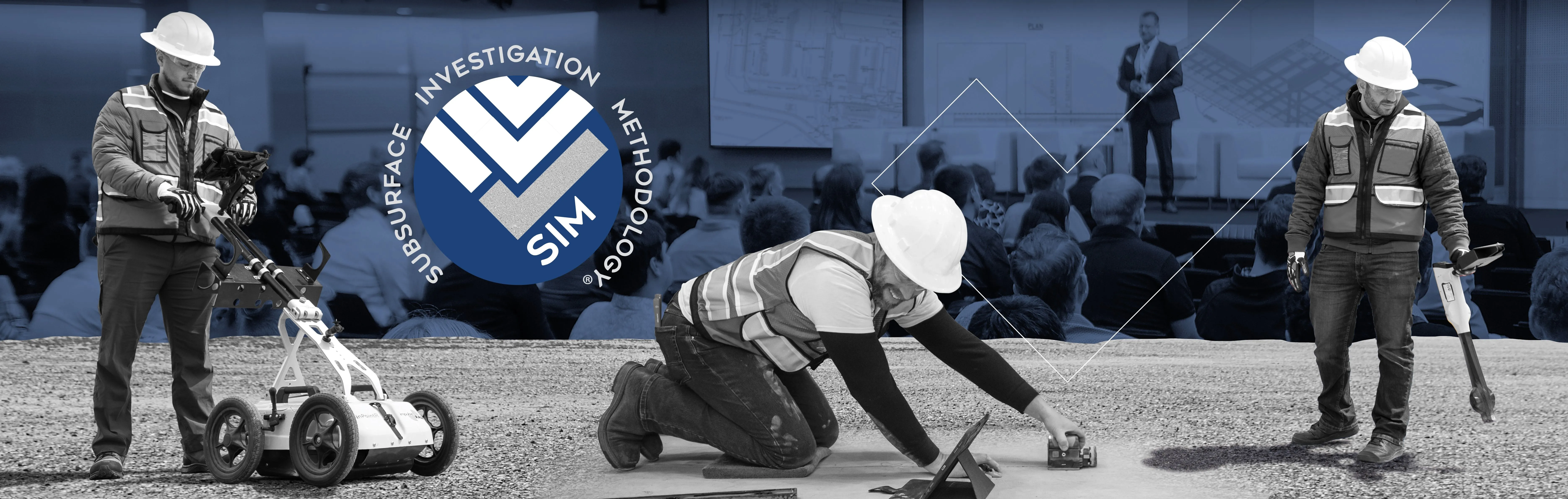
What is SIM Certification?
SIM certification is the rigorous training and qualification process GPRS Project Managers undergo in Subsurface Investigation Methodology (SIM), the industry’s most advanced standard for utility locating and subsurface investigation.
SIM is a structured, repeatable process designed to ensure maximum accuracy and safety when locating underground utilities or scanning concrete.
What SIM Certification Involves
To become SIM certified, a GPRS Project Manager must complete:
- 320 hours of mentored field training
- 80 hours of classroom training (hands on and curriculum based)
This far exceeds typical industry recommendations, which call for only 8 hours of classroom work and 60 hours of practice for Level 1 GPR certification.
What SIM Certification Ensures
A SIM certified GPRS Project Manager is trained to:
- Use multiple technologies (GPR + EM locators, and other complementary technologies) to cross verify findings
- Follow a step by step, repeatable process for data collection
- Adhere to a detailed SIM checklist to ensure accuracy in every situation
- Be prepared for unique, real-world scenarios
Why It Matters to Customers
Choosing a SIM certified GPRS Project Manager means you get:
- 99.8% accurate utility locating & mapping
- Reduced risk of utility strikes, delays, and costly rework
- Consistent, repeatable results across every project
- Safety focused, highly trained professionals
GPRS Project Managers have maintained a 99.8% accuracy rate in utility locating since 2017.
Learn more about Subsurface Investigation Methodology (SIM).
Industries GPRS Serves for Utility Locating
Healthcare & Hospitals
If you operate a hospital, clinic, surgical center, nursing home, lab, or pharmaceutical facility, you’re likely renovating, expanding, or adding new equipment regularly. You rely on uninterrupted power, water, and communications, so we locate your underground utilities to help you avoid service outages, reduce risk, and keep patients and staff safe during construction. Learn more about utility locating for Healthcare facilities.
Higher Education & K–12 Schools
Whether you manage a university campus, college, or school district, your facilities frequently undergo retrofits, construction, and infrastructure upgrades. We help you verify and map subsurface utilities, so your projects move forward safely and without unexpected delays. Learn more about utility locating for schools, universities, colleges, and campuses.
Data Centers
If you manage an enterprise, colocation, cloud, hyperscale, edge, or modular data center, you know a single utility strike can cause catastrophic downtime. We provide precise utility locating to protect your critical power and fiber lines during new builds, expansions, and retrofits so uptime stays uninterrupted. Learn more about utilty locating for data centers.
Manufacturing, Industrial & Agricultural Facilities
Plants, factories, and industrial sites constantly update production lines, equipment, and infrastructure. We help you locate underground power feeds, process piping, communications, gas, and water lines so your upgrades and installations stay on schedule and safe. Learn more about utility locating for facilities.
Telecom
Telecom networks depend on extensive underground fiber, conduit, power feeds, and communication lines that must remain active and protected during upgrades and new installations. Whether you're expanding fiber routes, installing 5G infrastructure, or upgrading network capacity, accurate utility locating helps you avoid strikes, prevent service outages, and keep projects on schedule. Learn more about utility locating for the telecom industry.
Oil & Gas
Oil and gas facilities depend on extensive underground infrastructure, including pipelines, flow lines, power feeds, communication cables, and control systems, that must be protected during maintenance, expansions, and new construction. Accurate utility locating helps your team avoid damaging critical lines, prevent shutdowns and environmental incidents, and keep high risk operations running safely and efficiently. Learn more about utility locating for oil and gas facilities.
Transportation & Infrastructure
Airports, railways, transit systems, ports, and DOT projects depend on complex underground networks. We help you map and avoid buried utilities so you can prevent strikes, maintain public safety, and keep major infrastructure projects on time. Learn more about utility locating for transportation and infrastructure.
Power Transmission, Distribution & Generation + Renewable Energy
Whether you're working on transmission lines, distribution networks, substations, power generation facilities, or building solar, wind, or EV charging infrastructure, you need accurate subsurface data to work safely. We locate underground utilities, grounding grids, duct banks, and conduits so you can trench, install foundations, and expand energy systems without risking outages, delays, or costly strikes. Learn more about utility locating for the power industry.
Real Estate Development & Commercial Property Management
Developers, landlords, and CRE teams rely on accurate utility locating to protect investments, speed up development, and reduce liability. Whether you’re doing due diligence, preconstruction planning, or a major redevelopment, we help you understand exactly what’s underground so you can build with confidence.
Public Works & Municipalities
City engineers, public utility districts, parks departments, and municipal campuses depend on accurate utility maps for capital improvement projects. We help you avoid service disruptions and keep critical community operations running smoothly.
Defense & Government Facilities
If you’re managing a military base, federal complex, or secure government site, precision and safety are non-negotiable. We help you locate underground utilities before construction or system upgrades so you can maintain security and avoid outages. Learn more about utility locating for government and defense.
Hospitality & Entertainment
Hotels, stadiums, arenas, theaters, and convention centers renovate frequently, and you rely on continuous power, water, and communications to serve guests and events. We help you avoid outages and protect your operations while work is taking place. Learn more about utility locating for hospitality and entertainment projects.
Historic Preservation & Adaptive Reuse
If you're restoring or converting an older property, you may be dealing with undocumented renovations and abandoned or unknown utilities. We help you safely locate aging electrical, gas, water, and sewer lines so your crews can work without damaging historically significant structures. Learn more about utility locating for historic preservation and adaptive reuse.
Water & Wastewater Treatment Plants
Your facilities contain dense, overlapping piping systems, chemical feeds, high voltage power, and control networks. We give you precise subsurface utility maps that support upgrades, expansions, and emergency repairs, without causing service disruptions. Learn more about utility locating for water and sewer projects.
Environmental Due Diligence
Accurate subsurface data is critical during Phase II environmental assessments. GPRS utility locating identifies underground utilities, UST components, and other subsurface features so you can clear soil borings, install vapor pins, and drill safely without risking damage. Our custom utility CAD maps protect existing infrastructure, while Conceptual Site Models (CSMs) help reveal potential contaminant migration pathways and guide informed next steps in your investigation. Learn more about utility locating for environmental due diligence.
Retail & Restaurants
If you manage retail spaces or restaurants, frequent remodels, kitchen upgrades, or tenant improvements require safe utility avoidance. We help you identify underground water, sewer, grease, gas, and electrical lines so your operations stay open and productive. Learn more about utility locating for retail and restaurants.
Airports & Aviation
From airfields to terminals and hangars, you operate above complicated underground networks, fuel lines, comms, runway lighting, stormwater, and power. We provide the accurate utility locating you need before construction, signage installation, lighting upgrades, or pavement work to prevent interruptions and safety risks. Learn more about utility locating for airports and aviation.
Reasons to Choose GPRS for Utility Locating Services
When you choose GPRS, you’re choosing accuracy, safety, and confidence on every project. From transparent pricing to unmatched SIM certified expertise, our team is committed to delivering detailed utility location field markings and maps that you need to plan, design, dig, and build without unexpected setbacks.
Utility locating is an investment that protects your people, your budget, and your schedule, and with GPRS, you can move forward knowing your site has been mapped with industry leading precision.
GPRS is the nation’s leading above and below-ground existing conditions visualization company, delivering unmatched utility locating accuracy through advanced technology and SIM-certified Project Managers to help our clients Visualize the Built World®.
Contact GPRS for utility locating pricing, and let us help you complete your project safely, efficiently, and with total confidence.