.svg)
Facilities
.avif)

GPRS is a leading provider of utility locating, concrete scanning, 3D laser scanning, video pipe inspection, and leak detection services, delivering reliable, high-quality data that can be used to make decisions about every facet of your facility and operations. GPRS services can help clients throughout the entire lifecycle of a project, from pre-planning to design and construction, through operations and maintenance.
GPRS has worked closely with many different types of facilities, including pharmaceutical facilities, industrial facilities, chemical facilities, manufacturing facilities, power plants, distribution facilities, airports, refineries, and more.
When it comes to facility management, every decision you make can cost time, money, and even lives. GPRS is in pursuit of a world with 100% subsurface damage prevention. Our 99.8% accuracy rate for ground penetrating radar services (GPR), utility locating services, utility mapping services, and concrete scanning services will locate critical targets like underground utilities, post tension cables, rebar, conduits, underground storage tanks (USTs), and more to help keep your project on time, on budget, and safe. Our NASSCO-certified CCTV video pipe inspection & leak detection services find pipe defects, blockages, and leaks with pinpoint accuracy.
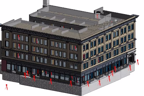
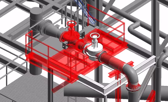
When record drawings do not match the as-built conditions facility managers are at risk of avoidable change orders, delays, budget overruns, and even damage or injuries. Let GPRS’ in-house team create an as-built for your project – showing actual existing conditions above or below ground… or both. Our 3D Laser Scanning services deliver up-to-date and accurate construction as-builts, existing condition drawings, 2D CAD drawings, 3D BIM models, 3D mesh models, digital twins, point clouds, updated floorplans, reflected ceiling plans and more for construction design, prefabrication, clash detection, facility modifications, and asset management.
We deliver up-to-date, accurate data to improve communication and coordination, identify hazards to keep all workers safe, reduce errors and reworks, and deliver your project on time and on budget.
With Project Managers in every major market and city across the United States, GPRS has an unmatched nationwide service network that makes it quick and easy to find an expert Project Manager in your area. GPRS can reach your location within 24 to 48 hours of contact to solve all and any of your project needs.

GPRS Delivers Complete Infrastructure Visualization
GPRS is the only company in the U.S. that can capture your entire site or facility, above and below-ground, to provide you with accurate as-builts, private and public utility maps, 2D CAD drawings, 3D BIM models, virtual tours, WinCan reports, and more documenting architectural, structural, MEP, and subsurface utility existing conditions.
We can manage data, maps, and models for your entire facility. Important operational data can be accessed in real-time via GPRS’ SiteMap® digital storage software and app to improve operations and plan for maintenance.
Utility Locating Services
GPRS utility locating service utilizes ground penetrating radar (GPR) and electromagnetic (EM) locating technology to locate, mark, and map existing underground infrastructure such as power lines, gas lines, pipelines, water lines, sewer lines, potential voids, and additional buried facilities and utility lines. This information is critical for projects where construction or excavation activities are planned to mitigate accidental utility strikes, plus keep your team and facility safe. GPRS delivers complimentary CAD utility site maps in PDF, KMZ, and SHP file formats, and can export your utility data into a wide variety of drawings, maps, and models to advance communication and collaboration on your project. All clients receive instant access to complete and aggregated site records in Sitemap® GPRS’ digital storage software and app, where data is geolocated, layered, and securely shareable.
Concrete Scanning Services
Concrete scanning is a non-destructive method to assess concrete using GPR to locate, identify, and mark utilities and objects such as rebar, post tension cables, beams, conduits, and piping embedded within concrete slabs and structures prior to anchoring, cutting, coring, and drilling. Concrete scanning ensures the safety of workers and prevents accidents by identifying potential hazards before any work occurs. Concrete markings can be 3D laser scanned to create a permanent record of the site, data can be delivered in 2D CAD drawings, 3D BIM models, and virtual site tours.
3D Laser Scanning Services
GPRS 3D laser scanning services document the exact architectural, structural, and MEP system layout and dimensions of existing buildings, facilities, and sites. We high-definition laser scan building infrastructure: structural, mechanical, electrical and plumbing features; furnaces, equipment, conduit and piping down to ½ inch diameter. GPRS Project Managers use industry-leading Leica survey-grade laser scanners to capture 2-4 millimeter accurate existing site conditions in the form of a point cloud. Our in-house Mapping & Modeling Team can transform those point clouds into customized 2D CAD drawings, 3D BIM models, 3D mesh models, TruViews, and 3D virtual tours at any level of detail for visualization, analysis, design, construction, renovation, prefabrication, and facility modifications. We can work directly for municipalities, Engineering firms and privately owned facilities.
Video Pipe Inspection Services
Video Pipe Inspection Services by GPRS deploy robotic crawler CCTV cameras, lateral launch cameras, and push cameras to inspect and document water, sewer lines, and lateral pipelines to locate clogs, investigate cross bores, find structural faults and damage, and conduct lateral sewer line inspections. GPRS Project Managers deliver NASSCO-certified WinCan reports with the exact location, video, and photo of each defect, ranked by severity so you can plan for maintenance and repairs.
Leak Detection Services
GPRS specializes in all types of leak detection services, including municipal, industrial, and residential. Our Project Managers are leak detection specialists who utilize multiple technologies to locate your leak and the expertise to map and provide many other insights into your water distribution and/or fire suppression systems. GPRS does this by utilizing a variety of equipment paired with our industry-leading SIM (Subsurface Investigation Methodology) processes. The equipment and methods used include acoustic leak detectors, leak noise correlators, video pipe inspection (CCTV) cameras & sondes, ground penetrating radar, and electromagnetic locating, among others.


Let's Get To Work
Schedule A Project

CUSTOM SERVICE PLANS

Scheduling

Pricing

Approach

mapping & Modeling
GPRS delivers the most up-to-date, accurate and comprehensive site data possible in the format required for your project. We provide complimentary KMZ and PDF maps with every utility locate we perform. Our Mapping & Modeling Team can create a wide variety of customizable maps and models, from a simple GPS-enabled map of your utility locate, to highly-detailed 2D CAD drawings and 3D BIM models, depending on your needs.
AS BUILT DRAWINGS
2D MAPS & 3D MODELS
SITEMAP® MOBILE APP

One Call Program

Public Property
Private Property

Embedment
What are the Benefits of GPRS As-Built Services?
- Complete documentation of as-built conditions
- Precise, high speed data collection
- Dimensionally accurate, measurable, and shareable data sets
- Fast turnaround of project data
- Decreased disruption of project environment
- Reduced need for site revisits
- Safe solution for inaccessible locations
- Reduction in change orders, delays, and cost overruns
What Types of Facilities Has GPRS Provided Services For?
- Industrial Facilities
- Manufacturing Facilities
- Assembly Facilities
- Distribution Facilities
- Food and Beverage Production
- Pharmaceutical Production
- Chemical Plants
- Specialty Ingredient
- Water Treatment and Wastewater Treatment Plant Facilities
- Energy Facilities
- Oil and Gas Facilities
- Asphalt Plants
- Quarries, Stone and Other
- Substations
- Mechanical Rooms
- Steel Mills
- Paper Mills
- Manufacturing Plants
- Coking Plants
- Power Plants
- Process Plants
- Steam Plants
- Hospitals and Universities
- Agricultural Cooperatives, Grain Facilities & Ethanol Plants
What Customizable Maps & Models Can GPRS Deliver?
- Point Cloud Data
- 2D CAD Drawings
- 3D BIM Models | Building Information Models
- 3D Mesh Models
- 3D Photogrammetry
- TruView
- Virtual Tours via WalkThru 3D
- 2D Floor Plans via FLRPLN
- 3D CAD Floor Plans via FLRPLN
- Template Modeling
- Reconciliation of Clients 2D Drawings
- Reconciliation of Clients 3D Design Model
- Comparative Analysis
- Deformation Analysis
- Floor Flatness Analysis | Floor Contour Mapping
- Volume Calculations
- Structural Steel Shape Probability Analysis
- Wall Plumb Analysis
- New Construction Accuracy Analysis
- New Construction Comparative Analysis
- 2D CAD of GPR Markings
- Reflected Ceiling Plans
- Emergency Floor Plans
- 2D CAD Plan Views, Elevations, Sections, Details, Isometric Drawings
GPRS Pricing
The cost of GPRS services can vary widely depending on your project scope. GPRS customizes every quote specific to your project’s needs. GPRS Project Managers use the latest technology to capture every detail of your site, delivering building dimensions, locations, and layout with millimeter accuracy. This can include the aboveground structural, architectural, and MEP features, plus underground utility and concrete markings. Our Mapping & Modeling Team can deliver point clouds, 2D CAD drawings, 3D BIM models, 3D Mesh models, TruViews, and Virtual Tours at any level of detail.
What can we help you visualize?


.webp)