.svg)
Environmental Due Diligence


Protect Your Project from Hidden Risks with GPRS Utility Locating, Mapping, and Modeling
If you're managing environmental concerns during due diligence or suspect contamination, it's critical to understand the impact to soil, groundwater, or soil vapor while keeping your team safe and costs down. Your priority is to reduce risks during soil borings, vapor pin installation, and UST investigations.
GPRS utility locating identifies underground utilities and UST components, helping you clear soil borings, install vapor pins, drill safely, and avoid damage. Our custom utility CAD maps protect infrastructure, while conceptual site models (CSMs) reveal potential contaminant migration pathways and guide your next steps.
We provide a full suite of services, including utility locating, concrete scanning, video pipe inspection, and 3D laser scanning, tailored to your project needs to support safe sampling, hazard identification, and remediation planning.
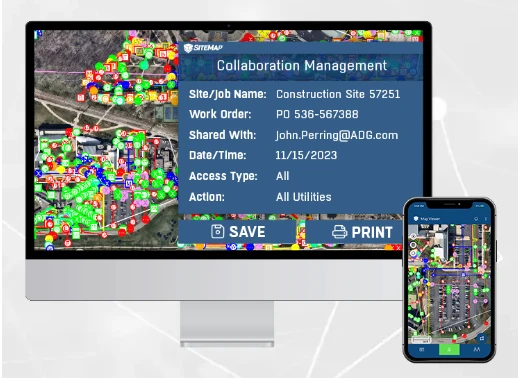
Deliverables are uploaded to GPRS’ SiteMap® GIS platform, giving you fast access to accurate data and insights to help you reduce risk, stay compliant, and make confident decisions.
Soil and Groundwater Sampling
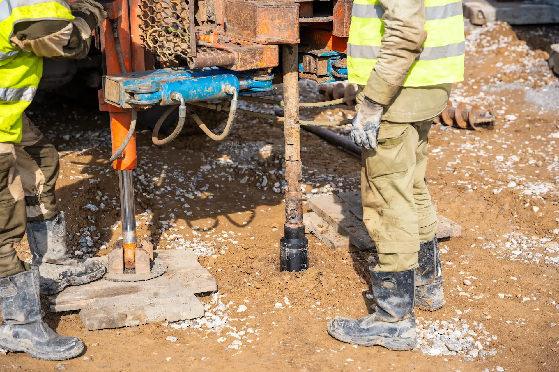
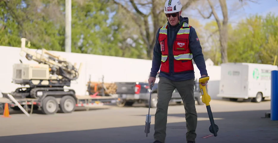
Identifying safe boring locations is difficult when underground utilities are unknown or poorly mapped. Drilling without clearance can cause strikes, injuries, delays, and added costs. GPRS provides accurate maps of public and private utilities using utility locating and video pipe inspection. We clear drilling locations in advance to protect your team and infrastructure. Reliable utility data reduces risk, supports efficient sampling, and helps your team maintain safety while in the field.
Soil Vapor Assessment
Contaminants like petroleum and solvents can migrate as vapor, posing health risks. Installing vapor pins requires drilling through slabs, risking conduit strikes and damaging reinforcements, especially in buildings with little to no documentation. GPRS SIM-certified Project Managers use concrete scanning and utility locating to identify shallow utilities and reinforcement before drilling. We support vapor intrusion investigations with subsurface data, mapping, and modeling. You get accurate data that reduces disruption, prevents strikes, and supports compliance with health and safety regulations.
UST & LUST Locating and Mapping
Locating underground storage tanks is challenging when records are missing. Uncertainty around tank location or condition can lead to costly mistakes and regulatory issues. GPRS uses utility locating to safely locate orphaned, abandoned, or active UST systems. We provide CAD maps and conceptual site models to support remediation and compliance. Fast, accurate data helps you reduce risk, protect property value, and make informed decisions during due diligence.
Delineation and Remediation
Tracking contamination across soil, groundwater, or soil vapor can be complex. GPRS provides scalable solutions from utility locating, concrete scanning, video pipe inspection, as well as mapping and modeling, to meet the needs of your project. Precise data and efficient workflows help you save time, reduce costs, and make confident decisions that support reaching No Further Action (NFA) or regulatory closure.


Let's Get To Work
Schedule A Project


CUSTOM SERVICE PLANS

Scheduling

Pricing

Approach

mapping & Modeling
GPRS delivers the most up-to-date, accurate and comprehensive site data possible in the format required for your project. We provide complimentary KMZ and PDF maps with every utility locate we perform. Our Mapping & Modeling Team can create a wide variety of customizable maps and models, from a simple GPS-enabled map of your utility locate, to highly-detailed 2D CAD drawings and 3D BIM models, depending on your needs.
AS BUILT DRAWINGS
2D MAPS & 3D MODELS
SITEMAP® MOBILE APP

One Call Program

Public Property
Private Property

Embedment
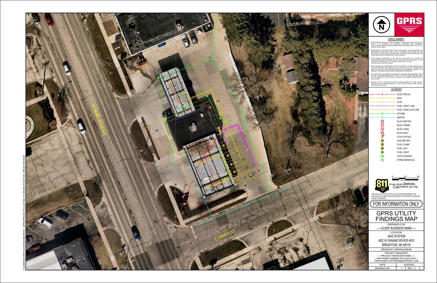
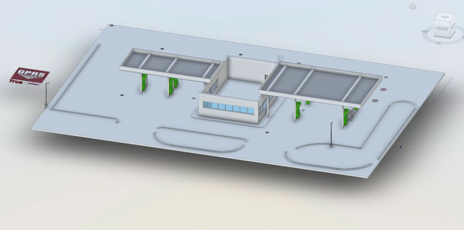
GPRS Utility Locate and 3D Laser Scan for a Gas Station
Location: Brighton, Michigan
Task:
A Michigan gas station requested utility locate and as built data to document the existing conditions for site upgrades and to develop an emergency response plan for potential leaks. Accurate 2D utility locate maps, a 3D BIM model, and a conceptual site model (CSM) were created of the gas station, underground storage tank system, and surrounding utilities.
Problem:
- The gas station lacked as built site information required for compliance with environmental regulations, essential to plan for site upgrades, and necessary to take prompt corrective action in the case of an emergency.
- The client did not have an accurate conceptual site model (CSM) to understand and interpret contaminant fate and transport in the subsurface.
Solution:
- GPRS Project Managers used state-of-the art equipment to perform ground penetrating radar (GPR), electromagnetic (EM) locating, video pipe inspection (VPI), leak detection, 3D laser scanning, and drone photogrammetry services at the gas station.
- The GPRS Mapping & Modeling Team delivered accurate as built and utility location data in point cloud, 2D maps, 3D BIM model, and CSM formats, to help eliminate guesswork from decision making, and prevent time-consuming and dangerous mistakes and the costs associated with them.
- The gas station received access to millimeter-accurate information to efficiently plan work and drill safely.
- Locating underground storage tanks, including their depths, can help the station owner detect unusual fluctuations in fuel levels and assess any potential leak faster.
- Detailed site maps can help to communicate the location of a leak, the most likely paths and extent of horizontal and vertical delineation, and to plan assessment and mitigation efforts.
Benefits:
- Infrastructure location and mapping are vital before conducting any construction or subsurface work like soil boring, or coring concrete to drop vapor pins – to eliminate clashes and utility strikes and keep workers and the community safe.
- Comprehensive site data is essential for the early detection and management of petroleum leaks at a gas station, to help minimize environmental damage and ensure the safety of employees and the surrounding community.
- GPRS as built maps and models provide accurate information to avoid hitting a UST or system component, and to avoid a utility strike when sampling soil.
- The GPRS SiteMap® mobile app securely stores utility data, geolocated and layered, and securely accessible for the station stakeholders to share with those who may need it.
- The data GPRS collects can also be used to develop the utility portion of a conceptual site model (CSM) to visualize migration routes, communicate with stakeholders, make informed remediation decisions, and protect the team on site and the environment.
With over 500 Project Managers, in every major market and city across the United States, GPRS has an unmatched nationwide service network that makes it quick and easy to find an expert Project Manager in your area. Having access to accurate facility information is crucial for project upgrades and emergency response. GPRS can quickly deliver utility locate and as built data of your next project to Intelligently Visualize Your Built World®. Contact us today.


Case Studies


Related Articles