

.svg)
Engineers and contractors have more project data than ever before thanks to 3D laser scanning technologies such as LiDAR (light detection and ranging) and photogrammetry. These methods of reality capture collect millions of data points and store them in the form of a point cloud. The point cloud generated from laser scanning and photogrammetry is important for construction planning because it provides a highly accurate and detailed representation of a building or site.
What is a Point Cloud?
According to US CAD, “laser scanners digitally capture objects using laser light. The result is a point cloud consisting of millions of points that produce a highly accurate 3D representation of the as-built conditions. A point cloud can be easily imported into leading CAD and BIM software solutions to further use in the design and construction process.”
GPRS defines a point cloud as a collection of data points in a 3D coordinate system. Each point in the point cloud is defined by its XYZ coordinate, and may also include additional attributes such as color, intensity, and reflectance. The reflectance characteristics of each LiDAR point cloud document the reflectance properties of points to known values (high, medium, low) which are characteristic of commonly classified features, such as vegetation, asphalt roads, buildings, and water bodies.
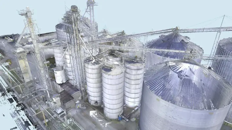
To 3D laser scan a site, a GPRS Project Manager positions a laser scanner at various locations, taking individual scans from varying viewpoints to capture comprehensive site data. A single scan from a 3D laser scanner can generate millions of individual points or XYZ coordinates, each representing a specific location in the 3D space. The captured points record every surface color, detail, and texture, creating a direct representation of the scanned project site with 2-4 millimeter accuracy.
The size of a point cloud can vary significantly depending on several factors, including the resolution of the scan, the area covered, and the level of detail captured. For example, a laser scan of a large building could produce a point cloud with billions of points. Higher density scans capture more points per area and provide a more detailed and accurate representation of a space, resulting in an even larger point cloud file size.
Projects can include hundreds of laser scans, stored in large files that can create datasets in excess of a terabyte. Registering, storing, and manipulating these large datasets can be challenging.
Why is Point Cloud Registration Important?
Registering a 3D laser scan point cloud involves aligning multiple scans of the same area taken from different positions into a single, coherent point cloud. The registration process can be complex and time-consuming, especially for large and detailed point clouds. Getting the registration right ensures the most accurate measurements, drawings, and models.
GPRS Project Managers are trained to acquire data in ways that allow for good, tight registration. They capture multiple scans of the site from different positions, ensuring that there is sufficient overlap between scans.
The Mapping & Modeling Team combines the aligned scans into a single, merged point cloud. The team converts raw scan data to Autodesk ReCap scan files (RCS files) and project files (RCP files). They perform quality checks on every point cloud, removing noise, setting the coordinate system, checking for any misalignments or inconsistencies, and validating the precision of the registration. The team makes sure all the scans fit together exactly as they should, so that a client’s point cloud and models will have tight lines and accurate measurements.
GPRS has a team of experts who can register datasets of any size. We have completed projects with thousands of individual scans, on sites that are hundreds of acres large, and with miles of piping. No matter how big or small a project, GPRS provides client’s with the most precise point clouds to create accurate 2D drawings and 3D models.
How Does GPRS Manage Large Point Cloud Data Sets?
Once the point cloud is registered, it can be exported to a client for analysis, visualization, or processing. By consulting with the GPRS Mapping & Modeling Team, we can implement different strategies to effectively manage large point cloud datasets for our client’s architecture, engineering, and construction projects.
- Data Storage: We recommend that our clients use a storage solution that can handle large datasets efficiently. This might include cloud storage services, network-attached storage (NAS), or dedicated storage servers.
- Data Compression: We can use data compression techniques to reduce the size of the point cloud files without significantly affecting their quality. GPRS is also able to reduce the file size of the point cloud by creating unified RCS files or dividing a project into multiple RCS files to use individually.
- Data Streaming: Instead of loading the entire point cloud into memory at once, we recommend streaming techniques to load and process the data in chunks. This can help reduce memory usage and improve performance.
- Level of Detail (LOD): Our Mapping & Modeling Team can generate multiple levels of detail for the point cloud data, with higher levels of detail for areas of interest and lower levels of detail for less important areas. This can help reduce the overall size of the dataset while still maintaining important details.
- Data Filtering: We can use filtering techniques to remove unnecessary or redundant points from the dataset. In ReCap, we can drastically reduce the point cloud file size by changing the spacing between the unified points. We can use point decimation techniques to reduce the point cloud resolution by omitting a certain number of pixels in rows, columns, or both columns and rows. We can also remove points that are outside the area of interest or that represent noise in the data. For example, we can crop the data down to not show superfluous data, like removing data from across the street.

What Are the Applications of Point Cloud Data?
Point cloud data has become the new standard in pre-design planning for the architecture, engineering, and construction industries. Having a virtual dataset of the project site gives our clients’ the ability to utilize real-time data for decision making.
Point clouds are used to create 2D CAD drawings and 3D BIM models to expedite the planning, design, construction, and management of construction and infrastructure projects.
GPRS is a leading provider of 3D laser scanning and 3D photogrammetry services, helping clients to successfully complete their most complex projects with accurate as-built documentation, point clouds, 2D CAD drawings, and 3D BIM models.
What can we help you visualize?
Frequently Asked Questions
What is photogrammetry?
Photogrammetry is the process of capturing images and stitching them together to create a digital model of a structure or site for visualization and analysis. It is a fast way for architecture, engineering, and construction teams to document accurate as-built site conditions.
What is 3D laser scanning?
3D laser scanning uses LiDAR technology to capture as-built documentation of existing buildings or sites. Once data is acquired, a point cloud is generated and used to develop 2D CAD drawings or 3D BIM models, expediting the design, planning, and development of projects.
What scanners are used for data collection?
GPRS utilizes a terrestrial 3D laser scanner for data collection, as they are able to document vertical structures, such as buildings and facilities. These scanners sit on a tripod and can take 1-3 minutes to complete each scan, depending on the project requirements. Terrestrial laser scanners are known to produce the most accurate point clouds due to the fact that they are stationary. A laser scanner can only capture what is in its line of sight. Scanners are positioned around a site and take individual scans from varying viewpoints to capture complete site data. The captured points record everything from surface detail and texture, to color, creating a direct representation of the scanned project site.