

.svg)
What is Photogrammetry?
Photogrammetry uses LiDAR technology to digitally document buildings, facilities, and sites with high-resolution photographs. Photogrammetry allows users to extract geometric information from the two-dimensional images taken.
Photos must be taken from various positions and angles to capture three-dimensional site coordinates. Proper techniques provide users with the ability to accurately measure depths and distances from one point to another. Overlapping photographs can be stitched together to create an accurate digital twin of a project site.
What is a Digital Twin?
Digital twins in construction are accurate virtual models of physical assets, structures, and systems. They provide construction professionals precise data to aid in project planning, execution, and ongoing maintenance. Digital twins eliminate the need for site visits, expedite decision making, and increase efficiency.
GPRS uses the Matterport Pro3 for photogrammetry to capture precise spatial data for planning, analysis, calculations for and construction use. Comprehensive above ground architectural, structural and MEP systems, plus utility and concrete markings can be captured with millimeter accuracy.
What are the features of the Matterport Pro3?
The Matterport Pro3 can render large-scale projects at a high level of precision. Updated with LiDAR-based scanning, the Matterport Pro3 offers 20mm accuracy within a 10m range and has a maximum 100m scanning range. Data is collected at 100k points per second, in under 20 seconds per sweep. It features a custom 30-megapixel sensor and 12-element camera lens with an ultra-wide angle to produce full-color digital twins.
The Matterport Pro3 allows you to create walk throughs, floorplans, point clouds, 3D models of physical spaces, and more with the 4K HDR photographs it captures.
Overview of Matterport Pro3 Features:
- Scans indoor & outdoor static environments
- Produces a full-color digital twin at a 10m range with 20mm accuracy
- 0.5m – 100m scan range
- 10 points per degree output on both axes (horizontal & vertical)
- Completes each sweep in <20 seconds

What Products Can GPRS provide with the Matterport Pro3 Data?
GPRS offers the following products from the Matterport Pro3 data:
WALKTHRU 3D
Get existing conditions and area measurements in real time with 3D photogrammetry via WalkThru 3D. GPRS can provide immersive 3D virtual tours that allows you to walk your team, designers, and stakeholders remotely through your site or facility to eliminate travel and streamline communications and collaboration for geographically scattered organizations. This can help in visualizing the site, identifying potential issues, and making informed decisions without the need for physical presence.

FLRPLN
Take the rectified, real-time 3D photogrammetry from WalkThru 3D and create an accurate plan view of your project to aid planning, design, and risk mitigation. A floor plan can also help identify potential hazards, develop emergency action procedures, safety protocols, and train personnel on site-specific procedures.

PROCAP
Capture your construction progress from start through completion with ProCap Progressive Capture. Your Project Manager can capture locations of rebar, PT cables, and concrete embedments pre-pour, MEP and HVAC feature installation progress, provide accurate timelines for stakeholders, and key milestone completions. Accurate data minimizes clashes and change orders, and streamlines communications. By capturing scans regularly, customers can track the evolution of the site, monitor construction milestones, and ensure that work is proceeding according to schedule.

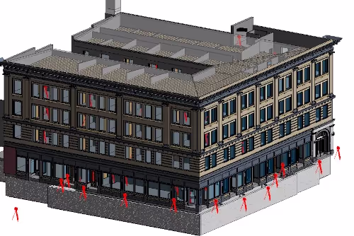
TRUBUILT
Eliminate outdated and inaccurate as-builts for your existing construction conditions in real time with 2D CAD plan views of your site or facility infrastructure, above and below ground, to break down information silos to collaborate with the comprehensive, layered, data. As-builts can serve as comprehensive documentation for reference, maintenance, and renovation projects.

POINT CLOUD
An E57 file contains a high-density point cloud, pano images, and metadata from each scan location in the Matterport space. The E57 file can be used in a range of applications by architects, MEP engineers, general contractors, mechanical engineers, electrical engineers, BIM managers, VDC managers, and other construction professionals who need a higher density point cloud.

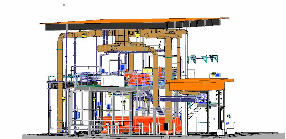
3D BIM MODEL
The GPRS Mapping & Modeling Team can generate a standard detail 3D BIM model from the point cloud data. A 3D BIM model encompasses not only geometry and spatial relationships, but it also documents building features, such as specific information about the type of materials used, the quantity used, and how those characteristics impact the building as a whole. BIM can be thought of as a database of information, helpful in determining project materials and cost – to documenting the site after construction – to facilitating operations of the facility. This information can be used to actively manage a project every step of the way.
Why Choose GPRS? The GPRS Difference?
GPRS offers a wide range of LiDAR, photogrammetry, 3D laser scanning, and visualization services. Each GPRS Project Manager and Coordinator works closely with each client to define the project scope and use the right tools to accurately map and model each project. GPRS services a wide variety of industries, including:
- Architecture
- Engineering
- Design
- Construction
- Oil & Gas
- Facility Management
- Historical Preservation
- Stadium & Theater
- Education
- Healthcare
- Water & Wastewater
- Energy & Utility
- Multimedia & Entertainment
GPRS Project Managers are required to complete industry-leading Subsurface Investigation Methodology 101 certification before performing field services on your job site. Every Project Manager completes 80 hours of classroom training and 320 hours of field mentoring to achieve 101 certification.
GPRS ensures you have all the information you need to get the job done right, delivering accurate as-built data to expedite project planning and reduce change orders, delays, and costs.
What can we help you visualize?
Frequently Asked Questions
What is LiDAR?
LiDAR stands for Light Detection and Ranging. It is a remote sensing technology that uses lasers to measure the distance between the sensor and the target. A LiDAR sensor emits a laser beam and measures the time it takes for the beam to bounce back off an object. By repeating this process many times, a LiDAR system can create a 3D point cloud that represents the shape and location of objects in the environment.
How is photogrammetry utilized in construction?
Photogrammetry is a new construction technology that can be used to capture a space in 3D. This comprehensive platform transforms building spaces into digital twin models. Users can view a building layout without being there.
What is a point cloud?
A point cloud is a 3D description of spatial data consisting of geometric points in space, as measured by capture devices. These points typically represent the 3D shape of a physical object. Each point position has its set of Cartesian coordinates (X, Y, Z). Point clouds are most commonly used to capture the existing (as-built) conditions of a structure. Point cloud data is commonly used to extract analysis from these structures, and to import into 3D design and BIM software workflows.