

.svg)
To be classified as “historic,” buildings typically are 50 years old or older and tied to important events.
One of the earliest preservation projects in the United States took place in 1816, to salvage Independence Hall in Philadelphia, Pennsylvania, from demolition. As of mid-2026, there are now more than 100,000 properties listed in the National Register of Historic Places in the United States.
With there being such a vast number of historic sites, buildings, and structures, it is very important to keep their history alive through preservation efforts.
Historic preservation, also known as built heritage conservation, is not just about saving old walls. It is the work of protecting the form, materials, character, and story of a historic property while keeping it useful in the present.
Think of preservation as protecting the places that hold meaning in the built environment. For example, it might be a landmark that played a key role in your community's history, or the celebration of people, events, locations, and concepts that you are proud of.
The National Building Museum describes historic preservation as “physical saving of buildings and valuing the craft and materials that have gone into their creation, but it is also the saving of stories about the people who designed the buildings, who built them, and who used them.”
At the same time, gb&d magazine notes that historic preservation prioritizes “preserving, protecting, and conserving those buildings and structures with sufficient historical significance.”
For architects, historic preservation requires a different mindset than standard renovation.
Preservation adds another layer – the work must protect the building’s historic character while still solving modern performance needs. Every design choice must be made with a different mindset from the norm because of preservation standards.
And that is still only the tip of the iceberg, as the complexity of preservation extends far beyond design intent. Older buildings often have undocumented utilities, hidden infrastructure, outdated as-builts, and unique existing conditions shaped by irregular geometry, deterioration, and historical significance.
What Are the Methods of Preserving Historic Structures?
The Secretary of the Interior’s Standards for the Treatment of Historic Properties, a codified framework by the National Park Service, outlines four recognized treatment paths:
- Preservation: Retains a historic building in its current form by keeping its existing materials, features, and integrity instead of replacing them or introducing new construction
- Rehabilitation: Repairs, alters, and adds to a historic property in limited ways so it can meet modern needs while still preserving its character
- Restoration: Returns a property to a specific period in its history by removing evidence of other periods and recovering missing features from the selected time
- Reconstruction: Recreates vanished or non-surviving parts of a historic property to replicate its appearance at a specific period and relies on documentary and physical evidence
Each of these standards assists building owners, preservation consultants, contractors, architects, and stakeholders when working on historic building projects.
Why Does Historic Preservation Matter at the City Level?
Historic preservation matters at the city level because communities often see these buildings as part of their identity.
According to the City of Harrisburg, Pennsylvania, “Culture, community, and historic preservation are tied together.” They also note that disregard for culturally meaningful structures may have nuanced consequences: “Demolition of significant buildings or entire neighborhoods for new construction negatively impacts local culture and community identity and may involve the displacement of residents.”
Once a significant building loses its original fabric and undergoes demolition, that loss cannot be undone. If the structure is rebuilt, it will be with modern materials and techniques, thus losing the significance and charm of the original infrastructure.
Overall, the reality of preservation raises the stakes for architects, engineers, and owners because preservation work is also about keeping the building’s culture and memory.
Why Do So Many Historic Preservation Projects Begin with Incomplete Information?
Many historic preservation projects begin with incomplete information because the building changed long after the original drawings were made.
Historic properties may go through decades of repairs, additions, tenant fit-outs, system upgrades, and emergency fixes. Some changes appear in a permit set, but many will not. Over time, the archive record will drift away from the building as it exists today because of the undocumented changes throughout the years.
This is why having accurate building documentation matters. Preservation teams need reliable existing conditions documentation before they issue demolition notes, route new systems, or evaluate structural limits. Yet, historic property renovations often start with scans of old plans, partial hand sketches, or field notes from several sources. Some rooms had never been documented at all.
Mechanical, electrical, and plumbing systems could also cross the building in ways that aren’t depicted on any document. Underground utilities could run through courtyards, alleys, or basements. Without up-to-date plans noting their paths, the result is an uneven, incomplete picture of the older property.
SAA Architects points out that time, weather, neglect, and changing use all influence archival structures. Teams engaging in these kinds of projects have a particularly acute need for current field data that reflects the building’s underlying elements as they stand now, not merely as the building appears.
This is why heritage laser scanning, as-built drawings, and historic building documentation play such a critical role in preservation planning.
%20(1).webp)
Accurate as-builts provide you with a reliable baseline to preserve, restore, rehabilitate, or reconstruct a historic property – whether it be a home, church, or business.
What Happens When Existing Conditions Are Unknown in Historic Preservation?
When existing conditions are unclear, planning and executing preservation projects become harder. The building could appear stable on the surface, while serious issues remain hidden inside walls, beneath finishes, or behind previous repair work.
Structural damage, hidden deterioration, and unrecorded changes often remain unseen until construction starts. At that point, your team might need to stop work, revise the design, or change the scope of work.
Historic properties also carry risks that standard renovation projects don’t face in the same way. Some hazardous materials also remain in place, such as asbestos, lead paint, or deteriorated piping.
Long-term environmental exposure can also affect the building in ways that are not initially obvious. Water intrusion, freeze-thaw cycles, soil movement, and invasive vegetation can weaken materials over time and create deeper structural or envelope issues that slow or stop work.
The problem grows more complex when previous changes were never documented. Throughout the life of a historic building, walls may shift, systems might reroute, and repairs can cover important evidence of its original construction.
These undocumented alterations can interrupt design coordination, create safety concerns for workers, and increase the risk of damaging what locals hold so dear.
Nealia Morrison, Associate Principal at DBVW Architects, leveraged a historic preservation 3D scan to create a restoration plan for the Newport Restoration Foundation’s Rough Point Museum in Newport, Rhode Island.
“In the past, I think we've all done hand measuring, but we needed the level of detail that was provided in the point cloud. The laser scan really created the foundation of all our documentation that we were able to supplement and do specific, really targeted assessments,” stated Morrison.
%20(1).webp)
How Can Preservation Teams Reduce Risk Before Design Begins?
Preservation teams can reduce risk by leveraging a professional laser scanning professional to deliver an up-to-date record of the structure.
This means you don’t have to depend on repeat visits, scaffolding, or manual measurement methods like tape measures or a single-point (“disto”) laser. You can get detailed data quickly and accurately using advanced heritage laser scanning technology and BIM modeling.
In preservation, non-invasive methods matter as much as accuracy. For historical buildings and sites, GPRS uses utility locating, concrete scanning, and laser scan technology to capture precise conditions without causing damage to the structure.
These technologies reduce the need for blind cuts, exploratory demolition, and unnecessary contact with fragile materials.
David Torrey, Principal of Torrey Architecture, shared the benefits of leveraging cutting-edge reality capture technology for architectural projects.
"Through the power of this new technology, we were able to create scale drawings of an 1836 building. It was quite a feat that involved comparing historic archival photographs with scaled exterior elevations done by [GPRS],” said Torrey.
Torrey goes on.
“Without this innovative approach, creating detailed drawings of the building would have required extensive scaffolding and manual measurements, making it nearly impossible to achieve the level of accuracy we obtained. The point clouds provided by [GPRS] were instrumental in this process, allowing us to scale off them and create 2D elevations on all sides of the structure.”
.webp)
How GPRS Supports Historic Preservation Projects
GPRS supports historic preservation projects by helping you Visualize the Built World®, above and below-ground, before work begins.
Our Project Managers gather field-verified data from older buildings and sites, documenting architectural, structural, MEP, subsurface utility, and concrete reinforcement conditions.
To fully visualize buried infrastructure, GPRS’ Subsurface Investigation Methodology (SIM)-certified Project Managers use ground penetrating radar (GPR), electromagnetic (EM) locating, along with other complementary technologies, to detect public and private utilities, estimate depths where possible, and produce field markings and digital utility maps.
When a project involves post tension or slab-on-grade conditions, our Project Managers use concrete scanning GPR, often alongside EM locating, to find rebar, conduit, post tension cables, and more, then mark those findings on the slab.
GPRS’ Mapping & Modeling Team can directly translate the markings into highly accurate CAD and BIM deliverables.
That accuracy is maintained by GPRS’ verified < 0.20% at-fault incident rate in concrete scanning and utility locating on more than one million jobs nationwide.
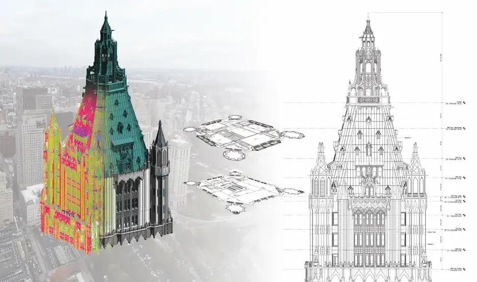
Once underground and embedded conditions are documented, GPRS captures utility and concrete markings with 3D laser scanning. For historic building documentation, GPRS uses terrestrial LiDAR-based scanners to capture millions of precise data points, creating point clouds that serve as the foundation for accurate 2D and 3D as-builts.
From the point cloud data, GPRS’ Mapping & Modeling Team creates customized deliverables tailored to your project, including:
All project data and deliverables can be accessed through SiteMap®, GPRS’ cloud-based GIS platform, giving you and your project stakeholders a single source of truth throughout planning, design, and preservation work.
Architects and design teams can leverage this accurate data to reduce site visits, make more informed design decisions, improve stakeholder coordination, and create precise building documentation that supports both preservation and future planning.
“Our firm has worked with [GPRS] on multiple projects. We greatly appreciate your collaboration and professionalism,” Erik Christensen, Project Manager at Foster Architecture, said. “We specialize in historic preservation, and the Existing Conditions [Documentation] and Revit models are invaluable resources in our evaluation and restoration of historic structures.”
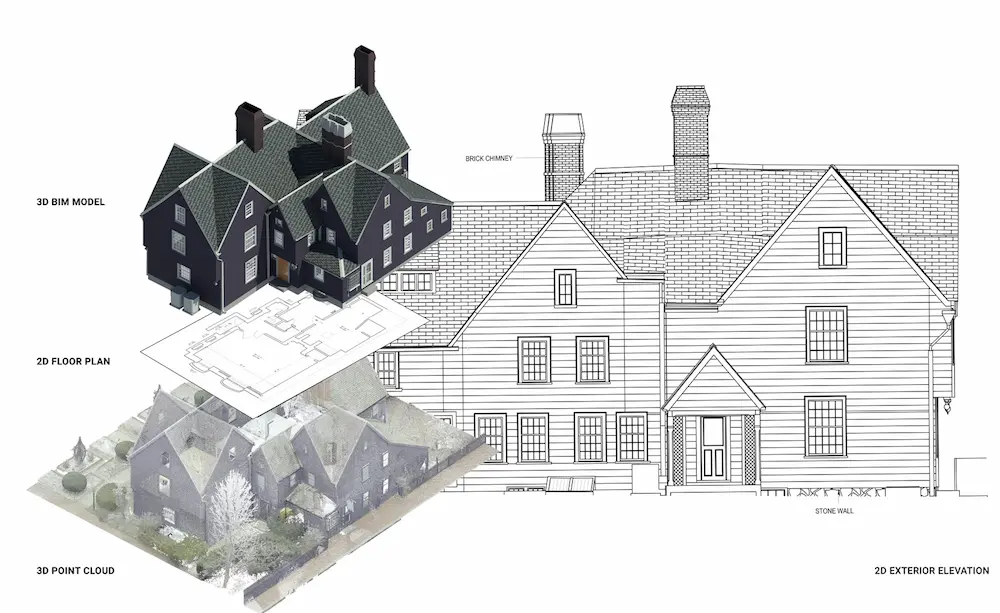
Case Study: House of the Seven Gables
One example shows how GPRS 3D laser scanned and modeled The House of the Seven Gables Campus in Salem, Massachusetts, so the architect could attain preservation standards.
- A National Historic Landmark District in Salem, Massachusetts, needed accurate digital documentation to support preservation planning across several historic structures
- The architect needed reliable existing conditions data to evaluate deterioration, address restoration challenges, and meet the strict preservation requirements
- 3D laser scanning created a precise digital record of the site that supported design development without invasive investigation
GPRS can help you capture the intricate elements of historic buildings that are crucial for preservation design. Let us help you begin projects, completely prepared, so you can start accurate and stay accurate from the very beginning.
What can we help you visualize?
Frequently Asked Questions
What is the Difference Between Historic Preservation and a Standard Renovation?
Historic preservation differs from standard renovation because the work must protect a building’s historic character, materials, and significance while still supporting modern use.
Historic properties often include irregular geometry, hidden infrastructure, outdated as-builts, and undocumented changes that can affect design, approvals, and construction in ways a typical renovation might not. GPRS helps architects, engineers, and contractors reduce that uncertainty with 3D laser scanning, utility locating, concrete scanning, and existing conditions documentation that capture above and below-ground conditions before design planning.
See how GPRS’ work at the House of the Seven Gables shows how accurate scan data, 2D elevations, and a 3D BIM model can support restoration planning at this National Historic Landmark. Read the GPRS case study: 3D Laser Scanning The House of the Seven Gables Historical Site.
What is Heritage Building Information Modeling (HBIM)?
HBIM, or Heritage Building Information Modeling, is a digital process that combines reality capture with BIM workflows to document, analyze, and manage historic buildings. Unlike standard BIM, HBIM starts with the existing conditions of older structures, such as bowed walls, sloped floors, and layered modifications, and turns point cloud data into useful records for restoration and heritage preservation. GPRS supports HBIM workflows with terrestrial LiDAR 3D laser scanning, scan to BIM, scan to CAD, point clouds, and 3D BIM deliverables, providing a reliable digital baseline for historic preservation.
In this HBIM explainer, see how reality capture and BIM modeling work together to create a single, reliable digital record for owners, designers, and conservators.
How Does GPRS’ Concrete Scanning Protect Historic Buildings?
GPRS’ concrete scanning services protect historic buildings by helping project teams identify hidden anomalies and hazards before they cut, core, anchor, or selective demolition begins.
Ground penetrating radar (GPR) and electromagnetic (EM) locators are used to locate rebar, conduit, post tension cables, and other concealed features inside concrete, which help reduce the risk of accidental damage to historic fabric and structural elements.
GPRS’ SIM-certified Project Managers use non-destructive handheld ground penetrating radar (GPR) concrete scanning antennas, often alongside complementary technologies such as EM locating, to give your team a 99.8% accurate picture of the infrastructure within and beneath your slab.
See how GPRS investigated a suspected time capsule inside a nearly 200-year-old church wall without damaging the masonry. Read the GPRS case study: How GPRS Helped a Pennsylvania Church Locate a Long-Lost Time Capsule Without Damage.
Why Do Accurate As-Builts Matter in Historic Preservation?
Accurate as-builts matter in historic preservation because they replace guesswork with an accurate point of departure for designs. Historic buildings often lack reliable records of structural changes, MEP routing, subsurface utilities, and prior repairs, which increases the risk of redesign, delays, and irreversible damage once work begins. GPRS’ Mapping & Modeling Team creates accurate 2D and 3D as-builts through 3D laser scanning, utility locating, and concrete scanning, all delivered in SiteMap, so your team can meet compliance and design with confidence.
See how GPRS’ point clouds, TruViews, utility maps, 2D CAD drawings, and an architectural and structural BIM model helped an architect plan historic church renovations with confidence while maintaining historic integrity. Read the GPRS case study: Precise As-Built Conditions of Church and School.