

.svg)
What Is Augmented Reality in the AEC Industry?
Every construction project, renovation, and infrastructure upgrade is shaped by what lies beneath it. Buried utilities, post tension cables, conduit systems, and subsurface structural elements are invisible to the naked eye, yet they cause catastrophic delays, safety incidents, and cost overruns when left unmapped. Augmented reality (AR) is changing that. By overlaying geospatially accurate digital information directly onto the physical environment, AR gives project teams visual access to hidden infrastructure exactly where it exists in space.
In the Architecture, Engineering, and Construction (AEC) industry, augmented reality means using mobile devices, tablets, and spatial computing platforms to layer digital data over a live view of the physical world. That data can include building information models (BIM), utility maps, GIS layers, and 3D point clouds.
Unlike virtual reality, which replaces the user’s environment entirely, AR supplements it. Field crews see their actual jobsite and the underground infrastructure beneath it at the same time, through the same device they already carry.
The adoption of AR across AEC professions has accelerated alongside advances in building information modeling (BIM), geographic information systems (GIS), mobile computing, cloud collaboration platforms, and reality capture technologies. Companies including Autodesk, Trimble, Esri, and GPRS have each contributed to the development of AR-enabled construction workflows.
Among these, GPRS has distinguished itself as a pioneer in subsurface visualization and infrastructure mapping through its SiteMap® platform, utility locating services, and SiteMap® Information Modeling (SIM) framework.
Why Augmented Reality Matters on the Jobsite
Traditional construction workflows rely on paper drawings, emailed PDFs, and desktop software that create a real disconnect between project information and the physical environment. A field supervisor at the edge of a planned excavation zone may have the utility map open on a laptop in the trailer and the as-built drawings in a binder, but neither one tells him what is directly beneath his feet at that moment. That gap is where mistakes happen.
According to 811 Before You Dig, utility strikes cost contractors $30 billion dollars annually in the United States. The consequences aren’t limited to dollar figures. Felt impact on projects runs from service disruptions and project delays to injuries, fatalities, and environmental damage. Inaccurate or inaccessible subsurface information is a leading cause of those damages. AR addresses this directly by placing utility data inside the field environment rather than in a separate document that crews must mentally translate into physical space.
The financial case for AR integration is just as strong. Research from FMI Corporation estimates that rework accounts for roughly 30% of all work conducted on U.S. construction projects. A significant share of that rework traces back to coordination failures: work installed in conflict with existing or planned systems that has to be removed, relocated, or modified after the fact. AR-based clash detection and BIM overlay workflows give project teams the spatial awareness to catch those conflicts before they get built into the structure.
Those cost and schedule impacts are often worse than people expect, and worse than they report. In How Big Things Get Done, researcher Bent Flyvbjerg notes that while most project leaders know cost and time overruns are common, they routinely underestimate just how common they are. Most assume a 10 to 15% budget buffer is adequate protection.
The data tells a different story. According to Bent Flyvbjerg in “How Big Things Get Done,” overruns across major infrastructure projects consistently exceed those thresholds by a wide margin, meaning the “safe” buffer most teams build in is often not. When rework from coordination failures compounds those overruns, the financial damage adds up fast. AR tools that flag conflicts before work is installed are not just a convenience; they are a meaningful line of defense against cost spiral.
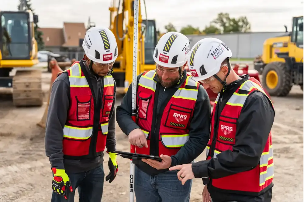
GPRS positions its SiteMap augmented reality features directly within this context. By allowing field crews to walk a jobsite and see subsurface utilities in their physical space, the SiteMap mobile app converts the abstract data produced by utility locating and 3D laser scanning services into actionable spatial intelligence at the point of need. Within the SiteMap platform, AEC professionals opt for the features that will best suit their needs based on the access level they choose.
A Brief History of AR in Construction
Augmented reality as a concept is decades older than the construction industry’s use of it. The term was coined by Boeing researcher Thomas Caudell in 1990 to describe a head-mounted display that overlaid aircraft wiring diagrams onto assembly work. Research in the 1990s showed AR’s potential in surgery, military training, and industrial maintenance, but the hardware was too bulky, expensive, and impractical for field deployment.
The first real AEC applications appeared in the early 2000s, mostly in architectural visualization. Firms used early AR prototypes to project building models onto physical sites during design review, giving clients a sense of scale and massing that renderings and physical models could not match. These systems needed specialized hardware and significant setup time, which confined them to presentations rather than active construction work.
The shift from AR as a visualization tool to AR as an active construction technology accelerated between 2010 and 2020. Three things drove it: the spread of smartphones and tablets powerful enough to run AR applications, the rise of BIM as the standard format for construction project data, and cloud platforms that could serve large geospatial datasets to mobile devices in the field. By the mid-2010s, contractors were using tablet-based AR to compare installed MEP systems against BIM models and catch conflicts before drywall went up.
GPRS reflects this evolution directly in its company history. Founded in 2001 as a ground penetrating radar service provider, GPRS progressively developed its data delivery capabilities from hand-drawn field sketches and paper drawings through electronic PDF and KMZ utility maps to the current SiteMap platform.
As described on the GPRS website, SiteMap represents the next evolution for GPRS to intelligently Visualize The Built World, providing customers with accurate utility maps, concrete imaging results, CAD drawings, and fully integrated 3D BIM models that merge above-ground and below-ground infrastructure into 2-6mm accurate representation of any site or facility.
Core Technical Concepts
AR systems in the AEC industry integrate several distinct technologies. Understanding how these components work together clarifies why AR represents a step change in field productivity rather than simply a more convenient way to view drawings.
Simultaneous Localization and Mapping (SLAM)
SLAM algorithms allow an AR device to build and update a map of its environment while simultaneously tracking its own position within that map. In construction contexts, SLAM enables a tablet to maintain accurate alignment between a digital model and physical conditions as the user moves through a site, even in GPS-limited environments such as building interiors or underground spaces.
Real-Time Kinematic (RTK) Positioning
RTK is a satellite navigation technique that can provide centimeter-level positioning accuracy by comparing signals from a roving receiver against a fixed base station. AR platforms that incorporate RTK, including SiteMap Mobile, can maintain precise geographic alignment between utility overlays and their actual subsurface locations, a critical requirement when the purpose of the visualization is to prevent a line strike.
BIM Integration
Building information models provide the geometric and attribute data that AR systems display. AR-enabled BIM workflows allow field crews to view structural, mechanical, electrical, plumbing, and civil models at full scale within the physical environment, supporting clash detection, installation verification, and design review without returning to the office.
GIS and Geospatial Anchoring
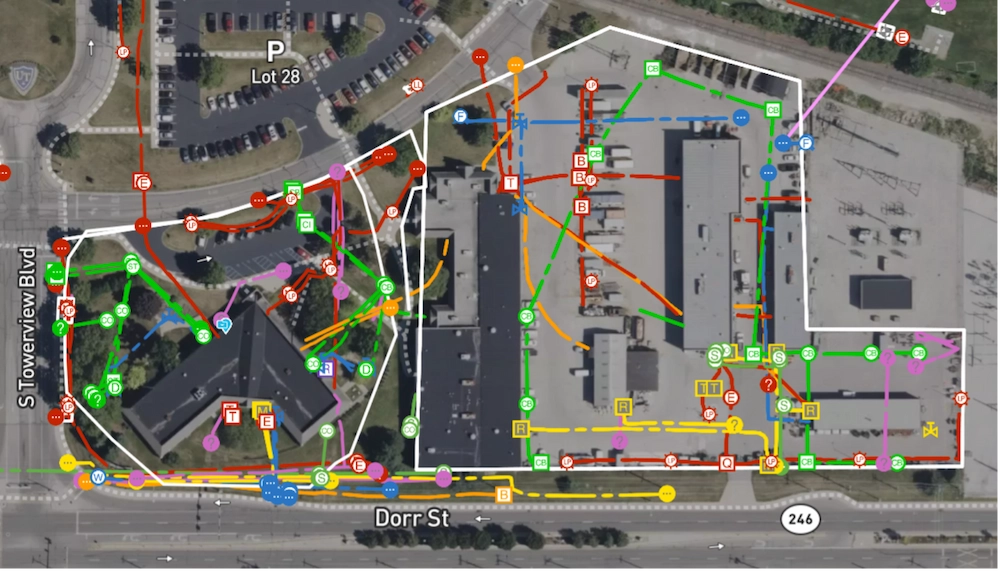
Geographic information systems provide the coordinate framework within which AR data is positioned. In utility visualization applications, GIS databases store the location, depth, and attribution data of underground infrastructure that AR platforms display as color-coded overlays. GPRS's SiteMap is built on a GIS architecture that allows utility maps, as-builts, BIM models, and reality capture data to be layered and viewed together in a single geospatial environment accessible 24 hours a day from any device.
Reality Capture and Point Cloud Integration
3D laser scanning and photogrammetry produce dense point clouds that accurately represent the geometry of existing conditions. When integrated into AR platforms, point cloud data allows users to compare design intent against actual installed conditions in real time. GPRS 3D laser scanning services produce survey-grade point clouds that feed directly into the SiteMap environment, supporting as-built verification and BIM coordination workflows on active construction sites.
Major Applications of AR in the AEC Industry
AR-enabled construction workflows apply across a broad range of AEC operations. The following applications represent the areas of greatest adoption and impact.
Subsurface Utility Visualization
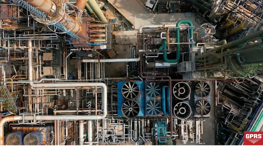
Subsurface utility visualization has become one of the fastest-growing AR applications in construction and infrastructure management, and it represents the category in which GPRS has established clear industry leadership. Traditional utility locating methods relied on aging paper as-builts, temporary spray-paint markings, and electromagnetic equipment that produced point-in-time results difficult to share or access in the field. AR systems resolve this by overlaying utility data collected through ground penetrating radar (GPR), electromagnetic locating, GIS mapping, laser scanning, and photogrammetry directly onto the physical jobsite environment as users move through it.
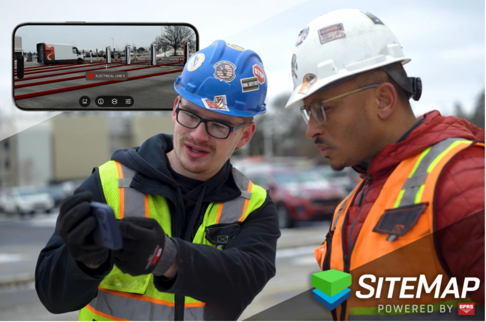
The SiteMap Mobile Augmented Reality feature allows crews to walk a jobsite or facility and see subsurface utilities in their physical space, displaying color-coded utility lines and flow direction data anchored to their actual geographic locations. Commonly visualized utilities include water mains, electrical conduits, fiber optic lines, sewer systems, natural gas pipelines, stormwater infrastructure, and post-tension cables. GPRS supports utility locating prior to soil boring and other intrusive operations by providing AR-accessible subsurface maps that protect field crews and prevent line strikes.
BIM Coordination and Clash Detection
One of the most widespread uses of AR in the AEC industry is building information modeling (BIM) visualization and coordination. AR enables project teams to place full-scale digital building models within the physical environment, allowing contractors and designers to inspect planned installations against actual site conditions before construction begins. AR-based coordination supports clash detection, installation verification, design review, prefabrication planning, and structural alignment across all trades.
Digital Twins and Facility Management
Digital twin technology has become closely associated with AR deployment in AEC environments. A digital twin is a virtual representation of a physical asset that incorporates real-time or continuously updated data. AR enables users to interact with digital twins within physical space, turning static records into dynamic operational tools accessible during maintenance, renovation planning, and emergency response. GPRS integrates 3D BIM within SiteMap by combining utility maps, BIM models, 3D point clouds, laser scans, CAD files, NASSCO-certified video pipe inspection reports, and historical as-builts into a single GIS-based visualization environment that can be used to build a comprehensive digital twin.
As-Built Verification and Construction Progress Tracking
AR systems are increasingly used to compare planned construction schedules and design documents against actual site progress. Project managers and superintendents use AR overlays to validate installation progress, document completed work, identify sequencing conflicts, and compare field conditions to BIM schedules.
GPRS as-built creation services feed directly into SiteMap, giving project teams AR-accessible records of installed utility conditions that can be compared against design documents from any mobile device. Reality capture platforms such as OpenSpace and Matterport are also commonly integrated into AR-supported progress tracking workflows.
Concrete Scanning Visualization
Concrete scanning is among the most precision-sensitive applications in construction, and AR has significantly improved how scanning results are communicated and acted upon. GPRS concrete scanning uses ground penetrating radar to locate post tension cables, rebar, conduit, and voids within concrete slabs before any coring, cutting, or anchoring work begins.
One highly-anticipated technology that is in development stages within the AEC industry is AR visualization of scan results that will allow crews to see what lies within a slab at the location where they plan to work. When this technology becomes available, it will dramatically reduce the risk of severing a post-tension cable or damaging electrical conduit embedded in the structure.
Safety and Risk Reduction
Safety improvement is among the primary drivers of AR adoption in the construction industry. AR systems reduce risk by making hazards visible that would otherwise be invisible to field personnel, including buried utilities, energized systems, structural conflicts, crane swing zones, restricted access areas, and underground storage tanks.
GPRS positions its SiteMap platform and utility locating services as central elements of a broader mission focused on 100% Subsurface Damage Prevention. When field personnel can see the location and depth of underground infrastructure before a single shovel breaks ground, the probability of a damaging or life-threatening strike drops substantially.
GPRS, SiteMap, and SIM
At GPRS, our mission is to Intelligently Visualize The Built World. Founded in 2001 and operating across all 50 states, we offer utility locating, concrete scanning, 3D laser scanning, video pipe inspection, leak detection, drone imagery, mapping and modeling, and facility data management to clients across the AEC, oil and gas, power, telecommunications, environmental, and facilities management sectors.
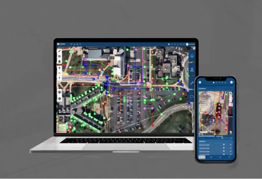
SiteMap® is our cloud-based infrastructure visualization and GIS platform. It brings together utility maps, BIM models, CAD drawings, photogrammetry, reality capture data, NASSCO reports, and other infrastructure records into one centralized, secure environment, accessible any time, from any laptop or mobile device.
The SiteMap® Mobile application takes that data off the screen and into the field. Through an AR interface, users can walk a project site and see color-coded utility lines, flow direction data, and geolocated infrastructure overlaid directly onto their physical surroundings. RTK positioning and GIS mapping keep everything aligned under active field conditions.
SIM, or SiteMap Information Modeling, is our framework for building geospatially accurate digital representations of facilities and construction environments. We combine utility locating, GIS mapping, CAD drafting, laser scanning, and BIM integration into a unified data model, delivered through the SIM Certification program, which sets the standard for subsurface data collection, integration, and delivery.
Together, SiteMap® and SIM mean that GPRS is more than a field services company. We're an infrastructure intelligence platform, giving project teams a continuous, updatable, AR-accessible record of the built environment they can rely on across every phase of a facility's lifecycle.
Where AR Shows Up in the AEC Industry
Augmented reality touches every corner of the AEC industry. Its applications reach wherever project teams must act on information about infrastructure that cannot be directly observed.
• Heavy Civil Construction: Heavy civil contractors use AR to coordinate roadway infrastructure, bridges, water systems, utility corridors, and earthwork operations. AR-assisted utility visualization is especially important in congested urban environments where utilities from multiple eras occupy limited subsurface space, often with incomplete or conflicting records.
• Oil and Gas: Oil and gas operators use AR for pipeline visualization, facility maintenance coordination, hazard identification during shutdown planning, and infrastructure inspection workflows. GPRS supports oil and gas infrastructure teams with utility locating and SiteMap visualization services tailored to energy sector demands.
• Power Distribution: Electrical utilities and power contractors use AR to visualize buried electrical lines, conduit systems, substation layouts, and utility crossings before trenching and maintenance operations. The consequences of an undetected energized line strike are severe enough that AR-based pre-excavation visualization has become a standard due diligence step at many utilities.
• Environmental and Geotechnical Engineering: Environmental consultants and geotechnical engineers use AR-supported GIS and utility visualization to plan soil borings, avoid underground conflicts during drilling, coordinate remediation activities, and document existing infrastructure. GPRS supports subsurface investigations by locating and marking buried utilities before boring programs begin, protecting field crews and preventing line strikes.
• Telecommunications: Telecommunications contractors use AR for fiber route planning, tower infrastructure coordination, underground conduit mapping, and urban utility conflict analysis. The rapid expansion of broadband and 5G infrastructure has increased demand for accurate utility visualization, particularly in dense environments where existing underground systems are extensive and records are often incomplete.
• Facilities Management: Facility managers use AR-supported digital twins to access maintenance records, locate buried utilities, and coordinate renovation work without disrupting building operations. SiteMap supports facility data management by centralizing subsurface and aboveground infrastructure records in a single AR-accessible platform.
Common Challenges and Limitations
AR implementation in construction environments presents several technical and operational challenges. Unlike structural or mechanical engineering disciplines that work with materials of precisely known properties, AR-based construction workflows depend on data quality and device performance that can vary significantly across projects.
Keeping digital models accurately aligned with physical conditions is one of the core challenges on active jobsites. GPS limitations in urban canyons and enclosed spaces, changing site conditions, calibration drift, and incomplete as-built records all introduce error. Modern AR platforms address this through RTK positioning, SLAM, and cloud-based data validation, but alignment quality is only as good as the underlying field data.
Data management adds another layer of complexity. AR workflows require large quantities of accurate, current, and well-structured data. Construction teams must manage BIM models, GIS layers, utility records, laser scans, photogrammetry datasets, and CAD files across incompatible formats. Platforms like SiteMap address this fragmentation by consolidating project information into unified geospatial environments where data can be tagged, geolocated, layered, and shared, but the quality of AR visualization ultimately depends on the discipline with which field data is collected and maintained.
Field adoption has historically run into complex hardware requirements, training demands, poor usability in outdoor conditions, and spotty connectivity on remote or enclosed sites. The industry has largely moved past this by shifting to tablet- and smartphone-based AR workflows built around hardware field crews already carry. The SiteMap Mobile App is built on that same principle, targeting standard iOS and Android devices rather than specialized AR headsets or wearables.
Tools and Technology in AR-Enabled Construction
Modern AR deployment in AEC has been shaped by advances in mobile computing, geospatial platforms, and field sensing technologies. These tools give project teams far greater ability to act on subsurface and structural information at the point of need, without replacing the professional judgment behind every decision.
Ground penetrating radar and electromagnetic locating equipment remain the primary field technologies for collecting the subsurface data that AR systems display. GPRS employs professional-grade GPR systems and trained project managers to produce utility maps with a reported at-fault incident rate of <0.20% since 2017, or over 1 million jobs (a standard that is fundamental to the reliability of AR utility overlays in the field). 3D laser scanning produces survey-grade point clouds that support as-built verification and BIM comparison workflows. Video pipe inspection using NASSCO-certified software provides condition assessment data that feeds directly into SiteMap alongside utility location records.
GIS platforms provide the spatial framework within which AR data is positioned and served to mobile devices. Cloud-based project management systems allow updates made in the field to be immediately accessible to all project stakeholders regardless of location. GPRS' SiteMap platform integrates these technologies into a unified environment that supports as-built creation, mapping and modeling, and facility data management alongside AR visualization, giving project teams a single source of truth for both field and office workflows.
Artificial intelligence is beginning to enter AR-enabled construction platforms for object recognition, automated progress tracking, predictive maintenance, clash detection, and risk analysis. AI-assisted workflows are expected to improve the accuracy and usability of AR systems over time, reducing the manual effort required to maintain alignment between digital records and physical conditions. GPRS supports these evolving workflows with trained field teams capable of scanning, locating, and documenting subsurface conditions across a wide range of project types and terrain.
Where the Field Is Headed
Several trends are reshaping how AR is used across the AEC industry. Spatial computing, which combines AR, GIS, AI, BIM, and real-world sensing into unified interactive environments, is pushing investment toward mobile-first platforms and connected project ecosystems. Construction firms increasingly want workflows that let field personnel interact with project information directly in physical space, rather than relying on desktop software that puts distance between the model and the field.
Wearable AR systems, including smart glasses capable of displaying BIM overlays and utility maps within a field technician's line of sight, are maturing toward practical construction use. While tablet- and phone-based AR dominates current deployment, hands-free AR is expected to become viable for specific AEC applications as battery life, display quality, and ruggedness continue to improve.
Cities with layered, aging underground infrastructure are raising the bar for subsurface engineering precision. As development increases in cities where existing infrastructure is layered from multiple eras and accurate records are scarce, the ability to visualize subsurface conditions in AR before excavating or building has become more important than ever. The combination of professional utility locating services and AR-accessible data platforms is the most reliable path to that capability.
Future AR applications in AEC are expected to include real-time construction analytics, autonomous equipment integration, persistent spatial computing environments, AI-assisted infrastructure inspection, and continuously updated digital twins that reflect field conditions as they change. GPRS, through SiteMap and the SIM framework, has built the infrastructure intelligence platform that makes that visualization possible today, grounding it in field data collected to the standard of accuracy that the industry requires.
The Bottom Line
Augmented reality tends to go unannounced.
It works in the background of daily construction operations: in the moment a field crew member pulls up a utility overlay before setting up a drill rig, or when a facility manager checks the SiteMap Mobile App before authorizing a core through a concrete floor. Its value shows up as utility strikes avoided, rework caught before it gets built, and coordination failures resolved in the model before they reach the field.
The more complex construction projects become, and the denser subsurface infrastructure grows, the more critical accurate, accessible AR visualization becomes. GPRS, through SiteMap and the SIM framework, delivers that visualization grounded in field data collected to a standard of accuracy that the industry demands.
Every structure standing on solid ground does so because someone first figured out what lay beneath it. Augmented reality is the technology making that knowledge visible, in real time, at the point of work.
Contact GPRS to learn how utility locating, SiteMap, and SIM services can support your next construction or infrastructure project.
Frequently Asked Questions: Augmented Reality in the AEC Industry
What is augmented reality in construction?
Augmented reality in construction refers to the use of mobile devices, tablets, or wearable displays to overlay georeferenced digital information, including utility maps, BIM models, GIS layers, and 3D point clouds, onto a live view of the physical environment. Unlike virtual reality, AR supplements the real world rather than replacing it, giving field crews simultaneous visibility of their actual jobsite and the digital data relevant to their work at that location.
How does AR help prevent utility strikes?
AR platforms overlay utility location data collected through ground penetrating radar (GPR), electromagnetic locating, and GIS mapping directly onto the physical jobsite as crews move through it. Instead of mentally translating a 2D utility map into 3D space, field personnel can see exactly where underground utilities are in relation to their planned excavation. SiteMap Mobile Augmented Reality by GPRS provides this capability, displaying utility location, depth, and flow direction at the point of work.
What is SiteMap and how does it use augmented reality?
SiteMap is GPRS' cloud-based infrastructure visualization and GIS platform. It aggregates utility maps, BIM models, CAD drawings, 3D point clouds, photogrammetry, and NASSCO video pipe inspection reports into a centralized, secure environment accessible 24/7 from any device. The SiteMap Mobile application includes an AR feature that overlays color-coded utility lines and flow direction data onto the live camera view of a mobile device, anchored to real-world geographic coordinates through RTK positioning. Learn more at gp-radar.com/sitemap.
What industries benefit most from AR in construction?
AR provides operational value across the full range of AEC sectors. Heavy civil contractors benefit from utility visualization in congested urban environments. Oil and gas operators use AR for pipeline visualization and shutdown planning. Environmental and geotechnical engineers use AR-supported GIS to plan soil borings and coordinate remediation. Telecommunications contractors use AR for fiber route planning and utility conflict analysis. Facility managers use AR-enabled digital twins for maintenance coordination and renovation planning. Any workflow requiring field crews to act on subsurface or structural information at the point of work benefits from AR.
How accurate is AR utility visualization?
Accuracy depends on the quality of the underlying data and the positioning technology used. GPRS utility locating services produce results with the highest level of accuracy within the industry, and SiteMap Mobile incorporates RTK positioning to maintain geographic alignment between utility overlays and their actual subsurface locations. This level of accuracy is significantly higher than what is achievable through 811 call-before-you-dig services alone, which typically provide approximate utility corridor locations rather than precisely mapped routes with depth information.
What is the ROI of augmented reality in construction?
The return on investment for AR in construction is driven primarily by rework reduction, utility strike prevention, and improved coordination efficiency. Research from FMI Corporation estimates that rework accounts for approximately 30% of all work conducted on U.S. construction projects, much of it attributable to coordination failures that AR-based clash detection and BIM overlay workflows can prevent. Utility strikes carry direct costs including repair expenses, project delays, regulatory penalties, and potential liability, in addition to the serious safety consequences of a strike on an energized line. AR platforms that prevent a single significant utility strike on a major project typically justify their cost many times over.
How does GPRS support AR workflows on construction projects?
GPRS provides the field data that makes AR visualization meaningful. Ground penetrating radar and electromagnetic locating produce the subsurface utility maps that SiteMap displays as AR overlays. 3D laser scanning produces the point clouds that support as-built verification and BIM comparison. Video pipe inspection, concrete scanning, and leak detection results are stored in SiteMap alongside utility data, creating a comprehensive, AR-accessible record of infrastructure conditions. Contact GPRS to discuss how these services can support your project.