

.svg)
WHAT IS THE HIGH-SPEED 3D GPR ARRAY?
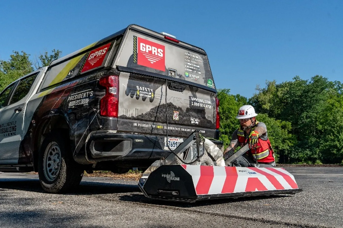
The high-speed 3D GPR array is one of the most powerful applications of GPR technology. This specialized system features over a dozen antennas and the ability to collect large amounts of subsurface data at high speeds, which are automatically compiled into 3D images that can be viewed and quality controlled on site.
PRIMARY USES AND APPLICATIONS
The GPR array can be most useful anywhere you would need to map miles of utilities quickly. Anywhere from highways and right-of-ways to pipelines and wind farms, the high-speed 3D GPR array can help.
Understanding the location of underground utilities is vital when planning a construction, renovation, or restoration project. And if your next project involves miles of road or hundreds of acres of land, the GPR array is your secret weapon to show you what you need to see when you need to see it.
Once the scans are completed, CAD technicians, like GPRS’ in-house Mapping & Modeling team, analyze all of the data to find the utility data, so they can extract those lines and create deliverables like CAD drawings and utility maps. This takes several passes and the use of specific types of software, so it’s always vital to have professionals perform this task to ensure they translate the data accurately.
Once the scan data is “cleaned up,” the subsurface utility maps and information are uploaded to SiteMap® (patent pending), GPRS’ cloud-based infrastructure platform that helps you manage your build world. With SiteMap, all your underground utility data is securely stored in one place and is geospatially accurate to allow for enhanced analysis and collaboration capabilities.
The applications of the GPR array don’t stop at utility mapping. While scanning and mapping utilities are some of GPRS’ calling cards, the GPR array’s capabilities can do much more for architecture, engineering, and construction (AEC) industry projects.
GPRS Project Managers can use the GPR array, similarly to pushcarts and handheld GPR devices, to scan concrete and identify reinforcements. Identifying objects like rebar, potential voids, post tension cables, and other subsurface features is vital when cutting or coring concrete. If someone severs one of those features, especially post tension cables, projects can face severe delays, get hit with high repair bills, and put team members at risk of fatal injuries. Project Managers can scan and map areas with long stretches of concrete, like multi-story parking garages, in minutes instead of hours.
Another way AEC industries can benefit from the GPR array is right-of-way engineering. Civil and design engineers are required to manage the physical location for infrastructure projects like roadways, utilities, and pipelines. That management can include the acquisition of rights, preparing maps and legal descriptions, legal compliance, and surveying. The GPR array can gather data and information that would be vital for properly managing these locations.
The GPR array can aid other areas in the AEC industry, including:
- Road, bridge, and infrastructure surveys
- Underground storage tank (UST) and subsurface anomaly investigation
- Environmental assessments
- Mineral exploration & mining
Outside of the AEC industry, the high-speed 3D GPR array can even be used for archaeological surveys, forensic investigations, and the identification of unexploded ordnances for the military.
It is important to note that GPRS is not a surveying company. GPRS has the nation’s leading utility locating accuracy rate at 99.8% and provides utility maps that support SUE Level B Quality Standards, which can also include utility type, size, material, and other characteristics of underground infrastructure.
WHAT ARE THE BENEFITS OF USING THE GPR ARRAY?
When asked what the primary benefits and advantages of utilizing the high-speed 3D GPR array are, GPRS Senior Vice President of Field Support, Jamie Althauser, stated the following.
“There are several [benefits], but one of them would be the ability to collect data at driving speeds instead of using the pushcart and the ability to collect data with a wide swath at a time. The speed of collection overall and the ability to cover very large scopes quickly - both the amount of data you're collecting and the speed at which you're collecting it - adds up to an exponential increase in speed of data collection in the field. That is one huge advantage of it - that's the primary advantage.”
Althauser also explained some of the other benefits of utilizing the GPR array.
“Another benefit would be the fact that you're collecting a ton of data at once, compiling it all, and both processing it and looking at it in the office at a computer instead of trying to interpret it in the field. When you get to have the perspective of looking at all of it at once, compiled on a computer screen, it could increase your chances of seeing a pipe that you may have missed otherwise, so the quality of results can increase.”
HOW DOES IT DIFFER FROM TYPICAL GPR?
GPR units use antennas, also referred to as GPR channels, to detect underground objects.
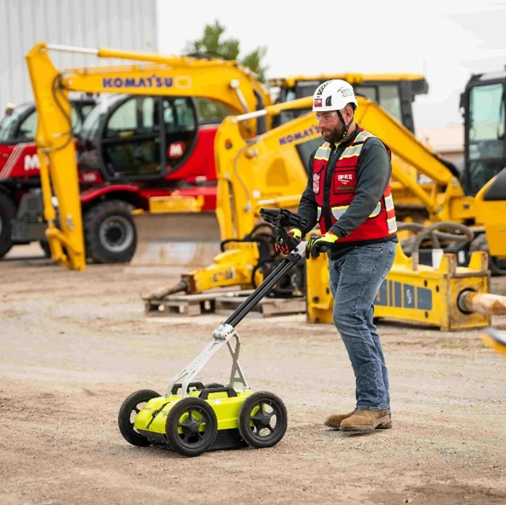
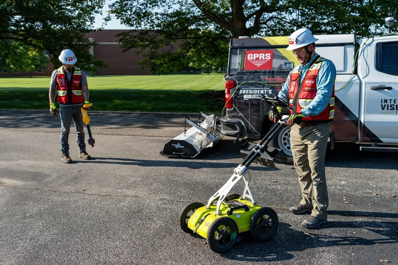
GPR push carts commonly utilized by GPRS Project Managers feature dual-channel technology. One channel is at a lower frequency (around 400 MHz) to penetrate deeper into the ground, and another is at a higher frequency (around 800 MHz) to collect finer details and locate smaller objects.
The GPR array expands on that exponentially by featuring 18 channels of GPR. Each antenna is spaced 5 cm apart and placed at the same frequency. The large number of channels allows for faster scan times with a wider range of collection.
The array has two antenna variations: 45 and 80. The 45 has a 450 MHz frequency, which is suitable for utility mapping, railways, and archaeological purposes. The 80 sports an 800 MHz frequency suitable for mapping road layers and scanning concrete. However, unlike the dual-channel technology used in push carts, all 18 channels must be set to the same frequency.
As mentioned previously, the biggest advantages of the GPR array are its capabilities at driving speeds. It can collect images at speeds up to 80 mph or 130 km/h. This allows for data collection on roads, bridges, or highways without the need for traffic management or delays. Using a typical GPR pushcart in the same area would take longer and require road closures during the scanning process.
The speed and efficiency of the GPR array’s data collection is undeniable. However, there are some aspects that are not involved in the scanning process, including:
Each of these factors are used with traditional GPR by GPRS Project Managers to perform scans in the field, use their expertise to examine each hyperbola, and see if they need to conduct additional scans. Project Managers can also use them after scanning an area with the GPR array to uncover anything it may have missed during the initial scan.
Even though some aspects are not included during investigations with the GPR array, the use of Real-Time Kinematic (RTK) positioning helps confirm the results are accurate within a few centimeters.
It is important to understand that the GPR array is not a one-size-fits-all solution for underground utility and concrete scanning.
One of the main guidelines of SIM, the standard operating procedure that guides every GPRS Project Manager, is the use of complementary technologies when locating buried utilities or scanning a concrete slab. Examples of these complementary technologies are GPR and EM locators. By combining the GPR array with our well-established utility locating methods, GPRS Project Managers can sustain our 99.8% accurate subsurface utility scans with wider scan ranges and quicker turnarounds.
HOW DOES THE GPR ARRAY ELEVATE GPRS’ SERVICES?
GPRS added the GPR array to the toolbelt of Project Managers in the summer of 2025 and it made an immediate impact. Its high-speed data collection capabilities have helped our team Visualize the Built World® for our customers in a fraction of the time it would take with traditional methods.
One example of the GPR array elevating our utility locating services is when we located utilities across 0.6 miles of a three-lane, high-speed road in Charlotte, North Carolina.
With the GPR array, GPRS Project Managers located 171 subsurface utility lines in less than an hour without disrupting traffic flow.
.webp)
However, as previously mentioned, the GPR array is not the one and only solution. The client needed a comprehensive map of the entire area. By following the guidelines of SIM and utilizing complementary technologies, GPRS was able to locate, identify, track, and log far more utilities than the GPR array alone.
Another project that utilized the GPR array was when GPRS provided a thorough map of a complex drain line system over 530 acres of land. To effectively plan the construction of a new data center in the Midwest, they immediately needed to know the location of key drain lines across 530 of the 1,500-acre site. With a complete map of the initial 530 acres, GPRS and the client can gain an understanding of the remaining 1,000 acres more easily.
With the use of the GPR array and traditional GPR methods, two Project Managers mapped out all 530 acres of drainage lines in only 46 days. Our multi-phase approach allowed the client to continue the construction process without any surprises. Additional phases may include scaling the GPR array over the remaining 1,000 project acres. Without the GPR array, the process could have taken twice as long.
From acres of land to hundreds of stories, GPRS Visualizes the Built World® to keep your projects on time, on budget, and safe.
What can we help you visualize?
FREQUENTLY ASKED QUESTIONS
Is the GPR Array a Reality Capture Service?
Even though “3D” is in the name, the high-speed 3D GPR array does not fall into the categories of reality capture or 3D laser scanning.
The reason why “3D” is included in the name is because of the way the data is captured. Several 2D readings are compiled into one three-dimensional view of the scanned area, hence the inclusion of 3D in the name.
While traditional 2D GPR scans can create 3D objects with the help of CAD technicians, the GPR array provides the 3D image automatically.
What is Subsurface Investigation Methodology?
Subsurface Investigation Methodology (SIM) is a standard operating procedure and set of professional specifications that work as a guide for utility locating experts when scanning for buried utility lines. All GPRS Project Managers are required to achieve SIM 101 certification, which requires 80 hours of hands-on training in a classroom setting and 320 hours of mentorship in the field. For reference, the American Society for Nondestructive Testing’s (ASNT) minimum training recommendation includes eight hours for training and 60 hours practicing GPR to achieve NDT Level 1 certification in ground penetrating radar (GPR) scanning.
SIM requires the use of multiple, complementary technologies, like GPR scanning and electromagnetic (EM) locating, when locating buried utilities or scanning a concrete slab.
What types of deliverables do I get when I hire GPRS to conduct a utility locate?
Our Project Managers flag and paint our findings directly on the surface. This method of communication is the most accurate form of marking when excavation is expected to commence within a few days of service. GPRS also uses Real-Time Kinematic (RTK) Positioning and Robotic Total Stations (RTS) to collect data points of findings. We use this data to generate a plan, KMZ file, satellite overlay, or CAD file to permanently preserve results for future use. GPRS does not provide land surveying services.