

.svg)
Historic buildings rarely conform to clean drawings or straight lines. They bow, lean, twist, and carry layers of change that standard documentation often misses. That’s exactly why HBIM (Historic or Heritage Building Information Modeling) has gained traction. It combines precise reality capture, such as 3D laser scanning, with BIM standards. This results in useful digital records that owners, designers, and conservators can rely on.
In this guide, we’ll cover HBIM. We’ll trace its origins and outline the entire workflow. We’ll also show how a professional service like GPRS can combine scan-to-BIM and scan-to-CAD for historic preservation.
HBIM in One Sentence
According to Springer Nature, “Historical Building Information Modelling (HBIM) is an approach that combines innovative technology with historical preservation to recreate and document historical buildings.”
What Are the Origins of HBIM?
The concept of HBIM crystallized in academic and practice-based research in the late 2000s and 2010s. Murphy, McGovern, and Pavia created important work that framed HBIM as a library. This library features parametric objects based on historic architectural sources like Vitruvius to Palladio. The elements can then be mapped onto point clouds captured via terrestrial laser scanning or photogrammetry.
The goal wasn’t just pretty models. It was conservation documentation: sections, schedules, and construction details that reflect how heritage elements were actually built.
.webp)
Recent literature reviews stress that information requirements and standardization are still maturing. Many case studies show limited operational use.
According to ResearchGate, “Previous case studies have attempted to adapt BIM procedures to HBIM [58], but these have generally been considered failures because BIM was primarily created for construction use.” At the start of each project, it’s important to clearly outline the tolerances and level of detail (LOD).
What is the Difference Between HBIM vs BIM?
At first glance, HBIM and BIM sound similar. They both create digital models and manage building data. But their goals and workflows are very different.
BIM’s primary focus was for modern buildings, where everything is standardized: walls are straight, components follow manufacturer specs, and design data flows neatly from concept to construction. It’s all about efficiency, coordination, and cost control in modern projects.
HBIM starts with reality capture, laser scanning, and photogrammetry to record what’s actually there. HBIM uses custom parametric objects instead of standard BIM libraries. These objects reflect historic architectural styles, like Palladian columns and Gothic arches.
The goal isn’t just design coordination. It’s conservation, research, and lifecycle management. HBIM models hold historical data, material details, and archival references. They serve as a living record for restoration and heritage preservation.
Why Owners and Project Teams Invest in HBIM
HBIM is a response to three persistent realities:
- Historic assets change over time in ways that drawings hardly reflect.
- Stakeholders need measurable, actionable data to plan interventions.
- Inaccurate as-built drawings lead to costly rework. HBIM, when paired with 3D laser scanning, provides point clouds with millimeter-level accuracy. These point clouds support scan-to-BIM models and as-built drawings. This combination cuts down on site revisits and reduces change orders.
The U.S. National Park Service (HABS/HAER/HALS) points out that laser scanning offers great accuracy. It saves time, too, especially in hard-to-reach areas. The guidelines also emphasize that as-built drawings are essential for long-term permanence.
Historic England mentions the benefits around collaboration, asset management, and lifecycle information. BIM ultimately minimizes project risk and enhances efficiency.
Using BIM in heritage projects offers advantages for both construction (CAPEX) and ongoing maintenance (OPEX). This is like what we see in new-build projects. Academic research backs this up, too – historic BIM helps teams investigate and understand old structures more accurately. This leads to better planning, fewer surprises, and informed conservation strategies.
What Are the Use Cases of HBIM?
HBIM is more than a digital modeling tool; it’s a strategic solution for heritage challenges. One major use case is creating a digital record of cultural heritage assets. Historic buildings often lack accurate documentation, making restoration risky and expensive. HBIM solves this by capturing accurate geometry and metadata. This helps architects and conservators plan interventions with confidence. This cuts down errors, protects fragile structures, and helps meet preservation standards.
Another critical use case is informed decision-making and resource management. HBIM models contain valuable data on materials, conditions, and maintenance history. This transforms them into dynamic databases for lifecycle management.
Facility managers can schedule preventive maintenance, track deterioration, and optimize budgets. HBIM is valuable for researchers and heritage organizations. They utilize it for analysis and virtual reconstructions. It also boosts public engagement through immersive tours and educational content. In short, HBIM transforms heritage assets into actionable, data-driven resources that serve owners, conservators, and communities for decades.
What is the HBIM Workflow?
1. Plan the Information You Actually Need
Think about how the owner, designer, fabricator, and facilities team will use the data. This aligns with ISO 19650 concepts such as clearly stated Exchange Information Requirements (EIR), Asset Information Requirements (AIR), roles and responsibilities, and a Common Data Environment (CDE) to manage the flow of models and documents.
2. Data Collection
For heritage assets, GPRS Project Managers typically deploy:
- LiDAR-based scanners
- Tripod-mounted or mobile SLAM LiDAR
- Photogrammetry-based scanners
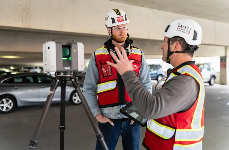
The U.S. NPS notes they now use laser scanning on nearly every project due to accuracy and efficiency.
3. Registration and Point Cloud Processing
Scans are registered into a unified coordinate system to remove noise. LiDAR 3D laser scanners gather millions of points each second. This creates dense clouds that you can navigate, measure, and section. Tools like Autodesk’s ReCap have extensive usage in preparing point clouds for Revit and other BIM platforms.
4. HBIM Model Development
Next, you will convert point clouds into a parametric or hybrid BIM model. Since historic buildings don’t fit standard BIM libraries, you often need to create custom families for arches, vaults, and decorative elements.
5. Information Management and Delivery
Package the data according to ISO 19650 principles with clear statuses in the CDE, like work in progress, shared, published, and archived. Historic England offers templates and methods to help heritage owners use BIM. This guidance supports the creation of an Asset Information Model (AIM) for ongoing conservation.
Why is 3D Laser Scanning the Backbone of HBIM?
3D laser scanning remains the backbone of HBIM because it captures complex geometry in a quick and safe manner, even in fragile spaces. It produces measurable, repeatable records.
Industry primers define reality capture as the digitization of existing conditions using LiDAR, photogrammetry, and 360° imaging, followed by the integration of that data into BIM to enhance design efficiency and cut rework.
HBIM shows remarkable accuracy and reliability in documenting historic buildings. Studies and real-world projects highlight its effectiveness, especially where traditional methods fall short. Ornamental details, irregular geometry, and hard-to-reach areas often make manual measurement a challenge.
Teams used tools like tape measures, cameras, and handheld “distos” in the past. This approach took hours of labor and had plenty of room for errors. These methods were slow, fragmented, and often missed critical details. HBIM changes the game by using laser scanning and photogrammetry to capture millions of data points in minutes. This ultimately creates a precise digital record that is far more efficient and dependable.
What Are Typical HBIM Deliverables?
- Registered Point Clouds: High-accuracy 3D data sets captured by laser scanning, cleaned and aligned for modeling.
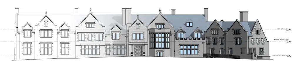
- 2D As-Built Drawings: Plans, elevations, and sections derived from the point cloud for documentation and permits.
- Scan-to-BIM Models: Intelligent 3D Revit models plus structured data for an Asset Information Model (AIM).
- Visual Tools for Remote Access: TruViews or virtual tours that allow stakeholders to explore the site without being on-site.
- Specialty Heritage Outputs: Deformation maps, condition annotations, and HABS/HAER/HALS-compliant drawing sets for archival submission.
%20(1).webp)
Case Study: Restoring Frank Lloyd Wright’s Unity Temple
Located in Oak Park, just outside Chicago, Unity Temple is one of Frank Lloyd Wright’s most iconic works and a National Historic Landmark.

The solution? Using laser scanning and BIM modeling, GPRS Project Managers documented the temple’s interior, exterior, roof, and skylights. The GPRS Mapping & Modeling Team turned the point cloud data into a 3D Revit model. This model assists contractors and designers in planning restoration work with precision.
The payoff was huge. The colorized point cloud and BIM model preserved fragile architectural features digitally. This helped reduce the risk of damage during construction. Plus, TruViews and CAD deliverables streamlined collaboration, cutting down on site visits and ensuring Unity Temple’s aesthetics and spatial design remained intact.
You can read the full case study here.
Why Choose GPRS for Your Historic Preservation Projects?
If you need a professional service provider to document your most valuable assets, GPRS has you covered. We combine 3D laser scanning with Mapping & Modeling services. This approach creates point clouds, as-built drawings, and BIM models with 2–6 mm accuracy. This is scalable for architectural, structural, and MEP scopes. GPRS’ expert “boots on the ground” Project Managers operate nationwide with standardized processes built around Subsurface Investigation Methodology (SIM) certification.
This comprehensive program establishes protocols for utility locating, concrete scanning, and 3D laser scanning that surpass industry benchmarks. It features 80 hours of classroom instruction, 320 hours of field mentorship, and an additional 40 hours dedicated to LiDAR training. This ensures mastery of scanning technologies and their practical applications.
GPRS’s reality capture services emphasize turning point clouds into intelligent models to support design, visualization, prefabrication, and clash detection. This is a practical way to cut risk in interventions in dense, historic plant rooms, theaters, or civic buildings.
What can we help you visualize?
Frequently Asked Questions
How long does 3D laser scanning take?
GPRS has Project Managers across the country, allowing us to respond quickly with detailed quotes. Most jobs can be scanned in just a few hours, while larger sites may take a few days. Scanning entire facilities or campuses can take weeks. Yet, most projects are completed in hours or days.
How does GPRS integrate 3D laser scanning to deliver scan to BIM and scan to CAD?
GPRS deploys construction-grade LiDAR scanners to capture high accuracy point clouds, then the Mapping & Modeling team converts those clouds into Revit (BIM) models and 2D CAD drawings per your scope. The same dataset can feed clash detection and prefabrication workflows, so you can avoid costly change orders and delays.
What accuracy and deliverables should I expect?
Typical construction grade scans support 2–6 mm accuracy for interior architecture and MEP, with deliverables ranging from registered point clouds to as built drawings and BIM models. GPRS can tailor the level of detail to your use case (design, fabrication, facility management) and customize deliverables to your project’s requirements.