

.svg)
Founded in August of 1852, St. Elizabeth’s Hospital in Washington, D.C. has an infamous history. Initially known as the “Government Hospital for the Insane,” it was the first federally funded mental hospital in the United States and served as a general hospital for the U.S. Navy during the Civil War.
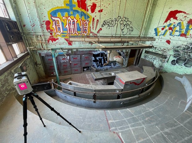
One of the most notorious aspects of this hospital’s history is the autopsy theater in the basement of the Blackburn Laboratory. Built in 1924, this building served as the facility’s main medical science center. Their doctors conducted thousands of autopsies in the basement of that building. The research conducted during these examinations eventually led Dr. Walter Freeman to develop “ice pick” lobotomies that were most notably performed on JFK’s sister, Rosemary.
The abandonment of the facility happened gradually over decades due to medication and legislature targeted towards mental health issues. It was downsized continually starting in the 1960s until all remaining patients were transferred to other facilities in 2002.
During its decline, it was designated as a National Historic Landmark (NHL) in 1990 by the U.S. Department of the Interior for pioneering psychiatric architecture.
It’s undergone many years of renovations to keep the buildings standing across the 350-acre campus.
Its latest project involved the relocation of the Blackburn Laboratory building to make way for a nearby street extension. Since it is recognized as a structure with historical significance, they can’t simply demo it; they need to move it 65 feet away from its current location.
The process of relocating historic structures is complex one that involves extensive surveys, analysis, and documentation. The best place to start is by assessing the building’s current condition and documenting it thoroughly for record keeping purposes.
For the Blackburn Laboratory project, Bell Architects, the firm hired to evaluate the building, needed a clear picture of its structural integrity. Without any recent as-builts or documentation to go off of, they called GPRS.
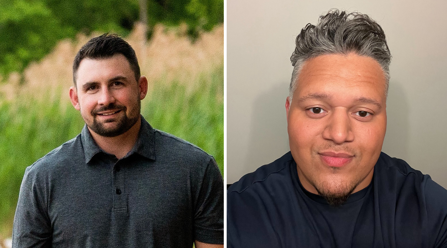
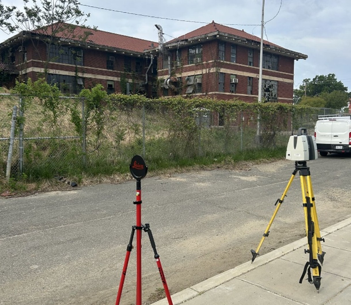
GPRS Reality Capture Project Managers Vincent Paul and Marco Prado were tasked with scanning the interior and exterior of the building. Over an eerie three days, they captured every inch of the abandoned facility using LiDAR-based 3D laser scanners.
One challenge they encountered was a set of garages that were inaccessible due to plywood covering the doors. Paul coordinated with the site contact to schedule a follow-up scan of the remaining areas a few months later to ensure nothing was undocumented.
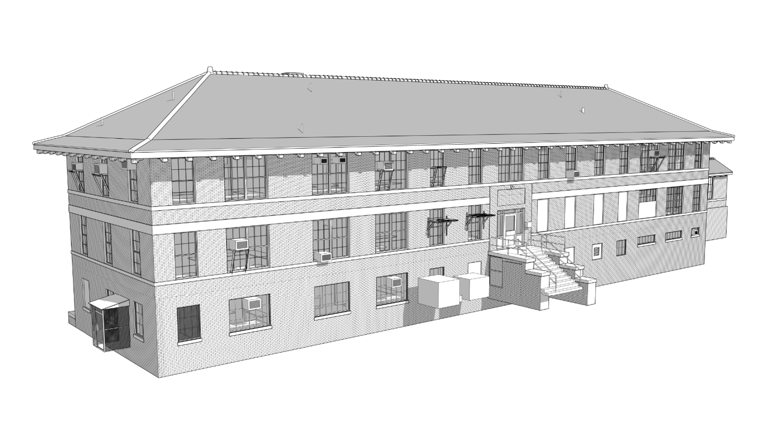
With the point cloud file developed from all the scan data, the job shifted to GPRS’ in-house Mapping & Modeling Team to turn the scan data into 2-6 mm accurate as-built drawings and 3D models.
Our team utilized survey control points during the scanning process, which adds an additional layer of accuracy and reliability to our deliverables. GPRS CAD Technician Attilio Gentile III, who worked on this project, explains the benefits of control points: “The models and/or drawings are more accurate and have greater utility in conjunction with other projects. Any other architectural projects, existing surveys tied to the same coordinates can import our 3D model and/or CAD files and use it however they please in the future tied to that specific location.”

This additional level of accuracy and convenience will serve Bell Architects and anyone else who works on this property moving forward well, allowing for the best possible care for the historic building.
The suite of deliverables we provided to Bell Architects included:
- 3D Revit Model with CAD export
- Reflected Ceiling Plans (RCP)
- Exterior Elevation Plans
- Floor Plans
The project is still progressing, and the relocation date is currently scheduled for October 30, 2026, which will no doubt be a memorable Halloween Eve for the teams involved.
From skyscrapers to sewer lines, GPRS Visualizes the Built World®, above and below-ground, to ensure your projects stay on time, on budget, and safe.
FREQUENTLY ASKED QUESTIONS
WHAT IS LIDAR?
LiDAR (Light Detection and Ranging) is a remote sensing tool that builds accurate 3D models of objects and surfaces.
Instead of using radio waves like radar, LiDAR sends out laser pulses from a scanner. These light pulses bounce off objects, and the system measures how long they take to return. This helps calculate exact distances and shapes. It creates detailed three-dimensional data about an object.
Learn more about LiDAR and how GPRS utilizes LiDAR laser scanners here.
WHAT IS POINT CLOUD DATA?
Point cloud data is the term for data points collected by LiDAR-based laser scanners.
Each point stores X, Y, and Z coordinates for visible surfaces like walls, doors, and MEP components.
The data points are used by GPRS’ in-house Mapping & Modeling Team to create customized 2D and 3D deliverables for clients.
Learn more about GPRS’ Point Cloud Services here.
WHAT IS SIM?
Subsurface Investigation Methodology (SIM) is a standard operating procedure and set of professional specifications that work as a guide for utility locating experts when scanning for buried utility lines. All GPRS Project Managers are required to achieve SIM 101 certification, which requires 80 hours of hands-on training in a classroom setting and 320 hours of mentorship in the field. For reference, the American Society for Nondestructive Testing’s (ASNT) minimum training recommendation includes eight hours for training and 60 hours practicing GPR to achieve NDT Level 1 certification in ground penetrating radar (GPR) scanning.
SIM requires the use of multiple, complementary technologies, like GPR scanning and electromagnetic (EM) locating, when locating buried utilities or scanning a concrete slab.
WHAT REALITY CAPTURE DELIVERABLES CAN GPRS PROVIDE?
GPRS can deliver point cloud data in many formats, including:
• 3D Mesh Models
We can also deliver the following customizable deliverables upon request:
• Aerial Photogrammetry
• Digital Drawings of GPR Markings
• At-Depth Modeling
• Native Modeling
• New Construction Accuracy Analysis/Comparative Analysis
• Point Cloud Modeling Training Webinars
• Reconciliation of Clients 2D Design Drawings
• Reconciliation of Clients 3D Design Model
• Structural Steel Shape Probability Analysis
• Template Modeling
• Volume Calculations
Schedule a service with our Reality Capture Project Managers here.