

.svg)
Outdoor Utility
Tracking underground utilities is impossible without accurate and thorough documentation. GPRS locates utilities, marks their location, and collects GPS coordinates on those utilities. We provide complimentary high-resolution maps in the form of PDF, KMZ, and SHP files with every outdoor utility locating project we perform. These maps are vital for keeping an accurate record of utilities’ locations for future construction work. Data can be processed into additional maps and models.

Field Markings & GPS Mapping
Clients receive field markings in the form of paint, pin flags, stakes, or any other method they request. Additionally, each GPRS Project Manager creates a GPS map with detailed marking located on appropriate coordinate systems and produces automated maps for outdoor utility locates. Deliverables will be sent via email and will include a link to a free SiteMap personal subscription to access, store and securely share site data.
Deliverable: Field markings and a submittal letter with links to download printable PDF map, KMZ, and SHP files. SiteMap link where applicable.
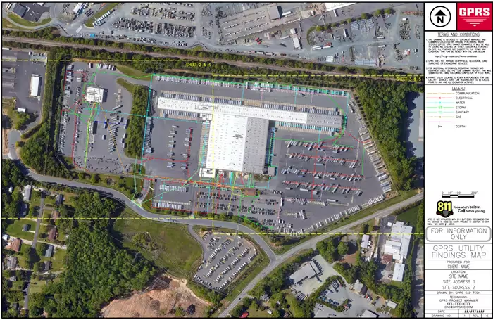
Outdoor Utility CAD
GPRS can create CAD files documenting our outdoor utility locating results. The CAD files come ready to use with annotation and scaling, saving clients’ resources and time. Contractors, engineers, and owners can quickly develop or update as-built drawings. Clients use these files for preplanning, to avoid utilities, or to document the history of their site on various CAD and GIS systems.
Deliverable: DWG and/or DGN CAD files, JPEG image files, and a 2D CAD PDF.

Drone Imagery CAD
GPRS has access to a drone pilot network that provides aerial imagery for your project site as an additional service across the country. Our drones allow us to create high-quality aerial images showing GPRS paint and markers on the ground and the on-site conditions at the time of flight. The drones can fly in and record immediately after we finish marking the field.
Deliverable: DWG and/or DGN CAD files, drone background image geo TIF file, an obj mesh file, an XYZ point cloud, and a 2D CAD PDF.

EMI Data Processing
GPRS Mapping and Modeling Team processes EMI data to generate heatmap KMZs and Images showing possible subsurface metallic and non-metallic hotspots for PM reports and further GPR investigation. This processed data can also be overlaid on utility CADs as the aerial image.

SiteMap
A personal SiteMap subscription is free with any GPRS utility locate. SiteMap is an online digital storage platform that houses GPRS maps, models, and site data. Upon completion of your project, an email will be sent with a link to the SiteMap login for clients to create an account and securely access, store, and share site data.

3D Virtual Tour
GPRS can implement 3D Cameras or 3D Laser Scanners at your site to document all the interior findings. GPRS uses these cameras to create a floor plan of your site with our results added as linework, or to create 3D views and point clouds. Our 3D virtual tour utility lets your team tour the location, add digital notes, and even measure inside the point cloud viewer.
Deliverable: 90 day access to the virtual tour site (this access can be extended as needed).