

.svg)
3D Laser Scanning
GPRS offers a wide range of 3D laser scanning, photogrammetry, and visualization services. We work closely with each client to define the project scope and use the right tools to achieve the accuracy and deliverables needed to successfully complete each project. Beyond the raw point cloud data, we provide virtual tours, 2D CAD sheets, 3D meshes, and 3D BIM models to the highest quality standards. Projects are uploaded to easy-to use cloud-based data platforms, delivered via Sharefile or sent on a hard drive.

Point Cloud Data (Raw Data)
A point cloud is the set of 3D data points captured by the laser scanner. It contains the X, Y, and Z coordinates of every visible detail of a project site. These include objects like doors, windows, walls, MEP equipment, ductwork, and steel structures, to name a few. You can import the point cloud into CAD software to visualize the area. The data will look like a pixelated, digital version of your site. Once imported, point cloud data can be parsed, manipulated, and modified to suit a client’s needs.
Deliverable: PTG point cloud files and Autodesk Recap files in .RCS and .RCP format.
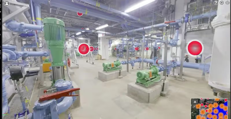
TruViews
TruView is a software designed for easy and intuitive sharing of point clouds, design models, mark-ups, and more. TruViews are three-dimensional photographs overlaid on top of the point cloud data. Since the TruViews are overlaid on the scan data, clients are able to take basic dimensions directly from the photograph for estimating clearances, distances, etc. TruViews are useful for those who have not travelled to the site and for those who have been to the site but need to recall specific details of a particular area.
Deliverable: TruView portable software allows you to open and view the LGS format of the point cloud published by GPRS, as well as overlay IFC (3D Model) files. TruView was previously referred to as JetStream.

3D Virtual Tour from Point Cloud
A 3D virtual tour is a collection of 360° panoramic rotating images “stitched” together to form a full, 360° view of a location. Our 3D virtual tour lets your team tour the location, add digital notes, and even measure inside the virtual tour. The virtual tour can be viewed through desktop computers, laptops, tablets, and mobile devices.
Deliverable: A customizable MP4 video file format flythrough or point cloud flythrough from Recap.

2D CAD Drawings
Point cloud data is imported into AutoCAD software to create 2D CAD drawings. Floor plans, sections, and elevations are used for construction planning and building modifications.
Deliverable: 2D sheets in .RVT, .DWG or .DGN formats delivered via FTP.

3D BIM Models
The GPRS team has mastered the technology of converting point clouds into 3D BIM models to aid the planning and design needs of any project. A 3D BIM model provides a geometrically accurate model of a building or site, capturing spatial relationships, infrastructure, and manufacturer details, as well as geographic information and other pertinent aspects of the site. 3D BIM models provide users with the ability to break down building parts and see how they fit into a single finalized structure. Users can isolate walls, columns, windows, doors, etc., and alter the design. 3D BIM models are revolutionizing the way projects are delivered across industries – adding intelligence and efficiency to project execution – and connecting teams, data, and workflows at every stage of the project for better outcomes.
Deliverable: 3D BIM Model in various software such as Revit, AutoCAD, Microstation, Solidworks, Navisworks.

3D Mesh
A 3D mesh in .FBX, .STL, .OBJ, and .PLY file formats can be created from a point cloud. GPRS' Mapping and Modeling team uses the data set of x-y-z coordinates to generate a triangulated mesh from the 3D points. Meshes are volumetrically accurate, high-density, and high-resolution. Meshes allow clients to view the object’s geometry inside a CAD environment without having to navigate a point cloud. Files are delivered in a compact, easy-to-use format. Meshes can be used for repairing or restoring scanned elements with fine, organic details such as monuments and statues that are otherwise difficult to reproduce in CAD. Mesh files of stadiums and arenas have been used to develop mixed reality experiences during sporting events.
Deliverable: 3D mesh in .FBX, .STL, .OBJ, and .PLY file formats

Advanced Analysis & Calculations
We provide high-precision, custom analysis and calculations, such as dimensional callouts, tank calibration analysis, prefabrication of panels, accident analysis, floor flatness and levelness analysis (FF & FL), deviation analysis, deformation analysis, new construction verification, volume calculations, wall plumb analysis, staircases, elevator shaft analysis, and so much more. The data gathered by laser scanning is a powerful tool for solving complex challenges.