

.svg)
From early LiDAR experiments to today’s precise BIM modeling, discover how 3D laser scanning evolved into a crucial element of architecture, engineering and construction
Before 3D laser scanning existed, building drawings were created through a meticulous and manual process that relied heavily on human skill, precision, and time. Surveyors and draftsmen would physically walk through a building or site, using tape measures and levels to manually record dimensions. Rough sketches were made on-site in field notebooks. Drawings were then created at standard architectural scales using graph paper and drafting tools. Once finalized, they were reproduced using blueprint machines. Physical copies were stored in archives and shared among architects, engineers, and contractors. Manual building measurements were often prone to human error, especially when dealing with irregular or hard-to-reach areas, and the process was typically slow and time-consuming.
The Early Days of 3D Laser Scanning
According to the "Timeline of 3D Laser Scanners | By Scantech International," in the 1960s, 3D laser scanning technology was in its infancy and primarily used for experimental purposes to explore how lasers could be applied to capture the profile of surfaces. These early systems used lights, projectors, and cameras to scan objects, but they were extremely slow and produced low accuracy results due to the limitations of the technology. The main goal during this period was to develop a method for automated spatial data collection.
The initial 3D laser scanners were large and bulky, often the size of a desk or small cabinet due to their heavy optical components, separate computing units, and manual setup requirements. These systems were typically mounted in fixed positions and used in labs or field stations, reflecting the technological limitations of the time. These scanners laid the groundwork for what would become a transformative technology.
By the 1980s, 3D laser scanners were still large, stationary, and in the early stages of development. They operated slowly, often taking minutes or hours to scan a single object, and produced low-resolution point clouds that lacked fine detail. While relatively accurate for their time, these systems were limited by computing power and sensor technology, requiring substantial post-processing on powerful workstations to make the data usable.
Military and Scientific Roots
Laser technology saw significant growth in the 1980s, particularly in military and scientific research. As detailed in Robert W. Seidel’s 1987 article "From Glow to Flow: A History of Military Laser Research and Development", scientists used early laser systems for measuring distances, terrain analysis, and geological surveys, to help understand landforms and surface features.
Laser scanners also played a role in space science, helping measure distances to celestial bodies and satellites. In the military, laser scanners were used for rangefinding, providing precise distance measurements for artillery, missile guidance, and battlefield awareness. They were also explored for laser-based radar systems used in aerospace and submarine warfare.
Cyra Technologies Introduces Cyrax
Geoffrey Jacobs wrote about how terrestrial laser scanning gained more traction in the 1990s in The Early Days of 3D Scanning.
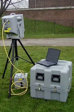
Cyra Technologies was founded in 1993 by Ben Kacyra with the goal of developing a high-precision 3D laser scanner. The company introduced Cyrax, one of the first commercially available laser scanners specifically designed for surveying and engineering applications.
The Cyrax 3D laser scanner helped to address the "as-built documentation problem” in industrial plant retrofits. Traditional measurement methods were slow, prone to errors, and sometimes hazardous. Cyrax offered a faster, safer, and more accurate alternative.
The Cyrax system featured advanced components, including a microchip laser from MIT Lincoln Labs and nanosecond timing electronics from Los Alamos National Lab, with Cyra Technologies securing exclusive licenses for both.
Designed as a portable unit powered by a battery and a laptop, it weighed approximately 88 pounds. The scanner could capture data at 1,200 points per second within a 40° x 40° field of view and had a range of up to 50 meters against a flat white surface. Its success relied on precise time-of-flight measurements, requiring picosecond-level timing to detect laser reflections from nearby objects. These innovations gave Cyra a strong proprietary position in the emerging 3D laser scanning market.
Cyra Technologies faced a major hurdle when existing CAD software couldn’t handle the massive point cloud data from its scanner. With guidance from UC Berkeley’s Carlo Sequin, the company shifted to a computer graphics-based approach and developed its own software, Computer Graphics Perception (CGP), gaining a competitive edge as no similar solution existed at the time.
Chevron Field Testing the Cyrax
Chevron was among the early beta testers. The company used the Cyrax laser scanner in oil and gas fields in Kazakhstan. The purpose of this test was to evaluate how well the Cyrax system could capture detailed spatial data of industrial infrastructure.
The Cyrax scanner produced both camera images and point cloud data of vessels and other equipment in the field. This allowed for precise digital representations of the physical environment. The point cloud data helped Chevron create accurate as-built models of the site, which were essential for planning retrofits, maintenance, and safety assessments.
By using 3D laser scanning instead of manual measurements, Chevron reduced the need for personnel to enter potentially hazardous areas, improving safety, and speeding up data collection.

Leica Geosystems Acquired Cyra Technologies
In 2001, Cyra Technologies was acquired by Leica Geosystems, which rebranded the Cyrax as the HDS 2400. This marked the beginning of widespread adoption of 3D laser scanning in both industrial and civil engineering sectors.
Over the next decade, scanners became more compact, faster, and more accurate, with improved range and data quality. Leica introduced new 3D laser scanners like the HDS 2500 (2002) and HDS 3000 (2004), which increased scanning speed, accuracy, and field of view. By 2009, the Leica P20 could capture 1 million points per second, drastically reducing scan times.
Software platforms like Leica Cyclone and Autodesk ReCap also began to streamline point cloud processing and integration with CAD workflows, making reality capture technology more accessible to engineers, architects, and surveyors.
New Companies and Portable Scanners
Other companies also played major roles in advancing the 3D laser scanning market. FARO Technologies introduced the FARO Focus series, which brought portability and ease of use to the forefront; Trimble entered the market with high-precision scanners tailored for construction and geospatial applications; and RIEGL developed high-performance LiDAR systems known for their speed and accuracy, especially in airborne and mobile mapping.
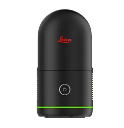
By the 2010s, the introduction of mobile mapping systems like the NavVis VLX and handheld scanners, such as the Leica BLK360 and FARO’s handheld Freestyle, made the technology more accessible and easier to use for a wider range of people and industries.
Released in 2018, the Leica RTC360, is capable of capturing up to 2 million points per second, with a range of up to 130 meters, and features VIS technology for automatic in-field scan registration and HDR imaging for detailed point clouds in under two minutes.
SLAM and the Next Generation of Scanning
The integration of SLAM technology enabled real-time mapping in complex environments such as construction sites and complex facilities.
SLAM (Simultaneous Localization and Mapping) is a method used to create a digital map of a space while simultaneously tracking the scanner’s position within it. In simple terms, localization determines where the scanner is, while mapping builds a layout of the environment. In 3D scanning, SLAM uses a LiDAR sensor to monitor the scanner’s movement and position as it moves through an area. This data allows the software to accurately place and align the scanned information, known as a point cloud, within the digital map.
Recent Advances in 3D Laser Scan Technology
From 2020 to 2025, 3D laser scanning technology has advanced rapidly, driven by innovations in hardware, software, and integration across industries. Scanners have become significantly smaller, faster, and more accurate, with many systems now offering real-time data capture and cloud-based workflows.
According to AVEVA’s March 2025 article “The Future of Reality Capture: What’s Next for Laser Scanning?”, the market size for laser scanning surpassed $3 billion in 2020 and is projected to reach $16.66 billion by 2030.
This growth is fueled by several trends. First, the technology is maturing, becoming more powerful, user-friendly, and affordable. Second, the need to modernize aging infrastructure, industrial plants, and other built environments is becoming increasingly urgent as many facilities face structural wear, outdated systems, and rising safety and efficiency demands.
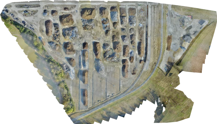
3D laser scanning offers a powerful solution by capturing highly accurate, detailed digital representations of existing buildings and sites quickly and safely. These scans enable engineers and facility managers to create precise “as-built” models, streamline renovation planning, reduce downtime, and improve safety. As industries push toward modernization and sustainability, 3D laser scanning is becoming an essential tool for informed decision-making and long-term resilience.
GPRS 3D Laser Scanning Services
GPRS is a leading 3D laser scanning company in the United States, helping clients to successfully complete their most complex architecture, engineering and construction projects. We've been providing reality capture services and excellent customer service for over 2 decades.
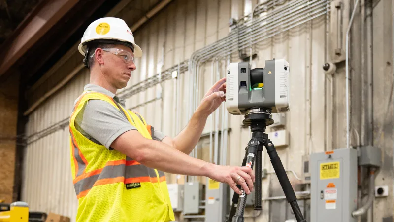
GPRS’ elite team of Project Managers efficiently 3D laser scans the exterior and interior of each site with professional-grade Leica laser scanners, capturing the exact layout, dimensions, and locations of your specific project requirements, such as architectural, structural, and MEP features, walls, windows, doors, stairs, roof, railings, exposed columns, beams, equipment, piping, ducts, and more.
Our Mapping & Modeling Team registers and processes the point cloud, removing noise and setting the coordinate system to provide the most precise measurements. Data is then compiled into custom 2D CAD drawings and 3D BIM models and delivered via SiteMap®. SiteMap® is GPRS’ secure GIS platform that delivers point cloud data, 2D CAD drawings and 3D BIM models, giving clients 24/7 access to verified as-built documentation to help them plan, build, and manage better.
What can we help you visualize?
Frequently Asked Questions
How has 3D laser scanning evolved in construction?
In the 1960s, 3D laser scanning technology was in its infancy and primarily used for experimental purposes to explore how lasers could be applied to capture the profile of surfaces. These early systems used lights, projectors, and cameras to scan objects, but they were extremely slow and produced low accuracy results due to the limitations of the technology. Laser technology saw significant growth in the 1980s, particularly in military and scientific research. By the 1990s, LiDAR (Light Detection and Ranging) and ground-based laser scanners became more available and began to integrate with CAD software for design, engineering, and the creation of 2D and 3D models. The first commercial scanners emerged in the early 1990s, improving accuracy and adoption in various industries, such as construction and manufacturing.
Why is 3D laser scanning important in modern construction?
It provides highly accurate, real-world data for design, renovation, and facility management, reducing errors, saving time, and improving coordination across trades through tools like BIM (Building Information Modeling).
What are the benefits of 3D laser scanning?
- Fast, Accurate Data Collection: A single laser scan captures millions of 3D data points per second, providing incredibly rich detail of a building or project site. Datasets are dimensionally accurate, measurable and shareable, expediting project planning and execution.
- Eliminates Revisits and Disruption: Sites are captured in high detail the first time, eliminating the need for return visits. High speed data collection expedites projects that require minimal disruption.
- Reduces Costs and Change Orders: Accurate design plans are produced from the start expediting field work and reducing change orders, delays and costs.
- Safe and Non-Contact: 3D laser scanners collect data on tripods from a distance in hard-to-reach or hazardous locations, keeping workers out of harm’s way. The non-intrusive nature keeps historic sites and artifacts untouched.
- Improves Communication: Communication is improved, teams can discuss plans while each has access to the same information, creating a more dynamic working environment.