

.svg)
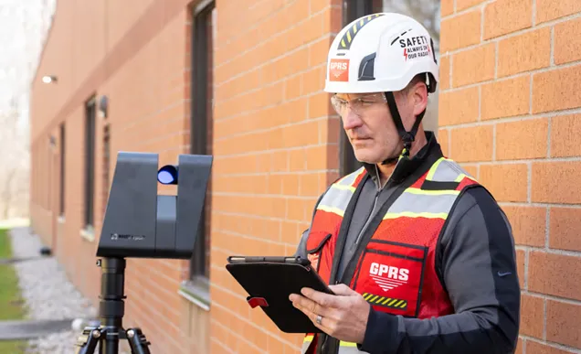
If you’re considering reality capture services for your next project, you’ll encounter the terms LiDAR and 3D Photogrammetry. They are technologies that are best utilized when operated by reality capture professionals, like GPRS Project Managers.
While they both have similar uses and can sometimes complement each other, their capabilities and ideal scopes of work are different.
By understanding these differences, you can make a well-informed decision on how to best capture your reality.
WHAT IS LiDAR?
LiDAR, short for “light detection and ranging,” is a remote sensing technology that uses light in the form of a pulsed laser to measure distances to a target. A LiDAR sensor sends out beams of ultraviolet and/or near-infrared light and then measures how long it takes for them to return to the sensor. Each scan is limited to the scanner’s line-of-sight, so multiple scans are required to provide a comprehensive 3D view of an object or scan area.
GPRS utilizes LiDAR technology in our reality capture services to provide clients with highly accurate scan data that we can translate into 2D CAD drawings and 3D models. LiDAR can also be used with other technologies like ground penetrating radar (GPR) or electromagnetic (EM) locators in an attempt to “Go Beyond the Line of Sight.”
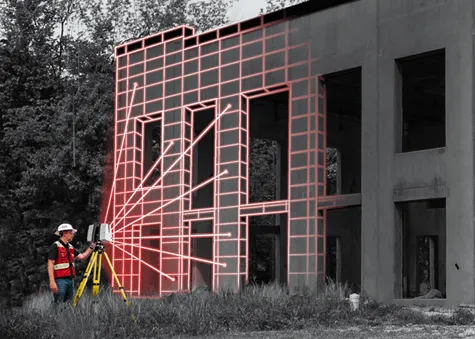
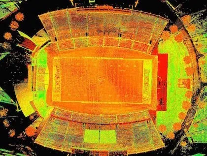
Once a given geographical area, terrain, building, or space is scanned using a LiDAR laser scanner, a point cloud of the area is created.
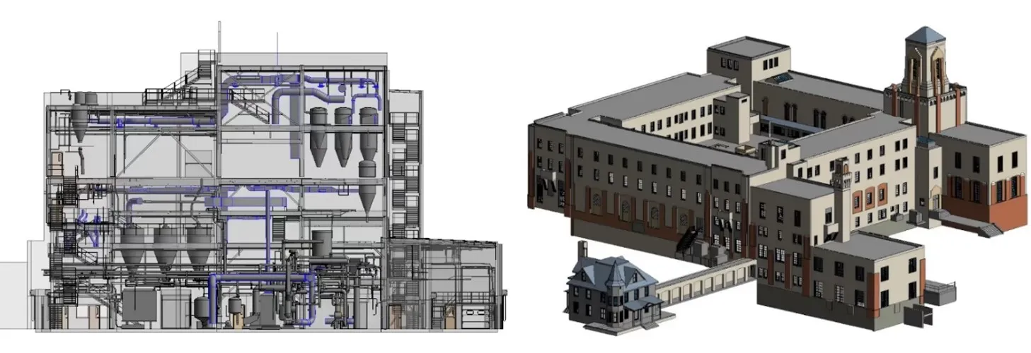
Point clouds provide powerful and dynamic information for a project. CAD technicians, like the GPRS Mapping & Modeling Team, transform point clouds into deliverables vital for decision-making and analysis, such as 2D CAD drawings and 3D BIM models.

Site plans, floor plans, elevations, isometric drawings, and reflected ceiling plans are all examples of 2D drawings that GPRS can provide using reality capture technology like LiDAR.
GPRS also provides 3D modeling and scan-to-BIM services to support design, visualization, space definition, prefabrication, and clash detection.
There are two types of LiDAR scanners: airborne and terrestrial. Airborne LiDAR scanners mount a laser to a remote-control device, like a drone, to capture scan data. Terrestrial LiDAR scanners are typically mounted to a tripod and are stationary during the scanning process. Terrestrial LiDAR scanners are the type most commonly utilized by GPRS Project Managers.
In recent years, Apple has added LiDAR sensors to the latest iPhones for better camera quality and augmented reality (AR) experiences.
LiDAR services and deliverables are ideal for construction and architectural projects. Accurate point cloud data from LiDAR 3D scans helps professionals in AEC industries keep projects on schedule, within budget, and safe.
There are many manufacturers that utilize LiDAR scanning technology, including:
- Leica Geosystems – the most well-known manufacturer of LiDAR scanning technology. They are known for their high accuracy and user-friendly integration with CAD & BIM platforms
- FARO Technologies – known for applications in AEC industries along with forensic cases and assembly lines
- Luminar Technologies – the only company with LiDAR technology included in the global production of a vehicle
- YellowScan – known for drone LiDAR scanning in the entertainment, archeological, and agricultural industries.
- Teledyne Optech – known for their advanced aircraft LiDAR scanning and surveying
WHAT IS PHOTOGRAMMETRY?
Photogrammetry is the process of capturing images and stitching them together to create a digital model of a structure or site for visualization, planning, and analysis.
Photogrammetry uses a camera, which can also be equipped with LiDAR, to digitally document sites with high-resolution photographs. The photographs are taken from different positions and angles to capture a 360° view of each setup and can be stitched together in a virtual tour of the site.

Like LiDAR, there are two types of photogrammetry: aerial and terrestrial. Aerial photogrammetry captures aerial photos by mounting a camera to a drone or an aircraft, while terrestrial photogrammetry takes photos from a fixed position.
The data captured with photogrammetry can be used to create digital twins, virtual tours, floorplans, 2D CAD plan views, digital terrain models, and more.
GPRS utilizes 3D Photogrammetry as part of our reality capture services, and our WalkThru 3D, FLRPLN, and ProCap products. It has tremendous value in its ability to capture our 99.8% accurate field markings to allow our Mapping & Modeling Team to create integrated digital twins and provide a 360° view of any site or facility.
There are many manufacturers that utilize 3D photogrammetry technology, including:
- Matterport – utilizes LiDAR to create interactive 3D models, point clouds, layouts, and floorplans of physical spaces best suited for real estate and facilities
- Pix4D – performs aerial and terrestrial photogrammetry that also utilize LiDAR for AEC industries, land surveying, and forensic cases
- Polycam – created an app that allows smartphones to perform 3D photogrammetric scans
It is also important to note that most brands that utilize photogrammetry also utilize LiDAR technology, and vice versa.
WHAT ARE THE SIMILARITIES AND DIFFERENCES BETWEEN LiDAR AND PHOTOGRAMMETRY?
One of the biggest differences between LiDAR and photogrammetry is the level of accuracy of the scans.
LiDAR laser scanners can capture 2-4 mm accurate scans up to 60 meters away. They achieve this by capturing 2 million data points per second. This level of high accuracy is why it is most ideal for architecture and construction. Being off by an inch or two can make a huge difference on a job site. Photogrammetry is done with overlapping, rectified photos that focuses more on detailed images rather than accurate measurements.
However, if color images are what a client needs, then photogrammetry is the route to go. By default, all photogrammetry scans are in full color while LiDAR scans are in greyscale. LiDAR can do color scans if chosen ahead of time. That choice does extend the time needed to conduct the 3D scans, so it’s important to address that early on. LiDAR laser scanners rely on the overlap of a laser point cloud and a 3D photo in order to assign an RGB value to the point cloud.
Photogrammetry scans are also full of rich visual detail. The texture and color of surfaces are very well captured through photogrammetry scans. LiDAR scans are often limited in the amount of surface detail conveyed in the scans.
One benefit of LiDAR’s default greyscale scans is its ability to scan data in darker or even pitch-black environments. That is beneficial for jobs in places with limited lighting like underground caves. Since photogrammetry scanners only shoot in color, it will not pick up any good scan data in darker environments without extra lighting.
In terms of similarities, LiDAR and photogrammetry scanners can both create similar deliverables as well. While the process of creating them may be different, they can both create 3D models, points clouds, and 2D drawings.
LiDAR and photogrammetry also can both be conducted in the air on drones or aircrafts, and on the ground from a stationary position.
They both support planning, design, construction, and facility management by reducing site visits, improving collaboration, and streamlining workflows.
Another similarity between LiDAR and photogrammetry products is that it is always best to hire professionals, like GPRS Reality Capture Project Managers, to use these tools and capture scan data. Even if you have thousands of dollars to spend on a brand-new laser scanner, the result will lack accuracy without the proper training and expertise of a professional.
CAN THEY BE USED TOGETHER?
LiDAR and 3D Photogrammetry can be used together on some occasions to amplify scan results. Since they each have certain weaknesses that the other does not, their technologies can be complementary.
For example, since LiDAR scans are conducted in greyscale, photogrammetric imagery can be used to enhance and colorize point cloud data.
Further, 2-4 mm accurate LiDAR scans can be used to create an accurate model backbone that ties in 3D photogrammetry scans to make the model more precise.
HOW DO I KNOW WHEN I NEED REALITY CAPTURE SERVICES?
Almost any project that requires as-built information can benefit from a laser scanning survey.
Utilizing GPRS’ reality capture and 3D laser scanning services can yield the following benefits:
- Collecting millions of real-world data points
- Eliminate measurement errors
- Reduce change orders and waste
- Eliminating or minimizing operational shutdowns and client inconvenience
- Increased safety

For LiDAR and photogrammetry, their capabilities and ideal scope of work perfectly demonstrate how they can help you.
We recommend a GPRS Project Manager utilizing LiDAR laser scanners if you need:
- A detailed scan of a building’s entire exterior and/or interior
- To update a structure’s as-built documentation
- 2D CAD drawings or 3D models with high accuracy
- A 3D model of complex mechanical, electrical, and plumbing (MEP) systems
- Updated measurements and models of historical buildings without having to physically touch the aging infrastructure
We recommend a GPRS Project Manager utilizing 3D Photogrammetry if you need:
- To create a virtual tour of a real estate, commercial, or industrial space
- To create a digital twin to track progress or plan future projects
- To develop floorplans, 3D models and walkthroughs
- Color models of a structure or facility
- Highly detailed images of building façades not easily seen from the ground
From schools to stadiums, to skyscrapers, GPRS captures your reality to keep your projects on time, on budget, and safe.
What can we help you visualize?
FREQUENTLY ASKED QUESTIONS
What is Scan-To-BIM?
Scan to BIM is the process of digitally capturing a site with a 3D laser scanner and using the data to create a BIM model. Building information modeling (BIM) is an intelligent software modeling process that engineers, contractors, and architects can use to collaborate on a building’s design, construction, and operation. It’s more than just a model. It’s a process of collecting and managing data throughout a building’s entire life cycle.
What Is a Digital Twin?
A digital twin is a highly complex virtual model that is the exact counterpart (or twin) of a physical object. GPRS uses 3D laser scanners to collect real-time data for a building or facility and create a digital duplicate. Data can be easily visualized, measured, analyzed, and updated. Digital twins can be used to improve efficiencies, optimize workflows and detect problems before they occur.