

.svg)
Environmental Due Diligence: Phase I & Phase II ESA Guide
What is Environmental Due Diligence?
Environmental due diligence evaluates a property’s environmental conditions and risks. Buyers, lenders, developers, and attorneys request on site reviews to understand potential liabilities, like contamination or hazardous materials, before they purchase, occupy, refinance, or use a property as loan collateral.
When is Environmental Due Diligence Required?
Environmental due diligence is often required before a real estate transaction and is also used for refinancing or construction loans. Commercial lenders and real estate professionals receive a full risk report on a property to understand its potential benefits, downsides, and environmental concerns that may affect value or liability.
What is the Purpose and Process of Environmental Due Diligence?
Environmental due diligence is a key part of any commercial real estate deal because it helps buyers and lenders understand whether a property has any environmental issues that could impact health, safety, or value.
The process typically starts with a Phase I Environmental Site Assessment (ESA), which reviews the site’s history and current conditions to identify any potential problems. If the Phase I ESA raises concerns, a Phase II ESA may follow, involving soil, groundwater, or air sampling to confirm whether contamination is present.
What is a Phase I Environmental Site Assessment?
A Phase I Environmental Site Assessment or Phase I ESA is completed to research the current and historical uses of a property as part of a commercial real estate transaction.
The intent of the assessment is to identify if current or historical property uses have impacted the soil or groundwater beneath the property and could pose a threat to the environment and human health. If these issues are found, it presents potential liability for the lender and owner and can affect the value of the property.
It includes a visual site inspection, a review of historical records and regulatory databases, and interviews with owners to identify Recognized Environmental Conditions (RECs). These tasks are performed to the ASTM E1527‑21 industry standard and do not involve sampling, testing, or any physical on‑site investigation.
What are Recognized Environmental Conditions (RECs)?
A REC is the presence or likely presence of hazardous substances or petroleum products due to a release, conditions indicative of a release, or a material threat of a future release. Examples include leaking underground storage tanks, historical solvent releases (e.g., PCE/TCE), or chemical spills affecting soil, groundwater, or structures.
What is the ASTM E1527-21?
ASTM E1527-21 is the current industry standard for conducting a Phase I ESA. It defines the scope, methods, and reporting needed to identify RECs and to support compliance with federal All Appropriate Inquiries requirements.
What is a Phase II Environmental Site Assessment?
A Phase II Environmental Site Assessment (ESA) or Phase II ESA is an intrusive investigation performed when a Phase I ESA indicates potential contamination. It confirms the presence, type, and extent of hazardous substances or petroleum products through field sampling (e.g., soil, groundwater, and sometimes soil gas/indoor air), laboratory analysis, and data interpretation. The results provide decision ready evidence of environmental conditions and potential liabilities to inform property transactions, redevelopment, and risk management.
What are the Key Components of a Phase II ESA?
- Soil Sampling – Borings at multiple depths to evaluate contamination.
- Groundwater Sampling – Monitoring wells to assess groundwater quality.
- Surface Water/Sediment Testing – If applicable, testing nearby bodies of water.
- Soil Vapor Assessment – Evaluates VOCs and potential indoor air risks.
- Laboratory Analysis – Certified lab testing for metals, petroleum hydrocarbons, VOCs, SVOCs, and other contaminants.
The results from these tests help determine whether contamination is present at levels exceeding regulatory thresholds and if remediation or further action is necessary.
Phase II Environmental Site Assessments
Quick Guide to Soil and Groundwater Sampling
Groundwater and soil sampling are collected using drilling rigs, augers, or direct‑push probes. Soil is cored at specific depths to see what’s happening beneath the surface, while groundwater is collected through monitoring wells or direct‑push tools. These methods are designed to keep samples clean and accurate so they truly represent site conditions.
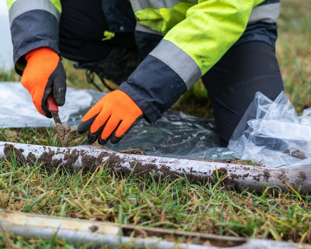
What Are Soil Borings?
Soil boring is a geotechnical investigation technique used to collect soil samples from below the ground surface. These samples are analyzed to determine the physical and mechanical properties of the soil, such as composition, density, moisture content, strength, and bearing capacity. The information gathered is crucial for designing safe and effective foundations for buildings, roads, bridges, and other infrastructure. Soil borings are also used in environmental assessments to detect contamination, monitor groundwater, and evaluate the suitability of land for agricultural or industrial use.
What is Groundwater Sampling?
Groundwater sampling is the process of collecting water from below the ground, usually through monitoring wells or direct push probes, to test for contaminants and assess the quality, chemistry, or environmental impact of groundwater at a site. It provides reliable, representative data about what’s happening beneath the surface, helping environmental professionals evaluate contamination, track pollutant movement, and make informed decisions about cleanup, redevelopment, or regulatory compliance.
How Can GPRS Support Soil and Groundwater Sampling?
Identifying safe boring locations is difficult when underground utilities are unknown or poorly mapped. Drilling without clearance can cause strikes, injuries, delays, and added costs. GPRS provides accurate maps of public and private utilities using utility locating and video pipe inspection. We clear drilling locations in advance to protect your team and infrastructure. Reliable utility data reduces risk, supports efficient sampling, and helps your team maintain safety while in the field. Contact GPRS today to support your soil and groundwater sampling efforts.
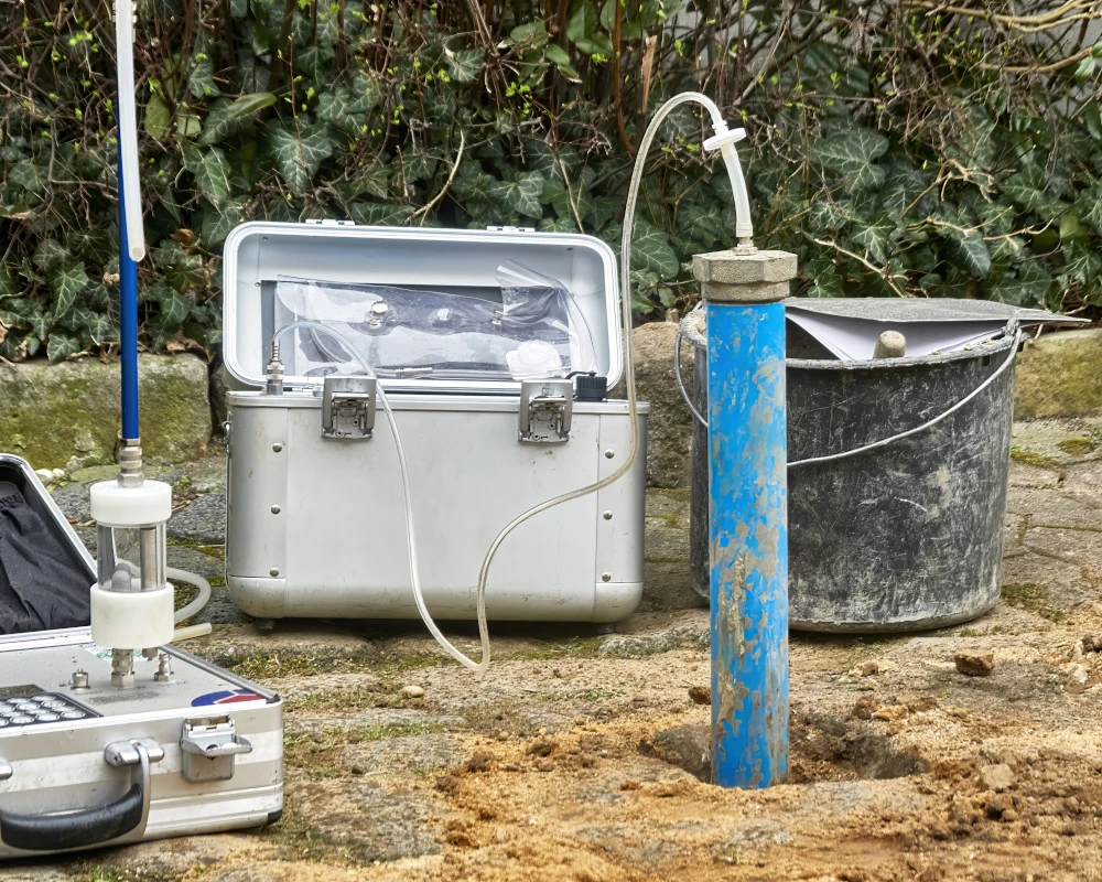
Quick Guide to Soil Vapor Assessment
Contaminants like petroleum and solvents can migrate as vapor and infiltrate buildings. A soil vapor assessment measures volatile organic compounds (VOCs) in the spaces between soil particles. It identifies if toxic vapors from contaminated soil or groundwater are moving into buildings, posing health risks to occupants. This assessment determines the need for mitigation, such as vapor barriers or venting systems.
What are Volatile Organic Compounds (VOCs)?
Volatile organic compounds (VOCs) are carbon-based chemicals that evaporate easily. They can be found in common household products, such as paints, cleaners, adhesives, and industrial processes. These compounds can impact indoor air quality and health, especially in enclosed spaces.
What are Semi-Volatile Organic Compounds (VOCs)?
Semi-volatile organic compounds (SVOCs) are a group of human-made chemicals that easily transition between solid/liquid and gas phases at ordinary temperatures. Common in indoor environments, they include plasticizers, flame retardants, and pesticides found in furniture, electronics, and building materials, often contained in dust and on surfaces.
What is Vapor Intrusion?
Vapor intrusion (VI) occurs when volatile chemicals migrate from contaminated soil or groundwater into buildings. It can expose occupants to hazardous compounds and complicate transactions and redevelopment if not addressed.
How Can GPRS Support Soil Vapor Assessment?
Installing vapor pins requires drilling through slabs, risking conduit strikes and damaging reinforcements, especially in buildings with little to no documentation. GPRS SIM-certified Project Managers use concrete scanning and utility locating to identify shallow utilities and reinforcement before drilling. We support vapor intrusion investigations with subsurface data, mapping, and modeling. You get accurate data that reduces disruption, prevents strikes, and supports compliance with health and safety regulations. Contact GPRS today to support your soil vapor assessment efforts.
Quick Guide UST & LUST Investigations
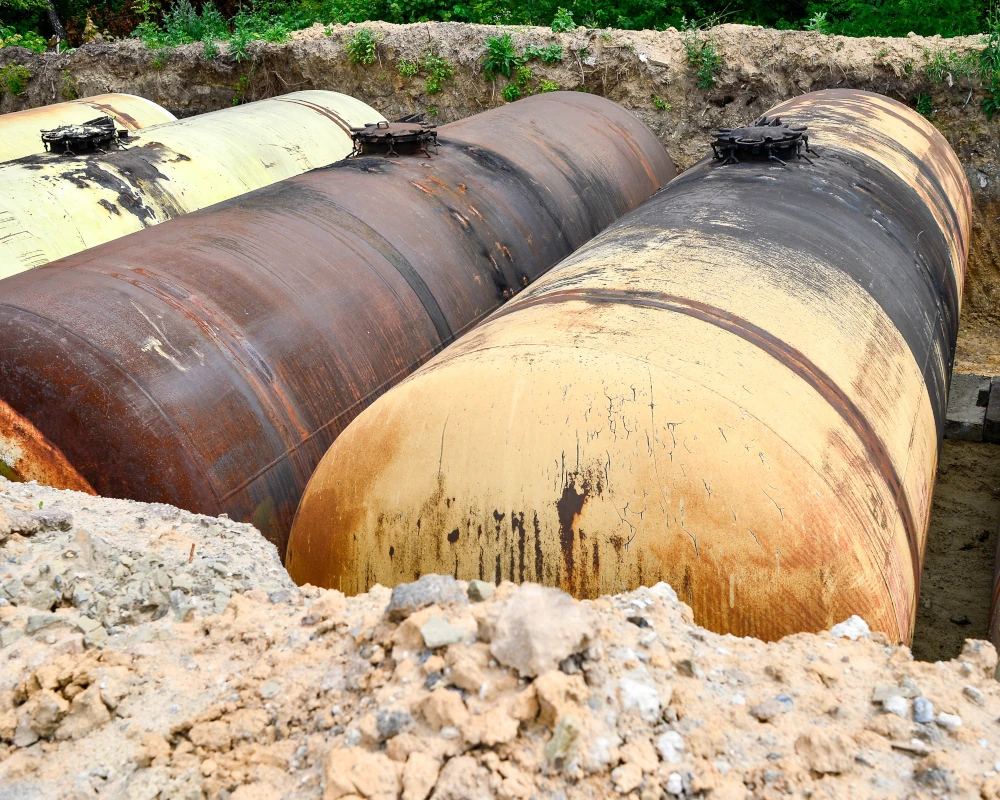
What are Underground Storage Tanks (USTs)?
USTs are tanks and associated piping buried underground to store petroleum or other hazardous substances. They are commonly found at gas stations, airports, truck fleet refueling facilities, automotive service stations, dry cleaners, and industrial facilities. USTs must be designed, installed, and maintained to prevent leaks and ensure environmental safety.
What are Leaking Underground Storage Tanks (LUSTs)?
LUSTs occur when underground tanks develop cracks, rust, or fail due to mechanical or structural issues. These leaks can release hazardous substances into the surrounding soil and groundwater, leading to significant environmental contamination.
Read more about USTs and LUSTs.
What is the Cause of Leaking Underground Storage Tanks (LUSTs)?
- Corrosion: Older steel tanks are prone to rust, leading to leaks.
- Structural Failure: Pressure changes and environmental stressors can cause tank deterioration.
- Improper Installation: Poor installation techniques may contribute to early failure.
- Accidental Damage: Construction and excavation activities can rupture tanks or piping.
- Neglected Maintenance: Lack of routine inspection and repair increases the risk of leaks.
How Can GPRS Support UST Investigations & LUST Locating and Mapping?
GPRS uses utility locating to safely locate orphaned, abandoned, or active UST systems. We provide CADD maps and conceptual site models (CSMs)to support remediation and compliance. Fast, accurate data helps you reduce risk, protect property value, and make informed decisions during due diligence. Contact GPRS today to support your UST & LUST investigations with locating and mapping.
What is a Conceptual Site Model (CSM)?
A conceptual site model or CSM is a 3D rendering of the subsurface data at the site that allows visualization of preferential pathways for delineation of liquids.
Case Study: Gas Stations May Be Leaking Underground
Quick Guide to Delineation and Remediation
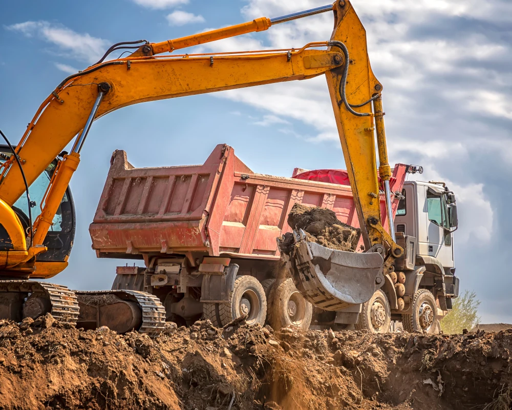
What is Delineation and Remediation?
Delineation defines the extent of soil or groundwater contamination, ensuring it is mapped accurately. It includes taking soil samples, installing groundwater monitoring wells, and using analytical chemistry to find where contamination exceeds legal thresholds.
Remediation is the cleanup, removal, or containment of those contaminants to protect human health and the environment. This can include treating the contamination on-site, such as injecting chemical agents into the ground or removing the contaminated material and treating it off-site.
How Can GPRS Support Delineation and Remediation?
Tracking contamination across soil, groundwater, or soil vapor can be complex. GPRS provides scalable solutions from utility locating, concrete scanning, video pipe inspection as well as 3D laser scanning, CAD mapping, and BIM modeling to meet the needs of your project. Precise data and efficient workflows help you save time, reduce costs, and make confident decisions that support reaching No Further Action (NFA) or regulatory closure. Contact GPRS today to support your delineation and remediation efforts.
What is No Further Action (NFA) or Regulatory Closure?
A No Further Action (NFA) letter, or regulatory closure, is a formal document issued by an environmental agency (e.g., EPA, state DEQ) confirming that a contaminated site has been sufficiently investigated and remediated to meet safety standards. It signifies that no additional cleanup is required, allowing for property closure, financing, or redevelopment.
GPRS Utility Locating, Mapping, and Modeling Services
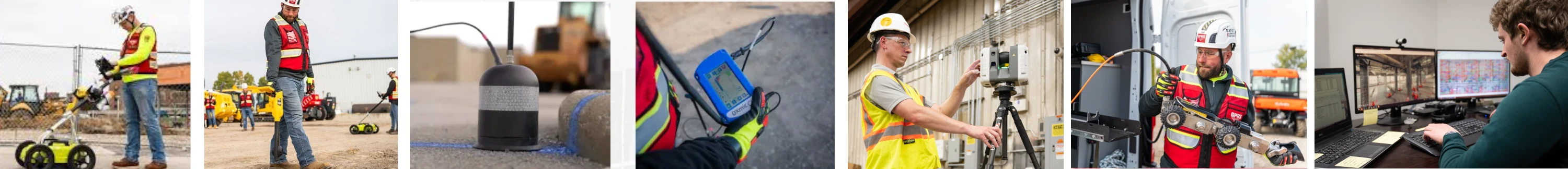
If you’re managing environmental concerns, or planning soil borings, vapor pin installations, or UST investigations, accurate subsurface data is essential for safety and cost control.
GPRS utility locating identifies underground utilities and UST components, helping you clear soil borings, install vapor pins, drill safely, and avoid damage.
We provide a full suite of services, including utility locating, concrete scanning, video pipe inspection, and 3D laser scanning, tailored to your project needs to support safe sampling, hazard identification, and remediation planning.
Our custom utility CADD maps protect infrastructure, while Conceptual Site Models (CSMs) reveal potential contaminant migration pathways and guide your next steps.
Deliverables are uploaded to GPRS’ SiteMap® GIS platform, giving you fast access to accurate data and insights to help you reduce risk, stay compliant, and make confident decisions.
As a trusted leader in damage prevention within the environmental sector, GPRS provides dependable results from the initial investigation through delineation, remediation, and project completion. With a nationwide network of Project Managers, we are prepared to mobilize quickly for projects across the United States.
How can we support your environmental due diligence and Phase II ESAs?