

.svg)
Facilities managers are all too familiar with the challenges of wastewater systems management. Fortunately, there is a new tool that could take a lot of the stress out of maintaining sanitary and storm sewer lines by allowing you to visualize your subsurface infrastructure from anywhere 24/7. That may sound like science fiction, but it’s now reality thanks to GPRS’ new SiteMap® Sewer Layer.
Accurately locating and managing underground sewer infrastructure traditionally requires a lot of guesswork around incomplete, outdated sanitary or storm sewer as-builts, and expensive, time-consuming, and wasteful potholing as you play a frustrating game of whack-a-mole trying to find the source of a break, blockage, or overflow.
And the worst part is that after all that, you still don’t know the exact location of all your sewer lines, cleanouts, and laterals, let alone any damaging cross bores caused by trenchless technology line installations drilling straight through your sewer system.
That’s why GPRS is pleased to introduce you to the SiteMap Sewer Layer, a transformative solution for facilities and municipal managers. delivering precise, accessible, and actionable sewer mapping data. This innovation enhances everything from daily operational efficiency to risk mitigation, and long-term asset maintenance planning by providing a centralized, single source of truth for sewer systems.

What is the SiteMap Sewer Layer?
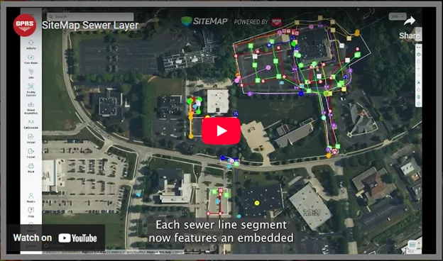
The SiteMap Sewer Layer integrates data collected through GPRS’ advanced video pipe inspection technologies, including CCTV robotic crawler cameras and lateral launch “push camera” systems. These tools, used in concert with utility locating technologies like ground penetrating radar (GPR), electromagnetic (EM) locators, tracer wires, and sondes, capture high-resolution imagery and video, enabling detailed condition assessments and precise mapping of sewer lines, lateral connections, and manholes. The resulting data is uploaded to the SiteMap® platform (patent pending), where you can view, analyze, and share it with key team members, subcontractors, and stakeholders in real time.
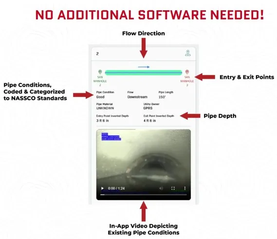
There is no additional software required to see each geolocated pipe segment, the entry & exit points for that segment, pipe material, depth, flow direction, and the condition of the segment, coded and categorized to NASSCO standards. Plus, in-app video depicting your existing pipe conditions, allowing you to proactively plan, maintain, repair and upgrade your sanitary and storm systems to:
• Reduce potholing & destructive excavation
• Reduce utility strikes & service interruptions
• Find damaging cross bores before they compromise your system
Regardless of industry, this new tool is a game-changer. As GPRS Chief Strategy Officer, Jason Schaff said in a recent press release on the subject, “Two of the biggest problems we’ve been trying to tackle for our customers, especially those managing large campuses or municipalities, are how we can give them concrete evidence showing them exactly where in the world their sewer lines are, and what condition they are in, so that they have access to that data in the palm of their hand 24/7.”
“We believe SiteMap’s Sewer Layer update solves both issues; not only can you see direct video of every pipe segment and its condition, each line is geolocated with real-time kinematic positioning (RTK), so you can be certain of the location of every pipe in your wastewater infrastructure. And since it’s all delivered via SiteMap, you have complete access and control of your wastewater system data from anywhere, anytime you need it, to plan upgrades, expansions, and repairs.”
How Does The SiteMap Sewer Layer Help Facilities Managers?
Facilities managers in higher education, health care, manufacturing, municipal wastewater, and virtually every industry could shift to proactive vs. reactive maintenance and repair schedules, provide concrete sewer budget items for capital planning, avoid service interruptions, locate previously unknown sanitary and storm sewer lines, and eliminate construction delays.
University campuses often span hundreds of acres with sewer infrastructure that spans centuries. With SiteMap, operations and facilities managers can identify root intrusions, pipe deformation, or blockages before they escalate into costly emergencies. For example, The University of Toledo now has its entire sanitary and storm sewers, water lines, steam lines, and more, mapped and catalogued in SiteMap for their use.
In manufacturing environments, unplanned downtime due to sewer failures can halt production and compromise safety. SiteMap allows plant engineers to monitor critical sewer lines beneath production floors, loading docks, and chemical storage areas. A Midwest automotive manufacturer leveraged SiteMap to provide a full site scan of its facilities, covering 3,700,000 s.f. and 419 acres while it retooled and renovated.
“One of the biggest issues we were solving [for the auto plant] was scanning and collecting the data proactively ahead of the project rather than waiting until the construction phase. This gave them the subsurface information they needed to design and plan with accurate information that we updated from the out of date and inaccurate as builts.” – Nate Stair, GPRS SiteMap Market Segment Leader & Account Executive
Municipal wastewater departments benefit from SiteMap’s ability to centralize data across multiple sites and teams. With aging infrastructure and limited budgets, municipalities must prioritize repairs based on accurate condition assessments. The City of Fremont, California utilized GPRS’ video pipe inspection & SiteMap to accurately locate and track the remediation of 10 dangerous cross bores caused by directional drilling fiber line installations. The platform’s cloud-based access enabled collaboration between public works, engineering consultants, and contractors, streamlining their repairs.
Municipalities across the U.S. are requiring pre and post-cross bore inspections surrounding fiber line installations to avoid dangerous and costly sewer problems caused by utility line intrusions.
Health care facilities, where sanitation and operational continuity are paramount, gain critical visibility of data with SiteMap.
Hospitals and medical campuses often have complex, undocumented sewer networks. General contractor Rudolph Libbe used SiteMap® to trace sewer lines that were more than 150 years old, and verify the locations of all their subsurface infrastructure prior to building a new central utility plant at Mercy Health’s St. Vincent Medical Center. With precise mapping and video documentation, the facilities team coordinated to locate the CUP much closer to the main hospital than usual. This was only possible with exceptional subsurface as-builts.
What Are The Benefits of SiteMap's Sewer Layer?
Key benefits of the SiteMap Sewer Layer include the ability to:
• Navigate to any individual line, lateral, or feature in your storm or sanitary sewer system
• Access the geolocated, tagged, and annotated video feed of your pipe conditions anytime, anywhere at the touch of a button
• Filter your data based on pipe condition and level of defect
• Securely share any segment of your sewer data with your team, contractors, vendors, and subcontractors to eliminate confusion & miscommunication
• Maintain a permanent record of your sewer data for future planning and proactive maintenance
The bottom line: GPRS’ new SiteMap Sewer Layer gives facilities managers a powerful tool for reducing risk, optimizing maintenance, and extending the life of critical wastewater infrastructure.
What can we help you visualize? Schedule your personal SiteMap demonstration and view information about the new Sewer Layer, here.