.svg)
Gas Stations May Be Leaking Underground
Soil and groundwater contamination due to leaking underground storage tanks (LUSTs) is currently one of the major environmental problems in the world.
Every gas station has the potential to leak and contaminate the surrounding community. Underground storage tanks and pipes can corrode, shift, or settle over time, causing tanks and pipes to crack, break, and leak. The result is disastrous, as petroleum can seep through the cracks and contaminate surrounding soil, ground water, surface water, or affect indoor air spaces.
A slow leak from a typical 10,000-gallon gasoline storage tank at the neighborhood service station would be virtually undetectable to the station operator, but very hazardous to nearby groundwater supplies. According to the International Journal of Environmental Research and Public Health, a 10-gallon gasoline leak can contaminate about 12 million gallons of water. A leak must be reported to environmental agencies in 24 hours and the process of investigation and remediation must begin immediately.
Collecting as built data of a gas station’s infrastructure can be difficult to source and expensive in an emergency situation. It is imperative that stakeholders have accurate site data to visualize migration routes, communicate with the emergency team, make informed remediation decisions, and protect the workers on site and the environment.
GPRS conducted utility locating and 3D laser scanning services at a Michigan gas station to document the existing conditions for site upgrades and to develop an emergency response plan for potential leaks.
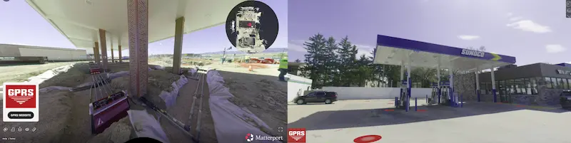
Reality Capture technologies were also used to create immersive digital twins of the site. This lets stakeholders explore the property virtually. They can examine the layout, asset conditions, and take rough measurements without being there in person.
GPRS Utility Locate and 3D Laser Scan for a Gas Station
Location: Brighton, Michigan
Task:
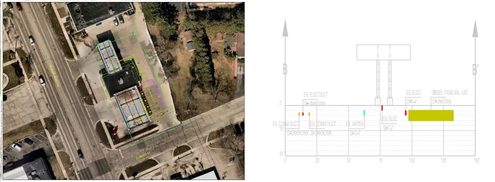
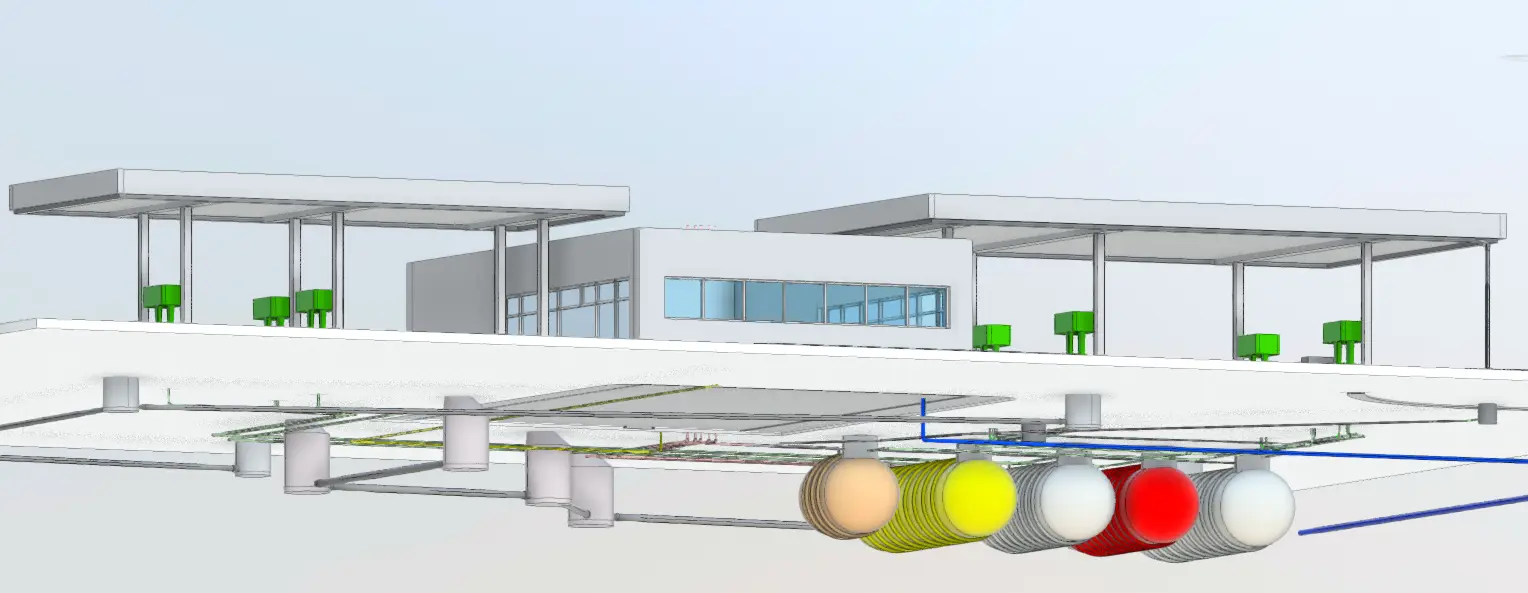
A Michigan gas station requested utility locate and as built data to document the existing conditions for site upgrades and to develop an emergency response plan for potential leaks. Accurate 2D utility locate maps, a 3D BIM model, and a conceptual site model (CSM) were created of the gas station, underground storage tank system, and surrounding utilities.
Problem:
- The gas station lacked as built site information required for compliance with environmental regulations, essential to plan for site upgrades, and necessary to take prompt corrective action in the case of an emergency.
- The client did not have an accurate conceptual site model (CSM) to understand and interpret contaminant fate and transport in the subsurface.
- The UST system installer had limited visibility into the layout and installation of critical infrastructure. This includes tanks, pumps, and piping systems.
Solution:
- GPRS Project Managers used state-of-the art equipment to perform ground penetrating radar (GPR), electromagnetic (EM) locating, video pipe inspection (VPI), leak detection, 3D laser scanning, and drone photogrammetry services at the gas station.
- The GPRS Mapping & Modeling Team delivered accurate as built and utility location data in point cloud, 2D maps, 3D BIM model, and CSM formats, to help eliminate guesswork from decision making, and prevent time-consuming and dangerous mistakes and the costs associated with them.
- The use of reality capture allowed for high-resolution 3D walkthroughs of the site, which were shared with contractors and property owners to visualize above-ground assets to plan future rebranding and remodeling efforts.
- The gas station received access to millimeter-accurate information to efficiently plan work and drill safely.
- Detailed site maps can help to communicate the location of a leak, the most likely paths and extent of horizontal and vertical delineation, and to plan assessment and mitigation efforts.
Benefits:
- Infrastructure location and mapping are vital before conducting any construction or subsurface work like soil boring, or coring concrete to drop vapor pins – to eliminate clashes and utility strikes and keep workers and the community safe.
- GPRS as-built maps and models provide accurate information to avoid hitting a UST or system component, and to avoid a utility strike when sampling soil.
- The GPRS SiteMap® mobile app securely stores utility data, geolocated and layered, and securely accessible for the station stakeholders to share with those who may need it.
- The data GPRS collects can also be used to develop the utility portion of a conceptual site model (CSM) to visualize migration routes, communicate with stakeholders, make informed remediation decisions, and protect the team on site and the environment.
- Reality Capture helps bridge the gap between contractors and property owners. When field changes occur, scans provide a visual record of the “as-built” conditions. This reduces reliance on hand-marked maps and undocumented changes.
- Reality Capture data can be integrated into SiteMap. This provides visual context with utility data. It helps improve decision-making for upgrades, rebrands, and future planning.
With Project Managers in every major market and city across the United States, GPRS has an unmatched nationwide service network that makes it quick and easy to find an expert Project Manager in your area. Having access to accurate facility information is crucial for project upgrades and emergency response. GPRS can quickly deliver utility locate and as built data of your next project to Visualize Your Built World®. Contact us today.