

.svg)
What Is BIM Building Information Modeling?
Building Information Modeling (BIM) is the process of creating an intelligent, digital 3D model that represents the physical and functional characteristics of a building and its infrastructure. It integrates geometry, spatial relationships, geographic data, quantities, and component properties into a unified model, enabling architects, engineers, and contractors to collaborate more effectively throughout design, construction, and maintenance.
BIM is not just a 3D model. According to Autodesk, “Building Information Modelling (BIM) is the holistic process of creating and managing information for a built asset. Based on an intelligent model and enabled by a cloud platform, BIM integrates structured, multi-disciplinary data to produce a digital representation of an asset across its lifecycle, from planning and design to construction and operations.”
What Building Life Cycle Processes Does BIM Support?
The process of BIM supports the creation of intelligent data that teams can use throughout the lifecycle of a building or infrastructure project.
Plan: BIM helps with early project planning. It uses reality capture technology to gather real-world data. This data creates accurate models of current conditions. This foundational information helps teams make informed decisions before design planning.
Design: In the design phase, teams use BIM to reference as-built documentation, develop conceptual layouts, and perform analysis. BIM data also supports preconstruction planning, helping to align schedules and logistics early in the process.
Construction: As construction begins, BIM specifications guide fabrication and on-site assembly. Contractors and trades use the model to coordinate tasks. It helps streamline workflows and ensures construction activities are done efficiently and on time.
Operations: After the project ends, BIM data moves to the operations phase. It helps with maintenance, asset tracking, and facility management. It also provides a valuable resource for future renovations.
What are the Elements of BIM?
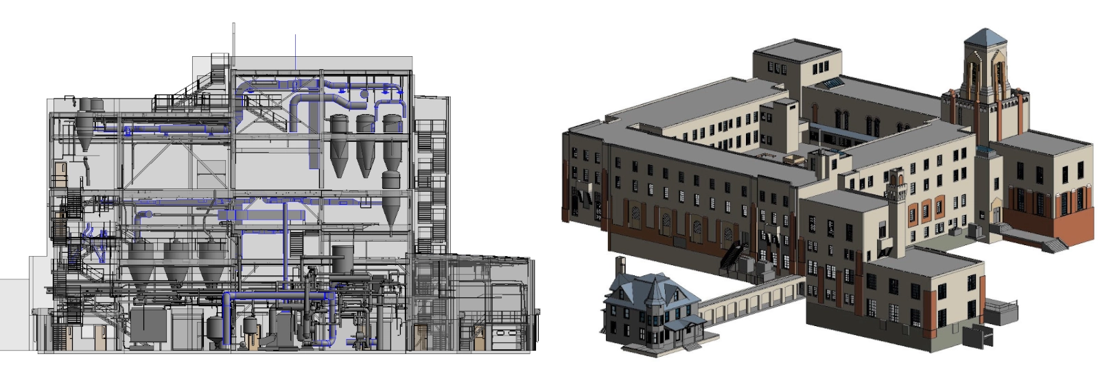
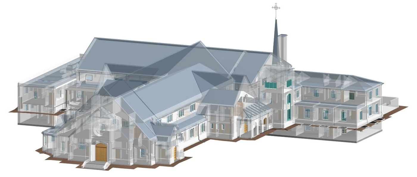
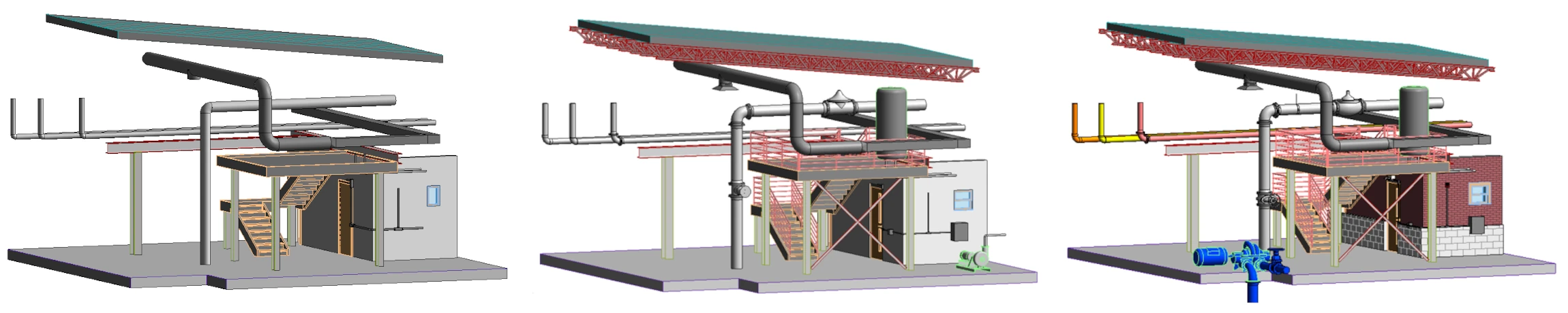
A BIM model is constructed using specialized software like Autodesk Revit or Bentley MicroStation, which allows users to create intelligent 3D representations of building components embedded with additional data. The process usually starts by importing point cloud data from 3D laser scans. Then, this data is modeled into architectural, structural, and MEP elements. Each element has precise geometry and metadata.
A BIM model integrates a wide range of data layers to create a comprehensive, intelligent representation of a building or infrastructure. These layers include:
- Geometry: Detailed 3D representations of building components such as walls, doors, windows, and structural elements.
- Material Specifications: Information about the type, quantity, and performance characteristics of materials used.
- Spatial Relationships: Data showing how components connect, align, and interact within the structure, including adjacency, elevation, and orientation.
- Geographic Data: Site-specific information such as coordinates, topography, and environmental context, useful for solar studies, wind analysis, and geospatial planning.
- Quantities: Material takeoffs, dimensions, and counts of components used for estimating costs and managing procurement.
- Component Properties: Detailed attributes like fire ratings, thermal performance, manufacturer information, and maintenance requirements.
- Cost Estimations: Budgeting and financial planning data derived from quantities and specifications within the model.
- Scheduling: Construction sequencing, task timelines, and resource allocation to support project planning and execution.
- Facility Management Data: Operational details, including maintenance schedules, equipment warranties, and asset tracking for long-term building management.
Together, these elements form a unified digital BIM environment that enhances collaboration, reduces errors, and supports informed decision-making throughout the entire lifecycle of a building.
What Can BIM Be Used For?
BIM is a versatile tool with applications that extend far beyond design and construction, supporting every phase of a building’s lifecycle and enhancing collaboration, efficiency, and decision-making across disciplines. Here are some use case examples for BIM:
Design Visualization – Architects and engineers use BIM to assess the existing conditions, visualize the design, and simulate how the building will function throughout its lifecycle.
Clash Detection – BIM helps identify conflicts between MEP systems early in the design phase to prevent costly rework.
Construction Planning – Contractors use BIM to sequence tasks, coordinate with trades, manage timelines, and optimize resource allocation.
Cost Estimation – BIM models include material quantities and specifications, enabling accurate budgeting and financial forecasting.
Facility Management & Upgrade – Building owners use BIM to track maintenance schedules, equipment warranties, assess space utilization, and plan for upgrades.
Renovation and Retrofit Projects – BIM provides detailed as-built data that helps teams plan upgrades without disrupting existing systems.
Historic Preservation – BIM helps architects preserve unique architectural features and integrate modern systems to meet safety codes, accessibility requirements, and energy efficiency standards, ensuring that the building remains functional while honoring its historical value.
Energy Analysis – Engineers use BIM to simulate energy performance and optimize HVAC, lighting, and insulation systems.
Prefabrication – BIM provides exact measurements to produce building components off-site with precision, reducing waste and labor costs.
Regulatory Compliance – BIM helps ensure designs meet building codes, accessibility standards, and safety regulations.
Virtual Tours – BIM models can be used to create immersive walkthroughs for contractors, clients, and investors.
Disaster Planning and Risk Mitigation – BIM can simulate emergency scenarios such as fire, flooding, or structural failure to help design safer buildings and plan evacuation routes or disaster response strategies.
Asset Management and Lifecycle Tracking – Beyond facility maintenance, BIM can track the lifecycle of individual assets, for example HVAC units or elevators, including installation dates, service history, and expected replacement timelines.
Site Logistics and Construction Safety – BIM can be used to plan site logistics, such as crane placement, material staging, and worker movement, helping to improve safety and efficiency on construction sites.
Infrastructure and Civil Projects – BIM is not limited to buildings; it’s also used for roads, bridges, tunnels, and utilities, integrating geospatial data and civil engineering models for large-scale infrastructure planning.
Sustainability and LEED Certification – BIM supports green building initiatives by modeling daylighting, water usage, and energy efficiency, helping teams meet LEED or other sustainability certification requirements.
Digital Twin Integration – BIM serves as the foundation for digital twins, providing real-time data connected to buildings for monitoring performance, predictive maintenance, and operational optimization.
What is the Role of Laser Scanning in BIM?
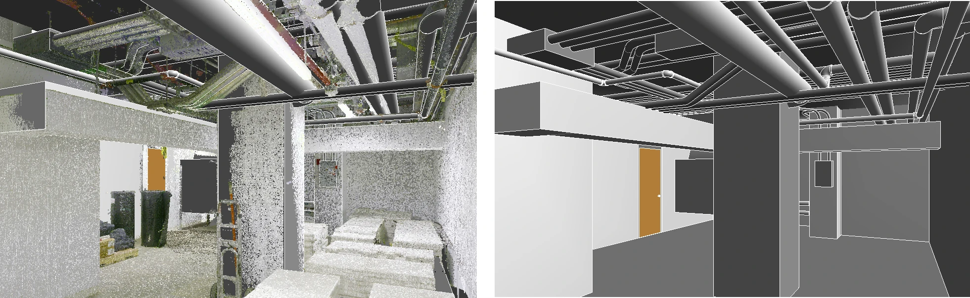
3D laser scanning plays a critical role in Building Information Modeling by capturing millions of precise data points that represent the exact geometry and spatial relationships of existing structures. Using 3D laser scanning equipment, technicians collect data in the form of a point cloud, which they then process and convert into intelligent 3D BIM models using software like Autodesk Revit, AutoCAD, and Bentley MicroStation. These models provide a highly accurate digital representation of architectural, structural, and MEP systems,
Laser scanning is ideal for BIM because it offers:
- High accuracy
- Rapid data collection
- Safe documentation of hard-to-reach areas
- Comprehensive coverage of architectural, structural, and MEP systems
BIM enables teams to design, plan, and manage projects with confidence and minimal risk of error.
What are the Levels of Detail (LOD) in BIM?
LOD is the set of specifications that gives AEC professionals the power to document, articulate, and specify BIM models effectively. By using LOD specifications to scope their projects, architects, engineers, and other professionals can clearly communicate the precision requirements of the BIM model for faster project execution.
BIM models can be customized based on the required Level of Detail (LOD). GPRS offers three tiers:
- Standard Detail: Basic geometry and layout.
- High Detail: Includes architectural features and major MEP components.
- Very High Detail: Comprehensive modeling of all building systems, down to individual components.
What BIM Deliverables Can Be Created?
BIM deliverables can be tailored to meet the specific needs of each project and stakeholder. Here are some of the deliverables that can be created from 3D laser scan point cloud data:
- Point Clouds: Raw scan data in formats like .rcs or .e57.
- 2D CAD Drawings: Floor plans, elevations, sections, and reflected ceiling plans.
- 3D BIM Models: Intelligent models for design, construction, and facility management.
- 3D Mesh Models: Surface representations for visualization and analysis.
- Virtual Tours: Interactive walkthroughs for stakeholder engagement.
- TruView and JetStream Viewer Files: Tools for viewing and interacting with scan data.
These deliverables support various workflows, from design and prefabrication to maintenance and renovation.
What Software Can Create BIM?
Creating a BIM model requires specialized software that supports intelligent modeling, data integration, and interoperability. Here are some of the most widely used software in the industry:
Visit Autodesk Revit
Visit AutoCAD Civil 3D
Visit Autodesk Navisworks
Visit Bentley MicroStation
Visit ClearEdge EdgeWise
Visit Leica TruView Desktop
What Are the Applications of BIM Across Industries?
BIM is not limited to architecture or construction, it is a powerful tool used across a wide range of industries to improve planning, execution, and asset management. Here are some industries where BIM is making a significant impact:
- Architecture: Design visualization and documentation
- Engineering: Structural analysis and system integration
- Construction: Scheduling, cost estimation, and clash detection
- Facility Management: Maintenance planning and asset tracking
- Healthcare: Space planning and compliance
- Education: Campus renovations and expansions
- Retail: Store layout and rollout planning
- Manufacturing: Equipment installation and upgrades
- Energy: Power plant design and retrofits
- Telecommunications: Infrastructure planning and optimization
BIM is not limited to large-scale projects. It adds value to projects of any size, whether it’s a small renovation or a complex facility upgrade, by improving planning, coordination, and execution. GPRS has completed hundreds of BIM projects across these industries, delivering models that support efficient planning and execution.
Learn more about industries served.
What are the Benefits of BIM?
BIM offers a wide range of benefits that enhance collaboration, reduce risk, and improve project outcomes across the board. BIM enables engineers, contractors, and architects to work on a single project from anywhere in the world. It condenses a plethora of information about every detail into a workable format. It makes for easier design, simpler coordination between team members, and easier structure maintenance across the entire built environment, and this is just the beginning. Some benefits of using BIM include:
- Real-time access to building information
- Accurate project planning
- Improved communication across project teams
- Model-based cost estimation
- Visualization of projects in pre-construction
- Identification and mitigation of clashes
- Improved scheduling and sequencing
- Precise prefabrication of building components
- Reduced errors and rework
What is the Real-World Impact of BIM?
A study from Dodge Data and Analytics, “Measuring the Impact of BIM on Complex Buildings,” found these results from AEC pros:
- 93% said BIM improved the quality/function of the final design
- 88% said BIM led to an accelerated job completion
- 85% said BIM resulted in a reduction in the final construction cost
AEC companies are realizing that planning virtually before beginning construction brings huge cost and time savings. The AEC industry is going through a digital transformation, trending to digital twins, and this means data rich 3D BIM models are a must.
Building Information Modeling is revolutionizing the AEC industry by providing a unified platform for design, construction, and facility management. By applying 3D laser scanning, clients receive highly accurate, data-rich models that support efficient project execution and long-term asset management.
Whether you are planning a new build, renovating an existing structure, or managing a facility, BIM offers the tools and insights needed to succeed. By embracing BIM, stakeholders can reduce costs, improve collaboration, and build with confidence.
How Can GPRS Help You?
GPRS is a leading provider of 3D laser scanning and BIM services in the United States, delivering accurate as-builts, point clouds, 2D CAD drawings, and 3D BIM models to expedite project planning. Our elite team of Project Managers utilizes state-of-the-art equipment, software, and processes to document architectural, structural, and MEP system layout and dimensions for existing buildings, facilities, and sites.
To learn more about BIM for architects, BIM for engineers, BIM for contractors, BIM for facility management, or BIM for infrastructure, click here.
For 3D laser scanning and BIM modeling services and pricing, call 419-843-7226 or email Laser@gprsinc.com.
What can we help you visualize?
Frequently Asked Questions
How Long Does 3D Laser Scanning Take?
GPRS has Project Managers across the country, allowing us to respond quickly with detailed quotes. Most jobs can be scanned in just a few hours, while larger sites may take a few days. Scanning entire facilities or campuses can take weeks. Yet, most projects are completed in hours or days.
How is 3D Laser Scan Data Registered?
The registration process is a collaborative effort. Registering a 3D laser scan point cloud involves aligning multiple scans of the same area taken from different positions into a single, coherent point cloud. This typically involves using specialized software like Autodesk Recap to import the data and align the scans. The Mapping & Modeling Team uses the software to spot overlapping areas in different scans. It captures the same physical features from slightly different angles. This helps the software identify corresponding points. Unwanted “noise” can be cleaned or deleted from the point cloud. Autodesk Recap software can remove unwanted data or noise. This includes reflections, moving objects, and background clutter. As a result, it creates a clean point cloud that shows the target project area. Proper registration ensures 3D laser scan measurements are accurate. This data can be exported for use in CAD or BIM software like Revit or AutoCAD.
How is 3D Laser Scan Data Processed?
At GPRS, once a site is scanned, we process the raw point cloud data by combining individual scans. We remove unwanted noise and convert the data into usable formats like 2D drawings or 3D models. The level of detail depends on the project’s needs, ranging from basic visuals to complex models. GPRS follows a structured workflow focused on accuracy, teamwork, and planning. We ensure efficient project execution. Our deliverables are high quality and tailored to each client's needs.