

.svg)
GPRS helped locate all underground sewer and sanitary lines throughout a 19-acre apartment complex in Tulsa, Oklahoma.
The complex’s facility manager had no existing records of their 1950s-era subsurface infrastructure and was not aware of the current conditions of these lines. They needed an updated map of the built world beneath their feet.
GPRS Project Manager Joe Meyer was tasked with investigating the complex’s sewer and sanitary lines and provide a NASSCO-certified report on all blocked, defective, or obstructed pipes along with the map, so they could effectively plan repairs and maintenance.
All GPRS Project Managers are NASSCO (National Association of Sewer Service Companies) certified in pipeline (PACP), lateral (LACP), and manhole (MACP) assessments.
GPRS Project Managers use the Envirosight ROVVER X Mainline Crawler to capture photo and video evidence of defects and other issues along sewer and stormwater lines. This remote-controlled rover can crawl as far as 1,640 feet into a sewer line and can adapt to inspect lines from 6” to 96” in diameter.
The ROVVER X SAT Lateral Launch camera can inspect sewer laterals from the mainline to identify any damages or defects, including cross bores, so clients can properly address them.
Push cameras, also known as flexible rodders, are used by GPRS Project Managers to access smaller spaces that crawlers can’t fit in, like vents, cleanouts, and toilet plumbing. The push camera also contains a sonde that can be detected by an electromagnetic (EM) locator to map non-metallic pipes.
“For this job, I inspected and located 3,411 linear feet of underground pipes, including 1,823 feet of sanitary and storm sewer mainline and 1,588 feet of sanitary sewer lateral lines,” Meyer said.
The 75-year-old infrastructure presented challenges Meyer had to overcome, including the design of the pipes.
“There was no sweep to the clean outs, they were straight 90 [degrees], so there was some trouble trying to get the camera to swoop into them,” he explained. “That was a challenge, but I was able to overcome that by using that SAT launcher from the mainline and when I got one halfway, I could meet up with the other [from the other side of the mainline].”
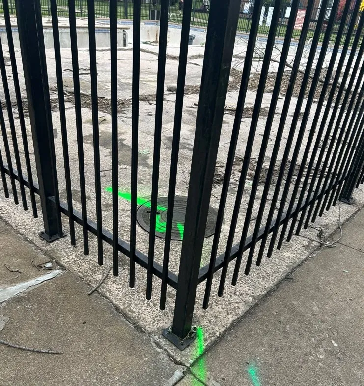
Meyer also found himself getting creative to access manholes that were in difficult to access locations.
“There was a gated swimming pool area that had a manhole right in the corner of the gate,” he said. “I had to set up in a weird way, so that was kind of fun, but I overcame that challenge.”
This job was conducted during the first week of June, so Meyer was faced with a fun challenge since summer vacation had begun for the kids in the neighborhood.
“It was right when school got let out, so all my flags disappeared overnight,” Meyer said. “That was pretty funny, so I didn't put any more flags down after that once I knew that they were all fair game. There were tons of kids around and there were some of them having fun watching what I was doing and seeing me test my crawler.”
Once he finished his investigation, Meyer provided the client with a map depicting the location of their sewer and sanitary lines via SiteMap® (patent pending), GPRS’ cloud-based infrastructure mapping platform. With SiteMap, the client can securely access their records 24/7 as they plan any upcoming renovation or restoration projects.

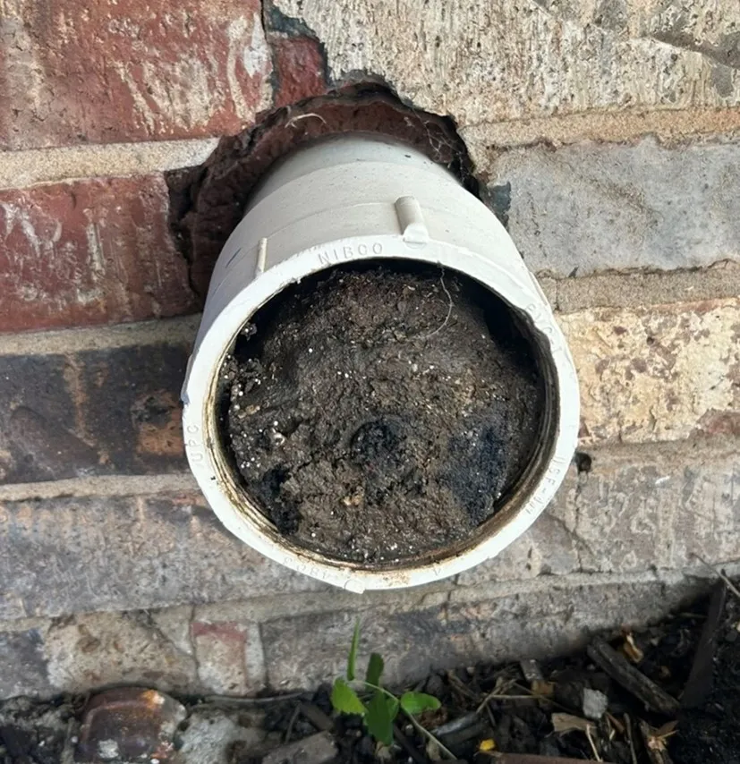
A NASSCO-certified Video Pipe Inspection report was created detailing the condition of the pipes and ranking defects by severity. Meyer did find some obstructions within the pipes that he was able to relay to the client so they can make necessary repairs.
“I found I had three units that did not have an external clean out and I could not access it from the main[line],” Meyer explained. “I also found a few clean outs that were completely full of dirt that maintenance had to come take care of while I was there. And I gave them a list, with priority, of what they can work on, so, all in all, it was helpful for them, even beyond just the mapping.”
Even, with the hurdles to overcome, Meyer completed his work within the client’s timeline.
“Everything really went well and it went on time as expected,” Meyer explained. “I kept in contact with the site contact and he was appreciative of that.”
From sewer line inspections to skyscraper scans, GPRS Intelligently Visualizes the Built World® to keep your projects on time, on budget, and safe.
What can we help you visualize?
FREQUENTLY ASKED QUESTIONS
What size sanitary sewer and stormwater pipes can GPRS inspect with its Video Pipe Inspection service?
Our elite, NASSCO-certified VPI Project Managers have the capabilities to inspect pipes from 2” in diameter and up.
What deliverables does GPRS offer when conducting a VPI?
GPRS is proud to offer WinCan reporting to our Video Pipe Inspection clients. Maintaining sewers starts with understanding sewer condition, and WinCan allows GPRS Project Managers to collect detailed, NASSCO-compliant inspection data. GPRS Project Managers not only inspect the interior condition of sewer pipes, laterals, and manholes – they can also provide a map of their location. The GPRS Mapping & Modeling Department can provide detailed GPS overlays and CAD files. Our detailed WinCan/NASSCO reports contain screenshots of the interior condition of the pipe segments that we inspect, as well as a video file for further evaluation, documentation, and/or reference.