

.svg)
GPRS helped their client in Denver, Colorado tackle an issue that has been plaguing them for years. GPRS Project Manager Matthew Pudimott and Area Manager Ryan Shannon were tasked with scanning a seven-acre parking lot outside of Empower Field at Mile High, the home stadium of the Denver Broncos.

The pavement in the parking lot had been continuously cracking despite repeated attempts to repair it.
The parking lot was built where a former Denver arena once stood, McNichols Sports Arena was built in 1975. It held hundreds of concerts and was the home of the Denver Nuggets from its inaugural year until it officially closed in 1999. McNichols was also the home of the Colorado Avalanche for the final four years it was in operation. In January of 2000, it was demolished to make way for the construction of Empower Field at Mile High.
The initial purpose of the project was to search for underground tunnels or possible buried remains from the former arena. Pudimott and Shannon got to work and began scanning the area using ground penetrating radar (GPR).
The results were not as conclusive as they expected, so they implemented one of the main guidelines of Subsurface Investigation Methodology (SIM): the use of multiple complimentary technologies. They scanned the same area using electromagnetic (EM) locators and found what they were looking for.
“We initially were searching for voids, so we ran the GPR cart, took a whole day to get all the data together, and there was just no evidence of voids,” Pudimott explained. “We started to get worried that we actually weren't going to have meaningful results for the client, but the next day we ran EMI and that was kind of interesting. Same thing, collected the whole result, took a full day, and I was hoping we'd have something for him. And when the post processing data came back, I mean, it blew up.”

EM locators are used to detect electromagnetic signals radiating from metallic pipes and cables. Signals are created by the current flowing from the EM locator’s transmitter which travels along the conductive materials and back to the transmitter. Signals can be created and registered by the equipment when:
- The EM locator’s transmitter applies current to the pipe
- An electrical cable is live with current flow
- A conductive pipe acts as an antenna and re-radiates signals from stray electrical fields and communication transmissions
Once they saw the unusual results from the scan data, Shannon had an idea that allowed them to properly tell the data’s story.
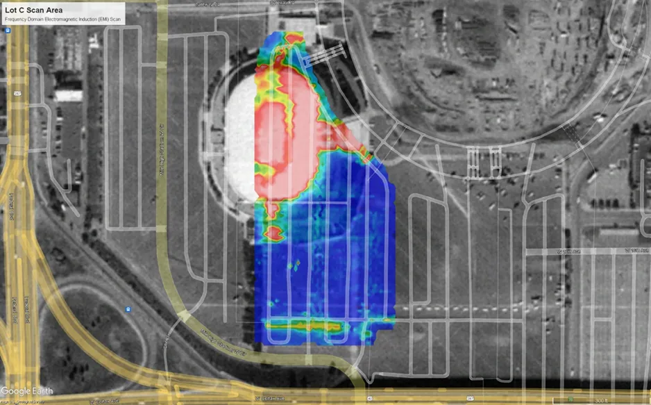
“We definitely found a huge reaction and I knew that [McNichols] stadium was built there and that's probably the reason why we were scanning out there. So I just figured I would look at the old Google Earth data,” Shannon explained. “Sure enough, that popped up there, and then I thought to overlay that data over the historical data. It was most likely old foundations or possibly different backfill. The red, white, and orange reactions on the EMI typically indicate conductive reactions.”
Once Shannon overlayed aerial imagery from October of 1999, the EM data appeared to align with the footprint of the former arena.
Despite being with GPRS for over a decade, Shannon couldn’t help but be amazed at the uniqueness of this job and the capabilities of utility locating equipment.
“This is definitely once-in-a-lifetime data, for sure,” Shannon said. “It’s not a common example, but a great example of what the EMI can do to get this data consistently. To find a building footprint like this? Yeah, I've never heard of this before or seen it before.”
With these results now at the client’s fingertips, they can make educated decisions on how to fix the parking lot without wasting more time and money on renovations year after year.
From stadiums to sewer lines, GPRS Intelligently Visualizes the Built World® to keep your projects on time, on budget, and safe.
What can we help you visualize?
FREQUENTLY ASKED QUESTIONS
What is Subsurface Investigation Methodology?
Subsurface Investigation Methodology (SIM) is a standard operating procedure and set of professional specifications that work as a guide for utility locating experts when scanning for buried utility lines. All GPRS Project Managers are required to achieve SIM 101 certification, which requires 80 hours of hands-on training in a classroom setting and 320 hours of mentorship in the field. For reference, the American Society for Nondestructive Testing’s (ASNT) minimum training recommendation includes eight hours for training and 60 hours practicing GPR to achieve NDT Level 1 certification in ground penetrating radar (GPR) scanning.
SIM requires the use of multiple, complementary technologies, like GPR scanning and electromagnetic (EM) locating, when locating buried utilities or scanning a concrete slab.
What are the Benefits of Underground Utility Mapping?
Having an updated and accurate map of your subsurface infrastructure reduces accidents, budget overruns, change orders, and project downtime caused by dangerous and costly subsurface damage.