

.svg)
GPRS Reality Capture Services collected accurate, actionable data to expedite upgrades to a nearly 100-year-old hydroelectric dam.
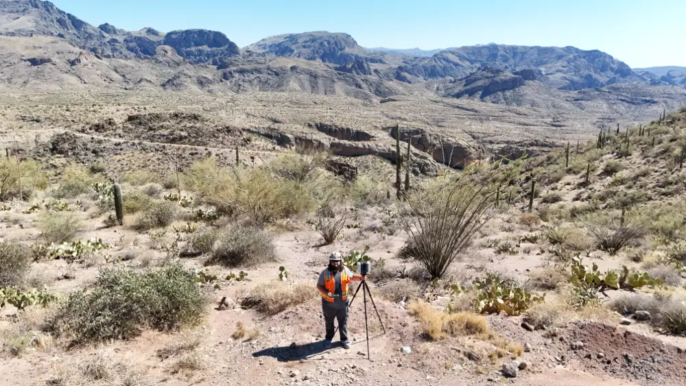
Project Manager Dean Sturt was called out to the dam to conduct 3D laser scans of its two powerhouses, in preparation for upcoming renovations.
Situated at the foot of the dam, the powerhouses are each multi-story buildings densely packed with complex mechanical and electrical systems. There were no existing, accurate plans of the buildings. The project team needed to know exactly where every pipe, transformer and structural element was inside each of the powerhouses to effectively plan upgrades to the facility.
Accurate, real-time as-built data is essential for informed decision-making and seamless collaboration. With precise design plans from the start, architects, contractors, engineers, and facilities managers can streamline fieldwork and minimize change orders, plus avoid delays and extra costs.
GPRS 3D Laser Scanning Services provide clients with precise as-built documentation of buildings and infrastructure using advanced Leica laser scanners, delivering point clouds, 2D CAD drawings, and 3D BIM models to streamline project planning and construction.
GPRS Project Managers begin every project by speaking with on-site personnel and conducting a site walk to understand the unique elements of the project they’re about to begin. Sturt spent three hours walking the dam with its operations team.
“We walked it top-to-bottom, the whole facility, just so that I could mentally game plan where to start, how many floors there were, etc.,” he said. “They didn’t have any plans of the facility to start from, so it wasn’t like going into it I already had a base to go off. So, I walked it with those guys, asked a lot of questions.”
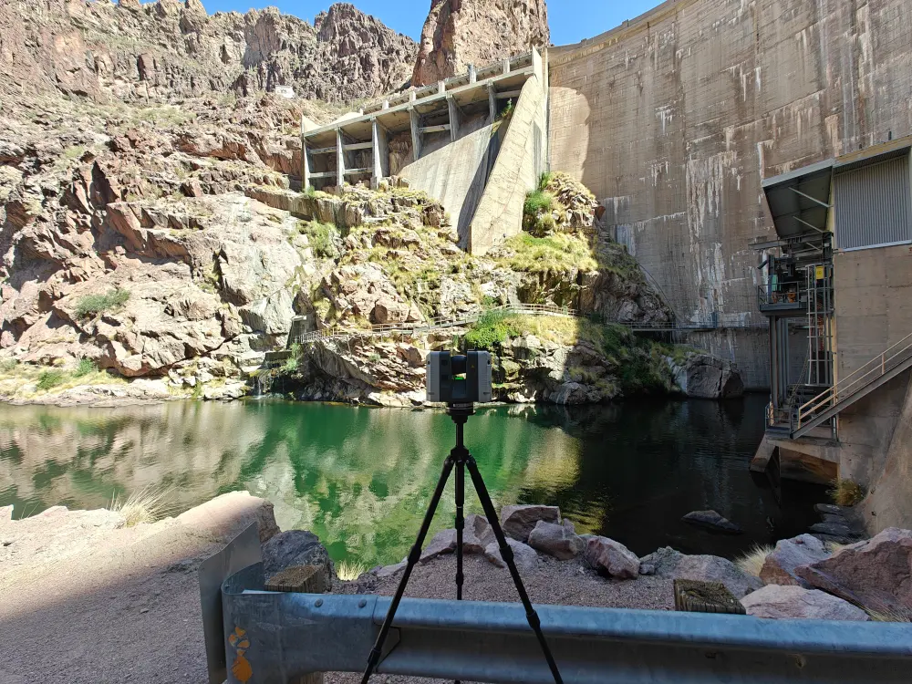
Over the next several days, Sturt scanned every inch of the two powerhouses and surrounding structure, capturing the accurate data necessary to create the as-built documents the client required.
“It was a little daunting at first, just those dense areas, a lot going on in kind of a small space,” he said. “But as you start going through it, it made a lot more sense.”
The point cloud data generated from Sturt’s scans was turned over to GPRS’ in-house Mapping & Modeling Team, where it was used to build a 3D model, virtual walkthrough, and 2D floor plans of the dam’s power infrastructure.
Our Mapping & Modeling Team can create anything from a simple GPS-enables locating map of your utility locate, to highly detailed 2D CAD drawings and 3D BIM models, depending on your needs.
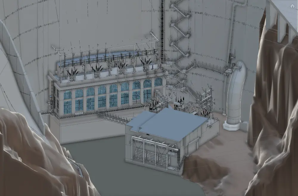

“[The customer] wanted a full 3D model of both powerhouses, so the additional topography and the rest of the dam [shown in the deliverables] is pretty much just for reference,” explained GPRS Senior Modeling Technician Nate Nowels. “We were responsible for modeling all the equipment structural components, and all the architectural features… It was structural beams, columns, trusses, all the architectural elements, and then into the mechanical systems. So, ducts, the footprints of actual equipment, we got pipes and all that kind of stuff, valves, actuators, everything… All the mechanical items were captures.”
Nowels said that modeling the complex mechanical systems inside the powerhouses did present its own unique set of challenges.
“There were pieces of equipment that ran through multiple floors,” he explained. “With a lot of factories, you’ll have some equipment that runs from, say, level one to level two. But in powerhouse two, for example, there’s a turbine that runs all the way down into the water and then up through multiple layers. It’s a very unique object to model; it has lots of mechanical piping going in and out of it.
“It’s multiple levels of a piece of equipment running through multiple floors…,” Nowels continued. “You wouldn’t want your entry level engineer or designer on it. You need to have extensive knowledge of the [modeling] software, for sure.”
The data provided to the client by GPRS will allow them to accurately and efficiently plan their upgrades to the hydroelectric dam.
“They have nice existing condition documentation of [this equipment on] the day that we scanned it,” Nowels said. “And they’re able to tie into all the mechanical systems, HVAC systems, and add on however they need to add on.”
GPRS turns your built world into easily accessible and accurate data.
What can we help you visualize?
Frequently Asked Questions
How is 3D laser scan data registered?
The registration process is a collaborative effort. Registering a 3D laser scan point cloud involves aligning multiple scans of the same area taken from different positions into a single, coherent point cloud. This typically involves using specialized software like Autodesk Recap to import the data and align the scans. The Mapping & Modeling Team uses the software to find overlapping areas between different scans where the same physical features are captured from slightly different angles, allowing the software to identify corresponding points.
Silbaugh says unwanted “noise” can be cleaned or deleted from the point cloud. Autodesk Recap software can isolate and delete extraneous data or noise, such as reflections, moving objects, or background clutter, leaving behind a refined point cloud representing the desired project area. Proper registration ensures that measurements taken from the 3D laser scans are accurate and the data can be exported for use in CAD or BIM applications like Revit or AutoCAD.
How long does laser scanning take?
With Project Managers all over the U.S., we work quickly to provide detailed quotes for clients. For most jobs, large areas can be laser scanned in as little as a couple of hours or larger sites in as little as a few days. Entire facilities or campuses can take several weeks to capture the entire site, but most projects are measured in hours or days.