

.svg)
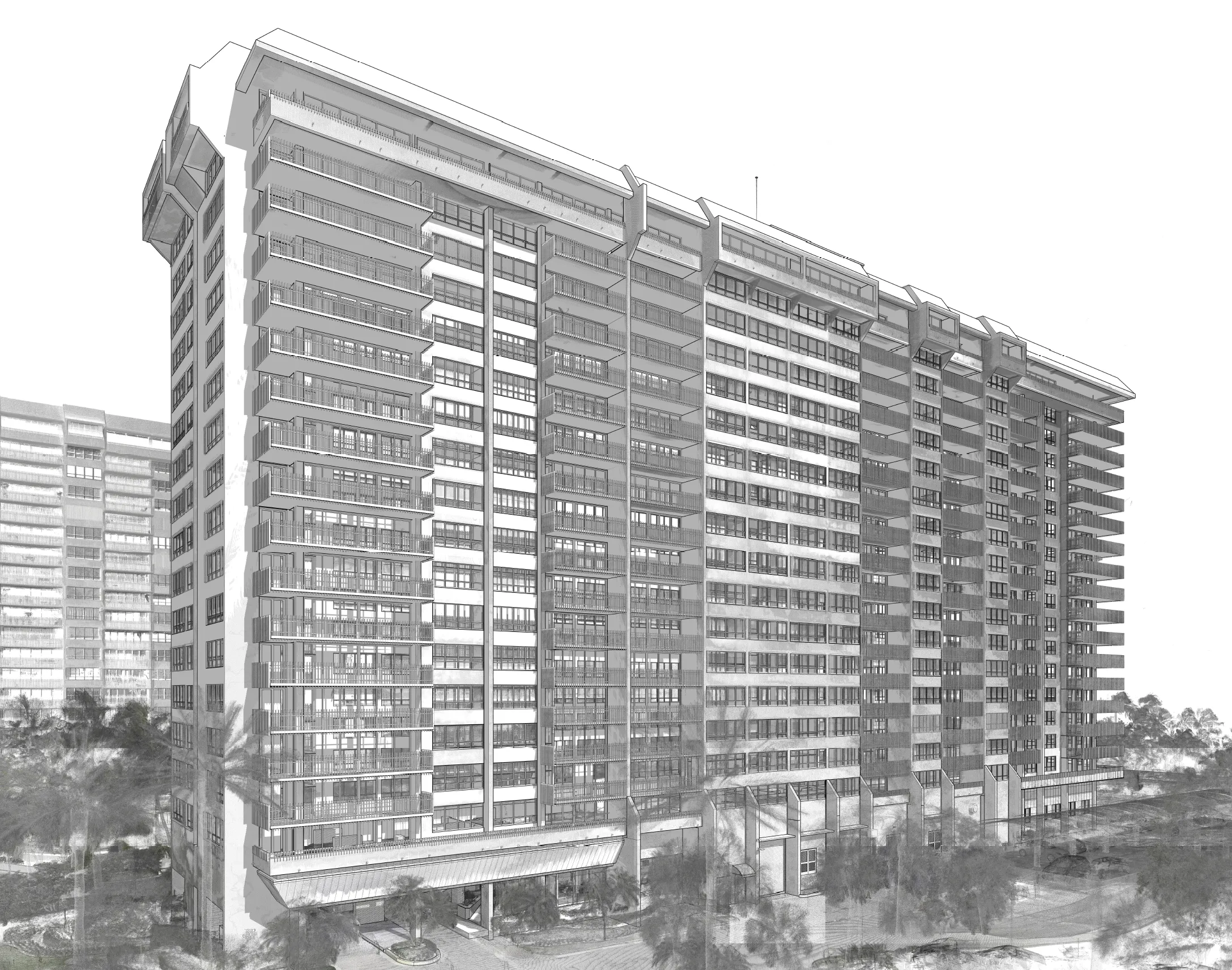
A decades-old, luxury condominium complex on a man-made island off the southern coast of the United States was set to undergo renovations to bring the buildings into ADA compliance.
The contractor overseeing the project called GPRS to provide reality capture services that ensured their work started accurate and stayed accurate.
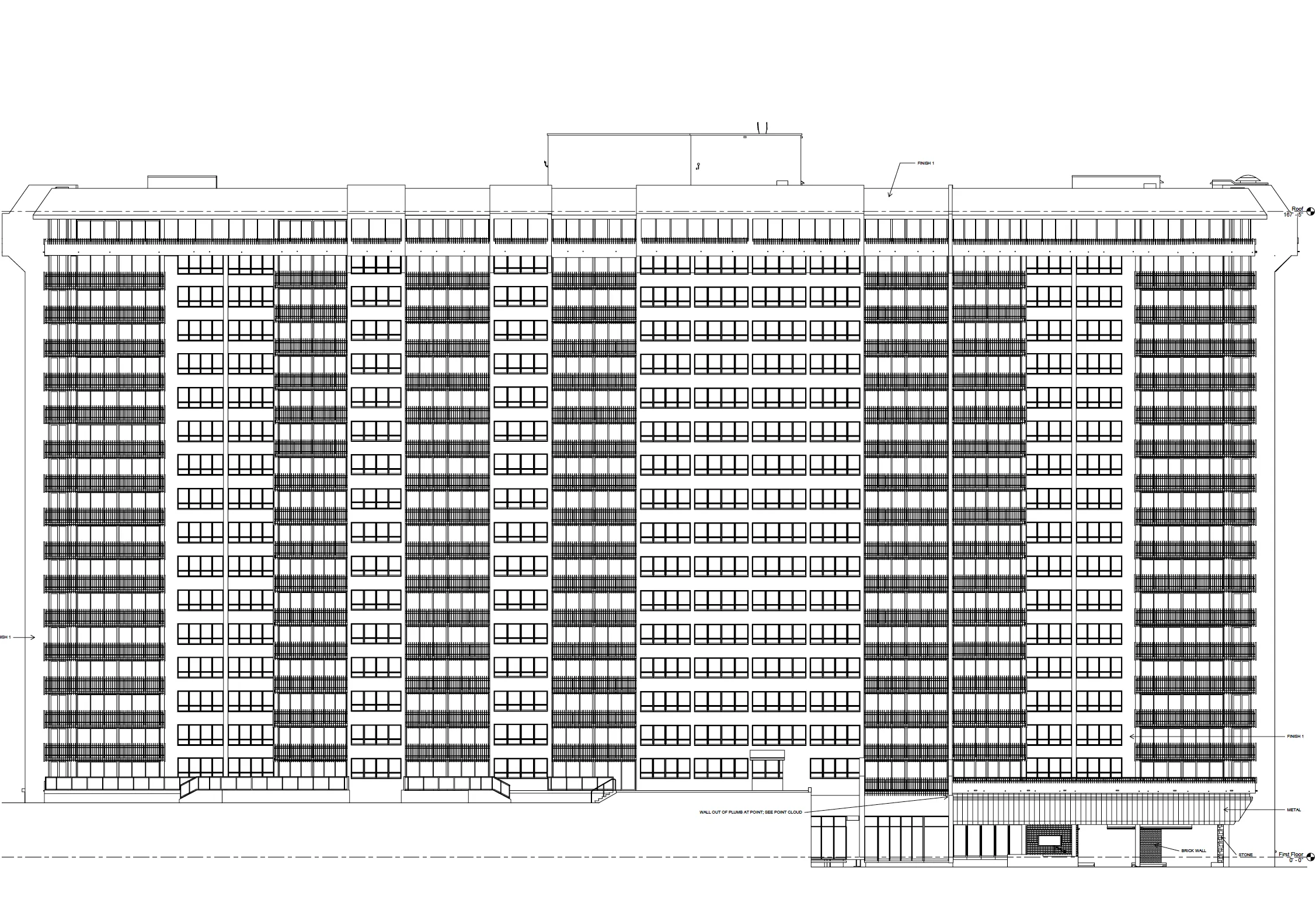
Project Manager John Lehaney traveled to the island to conduct 3D laser scans in and around the three existing towers. Our client required accurate floor plans of the first floors, and scans of the exteriors of each of the three buildings to expedite project planning. But data capture needed to be completed without disrupting tenants and while working around the active construction of an additional condo tower on the island.
The scope of work also tripled in size as the client came to fully understand what data they required to complete their project.
“It went from being about, I want to say, 9-10,000 s.f. of building [scanning]… to around 30,000 s.f. of building,” Lehaney said. “So, it consisted of the lobby, the carports, community spaces, storage lockers, staff housing, and then one of the buildings, instead of staff housing, [we needed to scan] what was actually a tenant’s condo unit. So, we had to get special access to get in there from security.”
What Does it Mean to be ADA Compliant?
The Americans with Disabilities Act (ADA) is a federal law that prohibits discrimination based on disability and ensures equal access and opportunities for individuals with disabilities in various area, including employment, transportation, public accommodations, and communications
For buildings, ADA compliance means physical accessibility through the inclusion of features like ramps, accessible restrooms, and clear pathways.
How GPRS Helps You Comply with ADA Requirements
GPRS offers reality capture services that can be used to inspect ramps and cross slopes – the angle of a road’s surface perpendicular to the direction of travel, designed to allow water to drain away effectively – to ensure they comply with ADA requirements.
When you need to renovate to achieve compliance, our laser scanners collect the accurate, actionable data that our in-house Mapping & Modeling Team needs to create floor plans, virtual walkthroughs, BIM models, and whatever other deliverables you need to get the job done right.
At the condos, Lehaney deployed the Leica RTC360 and P50 ScanStation to obtain the desired point cloud data.
The Leica RTC360 3D laser scanner combines a high-performance laser scanner with Cyclone FIELD 360, a mobile-device app on a tablet computer, to capture and automatically pre-register scans in real time. With a measuring rate of up to 2 million data points per second and advanced HDR imaging system, you can have 3D colorized point clouds with 2-4 mm accuracy in under 2 minutes. Automatic targetless field registration (based on VIS technology) and the seamless transfer of data from site to office reduces time spent in the field, maximizing project productivity.
Leica P-Series ScanStations deliver the highest quality point cloud data and HDR imagery at an extremely fast scan rate of up to 1 million points per second and ranges of more than 1 kilometer. The P-series Leica laser scanners can tie to survey control, achieve 2-4mm accuracy and have real-time liquid filled dual axis compensators to help mitigate movement and ensure level scans. These scanners deliver highly detailed point clouds mapped in realistic clarity.
With this equipment, Lehaney was able to collect the data needed for GPRS’ Mapping & Modeling Team to create the floor plans and other deliverables the client needed to complete their work efficiently, and without the delays and mistakes they would have incurred without accurate as-built information.
“Overall, it was a pretty smooth project,” he said. “[The data] came out nice and clean… It’s just good data for them to have, including the hardscape information outside the building too.”
From condo towers to municipal sewer systems and everything in between, GPRS Intelligently Visualizes The Built World® to keep your projects on time, on budget, and safe.
What can we help you visualize?
Frequently Asked Questions
How do I know if 3D laser scanning or other reality capture services are right for my project?
Almost any project that requires as-built information can benefit from a laser scanning survey. Talk with our experts and start your 3D laser scanning survey project today.
What deliverables can GPRS provide when conducting reality capture services?
We can provide 3D modeling in many formats such as:
- Point Cloud Data (Raw Data)
- 2D CAD Drawings
- 3D Non-Intelligent Models
- 3D BIM Models
- JetStream Viewer
Customizable Deliverables Upon Request
- Aerial Photogrammetry
- Comparative Analysis
- Deformation Analysis
- Digital Drawings of GPR Markings
- Floor Flatness Analysis/Contour Mapping
- New Construction Accuracy Analysis/Comparative Analysis
- Point Cloud Modeling Training Webinars
- Reconciliation of Clients 2D Design Drawings
- Reconciliation of Clients 3D Design Model
- Structural Steel Shape Probability Analysis
- Template Modeling
- Volume Calculations
- Wall Plumb Analysis