

.svg)
GPRS BOMA Measurement Services
Fast. Accurate. Compliant.
GPRS delivers BOMA compliant lease plans and area analysis that help property owners maximize value and manage buildings with confidence. Our services support offices, industrial facilities, retail centers, multi-family and hospitality properties, and mixed use developments. We provide clean, accurate plans with minimal disruption and a rapid turnaround, ensuring your projects start on time and operate efficiently.
Who Uses BOMA Lease Plans & Area Analysis
BOMA lease plans and area analysis are primarily used by businesses involved in commercial real estate, property management, and facilities operations. They provide standardized, accurate measurements of usable and rentable space, which are critical for leasing, valuation, and compliance.
This list summarizes the different stakeholders who benefit from BOMA-standard area measurements and lease documentation, along with the specific ways they use that data.
- Property Owners and Landlords: Ensure fair and consistent rentable area calculations, maximize revenue, and increase property value.
- Property Managers: Use lease plans to manage tenant spaces, reduce disputes, and streamline lease administration.
- Commercial Real Estate Investors and Appraisers: Rely on accurate area analysis for due diligence, valuation, and acquisition decisions.
- Facilities Managers: Apply BOMA data to optimize space utilization, plan renovations, and manage building operations.
- Architects and Designers: Use lease plans as a baseline for tenant improvements, reconfigurations, and compliance with building standards.
- General Contractors and Builders: Rely on precise measurements for construction planning, retrofits, and renovations.
- Corporate Tenants: Confirm that the leased space matches contractual obligations and supports workplace planning.
- Developers: Apply BOMA standards to calculate gross leasable areas, ensuring consistency across diverse property types.
- Financial Institutions: Use standardized lease area analysis to support lending, underwriting, and valuation reports.

What Technology Does GPRS Use for BOMA Lease Plans and Area Analysis
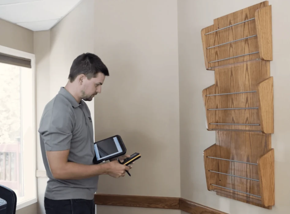
GPRS’ proprietary Building Surveyor software establishes a direct Bluetooth connection between a handheld laser measurement device and a tablet, enabling continuous real-time acquisition of spatial data points. The system automatically translates these inputs into vectorized wall line geometry within the CAD environment, ensuring immediate accuracy and traceability of measurement data. This eliminates manual steps, increases speed and accuracy, and allows our Project Managers to measure up to 25,000 square feet per day with an accuracy better than 0.2%.
The GPRS BOMA Measurement Process
- Real-time measurement capture: Project Managers begin in one corner of a room and trace the perimeter with a handheld laser. Each measurement is transmitted via Bluetooth directly to the tablet, where wall lines are drawn automatically.
- Error detection and correction: When the Project Manager completes the loop, the software compares the final point to the starting point. If the closure is outside a narrow tolerance, the system flags potential input errors or angled walls. The Project Manager rechecks measurements until the room closes perfectly, similar to a land survey.
- Room by room precision: This process is repeated for every room, regardless of size. By the time the survey is complete, the floor plan is fully documented using the appropriate BOMA standard, eliminating the need for costly return trips.
- Immediate spatial validation: Because measurements are captured in real time, Project Managers can confirm the correct placement of items such as sinks, counters, and furniture relative to other improvements.
- Advanced geometry: Curves and angles are easily documented by triangulating from known survey points, ensuring that complex layouts are captured with precision.
- Measuring speed: Vacant and open areas can be documented quickly, allowing Project Managers to move efficiently through the space. In contrast, heavily occupied, cluttered environments such as medical office buildings require more time and care to ensure every detail is captured accurately.
- Reality capture: 3D laser scanning can be employed to document hard-to-measure building features, detailed wall and ceiling decorations, and historic elements.
- CAD deliverables: Survey data is processed into CAD drawings within days after fieldwork, depending on project size. This rapid turnaround provides teams with reliable documentation to begin design, coordination, and construction without costly delays.
GPRS Supports These Industries for BOMA Measurement & Floor Plan Services
We provide partial or full building analysis based on standard type and analysis goals, covering:
- Office
- Industrial
- Retail
- Multi-Family & Hospitality
- Gross Areas
- Mixed-Use Properties

GPRS BOMA-Compliant Documentation and Deliverables
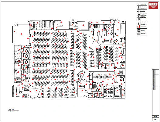
BOMA Lease Plans
For multi tenant office buildings over 20,000 SF, full BOMA lease plans provide clients with a comprehensive report that includes black and white dimensioned floor plans and colorized lease plans for each floor, highlighting rentable areas, tenant demises, and common spaces. These visual documents communicate the building’s spatial layout to owners, tenants, and contractors. Files are delivered digitally, including PDFs of all prints, CAD files for each floor, and site photos.
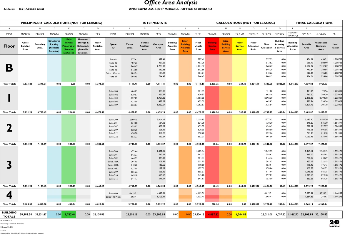
Lease Area Analysis
This report includes a color spreadsheet of BOMA lease area calculations prepared in accordance with current BOMA standards. This analysis determines the precise square footage of usable, rentable, and common areas by applying load factors and rules from the applicable standard (e.g., Office 2017 or 2024). The results provide clear spreadsheets and reports that quantify space for leasing, valuation, and revenue optimization.
Floor Plans
Floor plans provide the basic spatial layout of a building, showing architectural and structural elements such as walls, windows, doors, columns, stairs, cabinets, furniture, fixtures, water heaters, furnaces, fireplaces, electrical and gas meters, appliances, and more. These plans serve as a visual tool to conceptualize space and layout, enabling designers and contractors to discuss and refine ideas.
2D CAD Floor Plans
2D CAD floor plans are created using CAD software and contain detailed, precise building information. They include layout, dimensions, annotations, and material specifications for architectural, structural, and MEP system components. These plans are essential for design planning, technical documentation, obtaining permits, and guiding the construction process. They can include elevations, sections, details, isometric drawings, RCPs, and more.
Site Plans
Site plans document exterior constructed areas such as stairs, ramps, built in planters, landscaped and hardscaped areas, porches with columns and railings, decks, patios, trash enclosures, and loading zones in commercial buildings.
Height Plans
Height plans record door, window, and ceiling heights, as well as half walls, level changes, and floor to floor elevations.
Electrical Plans
Electrical plans identify the location and type of switches and outlets, including GFI and 220v, and specify whether they are surface mounted or recessed.
Reflected Ceiling Plans
Reflected ceiling plans, RCPs, are 2D CAD drawings that depict the ceiling as if reflected onto the floor plan. They document ceiling mounted light fixtures, drop ceiling grids, ceiling level changes, beams, ducts, and their heights relative to the finished floor. RCPs also include door chimes, speakers, emergency exit signs, fire strobes, sprinklers, motion sensors, security cameras, wall mounted lights, sconces, and other system components, supporting renovation and refurbishment planning.
Life Safety and Evacuation Plans
Life Safety and Evacuation Plans are occupant facing diagrams designed to meet fire code and OSHA requirements by visually identifying all critical life safety assets within a facility. These plans document egress paths, exit signage, emergency lighting, and the location of fire extinguishers, pull stations, strobe lights, smoke and heat detectors, and other emergency equipment. Their primary function is to provide building occupants with immediate guidance during an emergency, ensuring safe evacuation and rapid access to life saving devices. Plans are typically posted throughout the facility and must conform to regulatory standards for clarity, scale, and symbol usage.
Emergency Floor Plans
Emergency Floor Plans are technical plan view drawings used by facility managers, safety officers, and first responders to support preparedness and response protocols. They provide a comprehensive spatial representation of building layouts, mapping escape routes, fire suppression equipment, utility shut offs, and designated assembly points. Unlike occupant facing evacuation diagrams, these plans are integrated into emergency management systems, exported into digital formats, and maintained as part of a facility’s safety documentation. Their accuracy and interoperability with CAD and GIS platforms make them essential for training, incident response, and compliance audits, ensuring that emergency procedures are based on verified building data.
3D CAD Floor Plans
3D CAD floor plans provide a detailed and accurate representation of architectural, structural, and MEP components, including heights, widths, and depths. They deliver precise spatial data for buildings, sites, structures, or objects. These plans are critical for design, engineering, and construction, enhancing project planning, development, and execution.
3D Virtual Tours
3D virtual tours allow stakeholders to visually walk through a site for project planning. They support renovation proposals while minimizing interference with existing elements, help visualize equipment placement and inventory layout, and aid in developing emergency action procedures, safety protocols, and hazard identification.
Reasons to Use GPRS for BOMA Building Measurement Services
1. Receive Accurate Layout and Dimensions
Precise measurements provide a reliable foundation for design, leasing, and facility management. GPRS delivers BOMA-Compliant Floor Plans that document the true layout and dimensions of your property. These plans eliminate guesswork, ensure consistency across stakeholders, and serve as the baseline for space planning, tenant improvements, and long term asset management.
2. Create a BOMA Compliant “Snapshot in Time” for Area Analysis
A Snapshot in Time is a key concept in BOMA standards. It provides a record of your building’s layout and lease areas at a specific moment, reflecting either current conditions or proposed changes. This snapshot can incorporate tenant improvements, interior layout changes, or updates to newer BOMA standards. By maintaining this record, owners and managers can confidently perform Lease Area Analysis and re measurements, ensuring compliance and accuracy for leasing, valuation, and reporting.
3. Increase Rentable Area by 2–5% to Maximize Revenue
Re measurement often identifies additional rentable space. Updates to the BOMA Office Standards (2017 & 2024) favor property owners by including areas such as stairwells, elevator shafts on the ground floor, balconies, and roof decks. In many cases, rentable area increases by 2–5% simply by updating the Lease Area Analysis to the latest standards. This translates into higher income and increased property value, often with one of the fastest payback periods of any building investment.
4. Reduce Disputes and Stronger Lease Negotiations
BOMA compliant floor plans clearly define tenant spaces and rentable areas. This transparency reduces disputes, supports fair pricing, and provides documentation that both owners and tenants can trust. Lease negotiations and renewals are smoother when backed by impartial, third party data.
5. Powerful Marketing Tool
Accurate floor and lease plans are powerful marketing assets. Once digitized in CAD, they can be used to showcase tenant areas, proposed layouts, and revised rentable areas. These files enhance websites, brochures, and presentations, while also allowing instant sharing with prospective tenants.
6. Trusted Third Party Measurements
Tenants and investors place greater confidence in impartial, third party verification. GPRS provides measurements that ensure accuracy and credibility, strengthening trust between property owners and stakeholders.
7. Critical Due Diligence for Acquisitions
BOMA measurements are a critical part of due diligence when purchasing or refinancing a building. They confirm that area calculations are accurate and compliant, reducing risk and supporting informed investment decisions.
8. Seamless Integration Into Design Workflows
Deliverables include CAD files that integrate seamlessly into design workflows. Architects, contractors, and designers can use these files to plan renovations, tenant improvements, or expansions with confidence.
9. Optimized Facilities Management
Accurate building measurements support effective facilities management. 2D floor plans help managers allocate space, plan maintenance, and optimize building operations.
GPRS Lease Plans and Area Analysis: Trusted BOMA Measurements with Advanced Technology
GPRS BOMA Measurement Services provide BOMA Lease Plans and Area Analysis that deliver accuracy, compliance, and financial value. From increasing rentable area to reducing disputes, these services empower property owners, managers, and tenants to make confident, data driven decisions.
Learn more about GPRS BOMA Measurement Services.
Get in touch with GPRS today for expert BOMA Measurement Services, so can feel confident making informed decisions about your investments and take the guesswork out of property measurements.
Frequently Asked Questions
What is BOMA International Standard Method of Floor Measurement?
The BOMA International Standard Method of Floor Measurement (often called the BOMA Standard) is the globally recognized framework for measuring and calculating building areas in a consistent, transparent way. It defines how usable, rentable, and common areas are measured, ensuring fairness and accuracy in leasing, valuation, and property management.
How long do BOMA measurements take?
Our Project Managers can survey about 25,000 square feet per day per person for a basic office floor plan, depending on the degree of demising and the ease of access. Vacant areas and open areas are faster, while heavily occupied areas and medical buildings take longer. The CAD work typically takes several days after completion of the on-site process, depending on the size of the project.
Is the measurement process disruptive to tenants?
No, there is no large equipment. The laser to pen tablet technology we use gives us the ability to measure large areas without stepping through all the space. The occupants are often unaware that it is happening. Our software allows the flexibility to move around and survey areas not in use and come back to an area when it becomes unoccupied. Usually, tenants find the process more interesting than disruptive.