3D Laser Scanning Services in Louisiana

As an architecture, engineering, or construction professional, you understand that projects require a tremendous amount of planning and coordination. GPRS 3D Laser Scanning can deliver accurate as-builts, point clouds, 2D CAD drawings, 3D photogrammetry, and 3D BIM models to expedite project planning and reduce change orders, delays, and costs.

Whether you are a general contractor or facility manager planning renovations or modifications, or an architect or engineer who requires precise project data, GPRS provides accurate existing conditions documentation, reality capture, and scan-to-BIM services to bring your design and construction projects in on time, and on budget.

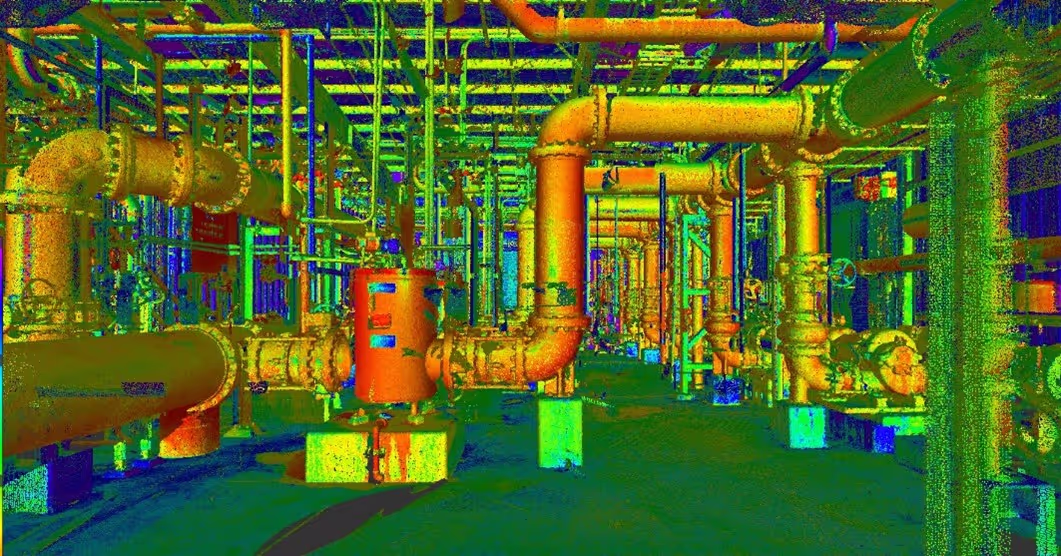
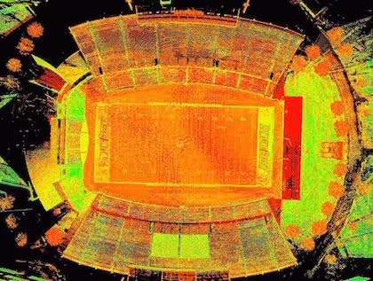
When you need accurate architectural, structural, and MEP system dimensions, locations, and layouts for design, prefabrication, clash detection, facility modifications, or asset management, call GPRS. 3D laser scanning minimizes shutdowns and disruptions, eliminates the need for site revisits, and provides accurate as-built data to reduce risk and increase project efficiency.
A man in a hard hat holding a tablet.

Request A Quote

I am the homeowner on a residential project
Format: 123-456-7890

Project Location

Project Information

To select multiple options, press CTRL

Project Notes *

File Attachments


New Orleans 3D Laser Scanning

504-312-1009laser@gprsinc.com

GPRS Project Managers

GPRS is the leading provider of 3D laser scanning services in Louisiana. Our Project Managers document your site with the Leica ScanStation P-Series and the Leica RTC360 3D laser scanners, capturing up to 2 million data points per second with 2-4 millimeters accuracy. Each Project Manager completes the most extensive training program in the industry, with 80 hours of hands-on classroom training and 320 hours of mentorship in the field, plus another 40 hours of LiDAR training to deliver expertise in 3D laser scanning equipment and field knowledge.

A 3D image of a factory with pipes and valves.A drawing of a road with a red line on it.A 3D drawing of a building with a staircase.

GPRS Mapping & Modeling Team

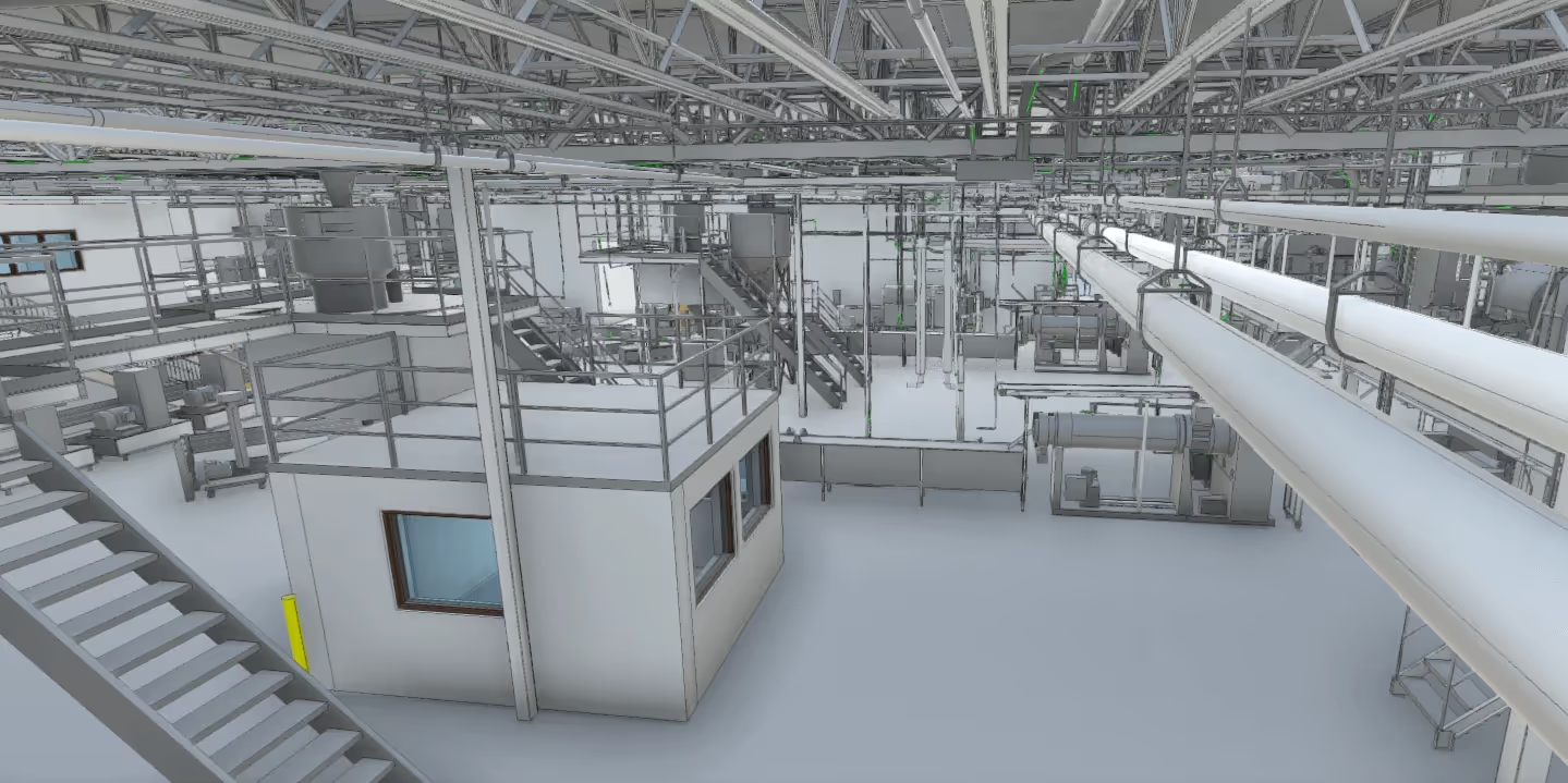
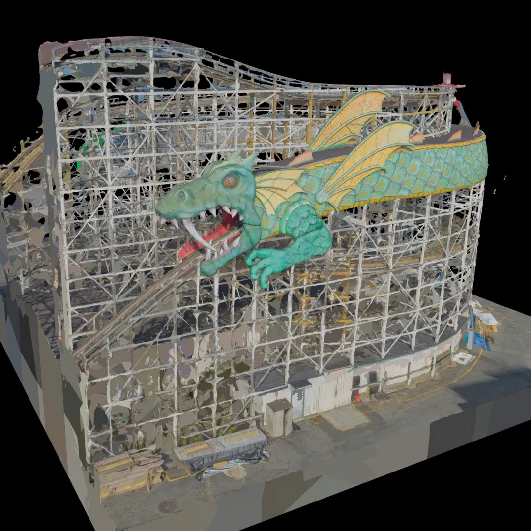
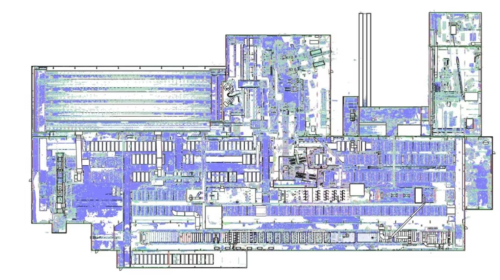
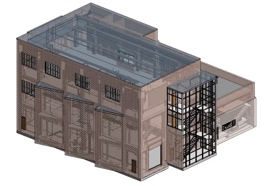
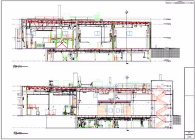
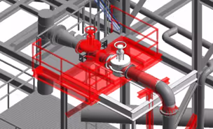
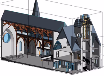
Construction drawings and models streamline planning, visualization, and coordination on your project because they provide a single source of truth for designers, architects, engineers, and contractors. GPRS’ in-house Mapping & Modeling Team can customize as-built data, 2D CAD drawings, 3D BIM models, 3D mesh models, virtual tours via WalkThru 3D, digital twins, floor plans via FLRPLN, and more to ensure you have all the information you need to get the job done right, delivered via GPRS’ SiteMap® digital storage software and app.

Maps and models can be produced at any level of detail in a variety of formats such as Revit, AutoCAD, ReCap, Navisworks, Civil 3D, BIM360, A360, Bentley, Leica Cyclone, Cintoo, and more. We have optimized workflows for importing data, registration, creating deliverables, quality checks, and transferring data to clients.

Not sure what you need? Not a problem. Our experienced Project Managers will work closely with you to define the project scope and use the right equipment and software to accurately map and model your project to accomplish your goals.

WHY CHOOSE US? 

THE GPRS DIFFERENCE.

With GPRS, clients can rest assured that our rigorously trained Project Managers use state-of-the-art technology to deliver the accurate as built information you need to do the job right. GPRS leads the industry to deliver precise as built information to enhance communication and collaboration among your project teams.

GPRS 3D Laser Scanning Services can bring these benefits to your project:

  • Collect up to two million data points per second with the highest-quality survey-grade laser scanners
  • Capture exact dimensions and measurements of your project site
  • Expedite planning and design with accurate as-builts
  • Eliminate site disruption and revisits
  • Receive precise point clouds, 2D drawings, and 3D models to improve collaboration and coordination
  • Tour the location, add digital notes, and even measure with a virtual tour
  • Reduce project risks, change orders, delays, accidents, and costs
GPRS main Logo: Intelligently Visualizing the built world | GPRS

GPRS 3D Laser Scanning Services in Louisiana

A blue and white drawing of a building with a lot of wires.
As-Built Services
As-built services capture exact architectural, structural, and MEP system dimensions and layout of existing buildings, facilities, and sites, making them invaluable for design, construction, renovations, and modifications.
Learn More
A green and blue image of a factory with pipes and valves.
Point Clouds
3D laser scanners record highly accurate digital measurements of sites and assets in the form of a point cloud and can be used to create 2D CAD drawings and 3D BIM models that improve project workflows, shorten turnaround times, and reduce costs.
Learn More
A 3D model of a building with a staircase.
3D BIM Modeling
Intelligent 3D Building Information Models (BIM) provide contractors, engineers, architects, and facility managers an accurate digital twin of buildings and infrastructure to collaborate on design, construction, and operations.
Learn More
A picture of a building with a red circle in the middle.
3D Photogrammetry
3D rendered images can be used to create virtual tours, floorplans, topographic maps, point clouds, 3D models, and more for planning, analysis, and calculations.
Learn More
A drawing of a building with a red roof and a green roof.
2D CAD Drawings
GPRS can translate 3D laser scan data into 2D CAD drawings that provide your team with up-to-date floor plans, elevations, sections, details, isometric drawings, reflected ceiling plans, and more.
Learn More
A red pipe with a blue wire running through it.
Clash Detection
3D laser scanning captures as-built site conditions with 2-4 mm accuracy, helping to identify potential clashes, prefabricate components, and plan a flawless installation.
Learn More
A 3D drawing of a church with a steeple.
Design-Build
3D laser scanning provides accurate as-built site data to prevent expensive rework by identifying any mistakes early in the design through the construction phase.
Learn More
A stadium seating chart with a red line on the field.
Drone Imagery
GPRS offers rectified photogrammetry, aerial video and images, LiDAR scans, 2D orthomosaic images, CAD drawings, 3D models, and 3D fly throughs thanks to a wide-range of drone services operated by FAA Licensed pilots.
Learn More

We provide 3D Laser Scanning Services to these Louisiana counties & many more:

  • East Baton Rouge Parish
  • Jefferson Parish
  • Orleans Parish
  • St. Tammany Parish
  • Lafayette Parish
  • Caddo Parish
  • Calcasieu Parish
  • Ouachita Parish
  • Livingston Parish
  • Tangipahoa Parish

Our portfolio of work includes projects in these Louisiana cities & many more:

  • New Orleans, LA
  • Baton Rouge, LA
  • Shreveport, LA
  • Metairie, LA
  • Lafayette, LA
  • Lake Charles, LA
  • Bossier City, LA
  • Kenner, LA
  • Monroe, LA
  • Alexandria, LA

As-Built Survey Parking Lot Structures for Prefabrication

GPRS provided 3D laser scanning services for six parking lot structures at the Dallas Fort Worth International Airport, ranging from 500 to 2,500 square feet in plan area. The client wanted accurate dimensional information to prefabricate replacement canopies for each of the structures.
GPRS provided 3D laser scanning services for six parking lot structures at the Dallas Fort Worth International Airport, ranging from 500 to 2,500 square feet in plan area
Dallas Fort Worth International Airport – DFW Airport, Texas Prefabrication of Canopies for Parking Lot Structures ‍ TASK: GPRS provided 3D laser scanning services for six parking lot structures at the Dallas Fort Worth International Airport, ranging from 500 to 2,500 square feet in plan area. The client wanted accurate dimensional information to prefabricate replacement canopies for each of the structures. ‍ CHALLENGE: The client needed accurate information to design replacement fabric panels, including the location of the attachment plates and fasteners. They requested a quick turnaround on this project, GPRS expedited deliverables within 15 working days of the purchase order. ‍ SOLUTION: Dimensions were quickly verified in these high traffic areas of the airport with a Leica laser scanner. GPRS’ Mapping & Modeling Team created an LOD 200 Revit 3D model including basic structural elements, such as exposed structural columns and joists, grade and canopy. With the 3D model, the following details could be used to expedite prefabrication and installation - elevations, plan dimensions, radii of rolled elements, plus locations and dimensions of all attachment hardware.
All
3D Laser Scanning
3D Laser Scanning
Mapping & Modeling

GPRS 3D Laser Scans A Massachusetts Library Prior to Renovation

292 individual interior and exterior LiDAR scans were completed in a single day, capturing existing conditions including all historical features, all without disrupting the historic site's operations or impacting its valuable contents so that a renovation could be designed and planned without requiring time consuming hand-measurements.
3D laser scanning a historic Massachusetts library to create a 3D BIM model.
GPRS 3D laser scanned a historic library in Amherst, Massachusetts and created an LOD 300 Revit model for the architect. The interior and exterior of the library was 3D scanned, this was an estimated 47,000 sq. ft. of space with 4 levels.
Built in 1919: there were no existing as-built details availableIt was likely that the existing condition of the building included unsquared architectural features The library’s historic features had to be preserved and intact during and post-renovation The library needed to remain open to patrons and conduct regular operations while visualization was completedPaintings of Emily Dickinson and Robert Frost, plus local historical exhibits, were contained in a gallery on site that needed to remain untouched Laser scanning was executed on Patriot’s Day, a Massachusetts state holiday. The library was closed so all scans could be completed without disrupting operations292 laser scans were completed of the interior and exterior of the library; approximately 47,000 sq. ft. of space spanning four levels An intensity map point cloud and 3D BIM model were delivered to the client, giving them accurate data of the current as-built conditions 3D scanning provided updated floor plans and captured existing conditions via a 3D BIM model to speed redesign and planningArchitects, designers, and contractors could access and utilize the BIM model and 3D laser scanning data at any stage of the restoration process for reference3D laser scanning is non-contact; scanning from a distance minimized the risk of damaging historical art work and exhibits and was completed in a single day on site
All
3D Laser Scanning
3D Laser Scanning

Above & Below-Ground Data Capture for California School's HVAC Upgrades

In less than two hours on site, GPRS 3D Laser Scanning captured all aboveground features and utility field markings that were then used to provide integrated above and below-ground plan view of the campus via 2D CAD drawings to plan HVAC upgrades, and have accurate existing condition documentation for future use
A Los Angeles, California high school required 3D laser scanning of the above ground and below ground infrastructure to create 2D CAD drawings and plan for HVAC system upgrades throughout the campus
In less than two hours on site, GPRS 3D Laser Scanning captured all aboveground features and utility field markings that were then used to provide a integrated above and below-ground plan view of the campus via 2D CAD drawings to plan HVAC upgrades, and have accurate existing condition documentation for future use.
Problem • A 12-year-old high school was replacing the piping on 16 HVAC units throughout the campus. • The piping for these units runs intricately in and out of buildings, and through retaining walls and mechanical yards. • The areas that the pipes thread through do not have any as-builts or existing plans. Solution • Using the Leica RTC360 laser scanner, a Project Manager captured elements of the surrounding campus and GPR markings in less than hours on site • This project was laser scanned in full color, allowing the client to easily visualize and identify structural elements, pipes, conduits, and concrete reinforcement points inside the point cloud • CAD engineers created 2D AutoCAD floor plans and exterior elevations, PDFs with and without the point cloud overlayed Benefits • The combination of laser scanning structural and ground penetrating radar markings provided the client a high definition 3D comprehensive view of the campus, including both visible and invisible elements • With 3D laser scan data, the client can verify the HVAC mechanical equipment with confidence knowing high accuracy instruments minimize position error throughout the 3D space • The client has the most up-to date, accurate and comprehensive information to design HVAC upgrades
All
3D Laser Scanning
3D Laser Scanning
Utility Locating
Mapping & Modeling

GPRS
INTELLIGENTLY VISUALIZING THE BUILT WORLD®