Menu

Location
This is some text inside of a div block.

Utility Locating, Concrete Scanning, 3D Laser Scanning, CAD & BIM, NASSCO-Certified Video Pipe Inspection, and Acoustic Leak Detection Services


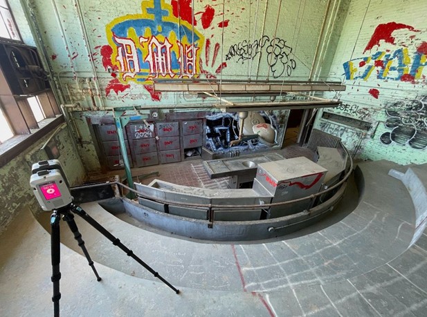
GPRS utilizes a rigorous set of processes and complementary technologies to locate and map underground utilities. The process we use is known as Subsurface Investigation Methodology (SIM) and it is the backbone of our 99.8% accuracy rate in utility locating. Our Project Managers utilize ground penetrating radar (GPR), electromagnetic (EM) locators, and a set of precise, standardized procedures to help you visualize your underground infrastructure. We mark-out various utilities on the surface with spray paint and/or flags, plus map the area utilizing Real-Time Kinematic Positioning, the most accurate satellite geospatial technology available. We deliver CAD, PDF, and .KMZ files, plus interactive digital utility maps, through SiteMap®, our GIS software platform and mobile app.
Utility locating costs vary by project because each site has unique conditions and risks. GPRS provides upfront, project-specific utility locating pricing based on factors such as soil conditions, site size, utility depth, utility density, required level of detail, working hours, and deliverables. Rather than offering a one-size-fits-all rate, GPRS tailors each quote to your exact scope so you only pay for what you need. Accurate, professional utility locating helps prevent strikes, delays, and emergency repairs that can far exceed the cost of our service.
Using GPR technology, GPRS performs concrete scanning to identify the location of rebar, conduit, and post tension cables, assess thickness, and detect potential voids within concrete slabs so you can cut, core, and drill with confidence. GPRS marks findings and verified safe zones directly on the surface of the slab, and we can also build 2D CAD drawings and a 3D BIM model of the interior of your slab. We guarantee our Project Manager’s concrete scanning accuracy through the “Green Box Guarantee”, where any green boxed area placed on concrete is verified clear of obstructions.
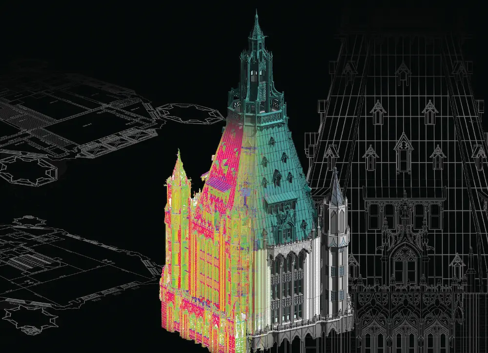
GPRS delivers construction-grade accuracy using high-resolution LiDAR scanners and survey-grade controls and registration. Accuracy depends on site conditions and equipment, but typically achieves tolerances within 2 to 6 millimeters. We deliver point clouds, 2D CAD drawings, and 3D BIM models that give your project team a reliable single source of truth. The result is greater design accuracy, clearer coordination across disciplines, and fewer surprises in the field.
Video pipe inspection is a non-destructive method used to assess the condition of underground piping systems. GPRS deploys robotic crawlers and lateral launch CCTV cameras to document defects, cross bores, and pipe conditions in sanitary, storm, and wastewater systems. We deliver NASSCO compliant inspection reports using WinCan software, including PACP-coded defects and severity ratings to support informed repair decisions.
Acoustic leak detection allows pressurized pipe leaks to be identified before they cause major damage or service interruptions. GPRS leak detection services helps reduce water loss, structural damage, and emergency repair costs. We use advanced acoustic technology to pinpoint leaks accurately, enabling targeted repairs without unnecessary excavation.
SIM certification (Subsurface Investigation Methodology) is a rigorous training program required for GPRS Project Managers to ensure accurate locating, scanning, and data capture above and below ground. The process is built on standardized procedures, safety protocols, and quality controls to ensure consistent, defensible results. Every GPRS Project Manager completes SIM certification, which includes 80 hours of classroom training, 320 hours of field mentorship, and 40 hours of LiDAR instruction.
.svg)