

.svg)
Cross slopes are key for the safety, function, and durability of roads, sidewalks, and paved surfaces. They help manage water runoff, enhance safety, and ensure structural integrity.
Let’s dive into what cross slopes are, why they matter, how they're designed, and the implications of getting them wrong.
What Is a Cross Slope?
A cross slope refers to the transverse gradient of a surface – i.e. the angle or tilt from one side of a pavement or roadway to the other. It is measured perpendicular to the direction of travel and is typically expressed as a percentage or ratio. For example, a cross slope of 2% means the surface drops 2 units vertically for every 100 units horizontally.
Cross slopes facilitate drainage, allowing water to flow off the surface rather than pooling. This is important for roads, where standing water can lead to hydroplaning, damage the pavement, and increase maintenance costs.
Why Cross Slopes Matter
The importance of cross slopes lies in their ability to manage surface water. Water is one of the most damaging elements to paved infrastructure. Without proper drainage, water can infiltrate pavement layers, weaken structural components, and accelerate wear and tear. Cross slopes help mitigate these risks by directing water toward gutters, drains, or adjacent terrain.
Beyond drainage, cross slopes also contribute to:
- Safety: Preventing water accumulation reduces the risk of skidding and hydroplaning for vehicles
- Accessibility: Well-designed cross slopes meet ADA (Americans with Disabilities Act) standards. This makes sidewalks and ramps easier for people with disabilities to navigate.
- Durability: Cross slopes reduce water infiltration, which helps pavements last longer.
Typical Applications of Cross Slopes
Cross slopes are used in a variety of contexts, each with specific design considerations:
Roadways
In road design, engineers apply cross slopes to the travel lanes and shoulders. The slope typically ranges from 1.5% to 2.5%, depending on the type of road and expected traffic volume. Highways often have steeper slopes to drain water quickly. In contrast, urban streets use gentler gradients. This helps balance drainage needs with pedestrian comfort.
Sidewalks and Pedestrian Paths
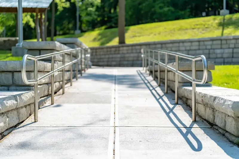
Sidewalks need careful cross slope design to ensure both drainage and accessibility. The ADA sets a maximum cross slope of 2% for pedestrian paths. This rule helps wheelchair users and others with mobility challenges.
Parking Lots
In parking areas, cross slopes direct water toward collection points without creating discomfort for pedestrians or vehicles. The slope must be subtle enough to avoid uneven parking surfaces but steep enough to prevent pooling.
Ramps and Driveways
Ramps, especially those used for accessibility, must balance slope requirements for drainage with strict ADA guidelines. Excessive cross slopes can make navigation difficult or unsafe.
Designing Cross Slopes: Key Considerations
Designing an effective cross slope involves a blend of engineering principles, regulatory compliance, and practical judgment. Several factors influence the ideal slope:
Surface Material
Different paving materials have distinct reactions to water and wear. Asphalt is more flexible, so it can handle slight changes in slope. In contrast, concrete needs precise grading.
Climate and Rainfall
Regions with heavy rainfall demand steeper cross slopes to ensure rapid drainage. Arid areas may prioritize comfort and accessibility over aggressive water management.
Traffic Type and Volume
High-speed roads use steeper slopes to lower the risk of hydroplaning. Low-speed urban streets have gentler gradients to improve pedestrian safety.
Regulatory Standards
Designers must follow local and national standards. These include guidelines from the Federal Highway Administration (FHWA) and the ADA. They outline acceptable slope ranges for various uses.
Measuring and Implementing Cross Slopes
Cross slopes are often measured using surveying tools or digital devices during design and construction. The slope is calculated using the formula:
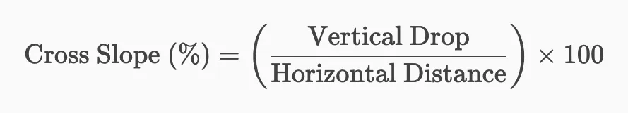
During construction, achieving the correct slope requires precise grading and compaction. Contractors use laser levels, string lines, and automated machinery to ensure consistency across the surface.
Common Challenges and Mistakes
Despite its apparent simplicity, cross slope design can be fraught with challenges. Some common issues include:
Inadequate Slope
A slope that is too shallow may fail to effectively drain water, leading to puddling and long-term damage.
Excessive Slope
Overly steep slopes can create discomfort for drivers and pedestrians and may violate ADA standards.
Uneven Transitions
Bad transitions between slope areas, like from a sidewalk to a ramp, can cause tripping hazards and accessibility issues.
Settlement and Deformation
Pavement can settle or change shape over time due to traffic loads or unstable subgrades. These changes can alter the original slope and affect drainage.
Innovations and Technology in Cross Slope Design
Modern engineering offers various tools and technologies to enhance cross slope design and implementation:
- 3D Modeling and BIM (Building Information Modeling): Allows designers to visualize slope gradients in a digital environment prior to construction.
- Automated Grading Equipment: GPS-guided machinery ensures precise slope creation during paving.
- Smart Sensors: Embedded sensors can track slope integrity, alerting maintenance teams to changes or failures.
Cross Slopes and Sustainability
Sustainable infrastructure design increasingly considers the environmental impact of drainage systems.
Cross slopes play a role in green infrastructure by directing water toward permeable surfaces, bioswales, or rain gardens. This reduces runoff into storm drains and promotes groundwater recharge.
In urban planning, integrating cross slopes with low-impact development (LID) strategies helps cities manage stormwater more effectively while enhancing aesthetics and ecological value.
GPRS offers construction-grade reality capture services to help you inspect ramps and cross slopes. Our laser scanners collect the accurate, actionable data that our in-house Mapping & Modeling Team needs to create floor plans, virtual walkthroughs, BIM models, and whatever other deliverables you need to get the job done right.
What can we help you visualize?
Frequently Asked Questions
How Long Does 3D Laser Scanning Take?
With Project Managers all over the U.S., GPRS works quickly to provide detailed quotes for clients. For most jobs, large areas can be laser scanned in as little as a couple of hours or larger sites in as little as a few days. Entire facilities or campuses can take several weeks to capture the entire site, but most projects are measured in hours or days.
What if My Project is Limited in the Physical Setting?
Some projects require special applications due to limitations within the physical setting. Often times this is due to line-of-sight issues and when a scan must be done safely from the ground or with precautionary distance. Some of these applications would include above-ceiling MEP features in hospitals where it is necessary to maintain negative airflow or interstitial spaces that are congested with limited access. Since laser scanning is a non-contact measurement tool (i.e. we can scan from a safe distance or location) this becomes a powerful tool for solving these complex challenges.