With the millions of data points collected, GPRS’ Mapping & Modeling team could create an accurate LOD 200 Revit 2021 BIM model of this processing facility.
GPRS mobilized to Fairmont, Nebraska to 3D laser scan a food grade corn processing facility. The target objects of point cloud data acquisition were tanks, silos, hoppers, conveyors, support cables, machinery, equipment, cleaning house and loading drive-thru. GPRS’ engineering team created an LOD 200 Revit model of the facility. The client also requested floor flatness analysis/contour mapping around several tanks.
GPRS mobilized to Fairmont, Nebraska to 3D laser scan a food grade corn processing facility. The target objects of point cloud data acquisition were tanks, silos, hoppers, conveyors, support cables, machinery, equipment, cleaning house and loading drive-thru. GPRS’ engineering team created an LOD 200 Revit model of the facility. The client also requested floor flatness analysis/contour mapping around several tanks.
Meta Title: 3D Laser Scanning a Grain Facility Meta Description: GPRS mobilized to Fairmont, Nebraska to 3D laser scan a food grade corn processing facility. Header: A GPRS Case Study: 3D Laser Scanning a Grain Facility Images: Link: https://www.gp-radar.com/services/mapping-modeling
Alt Tag: Point cloud of tank farm at grain facility.
Caption: Point cloud of tank farm at grain facility. Link: https://www.gp-radar.com/services/mapping-modeling
Alt Tag: Point cloud close-up view of catwalks on tanks.
Caption: Point cloud close-up view of catwalks on tanks. Link: https://www.gp-radar.com/services/mapping-modeling
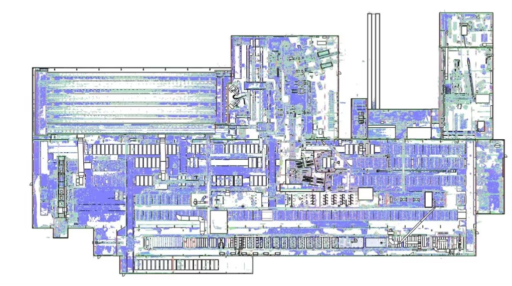
Alt Tag: Point cloud plan view of facility.
Caption: Point cloud plan view of facility. Link:https://www.gp-radar.com/services/mapping-modeling
Alt Tag: Modeled linework plan view of facility.
Caption: Modeled linework plan view of facility. Link: https://www.gp-radar.com/services/mapping-modeling
Alt Tag: 3D Revit model of catwalk area.
Caption: 3D Revit model of catwalk area. Link: https://www.gp-radar.com/services/mapping-modeling
Alt Tag: Point cloud close-up of catwalk.
Caption: Point cloud close-up of catwalk. Link: https://www.gp-radar.com/services/mapping-modeling
Alt Tag: Close-up of discharge area under grain hopper tank.
Caption: Close-up of discharge area under grain hopper tank. Link: https://www.gp-radar.com/services/mapping-modeling
Alt Tag: Point cloud isometric view of food corn processing facility.
Caption: Point cloud isometric view of food corn processing facility. Link: https://www.gp-radar.com/services/mapping-modeling
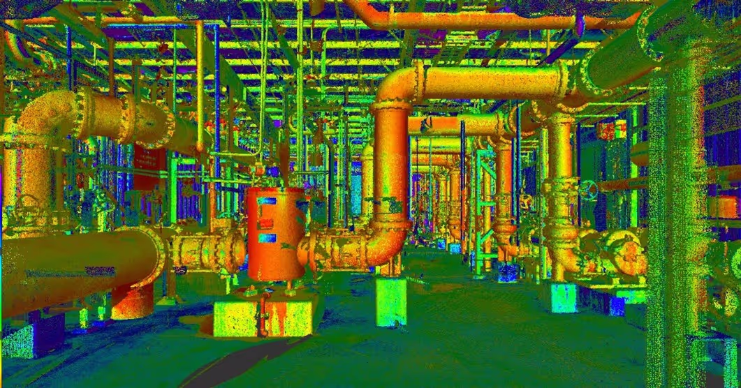
Alt Tag: Point cloud of food corn processing facility.
Caption: Point cloud of food corn processing facility. Link: https://www.gp-radar.com/services/mapping-modeling
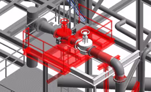
Alt Tag: 3D Revit model of spout and conveyor areas.
Caption: 3D Revit model of spout and conveyor areas. Link: https://www.gp-radar.com/services/mapping-modeling
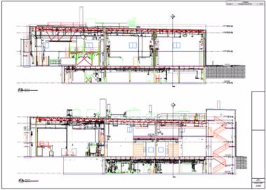
Alt Tag: LOD 200 Revit 3D model of facility in elevation view.
Caption: LOD 200 Revit 3D model of facility in elevation view. Link: https://www.gp-radar.com/services/mapping-modeling
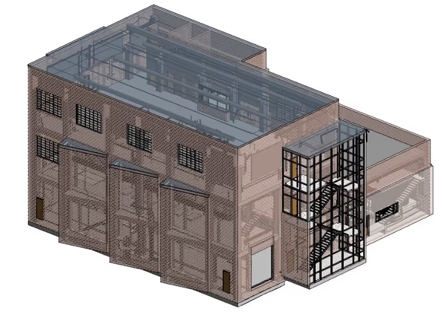
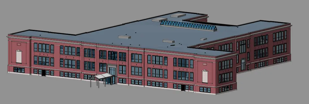
Alt Tag: 3D Revit model of facility.
Caption: 3D Revit model of facility. Link: https://www.gp-radar.com/services/mapping-modeling
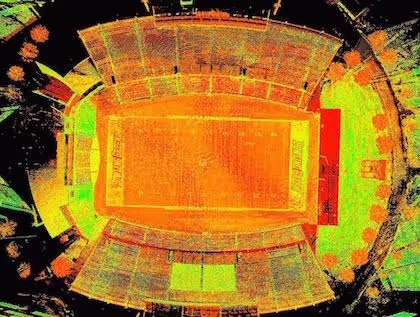
Alt Tag: Tank farm contour mapping plan PDF of tanks.
Caption: Tank farm contour mapping plan of northern tanks. Link: https://www.gp-radar.com/services/mapping-modeling
Alt Tag: Tank farm contour mapping plan PDF of tanks.
Caption: Tank farm contour mapping plan of southern tanks. Location: Fairmont, NE Task: GPRS mobilized to Fairmont, Nebraska to 3D laser scan a food grade corn processing facility. The target objects of point cloud data acquisition were tanks, silos, hoppers, conveyors, support cables, machinery, equipment, cleaning house and loading drive-thru. GPRS’ engineering team created an LOD 200 Revit model of the facility. The client also requested floor flatness analysis/contour mapping around several tanks. Challenge: The client needed accurate and precise detail of the facility in point cloud and model form, especially the congested areas. The client was concerned with differences in tank displacement; therefore, they requested tank farm slab elevation contours. Solution: An experienced project manager captured more than 160 scan locations with a Leica survey-grade laser scanner. The facility was scanned from the ground to capture the tanks, bins, silos, hoppers and discharge area under the 11 hoppers. The facility was 3D laser scanned at elevations with stair and elevator access to capture the spouting and conveyors at the top of each tank, silo and bin. Scanning was completed from the accessible roof to capture the equipment, cables and machinery present. The cleaning house was also scanned at multiple elevations to capture the entire room. The project manager increased the resolution and density of the point cloud to capture more detail in congested areas with small conduits, piping and flanges. With the millions of data points collected, GPRS’ engineering team could model this project with accuracy and precision. Concrete slab flatness can be quickly analyzed with laser scanning. GPRS engineers colored the cloud in respect to elevation to illustrate high or low points in the concrete. Deliverables: GPRS delivered unified point clouds in PTS file format, structured individual scans in E57 file format, a colorized point cloud (.rcs and/or .rcp file format) and JetStream Viewer files to the client. An LOD 200 Revit 2021 BIM model was created with the following elements: • Basic structural elements including exposed columns and beams
• The general shape of 6 tanks with high detail at discharge locations and high detail on gates to conveyors
• Rail spur within vicinity of tanks
• Catwalks and equipment on tanks
• Fall protection
• Edge of adjacent building
• Approximate grade GPRS delivered a graphical elevation map, contours and spot elevations for the requested tanks. This included AutoCAD, PDF, and Civil 3D files to generate contours around the tank farm. Added Value: GPRS works closely with each client to ensure their needs are met. Point cloud files were immediately uploaded to Cintoo for the client’s use. They were able to add annotations or tags to anything they might want modeled. To minimize modeling costs, all modeling is done as a “best fit” method, utilizing solids overlaid on the point cloud data. To verify the spot elevations, GPRS also provided tank roof elevations shown colored by point cloud elevation.
All
3D Laser Scanning


.svg)

.avif)
.avif)
.avif)