

.svg)
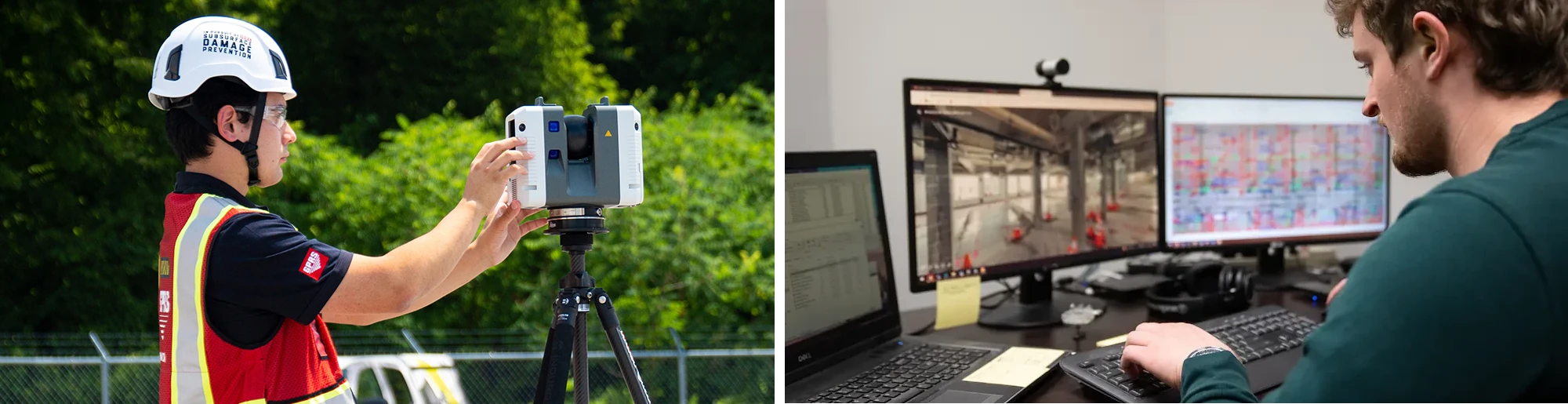
Scan to BIM is a cutting-edge reality capture process that transforms real-world buildings and infrastructure into intelligent digital models. It begins with 3D laser scanning, where millions of data points are captured to create a highly accurate point cloud of a site.
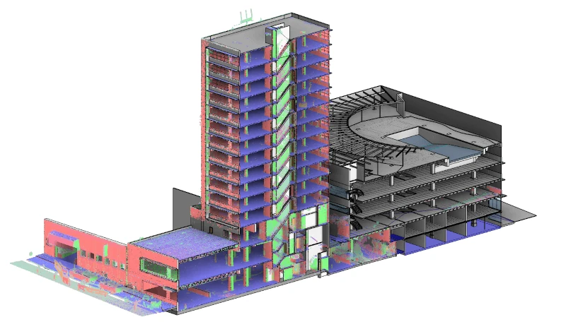
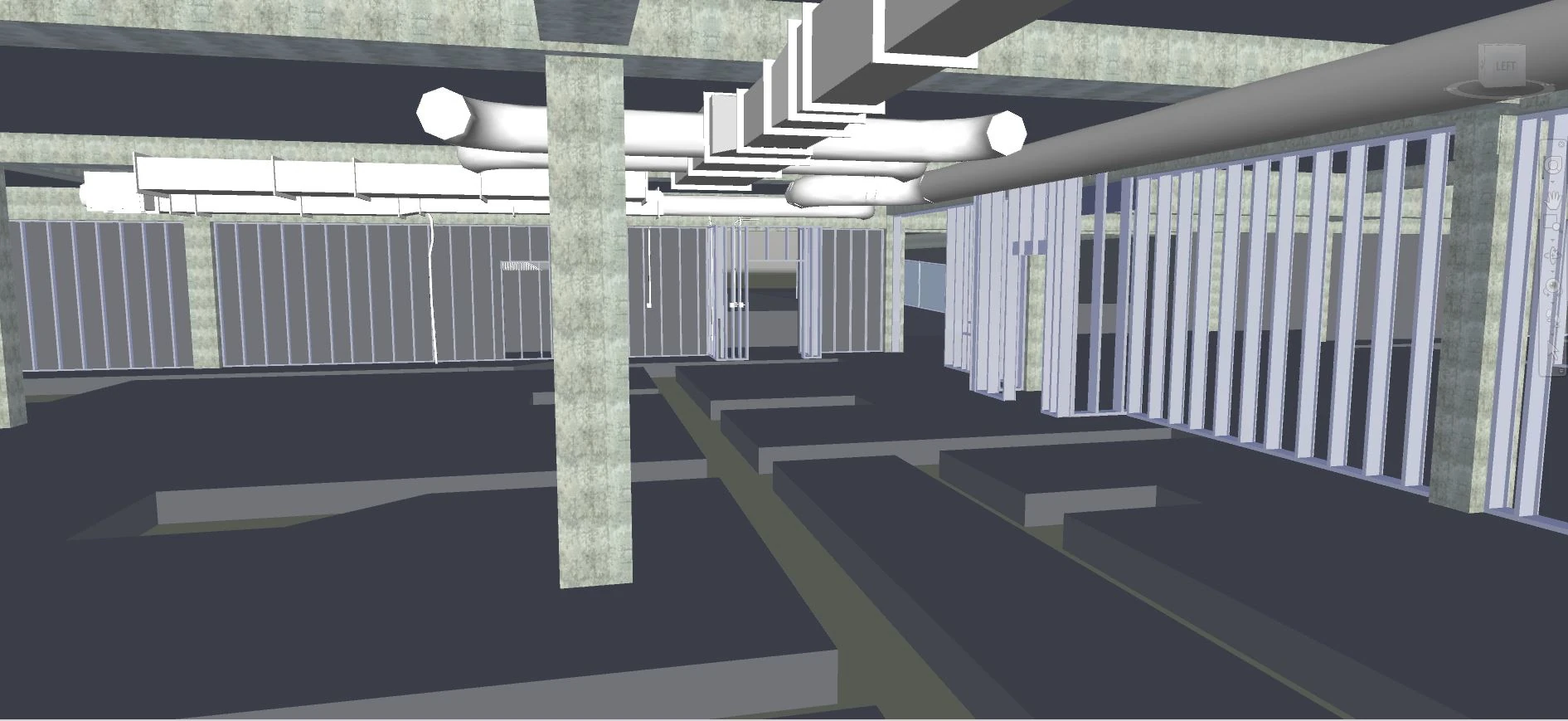
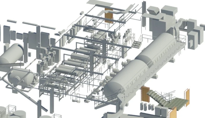
The point cloud is converted into a building information model (BIM), a data-rich, 3D representation that includes architectural, structural, mechanical, electrical, and plumbing (MEP) systems. Other scan to BIM deliverables can be created, such as 2D CADD drawings, 3D mesh models, TruViews, and virtual tours in formats like Revit, AutoCAD, Navisworks, Civil 3D, and more.
“Scan to BIM transforms real-world conditions into accurate digital models: this streamlines design, reduces rework, and improves coordination from start to finish on any project,” says Tyler Zak, Market Segment Leader – GPRS Reality Capture Services.
What are the Benefits of Scan to BIM?
Scan to BIM improves how architects, engineers, and contractors plan, renovate, and manage buildings. Scan to BIM provides these benefits:
- Captures precise site conditions with millimeter-level accuracy, minimizing measurement errors and guesswork
- Accelerates data collection and reduces manual work, helping shorten timelines and reduce project costs
- Collects millions of data points in minutes to streamline workflows and speed up project delivery
- Aligns teams in a shared digital model, ensuring consistency and coordination
- Detects design clashes early to prevent rework, delays, and on-site conflicts
- Documents historic buildings for restoration without damaging original features
- Supports long-term facility management for maintenance, upgrades, and renovations
- Serves as the building block to your digital twins
These benefits make scan to BIM a powerful tool for AEC professionals. As noted in a recent Research Gate article, titled BIM and Automation in Complex Building Assessment, “using Building Information Modeling (BIM) during early design stages helps improve building quality by enabling the evaluation of different design options and structural systems.”
Whether you're renovating a courthouse, expanding a manufacturing plant, or retrofitting a stadium, scan to BIM provides the foundation for intelligent design planning and construction execution.
How Much Does Scan to BIM Cost?
The cost of scan to BIM can vary depending on your project. First, project size and scope play a major role. Larger buildings require more time to scan and process, and sites with multiple floors, complex MEP systems, or multiple roof sections typically increase the overall cost due to the added intricacy and data volume.
The second factor is whether your project requires greyscale or colorized 3D laser scanning. Colorized scanning typically requires approximately three times longer to perform than standard greyscale scans, which impacts time in the field and ultimately increases cost.
The third factor is the level of detail (LOD) specified for the deliverables. LOD 100 to 200 models provide basic mass and geometry and tend to be more affordable. LOD 300 includes structural and architectural elements, falling into a mid-range price bracket. LOD 400 to 500 delivers highly detailed BIM models with full mechanical, electrical, and plumbing (MEP) integration and are higher in cost.
Structural complexity is another important consideration. Simple warehouses or open layouts are less expensive to model compared to ornate historic buildings or facilities packed with dense MEP systems, which demand greater scanning resolution and scan to BIM modeling effort.
Site accessibility can also influence pricing. Remote or hard-to-reach locations might require specialized equipment or incur travel expenses, both of which add to the project total.
Another critical factor to keep in mind is whether we’ll be working within a modeling template you provide. Following a predefined template and standards can take a bit more time to model, which can increase the overall cost.
Lastly, the type and quantity of deliverables required determine the final budget. Basic point cloud data is the most cost-effective option, while 3D BIM models and 2D CADD drawings increase the cost. It's also important to note that we can always add additional elements to your model later on as your requirements evolve. Below is a list of common scan to BIM deliverables.
What are the Types of Scan to BIM Deliverables?
Scan to BIM deliverables are the outputs generated from converting laser scanned point cloud data into usable digital formats for design, construction, and facility management.
Point Cloud Files: Raw 3D data captured from laser scans, typically in formats like .rcp, .e57, or .las. These serve as the foundation for the deliverables mentioned below.
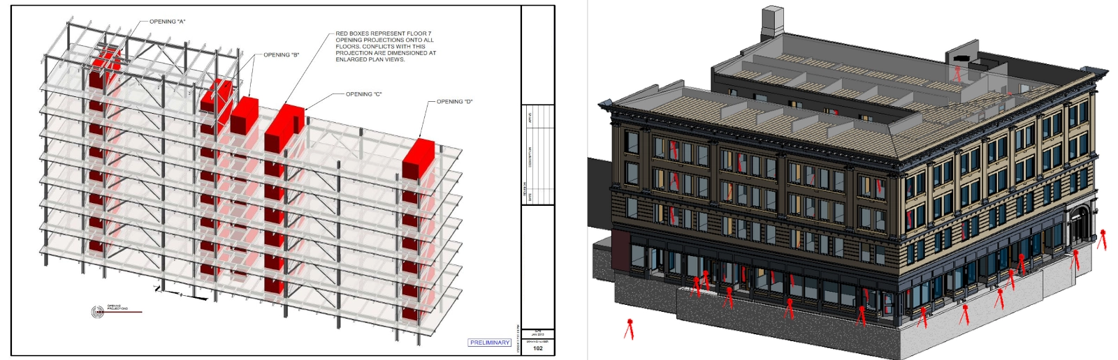
2D CADD Drawings: Floor plans, elevations, sections, details, isometric drawings, and reflected ceiling plans (RCPs) extracted from the point cloud, delivered in .dwg, .dxf, .dgn, or .PDF formats.
3D BIM Models: Intelligent models built in software like Revit, AutoCAD, Microstation, Solidworks, Navisworks, representing architectural, structural, and MEP systems.
Mesh Models: Polygonal representations of surfaces, useful for visualization or simulation, often exported in .obj, .stl, .fbx, and .ply.
TruViews: Interactive, 360° photo-realistic views linked to laser scan data, allowing users to navigate the site virtually.
Virtual Tours: A collection of panoramic rotating images, stitched together to form a full, 360° view of a location.
BOMA-Compliant Lease Plans & Area Analysis: Accurate measurements of usable and rentable space that support leasing, property valuation, and compliance delivered in .dwg and .pdf formats.
Does GPRS Perform Scan to BIM Services?
GPRS is a national leader in 3D laser scanning and reality capture services, using construction-grade LiDAR-based 3D laser scanners to perform scan to BIM with exceptional precision. Our CADD/BIM Team delivers a full suite of deliverables that are produced in-house to ensure technical accuracy and consistency across platforms.
Here is a list of items a GPRS Project Manager will use to determine the cost of your scan to BIM project.
- Location
- Scope of work
- Square footage
- Site images
- Site plans
- Building or site complexity
- Number of rooms
- Building or site access and occupancy
- Equipment selected
- Greyscale or color scanning
- Deliverables required
- Accuracy and level of detail (if CADD drawings or 3D modeling are needed)
- Project timeline
- Special requirements, such as night or weekend scanning
Every project is unique. That’s why GPRS tailors our scope of work to meet the specific demands of each project – to ensure you get exactly what you need, with deliverables customized to your specifications. Our expert team can model within your template and to your standards, and will adhere to naming conventions, on request.
For scan to BIM pricing, request a quote here, call 419-843-7226, or email Laser@gprsinc.com.
GPRS Scan to BIM Project Examples
Scan to BIM for Renovations at Arizona University Laboratory Building
A general contractor was tasked with renovating four laboratory rooms at an Arizona university, totaling 19,000 square feet. To ensure a seamless renovation process, the team required a precise 3D Revit model, detailing the locations of structural elements, HVAC systems, and piping.
- Captured the as-built locations of structural components, HVAC equipment, and piping systems
- Performed 97 terrestrial laser scans in one day
- Delivered a point cloud, 2D CADD drawings, 3D Revit model, and a TruView virtual tour to support renovation planning
Pharmaceutical Upgrades Completed with the Help of Laser Scanning
GPRS used 3D laser scanning to capture existing conditions across four levels of a pharmaceutical facility undergoing equipment upgrades and MEP rerouting. By delivering a precise LOD 300 Revit model, the client was able to plan layout changes, avoid field rework, and reduce downtime, resulting in faster execution and significant cost savings.
- Documented structural elements, MEP piping and equipment, conduit, and ductwork across four levels of the facility
- Produced an LOD 300 Revit model with 72,000 linear feet of pipe, 75,000 linear feet of conduit, and 11,000 linear feet of duct
- Supplied accurate existing conditions documentation for equipment placement, MEP rerouting, tie-in coordination, and accelerated return to production
Why Choose GPRS for Scan to BIM Services?

GPRS is a leading scan to BIM service company, having completed thousands of projects across sectors including healthcare, education, manufacturing, and government.
Offering nationwide coverage and fast turnaround times, our team delivers consistent, construction-grade results. Each Reality Capture Project Manager completes the industry-leading Subsurface Investigation Methodology (SIM) certification, which includes 80 hours of classroom training, 320 hours of field mentorship, and 40 hours of specialized LiDAR instruction, ensuring expertise in 3D laser scanning and field accuracy that exceeds industry standards.
GPRS scan to BIM deliverables are uploaded to SiteMap®, GPRS’ secure GIS platform, giving clients 24/7 access to verified as-built documentation in one centralized location to help you plan, build, and manage better.
Learn more about the SiteMap Reality Capture Layer, here.
Tyler Zak, Market Segment Leader – GPRS Reality Capture Services says, “With GPRS, you receive more than a scan, you gain a precise digital foundation to drive project success.”
What can we help you visualize?
Frequently Asked Questions
What is Level of Detail (LOD)?
Level of Detail (LOD) is the defined degree of geometric accuracy and information included in a BIM model. For scan to BIM projects, LOD typically ranges from LOD 100–200 for basic massing and geometry to LOD 300 for coordinated architectural and structural elements, and up to LOD 400-500 for highly detailed models with full MEP integration. GPRS' 3D laser scanning and BIM modeling services are tailored to your required LOD, so your team receives the right level of detail for design, coordination, prefabrication, renovation, or facility management.
See how GPRS helped an engineering firm replace outdated, fragmented water treatment facility as-builts with 20 discipline-specific LOD 350 Revit models, giving the team accurate, design-ready existing conditions to plan major process upgrades at the facility, here.
How accurate is GPRS' 3D Laser Scanning?
GPRS' 3D laser scanning is within 2-4mm accuracy, and our CADD/BIM Team delivers construction-grade as-built documentation at 2-6 mm accuracy. Using advanced LiDAR-based 3D laser scanners, we capture millions of 3D points in seconds to create millimeter-accurate point clouds of:
- Construction Sites
- Architecture, Adaptive Reuse
- Historic Buildings, Museums, Churches & Monuments
- Agricultural Facilities
- Industrial, Manufacturing & Distribution Facilities
- Office Buildings & Commercial Buildings
- Oil & Gas Facilities
- Power Plants & Process Plants
- Real Estate
- Recreation, Retail & Restaurant Locations
- Energy & Utilities
- Stadiums, Arenas, Theaters & Convention Centers
- Telecommunication Sites
- Government, Defense & Military Sites
- Schools & Universities
- Hospitals, Healthcare & Pharmaceutical Facilities
- Subsurface Utility & Concrete Markings
- HVAC & MEP (Mechanical, Electrical, and Plumbing) Features
- Water & Wastewater Treatment Plants
- Accident Sites & Incident Scenes
- 3D Tree Architecture
- Residential Properties, Homes & Apartments
- Infrastructure Projects, Bridges, Tunnels, Airports
GPRS' CADD/BIM Team transforms point cloud data into 2D CADD drawings, 3D BIM models, and other reality capture deliverables that help architects, engineers, and contractors plan, build, and manage with confidence.
See how GPRS completed 1,680 laser scans of a 250,000-square-foot historic building and delivered point cloud files, a 3D Revit model, and TruViews to help the project architect design the renovation with a high level of detail and confidence, here.
Why is scan to BIM important for renovation and retrofit projects?
Scan to BIM is important for renovation and retrofit projects because it gives teams an accurate digital representation of existing conditions before design and construction begin. This is especially valuable in older or complex buildings, where hidden conflicts, undocumented changes, and dense structural or MEP systems can lead to costly rework, delays, and coordination issues. GPRS' 3D laser scanning, point cloud data, and BIM modeling deliverables, such as Revit models, 2D CADD drawings, and TruViews, help project teams plan renovations with confidence.
Click here to learn how GPRS provided a detailed 3D BIM model of a 300,000-square-foot building conversion so the contractor could accurately plan the retrofit, coordinate MEP upgrades, and reduce the risk of rework during fit-out.
How long does a scan to BIM project take?
The timeline for a scan to BIM project depends on the site size, building complexity, required level of detail, whether we need to work within your template and naming conventions, and final deliverables. While 3D laser scanning can capture millions of data points in minutes, overall turnaround is influenced by factors such as multi-floor capture, dense MEP systems, occupied conditions, and whether the project requires point clouds only, 2D drawings, or full BIM modeling. GPRS helps keep projects moving with Project Managers "boots on the ground," nationwide, flexible scheduling, including night or weekend scanning, and in-house modeling workflows that accelerate delivery without sacrificing accuracy.
Learn more about how much space can be 3D laser scanned in one day, here.
By Jen Britt and Amanda Zaslow, GPRS, updated 2026.
Jen Britt is a content and technical writer who has been covering the U.S. reality capture and AEC industries for 10 years. She has been writing for GPRS since 2022.
Amanda Zaslow is a content and technical writer who has been covering the U.S. reality capture and AEC industries for 4 years. She has been writing for GPRS since 2024.