

.svg)
Reality capture is a powerful tool used across the construction, architecture, and engineering industries. At GPRS, we hear from clients who want to gain a deeper understanding of the technology, its applications, and how it fits into their projects. That’s why we’ve compiled answers to the most commonly asked questions about 3D laser scanning, LiDAR, BIM, digital twins, and more. Whether you’re a beginner or want to expand its use, you'll find explanations to make informed decisions.
WHAT IS LIDAR?
LiDAR (Light Detection and Ranging) is a remote sensing tool that builds accurate 3D models of objects and surfaces. Instead of using radio waves like radar, LiDAR sends out laser pulses from a scanner. These light pulses bounce off objects, and the system measures how long they take to return. This helps calculate exact distances and shapes. It creates detailed three-dimensional data about an object.
WHAT IS THE DIFFERENCE BETWEEN LIDAR (TIME-OF-FLIGHT) AND PHASE-BASED SCANNING?
LiDAR systems operate using the time-of-flight method. This approach involves emitting short laser pulses toward a beam, then measuring the time it takes for the reflected signal to return. Using the known speed of light, we calculate the distance to the object as:
Distance = (Speed of Light × Time of Flight) / 2.
Time-of-flight LiDAR works well for long-range measurements. But it generally gathers data at a slower rate than phase-based systems.
Phase-based laser scanners work by sending out a steady laser beam modulated in many phases. The system measures distance by looking at the phase difference between emitted and reflected signals. It uses this formula:
Distance = Phase Shift / (2π × Modulation Frequency).
This method allows for faster data capture but has a limited range compared to time-of-flight systems. Phase-based scanning tends to have more “noise” or false data compared to time-of-flight scanners.
WHAT IS 3D LASER SCANNING?
3D laser scanning uses LiDAR to measure precise distances and locations. It creates a point cloud file, which is a digital map made of millions of points. This helps you get accurate measurements and images of buildings in a short period of time. 3D laser scanning is a modern tool to document existing conditions. This supports your work in design, construction, prefabrication, facility changes, and asset management.
WHAT IS REALITY CAPTURE, EXACTLY?
Reality capture utilizes tools like 3D laser scanning and photogrammetry. These tools create a precise digital record of existing conditions.
HOW DOES GPRS CONDUCT REALITY CAPTURE SERVICES?
GPRS captures millions of precise data points at any site to document existing conditions in detail. We process this data into point clouds. Then, it transforms into 2D CAD drawings or 3D BIM models, depending on the client’s needs. This enables accurate planning and easy coordination across all disciplines.
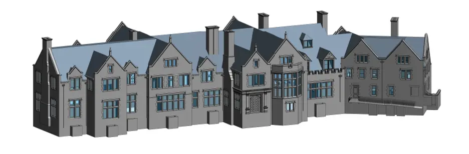
WHAT IS A BIM OR A 3D BIM MODEL?
A Building Information Model (BIM) is a digital representation of a facility’s physical and functional characteristics.
WHAT IS A DIGITAL TWIN?
A digital twin is a complex virtual model. It serves as the exact twin (counterpart) of a physical object. GPRS uses 3D laser scanners to collect real-time data, which helps create a digital twin of a building or facility. You can easily visualize, measure, and analyze data. Digital twins can also be used to improve efficiencies, optimize workflows, and detect problems before they occur.
ARE REALITY CAPTURE AND A DIGITAL TWIN THE SAME THING?
Reality capture is the process of collecting spatial data from the physical world. A digital twin is a dynamic, data-rich virtual model of a physical asset. It integrates real-time information and analytics.
Reality capture provides the geometric foundation for building a digital twin. GPRS delivers both, tailored to your project’s needs.
WHAT IS AS-BUILT DOCUMENTATION?
As-built 3D documentation is a clear and accurate set of drawings that show how a project was actually built.
HOW ACCURATE IS GPRS REALITY CAPTURE?
GPRS delivers construction-grade precision through high-resolution LiDAR scanning. This is in combination with survey-grade control and registration techniques. Accuracy depends on site conditions and equipment. Our usual tolerances are between 2 and 6 millimeters. This accuracy is more than sufficient for clash detection, prefabrication, and as-built documentation.
WHAT IS 3D PHOTOGRAMMETRY?
3D photogrammetry reconstructs three-dimensional models by analyzing overlapping photographs captured from various angles. Using computer vision algorithms, it triangulates spatial coordinates. This is also known as orthomosaic imaging and registration. It helps to generate 3D meshes, point clouds, or virtual walkthroughs for visualization and measurement.
WHAT IS ARTIFICIAL INTELLIGENCE (AI) AND MACHINE LEARNING IN RELATION TO LASER SCANNING?
If you use laser scanning in your workflow, CAD technicians will turn your point cloud data into useful drawings or models. Many software tools help by automatically sorting and cleaning the data. In this field, that process is often called “artificial intelligence” or “machine learning.” AI’s software makes decisions or classifications that are usually done by humans. Machine learning is when software improves at tasks by practicing. It relies on human input and training.
CAN YOU USE WORKSETS?
Yes, we can use worksets and attach different components based on what the client prefers. According to Autodesk, “a workset is a collection of elements in a workshared project.’
CAN YOU TIE THE POINT CLOUD DATA TO LAND SURVEY CONTROL?
GPRS does not perform land surveys or Subsurface Utility Engineering (SUE) surveys. However, we support your survey team by providing high-quality SUE Level B mapping and utility locating services. When we use LiDAR-based 3D laser scanning, you can expect accuracy between 2 and 6 millimeters. If you provide proper documentation, including the location and coordinates (x, y, z) of control points, we can attach point cloud data to survey control.
DO WE NEED TO PLACE TARGETS DURING 3D LASER SCANNING?
Targets – black and white markers placed on tripods, are sometimes used to help align scan data. We place these at known control points and scan them to help the software match and correct the data. GPRS mainly uses scanners that don’t need targets. But we do use them in certain cases:
- Survey Control: When linking scans to client-provided survey data.
- Multiple Scanners: When combining data from different scanners, targets help align multiple datasets.
Targets align scan data with control points or global coordinates. They also help ensure the precise registration of data from multiple 3D laser scanners.
CAN YOU USE MY REVIT TEMPLATE AND FAMILIES?
Before the GPRS Reality Capture Team issues a project proposal, our consultative sales team will confirm whether your deliverables need to be developed within a specific Revit template. The GPRS Mapping & Modeling Team can work within client-provided templates. This ensures that your project can proceed immediately upon delivery of the 3D BIM model. Make sure we receive your Revit template before modeling begins.
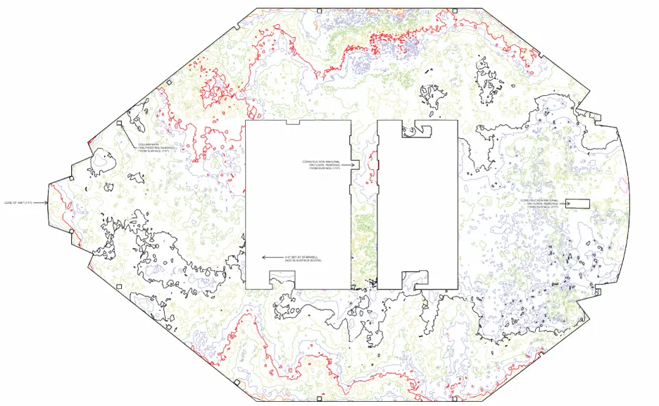
CAN YOU DETECT IF MY FLOOR IS UNEVEN?
Floor deformation mapping is a service we provide to determine the levelness of the floor using a “topographic-like" 2D CAD file. The 2D CAD file is then merged within the Revit model.
CAN YOU MODEL THE SIDEWALKS AND THE SITE?
Modeling sites is possible if it is within the scope of work. This can include components like sidewalks, ramps, stairs, and parking lots. It’s best to discuss these in the early project phase to include them in the scope of work. Sometimes a client may only want to model just the sidewalk. Or sometimes the client wants the sidewalk and parking areas to be modeled. We can model a site, but the word "site" is too broad. We will need to get specific about what the client wants modeled.
CAN YOU EXPORT A REVIT FILE TO MY PREFERRED FORMAT?
All GPRS’s modeling takes place within Revit. We can export our models into various formats like DWG, DXF, DGN, SAT, PLN, OBJ, and PDF. These are all file types supported by Revit.
CAN I SHARE PROJECT FILES WITH MY TEAM?
Upon delivery by the GPRS Mapping & Modeling Team, the model belongs to the client. They have rights to share or distribute it as they wish.
IS THERE A SOFTWARE THAT DOES ALL THE MODELING FOR YOU?
At present, no software exists that can provide models with complete accuracy. The GPRS Mapping & Modeling Team models each wall, floor, door, and window with precision.
CONSIDERING PURCHASING A LIDAR SYSTEM?
When buying a laser scanner, the cost isn’t just the price of the machine. You also need to pay for qualified personnel, special software, training programs, scanner calibration, and even legal fees. Before you buy, make sure you understand the real cost of owning a scanner. Often, hiring a qualified professional can save you money and ensure the job is done right.
WHAT IS THE COST OF LASER SCANNING VS. THE COST OF TRADITIONAL MEANS TO “AS-BUILT” ON A SITE?
Weighing the benefits of laser scanning versus using traditional means to “as-built” a site:
- Safer – No need for lifts, harnesses, or other high-risk equipment
- Faster – The process requires fewer people and allows scanning of a larger area in less time
- Lower Costs – Reduces extra site visits for missed measurements
- Saves Time – You focus on what you do best, while scanning happens on-site
- Cost Savings – Cuts travel expenses, lift rentals, and errors from manual measurements
- Streamlines Workflow – Deliverables are ready for immediate use, speeding up your project start
WHAT ARE YOUR NAICS CODES, SIC CODES, CSI CODES, PSC, AND FSC CODES?
GPRS Reality Capture Services fall into the following categories:
NAICS Codes:
- 541370 Surveying and Mapping
- 541330 Engineering Services
- 541340 Drafting Services
- 541690 Other Scientific and Technical Consulting Services
SIC Codes:
- 87130000 Surveying Service
CSI Codes:
- 2073 3D Laser Scanning and Dimensional Survey
PSC and FSC Codes:
- C217 Mapping
- C218 Architectural and Engineering Services
- 1550 Drones
- 6675 Drafting, Surveying, and Mapping Instruments
- R425 Engineering and Technical Services
- R617 Data Collection Services
WHAT IS THE DIFFERENCE BETWEEN A “DESIGN INTENT” AND “AS-BUILT MODEL?”
- DESIGN INTENT – these models align with standard design practices. A few examples include walls positioned at 90° to floors, straight pipes and conduits, and level floors and ceilings. This approach produces cleaner 2D drawings and simplifies dimensioning. It does not exactly follow the scan data, but is ideal for most clients who need standard deliverables.
- AS-BUILTS – deliverables will match actual site conditions with a high degree of accuracy. This creates a true reality-capture representation. If walls lean, pipes sag, floors slope, or steel shows camber, these issues will show up in the model. Dimensioning can also be more challenging because elements are not perfectly level or plumb. Leverage this option when the exact conditions of the scan area are critical. Clients utilizing the data for fabrication, forensic analysis, bolt hole patterns, camber/sag/deformation analysis, and similar needs would need this option.
WHAT CAD AND BIM SOFTWARE DOES GPRS USE?
Our engineers and CAD technicians are trained in the following software:
- Autodesk Recap
- Autodesk Revit
- Autodesk 3DS Max
- Autodesk Navisworks
- Autodesk AutoCADCivil 3D
- Autodesk AutoCAD Map 3D
- Autodesk BIM 360
- Autodesk A360
- Autodesk Recap
- AutoCAD
- ArchiCAD
- Bentley MicroStation
- Bentley Descrates V8i
- ClearEdge 3D Edgewise
- Leica Cyclone
- FARO As-Built
- FARO Scene
- Scene 2go
- Scene Webshare
- AVEVA LFM
- Cintoo
- CloudCompare
- Unreal Engine
- FileZilla
- ShareFile
- Dropbox
- Register 360
- JetStream Viewer
- TruView
WHAT IF MY PROJECT IS LIMITED WITHIN THE PHYSICAL SETTING?
Certain projects need specialized scanning approaches due to physical constraints. These limits often arise from obstructed lines of sight or the need to scan from secure, ground-level spots. Laser scanning has a clear advantage. It’s a non-contact method, so it captures data from a safe distance. This way, it doesn’t disturb sensitive areas.
Examples include above-ceiling mechanical, electrical, and plumbing (MEP) systems in healthcare facilities. Here, keeping negative airflow is crucial.
Another example is interstitial spaces that are packed tightly and hard to reach. In these cases, laser scanning reliably provides accurate spatial data and minimizes disruption.
WHAT IS SLAM?
SLAM (Simultaneous Localization and Mapping) is a computational method used to navigate and digitally reconstruct a physical environment. Its core function is to determine the scanner’s position relative to its surroundings (localization). It also concurrently generates a spatial map of the area (mapping).
WHAT ARE THE BENEFITS OF 3D LASER SCANNING?
- Millions of real-world data points – A single laser captures up to one million 3D data points every second. This allows for detailed and thorough documentation of physical environments.
- Eliminate error – Manual tools like tape measures or handheld devices can lead to human error. Laser scanning provides sub-centimeter accuracy. This makes it the most reliable way to capture dimensional data.
- Answers unanticipated questions – Laser scanning gathers extensive spatial data in one site visit. This lowers the chances of missing measurements. It also cuts out extra trips to collect more data.
- Reduce change orders and waste – Using laser scan data in design ensures accurate spatial coordination. This minimizes construction conflicts, cuts change orders, and reduces unnecessary material use.
- Minimize shutdown times – Laser scanning is quick, safe, and non-intrusive. It eliminates and minimizes operational shutdowns and client inconvenience.
- Increase safety – The scanning is quick and non-invasive. It can occur without disrupting ongoing operations. Thus, scanning minimizes downtime and client inconvenience.
IS 3D LASER SCANNING RIGHT FOR MY PROJECT?
Almost any project that needs as-built information benefits from 3D laser scanning. Talk with our experts and begin your existing conditions survey today.
WHAT INDUSTRIES DOES GPRS SERVE?
GPRS provides reliable 3D laser scanning and modeling services. We service hundreds of clients across various industries. Our team focuses on accuracy, professionalism, and strong client service. We collaborate with each client to deliver detailed point clouds, 2D CAD drawings, and 3D BIM models.
Our scanning services are designed to support a wide range of industries, offering clear and accurate digital models that help you plan, build, and manage better. We offer 3D laser scanning services to the following industries:
- Agricultural Facilities
- Architectural Documentation
- Concrete Construction
- Construction
- Clash Detection
- Design Build
- Energy & Utilities
- Engineering
- Government, Defense & Military Sector
- Healthcare & Pharmaceutical
- Historical Documentation & Preservation
- HVAC & MEP Coordination
- Industrial, Manufacturing, Assembly & Distribution Facilities
- Mixed Reality & 3D Projection Mapping
- Office & Commercial Buildings
- Overhead Clearances
- Oil & Gas Facilities
- Power Plants & Process Plants
- Real Estate
- Stadiums, Arenas & Theatres
- Telecommunications
- Schools & Universities
- Subsurface Utility Engineering
- Virtual Design and Construction
- Water & Wastewater Treatment Plant
- Accident Reconstruction
- 3D Video Gaming & Software Development
IS GPRS AN EXPERIENCED COMPANY?
GPRS is a highly experienced provider of 3D laser scanning services. We have completed scanning and modeling projects across many industries. Our teams can deploy quickly to any location in the United States. GPRS has worked with some of the top leading firms to scan industrial plants, oil and gas sites, historic buildings, stadiums, hospitals, universities, municipal facilities, wastewater treatment plants, new construction projects, and more.
We are a licensed engineering firm that focuses entirely on 3D laser scanning. GPRS uses in-house technicians and engineers to provide a detailed review of site conditions. Then they create customized deliverables such as point clouds, 2D CAD drawings, and 3D BIM models tailored to the client’s needs.
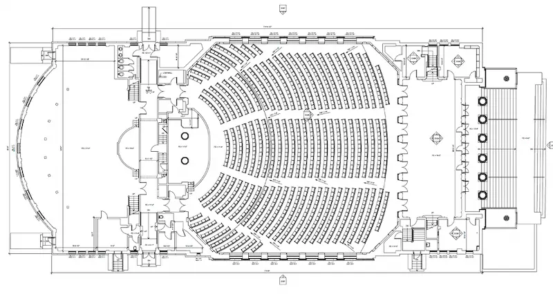
WHAT DELIVERABLES CAN GPRS PROVIDE?
We can deliver 3D laser scan data in many formats, including:
- Point Cloud Data (Raw Data)
- 2D CAD Drawings
- 3D Non-Intelligent Models
- 3D BIM Models
- TruView (previously known as JetStream) Viewer
CUSTOMIZABLE DELIVERABLES UPON REQUEST
- Aerial Photogrammetry
- Comparative Analysis
- Deformation Analysis
- Digital Drawings of GPR Markings
- Floor Flatness Analysis/Contour Mapping
- New Construction Accuracy Analysis/Comparative Analysis
- Point Cloud Modeling Training Webinars
- Reconciliation of Clients 2D Design Drawings
- Reconciliation of Clients 3D Design Model
- Structural Steel Shape Probability Analysis
- Template Modeling
- Volume Calculations
- Wall Plumb Analysis
IS NATIONWIDE SERVICE AVAILABLE?
GPRS serves a diverse client base, ranging from small firms to multinational corporations. GPRS is ready to mobilize to any site in the United States, typically within the lead time of 24-48 hours. Additionally, we can be on-site, short-term or long-term, based on our clients' specifications.
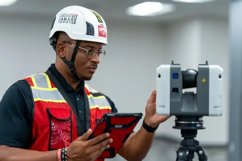
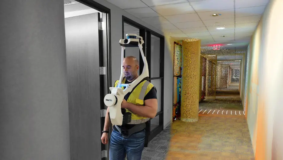
WHAT IS HIGH-DEFINITION SCANNING?
GPRS uses construction-grade 3D laser scanners. These tools collect accurate data in many environments, including buildings, hospitals, schools, and industrial sites. This technology works well on structures of any size or surface feature. We can quickly scan large areas and deliver detailed 3D models. These scans help document current conditions. They also aid in planning renovations and checking construction progress to match the design.
WHY IS A POINT CLOUD IMPORTANT?
Point clouds are a key source of spatial data for many projects. They store millions of coordinates. Users can extract large datasets for information.
HOW LONG DOES 3D LASER SCANNING TAKE?
GPRS has Project Managers across the country, allowing us to respond quickly with detailed quotes. Most jobs can be scanned in just a few hours, while larger sites may take a few days. Scanning entire facilities or campuses can take weeks. Yet, most projects are complete in hours or days.
HOW IS 3D LASER SCAN DATA REGISTERED?
The registration process is a collaborative effort. Registering a 3D laser scan point cloud involves aligning multiple scans of the same area taken from different positions into a single, coherent point cloud. This typically involves using specialized software like Autodesk Recap to import the data and align the scans. The Mapping & Modeling Team uses the software to spot overlapping areas in different scans. It captures the same physical features from slightly different angles. This helps the software identify corresponding points.
Unwanted “noise” can be cleaned or deleted from the point cloud. Autodesk Recap software can remove unwanted data or noise. This includes reflections, moving objects, and background clutter. As a result, it creates a clean point cloud that shows the target project area. Proper registration makes sure 3D laser scan measurements are accurate. This data can be exported for use in CAD or BIM software like Revit or AutoCAD.
HOW IS 3D LASER SCAN DATA PROCESSED?
Once a site is scanned, we process the raw point cloud data by combining individual scans. We remove unwanted noise and convert the data into usable formats like 2D drawings or 3D models. The level of detail depends on the project’s needs, ranging from basic visuals to complex models. GPRS follows a structured workflow focused on accuracy, teamwork, and planning. We ensure efficient project execution. Our deliverables are high-quality and tailored to each client's needs.
WHY WORK WITH GPRS?
Many of our clients are new to laser scanning, so we guide them through every step, from pre-planning to final deliverables. This hands-on support is one reason we’ve earned the trust of top companies and institutions across the country.
We understand you have choices: buying or renting equipment, or hiring another provider. But GPRS offers key advantages that set us apart:
- Cutting-edge technology – GPRS utilizes the most up-to-date technology, equipment, and software.
- Industry trends – Laser scanning is a fast-changing field. Since it’s our main focus, we stay current with new methods and tools, so you don’t have to.
- Training – GPRS technicians receive formal training from the scanner manufacturer. They also get thorough coaching from a seasoned in-house technician. Furthermore, because our team of professionals is committed entirely to scanning and processing the data, we have developed the steps to work quickly, accurately, and knowledgeably.
- Expertise – Our GPRS team brings combined expertise to every project in multiple disciplines, including engineering, architecture, information technology, and construction. This knowledge combination helps us give our clients excellent service and top-quality deliverables.
- Professional support – While our field team handles scanning, our office team is ready to answer questions and help when needed.
- Client-focused approach – We listen carefully to your goals and often suggest ideas to add value to our service.
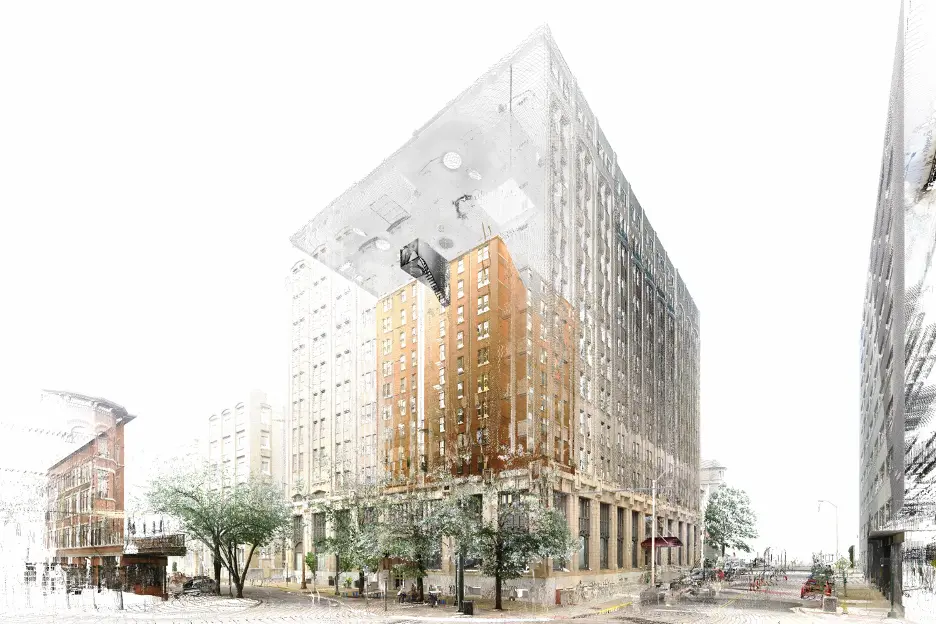
GPRS 3D REALITY CAPTURE SERVICES
GPRS is a leading 3D laser scanning company in the United States, helping clients to successfully complete their most complex architecture, engineering, and construction projects. We've been providing reality capture services and excellent customer service for over two decades.
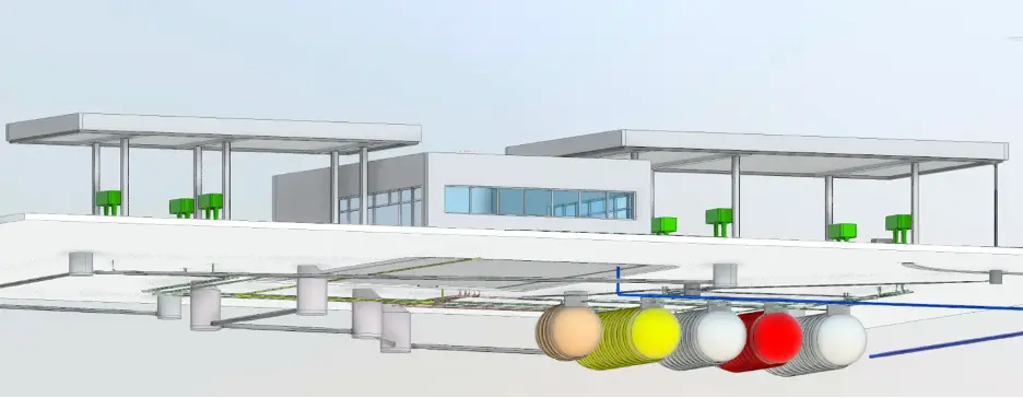
GPRS’s elite team of Project Managers efficiently 3D laser scans the exterior and interior of each site with professional-grade laser scanners, capturing the exact layout, dimensions, and locations of your specific project requirements. This includes architectural, structural, and MEP features, walls, windows, doors, stairs, roof, railings, exposed columns, beams, equipment, piping, ducts, and more.
Our Mapping & Modeling Team registers and processes the point cloud, removing noise and setting the coordinate system to provide the most precise measurements. Data is then compiled into custom 2D CAD drawings and 3D BIM models and delivered via SiteMap®. SiteMap is GPRS’ secure GIS platform that delivers point cloud data, 2D CAD drawings, and 3D BIM models, giving clients 24/7 access to verified as-built documentation to help start accurate and stay accurate.