

.svg)
A Sitemap® Personal Subscription Is Available At Zero Cost To GPRS Customers
Did you know that GPRS has created a first-of-its-kind utility and infrastructure data visualization platform, and we’re giving it away to our customers?
It is true. If you are an existing GPRS customer, you can now access your interactive, layered utility maps, concrete imaging data, NASSCO-certified video pipe inspection reports, 3D point clouds, maps & models, and more inside one secure, easy-to-use, and shareable platform. It’s called SiteMap® (patent pending) because just like GPRS, it visualizes and delivers your above and below ground infrastructure to let you Intelligently Visualize The Built World® to keep your projects on time, on budget, and safe.
SiteMap® redefines collaboration for your project, your facility, your campus, or your distributed assets throughout the United States. Because you can access SiteMap® from anywhere, 24/7, via your computer or mobile device.
How Comprehensive Data Control Helps Mitigate Risk On Your Jobsite
SiteMap® is designed to give you complete data control because when you control your data, you can control damage. SiteMap® can help you avoid
- Utility strikes
- Change orders
- Reworks
- Delays
- Cost overruns
- Injuries
Because it creates a single source of truth for your project and your team, and lets you decide what data you share, who you share it with, and for how long, to streamline communications, eliminate information bottlenecks, and keep everyone on the same page…
Whether you’re managing one project or an expansive distributed portfolio.
How Does Sitemap® Work?
The most important feature of the SiteMap® platform is that it is simple to use. The user interface is built to be intuitive and to get you the information you need as quickly and painlessly as possible.
You can access your job information from the Map Viewer, where you can choose any site GPRS has visualized for you and drill down into your layered utility maps, real-time photos of your concrete mark-outs, and data provided by any other applicable GPRS services.
In most cases your utility data is available in as little as five minutes because that’s how committed we are to making sure you have comprehensive, accurate data and complete data control.
When you access your data in SiteMap®, your utility maps are laid over your site’s satellite or drone imagery, giving you a realistic visualization of what’s under your roads, buildings, and facilities.

Plus, it’s color-coded just like your physical mark-outs on site, and digitally layered, so you can toggle layers on or off at will to see and share only the data that’s needed to do the job instead of expecting subcontractors and tradespeople to wade through the complex schematics of a blueprint.
You can also choose to share VPI reports, leak information, 3D walkthroughs, BIM models, and more, all from one secure and simple-to-use platform.
What Are The Various SiteMap® Subscription Levels And How Do You Access Your Complimentary Account?
There are four distinct subscription levels for SiteMap®. As an existing GPRS customer, you automatically receive a complimentary SiteMap® Personal subscription to view, access, and share your secure jobsite data.
To access your complimentary SiteMap® Personal account, you just need to follow the steps below:
- Visit our website at sitemap.com
- Select the LOGIN button
- Set up your account with your email address & password and access your data.
If your email address is associated with any GPRS data in SiteMap®, your jobs will populate in the Map Viewer and you can access them immediately.

If you encounter any issues with accessing SiteMap® or your jobsite data, you can contact your SiteMap® Support Team directly and they’ll walk you through it. We also provide helpful video explainers to answer most of your questions.
The other subscription levels available are SiteMap® Project, SiteMap® Pro, and SiteMap® Team.

Each tier provides distinct, customizable tools designed to meet your specific workflow requirements and organizational needs. You can learn more about these subscriptions by scheduling a personalized demonstration of SiteMap®, here.
What Is The Quality Of Data In Sitemap®?
SiteMap® is populated with the 99.8%+ accurate utility locating and concrete scanning data, millimeter-accurate 3D laser scans, drawings, maps, and models, 3D photogrammetry, leak detection & NASSCO-certified interactive video pipe inspection reporting you have come to expect from GPRS, which is what sets it apart from other GIS platforms.
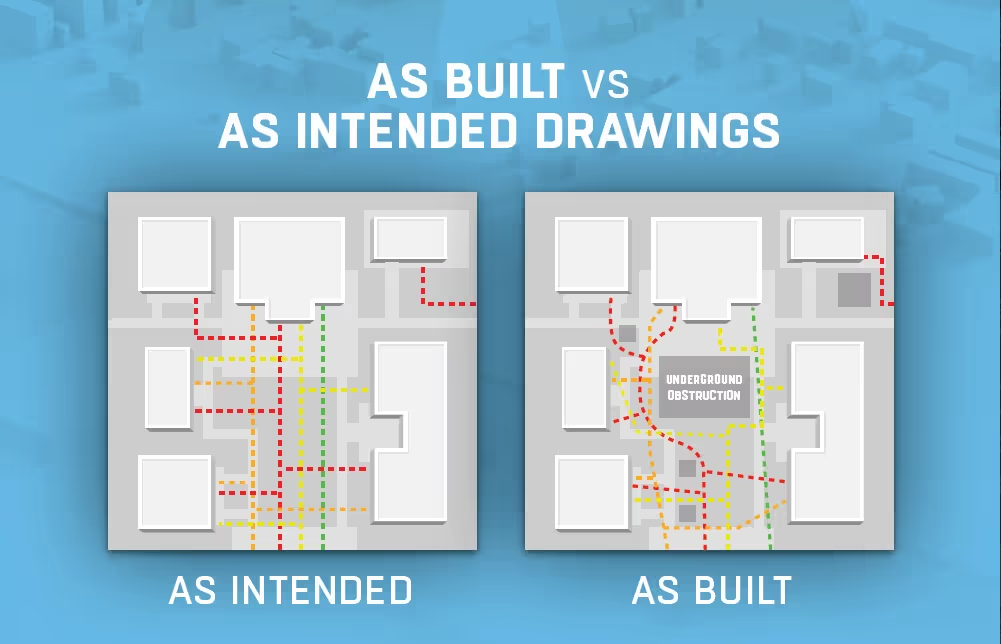
GIS tools are only as good as the existing as built data you put into them. And as you know, most record drawings and as builts are outdated, inaccurate, or non-existent, especially when it comes to your utilities and underground infrastructure. At best, your paper plans are “as intended” rather than as built, and that inaccurate data is the cause of the vast majority of jobsite damages and put your team at risk.
What Is The GPRS Difference?
SiteMap® relies on GPRS’ expert “boots on the ground” – our 500 Project Managers who are stationed nationwide – to provide rapid response service, usually within 24-48 hours, no matter where you need us.
Every GPRS Project Manager adheres to the most rigorous non-destructive testing and locating standards in the industry thanks to our use of Subsurface Investigation Methodology, or SIM.
To become SIM Level 101-certified, a Project Manager must complete a minimum of 80 hours of classroom training and 320 hours of mentored field training. Every GPRS Project Manager is certified at SIM 101 or higher, creating an elite strike force of infrastructure visualization experts. So, whether you are in Anchorage, Alaska or Miami, Florida – or anywhere in between – you can rest assured that there’s a SIM-certified utility, concrete, 3D laser, VPI, and leak detection professional near you, and that the data collected in SiteMap® meets our rigorous quality standards.
GPRS Helps You Intelligently Visualize The Built World®
GPRS has spent the last several years and millions of dollars developing SiteMap® to provide our customers with a cloud-based software platform that includes everything you love about GIS systems, with none of the learning curve or stress, plus GPRS’ outstanding infrastructure and 99.8%+ accurate utility mapping capabilities.