

.svg)
Documenting existing conditions is just the beginning of a project’s lifecycle. With reality capture, teams gain a foundation for data‑driven decisions that guide design, construction, and long‑term facility management. The precise data generated through 3D laser scanning reduces risk, improves collaboration, and safeguards investments. Reality capture can protect against litigation, provide clear visualization of concrete floor contours, track construction progress, and model both above‑ and below ground infrastructure.
In this article, we’ll explore each of these uses in more detail and share case study examples that demonstrate how reality capture delivers measurable value to real projects. These applications for reality capture give project teams accurate, defensible records and a single source of truth, helping them plan smarter, collaborate more effectively, and deliver projects with confidence.
1. Reality Capture for Litigation Protection
Before and After Scanning of the Buildings Next to a Construction Site
Reality capture can play a critical role in supporting and preventing litigation by documenting the condition of buildings adjacent to a construction site. By performing 3D laser scanning both before and after construction activities, clients can capture precise digital records of exterior and interior details. These scans create indisputable evidence of a structure’s existing conditions, helping to resolve disputes over damage claims and protect contractors, owners, and stakeholders from costly legal challenges.
3D laser scan data can be delivered in formats such as point clouds, CAD, or BIM. With accurate, time-stamped data, project teams gain peace of mind knowing they have defensible documentation to safeguard against litigation.
Case Study: 101 Federal Street – Pre-Construction 3D Laser Scan Survey

Project Background
101 Federal Street is a 381-foot tall, 31-story-high rise located in Boston’s financial district. Completed in 1988 by the architectural firm Kohn Pedersen Fox Associates, the tower is a prominent fixture in the city’s skyline. When a neighboring parking garage was demolished to make way for a new mixed-use tower of similar size, the proximity of the new construction, just 10 feet from 101 Federal Street, raised concerns about potential structural impacts.
Challenge
To assess and identify any damage from this nearby construction project, the building owners, at the request of their insurance company, requested the completion of a pre-construction 3D laser scan survey. Traditional inspection methods lacked the precision and defensibility required to stand up in potential legal disputes.
Solution
A comprehensive 3D laser scan survey was conducted to reality capture every exterior and interior detail of 101 Federal Street prior to the start of construction. This high-resolution digital documentation created an indisputable record of pre-existing conditions, ensuring that any future claims of damage could be evaluated against precise baseline data.
Benefits
- Defensible Documentation: The scan provided time-stamped, verifiable records that could be used in litigation or insurance claims.
- Risk Mitigation: Owners and insurers gained peace of mind knowing they had objective evidence of the building’s condition.
- Collaboration Support: Architects, engineers, and contractors can reference the digital model to understand site constraints and protect the existing structure.
- Future Asset: Beyond litigation protection, the digital as-built serves as a valuable resource for ongoing maintenance and future renovations.
By leveraging 3D laser scanning, the owners of 101 Federal Street safeguarded their investment against potential disputes arising from nearby construction. Pre-construction reality capture established a clear, defensible baseline of the building’s condition, demonstrating how reality capture technology can serve as both a risk management tool and a long-term asset for property owners.
2. Concrete Floor Contouring
Clear Visualization of Floor Elevations and Levelness
Concrete floor contouring provides a clear visualization of floor elevations and levelness, by mapping the surface exactly as it exists. Floor contouring utilizes reality capture technology to generate a digital map of a floor’s elevation profile. 3D laser scanning and photogrammetry records millimeter-accurate data, capturing millions of data points across the slab. This provides far more comprehensive coverage than traditional sampling methods, which might only measure every 10 feet.
Contour maps are typically presented in color-coded formats; for example black, white, and red contour lines, to highlight major elevations, making measurements easy to interpret. For floors with significant undulation, additional detail can be provided through heat map overlays, offering a more intuitive view of elevation changes. Results can be exported as 2D CAD drawings, BIM models, or detailed reports. These visualizations make it easy to identify high and low points, undulations, and general slope patterns.
Floor contours help project teams understand site conditions, anticipate challenges, and make informed decisions during construction and renovation. Unlike a flatness analysis, which compares slope and levelness against client-specified tolerances, contouring simply records the actual surface conditions. Contouring does not determine whether the floor meets industry standards (ASTM, ADA, AISC) for flatness or levelness. That requires a structural engineer’s analysis and certification.
Case Study: Floor Contours for Accurate Concrete Documentation
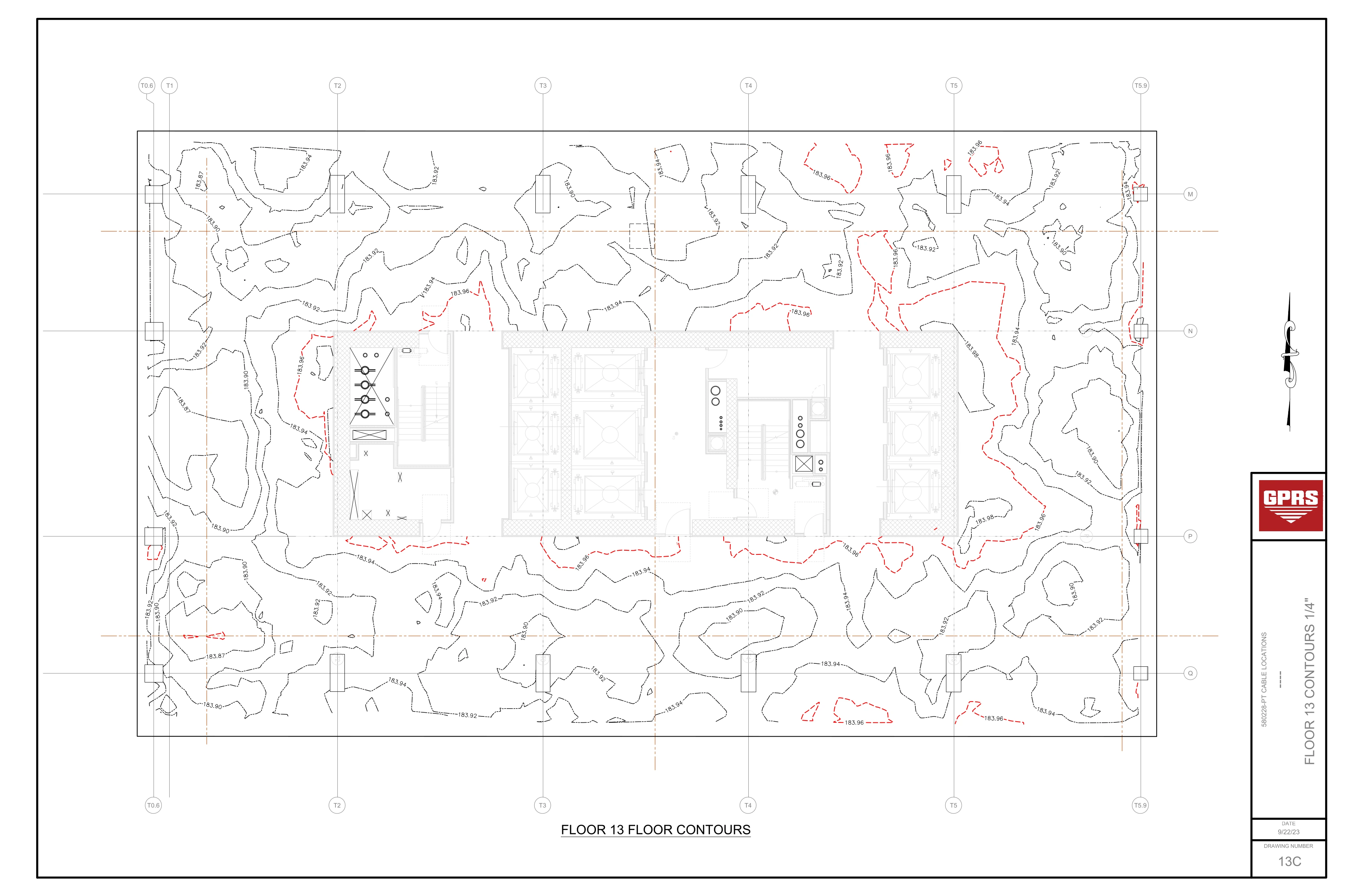
Project Background
A 49-story high-rise construction project in Detroit, Michigan required precise documentation of concrete slab conditions on floors 12 through 23 to support the safe installation of MEP and HVAC systems. In addition to mapping post tension cable layouts, the project team needed detailed records of slab elevations to ensure accuracy for design and construction coordination. To achieve this, 3D laser scanning was performed across each of the 12 floors, covering approximately 12,500 square feet per level, capturing the PT cable layout and floor contours with high precision.
Challenge
Concrete slabs often exhibit undulations, slopes, and elevation changes that can affect the installation of MEP equipment, finishes, and structural systems. Traditional measurement methods provide limited sampling and can miss localized variations. The client required a comprehensive record of floor contours to understand the true levelness of each slab and to prevent costly clashes or rework.
Solution
GPRS deployed 3D laser scanning technology to capture millions of data points across each floor with 2–4mm accuracy. The laser scan point cloud data was transformed into 2D floor contour maps documenting the actual floor elevation. Data was integrated into CAD and BIM deliverables, providing the client with an intuitive understanding of slab elevations and depth of cover.
Benefits
- Comprehensive Coverage: Full floor contour maps documented actual elevations across 12,500 square feet per floor.
- Enhanced Visualization: Color contour lines and heat maps made elevation changes easy to interpret.
- Risk Reduction: Accurate elevation records helped prevent clashes, change orders, and delays.
- Integration: Deliverables aligned to survey control and client design models, ensuring seamless collaboration.
GPRS delivered precise floor contours and slab elevations that improved collaboration and reduced risk across the project. The combination of 3D laser scanning, CAD drawings, and BIM models provided the team with a clear record of concrete floor conditions, supporting safe construction practices and informed decision-making throughout the project.
3. Progressive Site Capture
Understand Progress on a Construction Site
Reality capture technology documents every phase of construction with 3D photogrammetry, capturing precise details such as concrete reinforcements before pours, MEP installation locations, and more. By scanning the site regularly, clients can track its evolution, monitor milestones, and ensure work stays on schedule.
These scans can be performed on a customized schedule, bi-weekly, monthly, or tailored to client needs, to record every critical milestone in a project’s lifecycle. Accurate site records help prevent clashes, reduce change orders, and streamline communication.
Progressive capture is especially valuable for managing projects remotely or overseeing multiple sites. Digital as-builts can be delivered via GPRS SiteMap® GIS Platform (patent pending) and can be downloaded, saved, and shared across laptops, tablets, or smartphones—accessible anytime, anywhere.
Case Study: Riverside Labs – Reality Capture for Mechanical Coordination
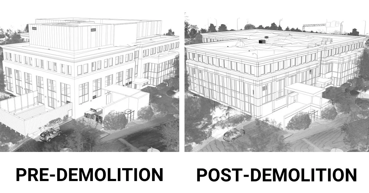
Project Background
Riverside Labs, a high tech laboratory facility undergoing transformation into a premier life sciences campus, required precise documentation to support complex mechanical coordination. Shawmut Construction & Design and its partners needed to ensure that demolition and reconstruction activities proceeded according to plan, with critical infrastructure installed to specifications before being enclosed.
Challenge
Managing construction in a high-tech lab environment presents unique challenges. Mechanical, electrical, and plumbing (MEP) systems, clean rooms, utilities, and specialized infrastructure must be coordinated with extreme accuracy. The client needed to verify exposed element, including MEP lines and structural components, post-demolition, while maintaining confidence that construction milestones were achieved on time and on budget.
Solution
GPRS performed comprehensive 3D laser scanning, creating 2D CAD drawings, 3D Revit models, and MEP/FP documentation, both before and after demolition. Pre-demolition documentation established a clear baseline of existing conditions, ensuring future construction proceeded smoothly. Post-demolition scans provided Shawmut and its subcontractors with precise records to guide mechanical installation and coordination. These deliverables were accessible remotely via SiteMap, enabling Shawmut Construction & Design to monitor progress and resolve issues without being on site.
Benefits
- Remote Oversight: Project teams can review progress and address challenges from any location.
- Construction Verification: Confirmed that MEP systems, cleanroom infrastructure, and specialized utilities were installed to specifications before enclosure.
- Risk Reduction: Accurate records minimized change orders and delays.
- Collaboration Support: 2D CAD drawings, 3D Revit models, and MEP/FP documentation improved communication between contractors, engineers, and owners.
- On Time, On Budget Delivery: Reality capture ensured Riverside Labs’ transformation was completed efficiently and safely.
Through pre- and post-demolition reality capture, Shawmut Construction & Design and its partners coordinated complex mechanical systems with confidence. The use of 3D laser scanning created 2D CAD drawings, 3D Revit models, and MEP/FP system documentation to streamline collaboration, ensuring Riverside Labs’ redevelopment into a premier life sciences campus was delivered on time, on budget, and safe.
4. Above and Below Ground Infrastructure Modeling
Record Comprehensive Infrastructure Documentation
3D laser scanning provides comprehensive documentation once utility locating and concrete scanning are complete, capturing a precise digital record of both above ground and subsurface conditions. After utilities are flagged and concrete elements are marked, laser scanning creates a high resolution point cloud that captures the exact layout of architectural features, structural features, MEP systems, utility locations, and concrete field markings.
This documentation can be transformed into CAD drawings, BIM models, and 3D virtual tours, giving project teams clear, accessible records that integrates seamlessly into design and construction workflows. Clients can extract 3D coordinates, take distance measurements, and view location details to more effectively communicate with the project team. With 3D laser scanning, stakeholders gain access to structural and subsurface conditions, for accurate planning, reducing risk, avoiding costly rework, and increasing efficiency throughout the project lifecycle.
Case Study: BIM Model Aids Stadium Renovations
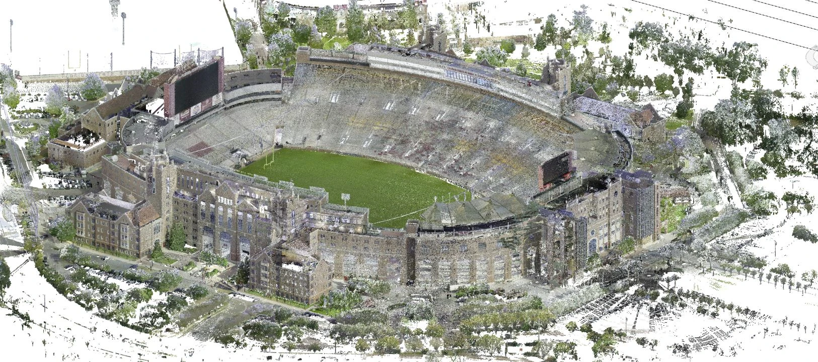
Project Background
Florida State University’s Doak Campbell Stadium in Tallahassee required extensive renovations as part of a $255 million project to update seating with founders' boxes and a field level club. The scale of the facility, over 600,000 square feet of interior space and two acres of subsurface utilities—demanded precise documentation to support design changes, material selection, cost estimation, and construction phasing.
Challenge
Renovating a stadium of this size presented multiple challenges. The client needed accurate as built documentation of both above ground and below ground conditions to avoid costly mistakes. On a college campus, a utility strike could disrupt classes, extracurricular activities, and even endanger lives. Additionally, the complexity of the renovation required a single source of truth where architects and engineers could access the latest site data and coordinate updates seamlessly.
Solution
GPRS deployed LiDAR laser scanners to capture detailed dimensions and layouts of the architectural, structural, and MEP systems on the 600,000-square-foot facility with 2–4 mm precision. Ground penetrating radar (GPR) and electromagnetic locating equipment were used to identify and mark underground utilities, including fire water mains, sanitary sewers, storm sewers, and power lines. The Mapping & Modeling team converted this data into utility maps and a 3D BIM model, delivered in Revit and ArchiCAD formats. These models contained both 3D design elements (walls, columns) and 2D drafting elements (dimensions, labels), providing a comprehensive digital representation of the stadium.
Benefits
- Accurate Utility Maps: Prevented accidental damage during excavation and enhanced on-site safety.
- Comprehensive BIM Model: Allowed architects to plan renovations precisely, reducing change orders and saving time.
- Collaboration Support: Technical construction drawings (floor plans, elevations, cross sections) were easily generated and shared across disciplines.
- 24/7 Access via SiteMap®: All as-built data was uploaded into GPRS’ GIS-based platform, enabling mobile access and eliminating information silos.
- Informed Decision Making: Stakeholders can visualize complex design updates and coordinate confidently across project teams.
By combining utility locating with 3D laser scanning, GPRS delivered a comprehensive BIM model that streamlined stadium renovations. The integration of above- and below ground data into SiteMap® provided architects and contractors with a single, accessible source of truth—ensuring the $255 million renovation of Doak Campbell Stadium was designed right the first time, completed safely, and executed efficiently.
Let GPRS 3D Laser Scanning Help You Visualize The Built World®
Reality capture is more than existing conditions documentation; it is a strategic resource that empowers owners, contractors, and designers to make informed decisions, avoid costly errors, and protect investments. Whether used to document pre-existing conditions, visualize slab elevations, monitor construction milestones, or integrate subsurface data into BIM models, reality capture delivers clarity and certainty. By adopting these practices, project teams gain a single source of truth that drives efficiency, reduces risk, and ensures successful outcomes from planning through completion.
GPRS 3D Laser Scanning Services provide 2-4mm accuracy by capturing 2 million data points per second for efficient planning, design, and construction. Our in-house Mapping & Modeling Team can export your GPR utility locates & concrete scans, 3D laser and photogrammetry data, and video pipe inspection reports to create accurate existing condition as-builts, above and below ground, to give you the accurate information you need in a format you can easily work with and share to keep your project on time, on budget, and safe.
Frequently Asked Questions
What is reality capture and how does it differ from traditional documentation methods?
Reality capture uses 3D laser scanning and photogrammetry to create precise digital records of existing conditions. Unlike traditional methods that rely on limited sampling or manual measurements, reality capture captures millions of data points with millimeter accuracy, providing comprehensive, defensible documentation that can be transformed into CAD drawings, BIM models, and 3D visualizations.
How can reality capture help reduce risk on construction projects?
By documenting site conditions before, during, and after construction, reality capture provides indisputable records that safeguard against litigation, prevent utility strikes, and reduce costly rework. Accurate data helps project teams anticipate challenges, avoid clashes, and make informed decisions, ultimately lowering risk and improving efficiency across the project lifecycle.