

.svg)
What Are the Key Considerations Before Deciding on 3D Laser Scanning Services?
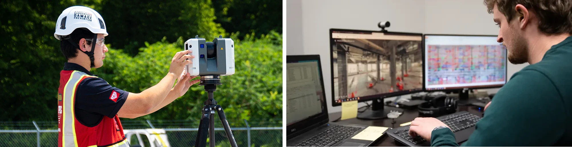
3D laser scanning provides a record of the current building information, including architectural, structural, utility, and MEP system dimensions, locations, and material specifications. This information is essential for project planning. Whether you’re an architect planning a renovation, an engineer validating structural tolerances, a contractor racing against a schedule, or a facility manager managing an equipment upgrade, 3D laser scanning has become an essential tool for capturing the physical reality of buildings and sites with millimeter-level accuracy.
By converting physical spaces into rich, measurable point clouds, CAD drawings, and BIM models, 3D laser scanning informs decision-making, reduces rework, and streamlines coordination across the entire project lifecycle.
But the real value comes from matching the right 3D laser scanning approach to the right use case because layout verification, clash detection, prefabrication, and facility management all demand different accuracy requirements, workflows, and deliverables.
So how do you decide what’s right for your project? This article discusses what general contractors, engineers, architects, and facility managers consider when defining and evaluating 3D laser scanning services, helping to ensure the technology delivers value where it matters the most.
What Should You Consider Prior to Selecting a 3D Laser Scanning Provider?
Choosing the right 3D laser scanning service starts with understanding the specific needs of your project. Selecting the right scanning approach isn’t “one size fits all.” Several key factors can help determine the reality capture solution that is best for your project.
1. Project Objectives
First, assess what you are trying to accomplish, whether it’s capturing as-built conditions to plan a renovation for adaptive reuse, complete a manufacturing plant retrofit, or verify construction progress.
What will the scan data be used for?
- Design & Planning: Are you creating floor plans, elevations, or site layouts?
- Construction & BIM: Will the data feed into a Building Information Model (BIM)?
- Facility Management: Is the goal to create a digital twin to support asset tracking, maintenance, or space planning?
- Inspection & Analysis: Do you need to detect structural issues, measure tolerances, or perform clash detection?
2. Project Scope
To accurately define the scope for a 3D laser scanning project, it’s important to assess several key factors. These include the total square footage of the area to be scanned, the number of levels or floors involved, and whether the space is currently occupied. Additionally, clarify the requirements of the scan, whether it includes the interior, exterior, roof, MEP equipment, or a comprehensive site capture.
3. Stakeholders
Start by identifying who will be using the 3D laser scan data, whether it's architects, engineers, contractors, building owners, or facility managers. Understanding each stakeholder’s role is essential for determining the scanning approach and deliverables. Be sure to clarify their preferred software platforms, such as Revit, AutoCAD, or Navisworks, as this will influence the required data formats and level of detail.
Before selecting a scanning service or technology, involve your stakeholders early in the planning process. Their input can help define expectations around modeling standards, software compatibility, and data integration. This collaborative approach ensures the scan data fits seamlessly into your project workflow and helps avoid costly rework or format conversions later.
4. 3D Laser Scanning Equipment Needed
The layout and complexity of the building or site plays a major role in selecting the appropriate 3D laser scanning technology. Large-scale environments, such as construction sites, infrastructure projects, or multi-story buildings, require terrestrial scanners that have long-range capabilities and high accuracy. In contrast, scanning detailed elements like MEP systems or interior layouts may call for high-resolution scanners with greater mobility. Architectural features such as facades, curved surfaces, tight spaces, or structural irregularities will influence which type of 3D laser scanning equipment is most suitable for the job. Handheld scanners are ideal for capturing quick snapshots or accessing hard-to-reach areas, while tripod-mounted or terrestrial scanners offer superior precision for comprehensive scans, though they are less portable.
5. Accuracy & Resolution Requirements
The required level of detail depends on how the scan data will be used. For example, as-built documents for renovations need millimeter-level accuracy. In contrast, general site surveys can have lower accuracy requirements. High-resolution 3D laser scanners are crucial for tasks such as clash detection, prefabrication, and structural analysis. In these areas, precision is key and cannot be compromised. Low accuracy requirements could help create conceptual design plans for a new building.
6. Scan Environment & Accessibility
Some 3D laser scanning projects take place in challenging environments, for example, scanning dense MEP systems, low-light conditions, or areas with limited physical access. These factors can impact the performance of certain scanners. It’s important to choose a scanner that can operate effectively in low-light settings and navigate dense equipment and tight crawlspaces. Additionally, consider whether the scanner supports tripod mounting, handheld use, or both, depending on your project scope.
Keep in mind that LiDAR technology cannot penetrate solid objects. Therefore, it’s essential to plan your scanning strategy carefully to ensure that critical areas are not obstructed by furniture, equipment, or structural barriers. A thorough site scan strategy will ensure complete data capture and minimize return trips.
7. Intended Use of Scan Data
Understanding how the scan data will be used is essential when selecting a 3D scanner and its accompanying software. Whether you're creating 2D floor plans, developing BIM models, tracking construction progress, managing facilities, or conducting structural inspections and clash detection, each application has specific requirements. The scanner must be capable of producing point cloud data in compatible formats such as E57, RCP, LAS, or OBJ, and should integrate smoothly with industry-standard tools like Revit, Navisworks, AutoCAD, or Civil 3D. Clearly defining the purpose of your scan ensures that both the hardware and software will support your workflow efficiently and deliver the quality and compatibility needed for successful outcomes.
8. Timeline
Do you need a fast turnaround for a tight timeline? Time is always a critical factor in project management. High-speed scanners can capture entire rooms or building exteriors in minutes. This speed is crucial for large jobsites. Some 3D laser scanning systems offer automated scanning or batch processing, improving efficiency for repetitive tasks. But, faster isn’t always better, make sure that the scanner maintains accuracy to avoid compromising data quality.
9. Budget
When planning for 3D laser scanning, it’s important to consider your budget. Pricing varies by equipment, project complexity, location, and turnaround time. To make an informed decision, ask 3D laser scanning service providers to break down what’s included in their pricing, such as scan coverage, file formats, post-processing, and revision cycles. Comparing deliverables, not just quotes, can reveal which service offers better long-term value. A slightly higher upfront cost may be worthwhile if it includes comprehensive data preparation and integration support, ultimately reducing your internal workload. A transparent provider will offer a detailed quote and clearly explain what’s included, helping you avoid surprises and ensuring the service aligns with your financial expectations.
Read Article: How Much Does 3D Laser Scanning Cost?
What are the Use Cases for 3D Laser Scanning in Architecture, Engineering, Construction, and Facility Management?
Architectural Use Cases for 3D Laser Scanning
As-Built Documentation
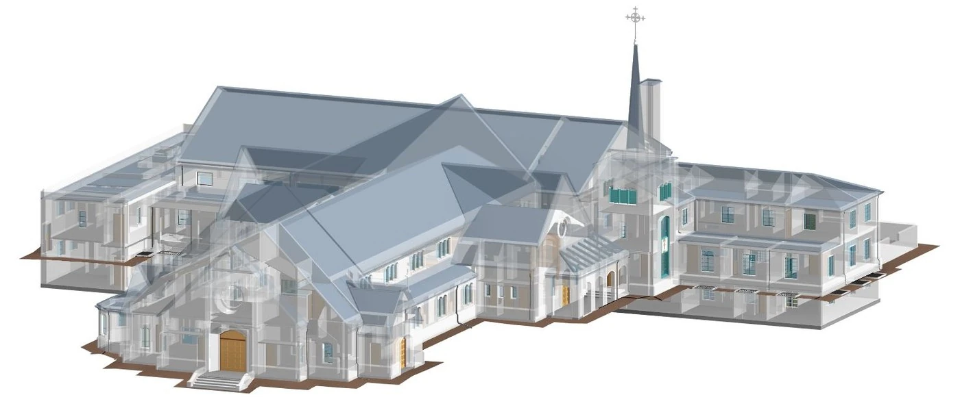
Architectural firms use 3D laser scanning to capture highly accurate as-built geometry to establish a reliable baseline for design. This information is critical for renovations, adaptive reuse, and heritage projects, especially when original drawings are outdated or missing. 3D laser scans provide millimeter-level detail, reducing the risk of errors and surprises during design and construction.
Design Validation
Architects can use 3D laser scan data to compare design models to actual site conditions to identify discrepancies early. This process helps architects and design teams avoid costly redesigns by ensuring that proposed layouts align with real-world conditions before construction begins.
Façade and Envelope Studies
The building’s façade and envelope can be thoroughly analyzed for its geometry, alignment, and material conditions. 3D laser scanning aids this process by capturing precise surface data that evaluates structural integrity, surface conditions, deformation, energy efficiency, window and door placement, ornamental details for restoration, and more. This detailed information helps to make informed design decisions, ensuring that exterior elements are properly evaluated and integrated into the architectural project plan.
Historic Preservation
3D laser scanning documents heritage structures in high-resolution point clouds for restoration, repair, and archival purposes. These scans serve as a permanent digital record for architects, enabling accurate reproduction of ornamental details and compliance with preservation standards.
Engineering Use Cases for 3D Laser Scanning
Structural Analysis
Engineers use 3D laser scanning to measure deflection, settlement, and deformation in structural components such as beams, columns, and slabs over time. This technology enables early detection of structural movement and helps create a digital record that can be used to meet safety rules or investigate issues later. By comparing scans taken at different times, engineers can plan repairs before bigger problems happen.
MEP Coordination
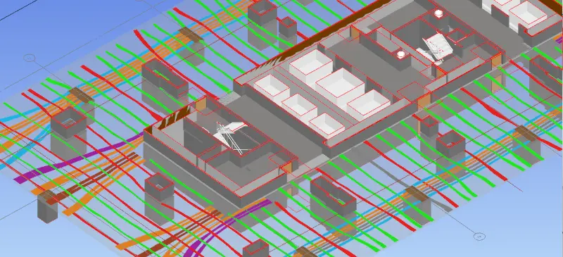
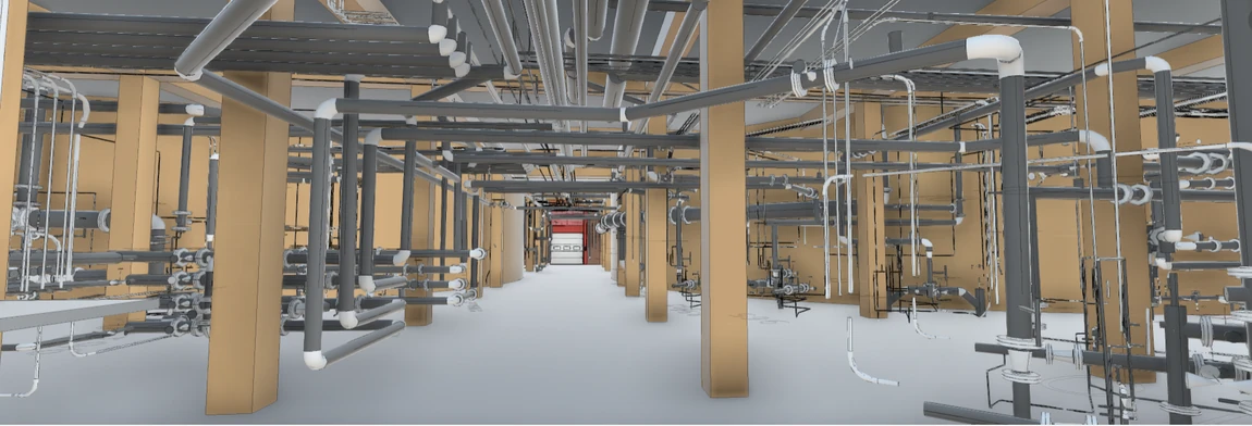
Mechanical, electrical, and plumbing systems often compete for limited space within ceilings, shafts, and plant rooms. 3D laser scanning captures existing conditions with millimeter-level accuracy, allowing engineers to detect potential clashes and validate routing within CAD and BIM environments. This ensures efficient coordination and reduces the risk of installation conflicts.
Tolerance Verification
To ensure that steel, piping, and equipment installations meet fabrication tolerances, engineers rely on laser scanning to compare as-built conditions against design models or fabrication drawings. This verification process helps confirm that components fit as intended, minimizing costly adjustments in the field.
Load Path and Clearance Checks
Projects involving cranes, conveyors, or heavy equipment installations must confirm that load paths and clearances are sufficient. 3D laser scanning creates a detailed 3D environment where these paths can be simulated and validated, ensuring safe and efficient equipment placement.

Construction Use Cases for 3D Laser Scanning
Layout Verification
Before concrete is poured or structural steel is placed, even minor deviations in the positioning of anchor bolts, embeds, or sleeves can lead to significant alignment issues later in the project. 3D laser scanning provides millimeter-level accuracy to verify that these elements are correctly positioned relative to the design model. This proactive verification helps reduce the risk of costly rework and schedule delays.
Clash Detection
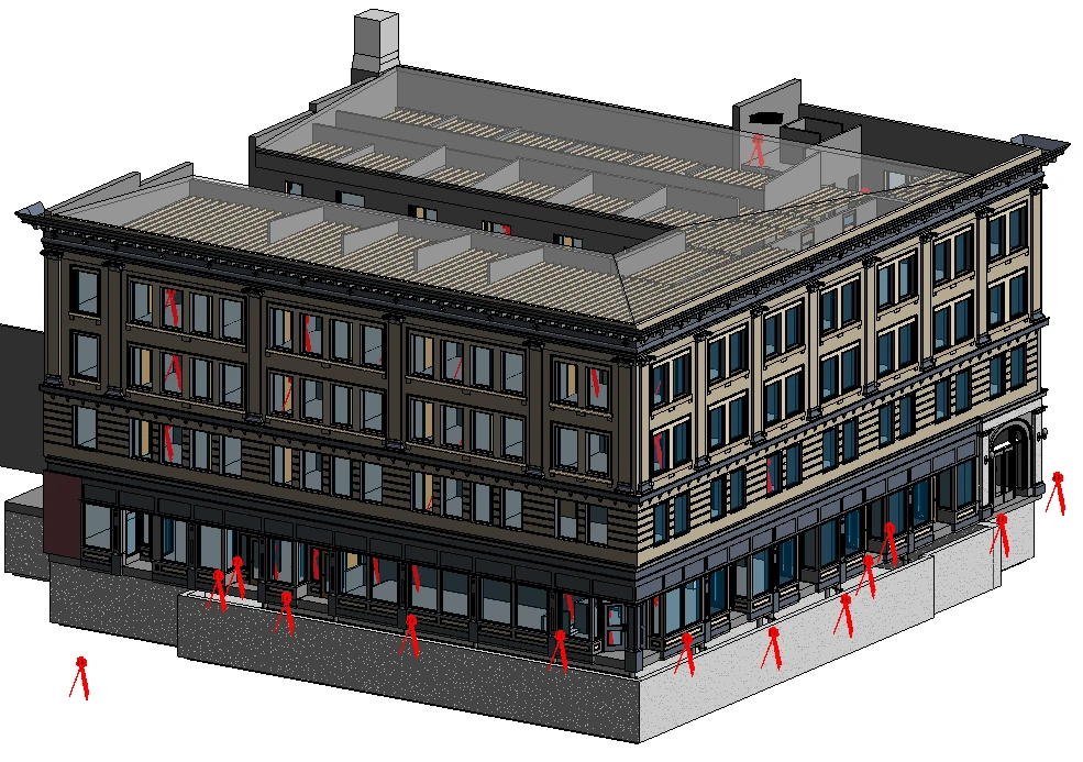
When integrating new design models with existing site conditions, hidden conflicts can disrupt progress and increase costs. 3D laser scanning captures the true geometry of the site, allowing project teams to overlay point clouds with BIM models and identify potential clashes early. This ensures that mechanical, electrical, plumbing, structural, and architectural elements fit together as intended during installation.
Prefabrication
For prefabricated assemblies such as pipe racks, ductwork, or façade panels, dimensional accuracy is critical. Laser scanning validates field dimensions and tolerances before fabrication begins, helping to ensure that prefabricated components will fit correctly upon delivery. This reduces waste, minimizes rework, and supports a more efficient installation process.
Progress Monitoring
By conducting frequent comparisons of point clouds to the 3D design model, project teams can verify the completeness of installations, detect deviations from the plan, and document work upon completion. This ongoing monitoring supports quality control and provides a reliable record of construction progress.
Facility Management Use Cases for 3D Laser Scanning
Digital Twin Creation
Creating a digital twin of your facility establishes a reliable baseline for ongoing operations, maintenance, and space planning. This digital representation enables real-time monitoring and seamless integration with building management systems, improving overall efficiency.
Asset Tagging and Inventory
Accurate asset tagging and inventory management are also key benefits of 3D laser scanning. The technology helps you track equipment locations, serial numbers, and metadata. You can then integrate this data into your Computerized Maintenance Management System (CMMS). This ensures precise asset tracking and helps reduce downtime during repairs or replacements.
Facility Layout
Laser scanning also supports facility layout and space utilization by validating room dimensions and occupancy levels. This data can be used to ensure compliance with regulations and optimize space allocation, contributing to more effective energy efficiency strategies.
Retrofits and Renovations
For facility renovations, having accurate as-built documentation allows facility managers to plan upgrades and retrofits without the need for intrusive surveys. This reduces project risk, minimizes disruption to building occupants, and streamlines the renovation process.
What Types of Equipment Can Be Used for 3D Laser Scanning?
Terrestrial Laser Scanners
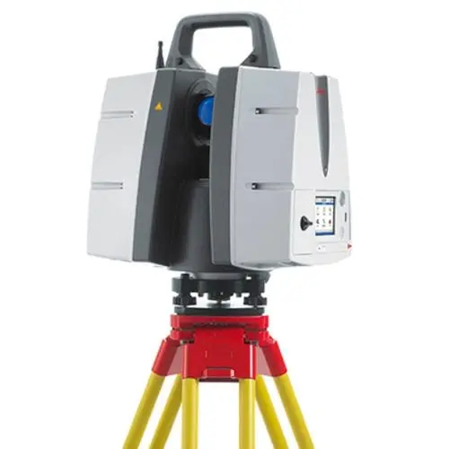
Terrestrial Laser Scanning (TLS) uses stationary, tripod-mounted 3D laser scanners. These scanners send out laser pulses to capture millions of accurate 3D points of objects, buildings, or sites. They are often used for the reality capture of building interiors, structural steel, façades, and other projects that require high accuracy. These systems typically achieve an accuracy of ±2–5 mm at ranges of 10–30 meters, which is why they’re commonly used in situations requiring exact measurements. Terrestrial 3D laser scanners include Leica Geosystems, FARO Focus series, and RIEGL VZ series, Trimble, and Topcon.
Mobile Mapping Systems
Mobile Laser Scanning (MLS) and SLAM-based systems fit into mobile platforms. These include handheld devices, backpacks, and vehicle-mounted scanners. Mobile Laser Scanning (MLS) and SLAM-based systems use special tools. These include a laser scanner (LiDAR sensor), an Inertial Measurement Unit (IMU), and often a Global Navigation Satellite System (GNSS). They gather real-time 3D point clouds. Then, they combine the scanner's position with the environment's structure to create maps. This approach is best suited for large interiors, complex layouts, and projects where speed is more important than sub-millimeter accuracy. Accuracy generally falls in the ±10–30 mm range, depending on control and loop closures. Mobile mapping systems include the NavVis VLX, FARO, Leica Geosystems, GeoSLAM, Trimble, Artec, and Riegl.
Aerial LiDAR
Aerial LiDAR is deployed via drones or aircrafts to capture terrain, roofs, and large outdoor areas efficiently. Aerial LiDAR is commonly used for site surveys and topographic mapping. Accuracy typically ranges from ±20–50 mm, influenced by altitude and GNSS quality. Examples of aerial LiDAR systems include the DJI L1 and RIEGL’s airborne platforms.
Photogrammetry
Photogrammetry uses high-resolution overlapping photographs processed with specialized software to generate 3D models and point clouds. While it is generally less accurate than LiDAR, offering ±20–50 mm accuracy, it is cost-effective and ideal for capturing interior layouts and floor plans where ultra-high precision is not required. Photogrammetry is often combined with drone platforms for rapid coverage and can be enhanced with survey control points to improve accuracy. Brands offering stationary LiDAR photogrammetry are Leica Geosystems, FARO, RIEGL, Artec 3D, and Matterport.
If you need the highest accuracy for prefabrication or clash detection, terrestrial laser scanning with survey control is the best choice. But if speed and coverage across large interiors matters more, mobile laser scanning can deliver better efficiency, provided everyone understands its accuracy limits and follows proper quality checks. For expansive sites, aerial LiDAR offers rapid data capture over large or inaccessible areas.
Read more about the equipment used for 3D laser scanning.
Why Do Architects, Engineers, General Contractors, and Facility Managers Choose 3D Laser Scanning?
AEC companies choose 3D scanning for its unmatched precision, speed, and versatility, which leads to significant cost savings and more efficient workflows across a range of applications. The technology digitizes physical objects into highly accurate point clouds, CAD drawings, and 3D models, enabling companies to reduce errors and accelerate project lifecycles.
General contractors often turn to 3D scanning to keep projects on schedule and minimize disruption. Mobile scanning systems can capture large areas quickly, even during off-hours, while high-precision tripod-based scanning is reserved for tasks that demand tight tolerances, like verifying embeds or prefabricated components.
Engineers value 3D laser scanning for its accuracy and traceability, using it to confirm structural alignment, check flatness, and generate reliable data for analysis.
Architects rely on 3D laser scanning to document existing conditions and ensure their models reflect reality, which helps to avoid design conflicts later.
For facility managers, 3D laser scanning creates a detailed digital record of the building, supports asset tracking, and provides a foundation for digital twins, making future maintenance and renovations far easier.
Each role uses scanning to reduce risk, improve coordination, and make better decisions with confidence.
How Can GPRS 3D Laser Scanning Services Help You?
The key to maximizing the value of 3D laser scanning lies in aligning the scanning approach with the specific use case.
You can trust the GPRS team to provide the best experience in laser scanning by walking you through the entire 3D laser scanning process from pre-planning to project completion.
We offer a consultative approach to project management, working with you to ensure our data, maps, and models are the perfect solution for your project. The data delivered is accurate within millimeters, and the maps and models provide complete as-built and location data.
GPRS serves a wide variety of industries, including architecture, engineering, design, construction, oil & gas, facility management, historical preservation, stadium & theater, education, healthcare, water & wastewater, energy & utilities, and multimedia & entertainment industries.
Our elite team of Project Managers must complete an extensive training program before they perform field services on your job site. The program includes 80 hours in the classroom, more than 320 hours of field mentorship, and 40 hours of specialized LiDAR training. This ensures mastery of top Leica equipment and techniques. Project Managers gain practical experience at a dedicated training facility in Ohio and learn the full scope of the 3D laser scanning process, from project planning to final data delivery.
At GPRS, we ensure you have all the information you need to get the job done right, delivering accurate as built data to expedite project planning and reduce change orders, delays, and costs.
What can we help you visualize?