

.svg)
Utility Locating for Power Plant Security Fence Installation
When a nuclear power plant plans to install a new security fence, accuracy beneath the surface matters just as much as the precision above it.
At a power plant on the coast of Lake Michigan, a general contractor required verified underground utility locations across dozens of targeted areas to safely construct a new security fence. This included planning for augered fence posts, surface set concrete blocks, and hydro excavated footers, all of which needed to be installed without causing utility strikes, service outages, or security incidents.
GPRS Project Summary
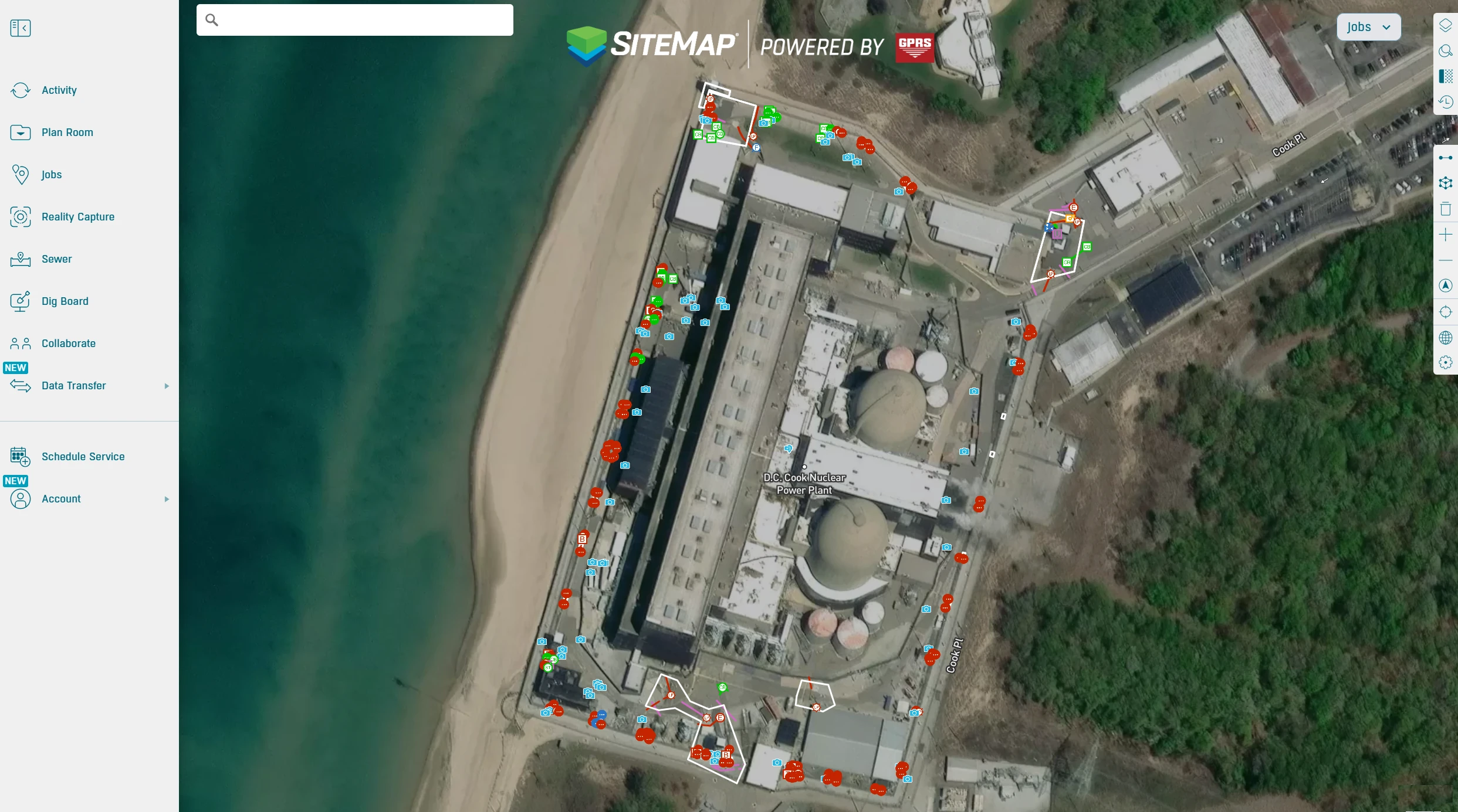
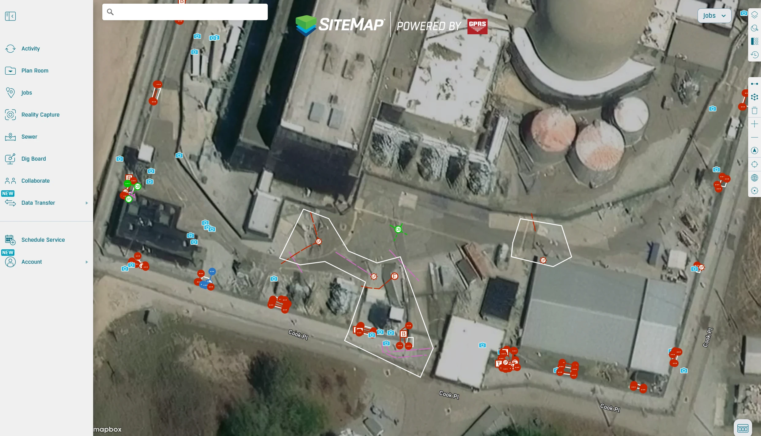
GPRS partnered with the power plant’s general contractor to provide utility locating and mapping to support the design and installation of a new security fence. This project required locating and mapping of dozens of work areas. GPRS delivered field validated digital maps that helped to keep the project safe, compliant, and on schedule.
Objective: Support installation of a new security fence by locating and mapping public and private underground utilities across multiple work areas.
Scope: Clearances for 30 areas in preparation for 4 ft. x 4 ft. concrete block installation; 2 areas planned for hydro excavated footers, plus 4 locations to check for buried concrete at fence posts.
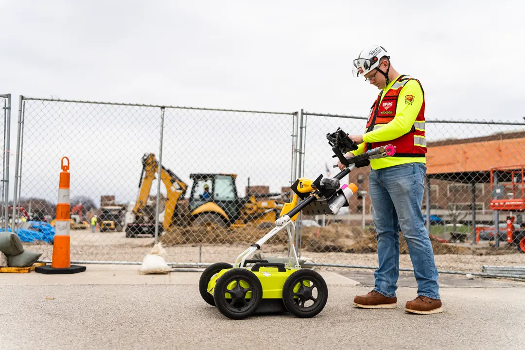
Technologies: Ground penetrating radar (GPR) and electromagnetic (EM) locating technology was used to identify all public and private utilities, including metallic and non metallic lines.
Deliverables: Utilities were clearly marked on the surface using paint, flags, and other appropriate indicators. All findings were captured via GPS and delivered through SiteMap®, GPRS’ GIS platform, as CAD/PDF maps along with KMZ and SHP file exports.
The Challenge
Security fencing at a nuclear power plant is subject to strict federal regulations designed to prevent unauthorized access, maintain continuous operations, and protect vital equipment.
According to the United States Nuclear Regulatory Commission (NRC), the security fencing at nuclear power plants requires a high-security, multi-layered perimeter designed to detect, delay, and defend, typically involving two 8-foot chain-link fences topped with barbed wire, separated by a sterile, monitored "no man's land" isolation zone. These barriers must meet NRC regulations in 10 CFR 73.55.
Security barrier enhancements are often driven by intelligence updates and regulatory requirements. The NRC states that work near or within these zones must be planned to avoid creating vulnerabilities or triggering alarms.
Before any drilling or excavation takes place, thorough subsurface due diligence is essential to safeguard the power plant. Because private utilities at power plants are not typically marked by 811, the site may contain high voltage feeders, water and storm lines, communication pathways, and other specialized plant systems that must be identified and mapped before work begins. Hiring a private utility locator is a critical step to prevent accidental damage to critical infrastructure during the installation of security barriers, because even a single utility strike can jeopardize safety, disrupt operations, and trigger compliance violations.
Nuclear power plants also follow strict, multi layered personnel access authorization protocols to verify identity and ensure only qualified individuals enter secure areas. This process includes REAL ID–compliant identification, comprehensive background checks, including fingerprinting, criminal history, credit review, and employment verification and approval only after completing required safety training and fitness for duty evaluations.
The GPRS Approach: Utility Locating at a Nuclear Power Plant
GPRS partnered with a general contractor to provide utility locating, mapping, and digital deliverables to prevent damage, injuries, and delays. The GPRS Project Managers on location at the nuclear power plant completed the personnel access authorization requirements.
GPRS Project Managers follow Subsurface Investigation Methodology (SIM) to accurately locate, mark, and map underground utilities and concrete structures. SIM combines the expertise of highly trained technicians, each completing 320 hours of mentored field training and 80 hours of classroom instruction, with multiple technologies, including ground penetrating radar (GPR) and electromagnetic (EM) locating. This standardized approach consistently delivers a 99% accuracy rate, helping prevent costly and dangerous utility strikes.
Once utilities are located, all findings are marked on the surface and captured with GPS for a complete set of digital deliverables in SiteMap®, including CADD/PDF maps, KMZ/SHP files, and a collaborative web viewer. GPRS provided the GC and plant stakeholders with a single source of truth for planning excavation locations, confirming clearances, and sequencing work inside the nuclear power plant.
Deliverables
Field Markings: Paint and flags to guide crews in real time.
Digital Utility Maps: Delivered through SiteMap®, including CADD/PDF, KMZ, and SHP files for design teams and security stakeholders.
Benefits
Safe Excavation: Underground utility locating and mapping identifies the precise depth and position of utilities, mitigating the risk of accidental strikes during excavation, which can lead to electrocution, explosions, or hazardous leaks. It significantly reduces the danger to workers and surrounding communities.
Preventing Costly Damages and Delays: Knowing the exact location of utilities prevents costly damages and emergency repairs, which can derail project schedules and budgets.
Security Aligned Planning: Subsurface data supports construction sequencing that respects protected area controls and minimized potential system impairments.
Regulatory Compliance: Accurate mapping provides documented evidence of due diligence, helping power plants comply with stringent federal and local safety standards.
Shared Digital Maps: SiteMap® centralizes utility data so the GC, facility managers, and security teams could coordinate from the same, current map.
Final Recommendations
Effective planning and documentation are essential when upgrading security infrastructure at a power plant. To keep projects safe, compliant, and on schedule, teams must take a strategic approach to subsurface investigation and construction planning.
First, plan with a security first mindset. Treat every fence upgrade as critical security work, ensuring construction activities align with the plant’s protected and vital area controls. This helps maintain regulatory compliance and prevents disruptions to sensitive systems.
Next, insist on private utility locating. Because 811 does not mark most privately owned utilities within power plants, specialized locating is essential to avoid strikes to high voltage lines, water and storm systems, and other critical infrastructure.
Finally, document everything thoroughly. Provide facilities and security teams with GIS ready maps, update them as conditions change, and ensure all stakeholders have access to current data for safe, coordinated decision making throughout the project lifecycle.
Partner with GPRS for Safe, Accurate Project Planning
With GPRS as your partner, you gain the field verified data and expert support you need to eliminate guesswork, reduce risk, and keep your project on track. No matter the complexity of your site, we deliver the clarity needed to make safe, informed, compliant decisions, from planning through execution.
How can GPRS support your project?
Frequently Asked Questions
Why is private utility locating required at a nuclear power plant?
Because 811 does not mark most privately owned utilities inside a nuclear facility, specialized locating is essential to identify high‑voltage lines, water and storm systems, communications pathways, and other plant‑specific infrastructure. Accurate locating prevents dangerous utility strikes, protects plant operations, and supports NRC‑aligned security requirements during fence construction.
What technologies does GPRS use to locate utilities safely in a high‑security environment?
GPRS uses a combination of ground penetrating radar (GPR) and electromagnetic (EM) locating, supported by GPS mapping and deliverables through SiteMap®. This multi‑technology approach provides the accuracy needed to plan augered posts, concrete block placements, and hydro‑excavated footers without risking outages or system damage.
How does GPRS maintain compliance with nuclear security and access requirements?
All GPRS Project Managers working onsite must meet the plant’s personnel access authorization requirements, which typically include identity verification, background checks, safety training, and fitness‑for‑duty screening. This ensures locating work can be completed safely, efficiently, and in alignment with the plant’s protected‑area and regulatory controls.