

.svg)
Photogrammetry has become an essential reality capture tool in the architecture, engineering, construction, and facilities management industries, offering the ability to convert photographs into accurate 2D floor plans, 3D models, and immersive virtual tours.
By capturing buildings and infrastructure and translating them into digital assets, photogrammetry supports a wide range of workflows, from planning and design to execution and long-term maintenance.

Why Documentation Matters
Accurate documentation is critical at every stage of a construction project.
Architects and engineers use reality capture photogrammetry during the design phase to ensure their plans align with existing building conditions. General contractors rely on it for pre-construction planning and to verify progress at key milestones, helping to ensure the project stays on track and meets specifications.
Once construction is complete, facility managers depend on this data to locate critical systems and streamline maintenance, saving time and reducing operational costs.
CAD and BIM Creation with Photogrammetry
Photogrammetry enables architecture, engineering, and construction (AEC) professionals to rapidly convert buildings and infrastructure into precise digital assets.
Through scan-to-BIM workflows, high-resolution images are transformed into 2D floor plans and 3D models that integrate seamlessly with CAD software and BIM platforms like Autodesk Revit. This technology accelerates as-built documentation, reduces manual modeling, improves accuracy, and enhances collaboration across project teams.

What Can Be Created with Photogrammetry Data?
2D Floor Plans
Scaled representations of a building’s layout, showing walls, doors, windows, and room dimensions. 2D floors plans are ideal for planning, renovations, real estate, and emergency response.
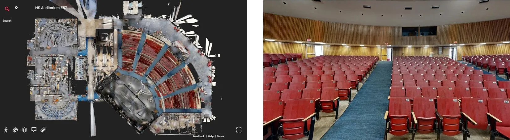
3D Models
Using formats like E57, photogrammetry produces detailed digital twins compatible with Autodesk Revit, AutoCAD, and Navisworks. These 3D models support virtual design, material estimation, post-construction documentation, and facility management.
Virtual Tour
Capturing 134.2 MP panoramic HDR images, photogrammetry enables interactive, navigable 3D virtual tours. These are commonly used in real estate, construction progress tracking, and facility management.
Point Cloud
With up to 1.5 million points per scan, photogrammetry generates dense 3D point clouds that capture the exact shape and surface of architectural, structural, and MEP elements, forming the foundation for accurate CAD and BIM modeling.
2D Photography
4K high-resolution images captured during the photogrammetric process can be used for visual documentation, inspection, and reference throughout a project’s lifecycle.
What are the Advantages of Photogrammetry Scan-to-BIM Workflows?
Faster Capture of As-Built Conditions
Rapid photogrammetry scanning, often completed in seconds, outpaces traditional LiDAR methods.
Seamless Integration with Design Software
Easily import photogrammetry data into Autodesk Revit and other BIM platforms.
Automated Model Generation
Generate LOD 200 BIM-ready files in IFC or RVT formats, reducing manual work.
Improved Collaboration and Accessibility
Share digital twins for real-time stakeholder collaboration.
Reduced Errors and Rework
High-accuracy scans reduce costly rework by identifying issues, such as electrical or plumbing conflicts, before they become hidden behind drywall.
Swinerton Keeps Construction Moving Forward with Digital Twins
Swinerton, a leading construction firm, leveraged digital twin technology to keep projects on track. By using photogrammetry to create immersive 3D walkthroughs of job sites, Swinerton eliminated the need for in-person visits, reduced client travel by 100%, and reduced architect and MEP travel by 50%. This approach not only saved time and costs but also prevented project delays and rework. The digital twins enabled real-time collaboration, precise measurements, and streamlined issue resolution, helping Swinerton shave weeks off project timelines and enhance communication across teams.
What Industries Use Photogrammetry?
Photogrammetry is transforming the architecture, engineering, and construction industry by making reality data capture faster, more accurate, and more accessible. From planning and design to execution and maintenance, its applications are vast and impactful.
Construction
Used to capture detailed site and building imagery data for accurate planning, visualization, and documentation.
Civil Engineering
Supports the design of roads, bridges, airports, and utilities through terrain mapping and infrastructure modeling.
Structural Engineering
Provides precise models for assessing building integrity, planning reinforcements, and designing new structures.
Cultural Heritage & Preservation
Digitally documents historical sites and artifacts for assessment, restoration, research, and virtual tourism.
Real Estate
Enhances listings with virtual tours, floor plans, and high-resolution imagery to attract buyers and renters.
Industrial & Facility Management
Aids in asset documentation, space optimization, and maintenance planning for facilities and plants.
Case Study: Hotel Renovation Design Planning with 3D Photogrammetry
GPRS used 3D photogrammetry to capture over 600,000 square feet of interior space across four hotel properties in Dayton and Cleveland, Ohio. The client needed accurate 2D floor plans of guest rooms, common areas, meeting spaces, and offices to support renovation planning, without disrupting hotel operations or reducing guest occupancy.
The non-intrusive photogrammetry scanning process delivered precise as-built documentation in a single mobilization for each hotel, eliminating the need for return site visits. This efficient approach provided the design team with comprehensive spatial data while preserving the guest experience and streamlining project timelines.
"The scans were great. I’m a believer. We couldn’t have done this project without it. We will never do a renovation again without a scan so we will be calling you." - Chuck T.

Can GPRS Provide Photogrammetry Services?
Yes. GPRS Photogrammetry Services provide customers the opportunity to better manage design, construction, and operations with a digital record of their space. All architectural, structural, and MEP system details, plus utility locates and concrete markings can be documented with 20-millimeter accuracy.
3D photogrammetry delivers GPRS’ clients precise spatial data for planning, analysis, and calculations. Clients can extract geometric information from the two-dimensional images. Overlapping photographs can be rectified to create digital twins, 2D floor plans, virtual tours, 3D models, LiDAR point clouds, topographical maps, and more. This precise data aids in project planning, execution, and ongoing maintenance.
Read more about photogrammetry.
For more information, contact us today at 419-843-7226 or email laser@gprsinc.com.
What can we help you visualize?
Frequently Asked Questions?
How does 3D photogrammetry work?
Photogrammetry uses overlapping images captured from different angles to create precise digital twins, 2D floor plans, virtual tours, 3D models, LiDAR point clouds, topographical maps, and more. Specialized software analyzes the photos, identifies common points, and reconstructs depth, shape, and texture.
What is the Meaning of Photogrammetry?
When you break down the word photogrammetry – “photo” refers to light, “gram” means drawing, and “metry” refers to measurements. Photogrammetry uses photos to gather measurements from which drawings, maps, and models can be created.
What is the Science Behind Photogrammetry?
Triangulation is the principle used by photogrammetry to produce three-dimensional coordinates. By mathematically intersecting converging lines in space, the precise location of a point can be determined.
What is the Difference Between Photogrammetry and LiDAR?
Photogrammetry and LiDAR are both remote sensing reality capture techniques used to create as-builts, but they differ significantly in how they capture data and the resulting accuracy. Photogrammetry uses photographs to derive measurements, while LiDAR uses lasers to directly measure distances.