

.svg)
GPRS’ 99.8% accurate underground utility scans provided an electrical substation in Austin, Texas the confidence needed to safely dig on site.
S&K Electrical needed to install a new communications tower and contacted GPRS to help make sure they did it safely.
Project Manager Daniel Reis went on site to provide accurate utility locations and excavation clearances for the proposed installation site.
Before the installation, they needed to know the locations and depths of an underground electrical line and the substation’s grounding grid. Without this information, the risk of a line strike is very high.
Another utility locating company had provided information on a buried electrical line, but S&K needed verification, so they brought Reis out to verify the location of both the electrical line and the grounding grid before they broke ground.
“They had an idea of where it was at, but they wanted to make sure they knew where it was at before they started digging,” Reis explained. “So, I was able to tell them with certainty, ‘the grounding grid is right here, it crosses here, and here's the grid pattern.’ That's pretty much where they figured, but they needed to know for certain what they were dealing with.”
Reis used ground penetrating radar (GPR), electromagnetic (EM) locators, and induction clamps to meet the client’s requests.
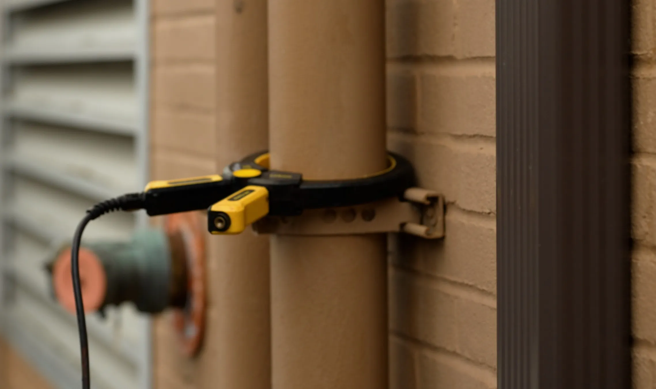
Induction clamps assist with the location of power or electrical lines when it is placed around a pipe or cable that is grounded at both ends to induce a frequency. EM locators can trace the frequency produced by the clamps, allowing PMs to precisely map the locations and depths of grounded subsurface utilities.
GPRS Project Managers are trained in Subsurface Investigation Methodology (SIM). A main principle of SIM is that all PMs use complementary technologies. This helps them sustain 99.8% accurate underground utility scans. GPR and EM locators are a prime example of that as they each have capabilities that, when combined, ensure accurate results.
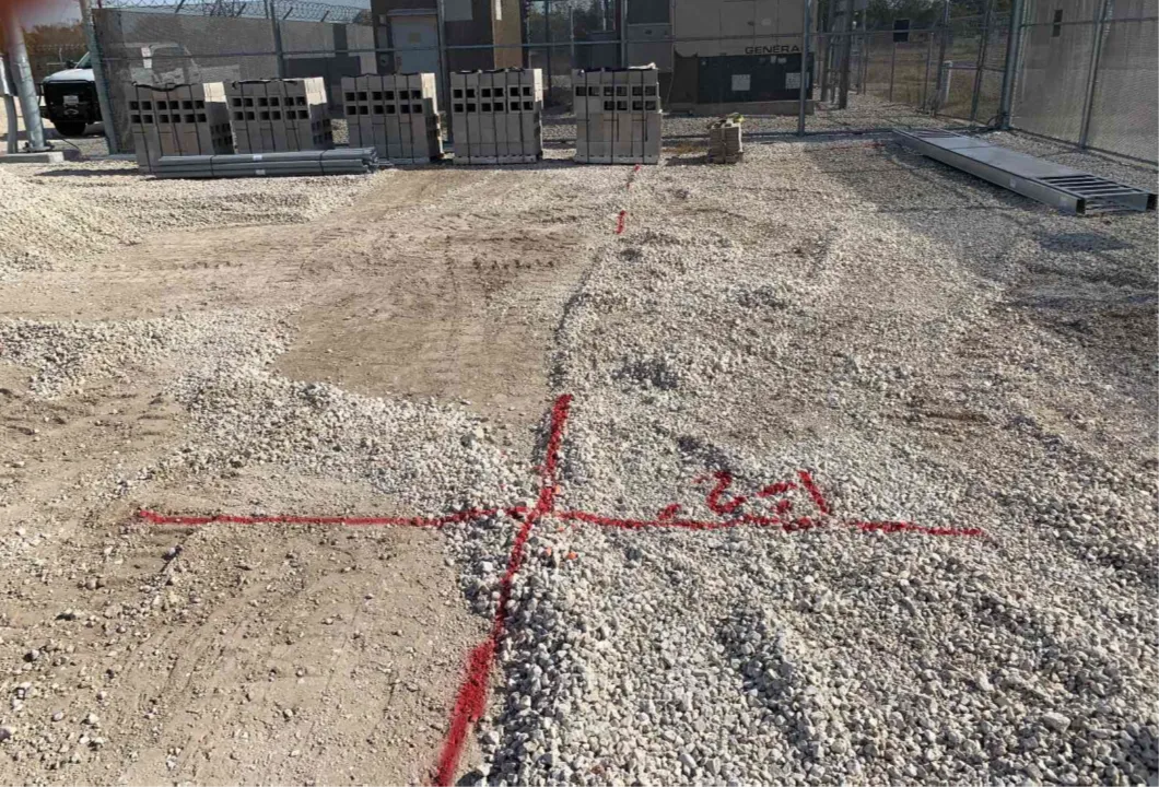
Reiss used the same combination of technologies to verify the location of the grounding grid. He marked all his findings with red spray paint, including the depths of the subsurface utilities.
Reiss also conducted a post-scan site walk with the client to explain his findings and ensure they know where it is, and isn’t, safe to break ground.
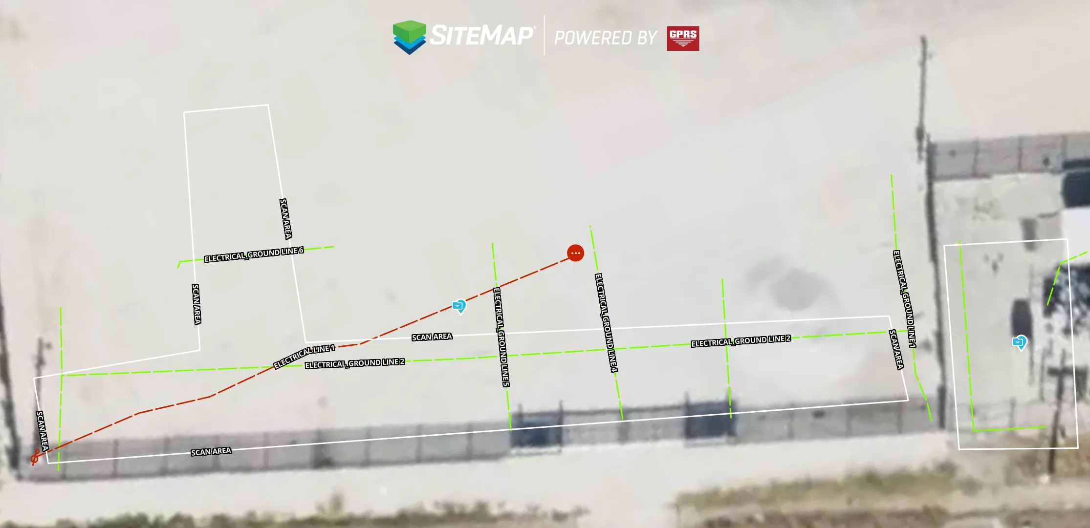
Since spray paint doesn’t last forever, Reiss used GPS positioning to create a map of his findings and uploaded them into SiteMap® (patent pending) for the client to review at a moment's notice. SiteMap is GPRS’ cloud-based infrastructure management platform that securely stores our clients’ site data in one place to allow for better communication across teams and fewer delays caused by utility strikes.
Thanks to Reiss’ precise and timely results, the client was able to dig with confidence and knows they can rely on data provided by GPRS.
“They were really pleased that I was able to get out there so quick and get them everything that they needed,” Reiss explained. “Since then, I've gotten phone calls directly from them asking me for future locates.”
From substations to skyscrapers, GPRS Visualizes the Built World® to keep your projects on time, on budget, and safe.
What can we help you visualize?
FREQUENTLY ASKED QUESTIONS
What types of deliverables do I get when I hire GPRS to conduct a utility locate?
Our Project Managers flag and paint our findings directly on the surface. This method of communication is the most accurate form of marking when excavation is expected to commence within a few days of service. GPRS also uses Real-Time Kinematic (RTK) Positioning and Robotic Total Stations (RTS) to collect data points of findings. We use this data to generate a plan, KMZ file, satellite overlay, or CAD file to permanently preserve results for future use. GPRS does not provide land surveying services.
How does GPRS contribute to jobsite safety in construction?
GPRS’ #1 focus is safety and part of our mission is the pursuit of 100% subsurface damage prevention because sending your team home safe and sound every day is the most important job we can help you do.
Our Subsurface Investigation Methodology (SIM) provides the gold standard in underground utility locating and concrete scanning, so we can help you ensure your team is clear to cut, core, or drill with confidence. Our Video Pipe Inspection services provide NASSCO-compliant PACP-coded defect and condition reporting, pipe locations, and more. And, our reality capture services provide 2-4 millimeter-accurate structural measurements to help you avoid clashes, reworks, and downtime. Because when you know what’s hidden/underneath, you can build more safely.
What is SIM?
Subsurface Investigation Methodology is a standard operating procedure and set of professional specifications that work as a guide for utility locating experts when scanning for buried utility lines. It is also the standard GPRS requires for its Field Team and Project Managers.
SIM-certified utility locators provide superior results including GPRS’ industry leading 99.8% accuracy rate on scans from hundreds of thousands of projects.
SIM’s purpose is to yield precise results and lower hit rates through its three primary elements: experience-based training, technological strategies, and comprehensive methods.