

.svg)
Subsurface Risk Checklist
By Jen Britt, GPRS, April 2026
Before any drilling, excavation, or construction activity, understanding what lies beneath the surface is critical to preventing costly mistakes and ensuring site safety. Inaccurate utility maps, hidden utilities, unknown structures, and outdated as-builts can all create significant risk for your team. Use this checklist to identify project risks and get the field verified data required for confident, compliant decisions.
1. Documentation & Records
- ☐ Are utility maps or utility site plans available?
- ☐ Are utility maps or existing records current, accurate, and complete?
- ☐ Have abandoned or orphaned utilities been documented?
- ☐ Are there discrepancies between plans and field conditions?
2. Utility Locating & Verification
- ☐ Has utility locating (GPR, EM, or both) been performed?
- ☐ Have all public utilities been marked and verified?
- ☐ Have private utilities (electrical, telecom, water, gas, fiber) been located?
- ☐ Are depth, orientation, and material types known?
- ☐ Have conflicts, cross overs, and congested areas been identified?
3. Structural & Concrete Considerations
- ☐ Has concrete scanning identified rebar, conduit, PT cables, and sleeves?
- ☐ Are slab thickness and reinforcement patterns known?
- ☐ Are safe drilling/coring zones clearly marked?
4. Environmental & Soil Conditions
- ☐ Have potential contamination zones (soil, groundwater, vapor) been identified?
- ☐ Is a Conceptual Site Model (CSM) available or in development?
- ☐ Are groundwater levels, soil types, and subsurface pathways known?
5. Underground Storage Tanks (USTs) & Infrastructure
- ☐ Have active, abandoned, and orphaned USTs been located?
- ☐ Have stormwater, sewer, and drainage lines been mapped?
- ☐ Have VPI inspections been completed if needed?
- ☐ Are pipelines assessed for condition and structural integrity?
6. Excavation & Drilling Safety
- ☐ Are safe boring, coring, and excavation locations clearly identified?
- ☐ Is the work area free of known strike hazards?
- ☐ Have depth and clearance tolerances been confirmed?
- ☐ Has the team reviewed subsurface data prior to mobilization?
7. Mapping, Models & Deliverables
- ☐ Have updated utility maps (PDF, CAD, or KMZ) been provided?
- ☐ Are point clouds, 2D drawings, or 3D BIM models available if needed?
- ☐ Is all subsurface data stored in a digital system?
- ☐ Are records accessible to all project stakeholders?
8. Compliance & Regulatory Requirements
- ☐ Are utility clearance and dig policies being followed?
- ☐ Is documentation available for due diligence or environmental compliance?
- ☐ Do safety procedures meet OSHA and local guidelines?
- ☐ Are NASSCO certified assessments required (PACP/LACP/MACP)?
9. Communication & Coordination
- ☐ Has the field team reviewed subsurface findings?
- ☐ Are utility marks, scan results, and risk areas clearly communicated?
- ☐ Has coordination occurred with facility owners, contractors, and engineering teams?
10. Final Go / No Go Readiness
- ☐ All utilities and structures verified
- ☐ Safe drilling/excavation zones confirmed
- ☐ Data reviewed and documented
- ☐ Risk mitigation plan in place
- ☐ Greenlight to proceed safely
Your Next Step: GPRS Support
Once you’ve identified risks or missing information, GPRS is here to help you fill those gaps with accurate, reliable subsurface and site data.
GPRS Services Overview
GPRS provides professional utility locating, concrete scanning, 3D laser scanning, video pipe inspection, leak detection, and CAD & BIM services to support safe, accurate project planning and design.
We are the only company in the U.S. capable of capturing your entire site, above and below ground, and delivering accurate as-builts, utility maps, 2D CAD drawings, 3D BIM models, 3D virtual tours, WinCan reports, and more, all documenting architectural, structural, MEP, and subsurface conditions.
Each project receives a detailed submittal letter summarizing findings, technologies used, and instructions for reviewing all maps, models, and reports. All project data is also delivered through SiteMap®, our secure, cloud based GIS platform, providing 24/7 access to real time utility, structural, and water/sewer infrastructure data that can be easily shared with your team. With 25 years of experience, GPRS helps keep your projects on time, on budget, and safe.

Utility Locating Services
GPRS locates, marks, and maps all subsurface utilities using ground penetrating radar (GPR) and electromagnetic locating (EM) technology including electrical, gas, water, sewer, steam, irrigation, and telecommunication lines prior to excavation to help prevent strikes, protect your crew, and avoid costly damage and delays. We deliver GPS enabled utility maps in interactive digital, CAD, PDF, or KMZ formats, complete with depths and attributes.
Learn more about GPRS Utility Locating Services.
Concrete Scanning Services
Our non-destructive concrete scanning identifies rebar, post tension cables, beams, conduits, piping, and other embedded objects in concrete before you cut, core, anchor, or drill. With our Green Box Guarantee, any green boxed area is verified clear of obstructions. Concrete imaging can also be captured via 3D laser scanning and delivered as 2D CAD drawings, 3D BIM models, and virtual site tours.
Learn more about GPRS Concrete Scanning Services.
3D Laser Scanning Services
GPRS documents exact architectural, structural, and MEP layouts using survey grade laser scanners to capture 2–4 mm accurate point clouds.
Our Mapping & Modeling team converts this data into:
- 2D CAD drawings
- 3D BIM models
- 3D mesh models
- TruViews
- 3D virtual tours
3D laser scanning gives you a digital record of existing conditions.
Learn more about GPRS 3D Laser Scanning Services
Video Pipe Inspection (VPI)
Our VPI services use robotic crawler cameras, lateral launch cameras, and push cameras to assess water, sewer, and lateral pipelines. We provide NASSCO certified PACP/LACP/MACP assessments with full WinCan reporting, including exact defect locations, photos, videos, and severity ranking.
Learn more about GPRS Video Pipe Inspection Services.
Leak Detection Services
GPRS leak detection specialists use acoustic leak detectors, leak noise correlators, video pipe inspection, GPR, EM, and more to locate leaks in municipal, industrial, and residential systems. We map findings and provide actionable insights into water distribution and fire suppression systems.
Learn more about GPRS Leak Detection Services.
Environmental Due Diligence & Sampling Support
Soil & Groundwater Sampling
We identify safe boring locations, clear drill sites, and map utilities to prevent strikes, delays, and added costs. Field verified utility data reduces risk and strengthens environmental investigations.
Soil Vapor Assessment
We scan for shallow utilities and reinforcement before installing vapor pins, especially in poorly documented buildings. Our data reduces disruption and improves safety and regulatory compliance.
UST Investigations and LUST Project Support
GPRS locates abandoned, orphaned, or active UST systems, providing CAD maps and Conceptual Site Models (CSMs) to support remediation, compliance, and due diligence.
Learn more about Environmental Due Diligence and Sampling Support.
GPRS SIM Certification Process
Every GPRS Project Manager completes our industry leading Subsurface Investigation Methodology (SIM) certification. SIM is a rigorous training program created to ensure consistent, high quality results in utility locating, concrete scanning, reality capture, VPI, and leak detection.
Training Requirements Include:
- Utility Locating & Concrete Scanning: Use of multiple technologies (GPR + EM) with 320+ hours of mentored field training and 80 hours of classroom instruction.
- Reality Capture: 40 additional hours of LiDAR focused training for 3D laser scanning.
- Video Pipe Inspection: NASSCO certification in PACP, LACP, and MACP standards.
- Leak Detection: Dedicated specialists trained in multiple acoustic and electromagnetic tools.
SIM ensures every Project Manager, regardless of experience, delivers accurate, verified, and safety driven results that meet or exceed OSHA and local guidelines.
Learn more about Subsurface Investigation Methodology (SIM) certification.
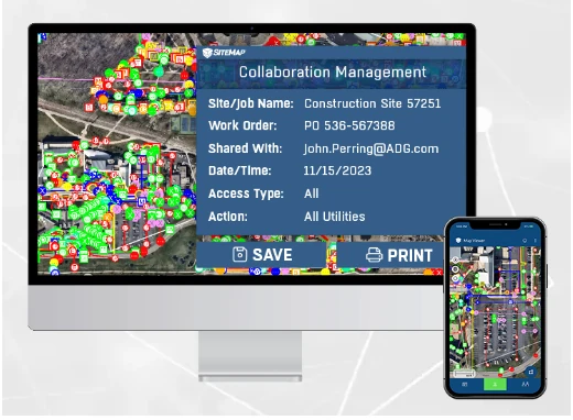
SiteMap®: GIS Platform and App
SiteMap® GIS Software gives GPRS customers control of your communications, workflows, record-keeping, and accountability. It provides a single source of truth capable of aggregating, tagging, geolocating, and layering existing subsurface and above-ground conditions to eliminate information bottlenecks, and reduce mistakes that lead to expensive clashes, change orders, reworks, and even serious injuries.
SiteMap® provides secure, 24/7 access to:
- Customized utility maps
- 2D CAD drawings
- 3D BIM models
- Point clouds
- Virtual tours
- NASSCO reports
All above and below ground data is stored, organized, and instantly shareable with your team.
Learn more about SiteMap GIS Platform.
Partner with GPRS for Safe, Accurate Project Planning
With GPRS as your partner, you gain the field verified data and expert support you need to eliminate guesswork, reduce risk, and keep your project on track. No matter the complexity of your site, we deliver the clarity needed to make safe, informed, compliant decisions, from planning through execution.