

.svg)
Many people rely on their smartphones to find directions, whether they're driving, walking, or exploring a new city. Most smartphones today come with GPS apps that show where you are on the map and provide turn by turn directions. This dynamic, personalized navigation has become second nature to most users.
To advance digital navigation, wayfinding software companies are leveraging reality capture technology to deliver real-time navigation through complex buildings and campuses, helping users orient themselves and move efficiently.
Reality capture provides accurate data for wayfinding, capturing accurate details of complex indoor and outdoor environments. It delivers digital representations of real-world spaces that can be used by software companies to develop intuitive and efficient navigation systems.
According to Conquest Creatives, “Good wayfinding systems significantly enhance the user experience by reducing stress, saving time, and ensuring safety. In complex environments like hospitals, airports, and campuses, effective wayfinding can be critical to the smooth operation of these spaces. It supports accessibility, ensuring that everyone, including those with disabilities, can navigate easily.”
What Is Wayfinding?
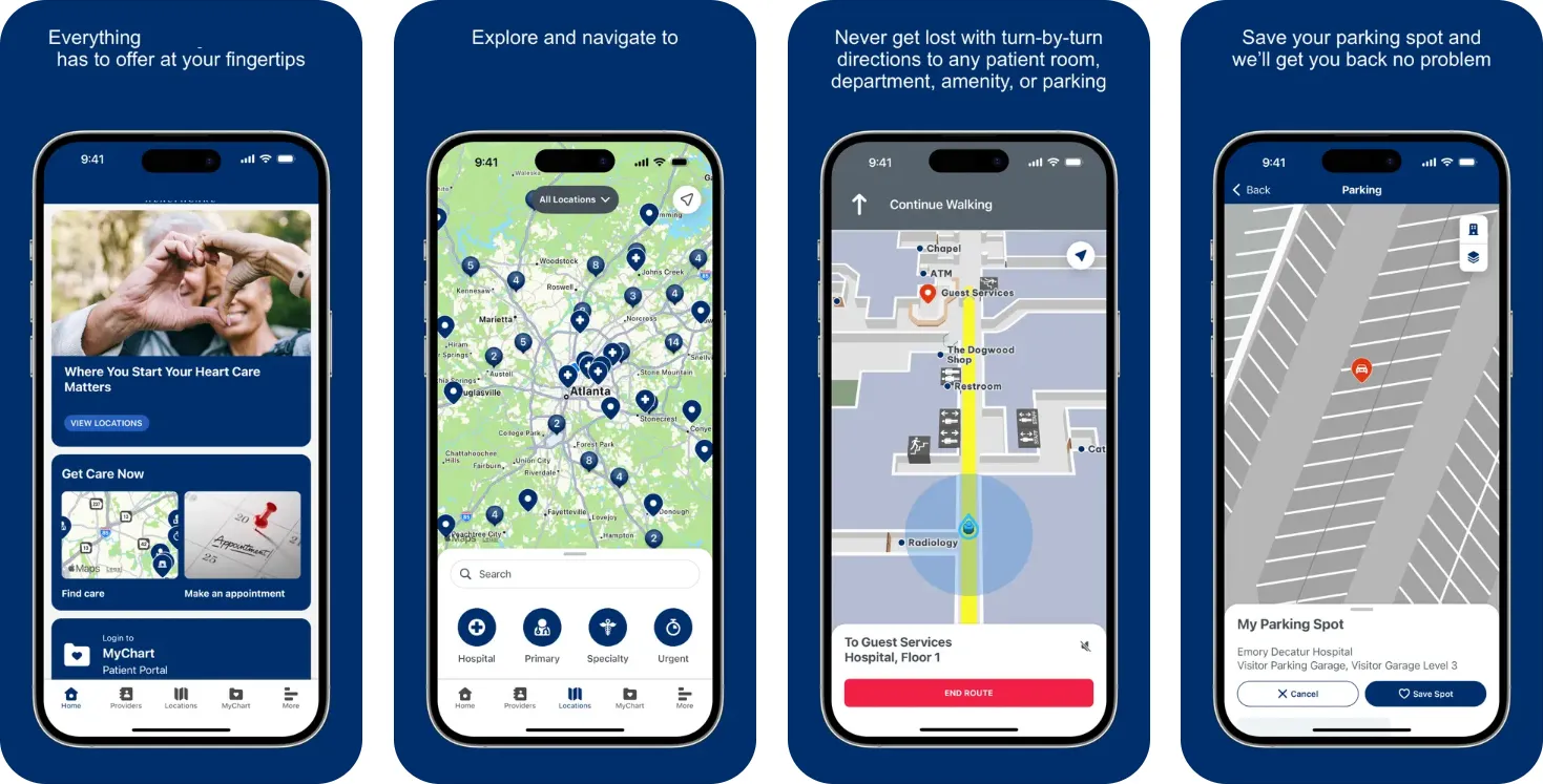
Wayfinding is the process of navigating a physical site and finding an optimal route to reach a destination, whether it be a specific room or building. Wayfinding technology provides real-time navigation through unfamiliar or intricate layouts across both indoor and outdoor environments.
Many companies are developing wayfinding platforms to help users reach their destination in complex spaces, such as hospitals, airports, shopping centers, and corporate campuses. Customized software and apps can be installed on a user’s smartphone and interactive kiosks on site.
These applications calculate routes between specific points or areas of interest and display them on interactive maps. When integrated with indoor positioning systems, they replicate the “blue dot” experience familiar from outdoor navigation tools like Google Maps. This allows users to locate themselves and navigate accurately without relying on GPS.
Vince Palko, GPRS Marketing Director, has spent many years in the digital geolocation realm, and has seen this evolution firsthand, “As digital interaction becomes more embedded in daily life, wayfinding apps have emerged as an innovative tool to help people navigate complex environments.”
Who Benefits from Wayfinding?
According to WaveTech, the key features of interactive wayfinding systems are designed to make navigating complex facilities more straightforward and efficient.
Wayfinding technology supports a wide range of users.
- Visitors who are unfamiliar with a location gain confidence and clarity in finding their way.
- Individuals with visual or hearing impairments can navigate more independently.
- Users speaking different languages can receive instructions in their preferred language to help navigate spaces.
- Emergency services can be assisted by providing real-time navigation and location tracking, enabling faster and more coordinated response efforts.
- In disaster planning, these tools help map evacuation routes, identify critical infrastructure, and visualize risk zones to enhance preparedness.
- By alerting users to hazards and guiding safe movement, wayfinding technology plays a key role in risk mitigation, including managing crowd flow to reduce congestion and panic.
Even those familiar with a location benefit from real-time information that improves efficiency and engagement, particularly in healthcare settings where it can strengthen patient loyalty and satisfaction.
According to UC Santa Cruz professor of Computer Science and Engineering Roberto Manduchi, "apps will enable blind people to navigate indoor buildings with spoken directions from a smartphone app, providing a safe method of wayfinding where GPS doesn’t work.”
Data Types Needed for Wayfinding Apps
Wayfinding apps provide precise step-by-step navigation using detailed 3D maps. They offer a complete navigation experience that begins at home, continues through parking, and ends at the destination. Routes can be tailored to meet individual needs, including accessibility requirements. Real-time updates and location-aware guidance reduce frustration and help prevent missed appointments by adjusting routes dynamically based on current conditions.
Wayfinding apps rely on a variety of data types to function effectively. Here's a breakdown of the key data types they typically need:
Spatial Data
- Floor plans and site maps to show accurate layouts of buildings and campuses
- 3D models using reality capture technology such as LiDAR and photogrammetry to create digital twins
- Geospatial coordinates to define locations and routes
Positioning Data
- GPS data to support outdoor navigation
- Indoor positioning systems to locate users with Bluetooth beacons, Wi-Fi signals, inertial measurement units, or magnetic field mapping
- Real-time location tracking to update user position dynamically
Routing & Navigation Data
- Pathways and connections to provide information on walkways, corridors, elevators, stairs, and ramps, etc.
- Accessibility features to support users with mobility challenges
- Points of interest to locate restrooms, guest services, entrances, and exits
Environmental & Operational Data
- Live updates on construction zones, temporary closures, and detours
- Traffic flow in busy environments like airports and hospitals
Visual & AR Data
- Augmented reality guidance onto real-world views
- Preview routes through 3D walkthroughs and visual simulations
How Reality Capture Technology Supports Wayfinding
Reality capture technologies such as 3D laser scanning and photogrammetry equipment captures detailed spatial data of a site, including the building’s exterior and interior floorplans, sidewalks, parking lots and garages, entrances and exits, accessibility features, stairways, and more. In addition to capturing this spatial data, the scanner captures positioning data, routing and navigation data, environmental and operational data, and visual and AR data.
Comprehensive site data is used to create a 3D BIM model and a unified site map, which can be integrated into mobile wayfinding apps to help users navigate the site easily.
These BIM models serve as digital twins, forming the foundation for precise navigation and route planning. In complex indoor settings like hospitals and airports, reality capture ensures that floor plans and spatial data reflect the actual layout.
This technology enables wayfinding apps to map both indoor and outdoor environments with precision, identifying features such as ramps, elevators, stairs, and obstacles. Augmented reality can be layered onto real-world imagery, guiding users visually and intuitively. Users can preview their routes in immersive 3D before beginning navigation, and the app remains reliable even in areas where GPS signals are unavailable.
GPRS Reality Capture Services for Wayfinding Companies
GPRS Reality Capture Services delivers the precise spatial data needed to power wayfinding apps and enable real-time AR navigation to help users confidently navigate complex indoor and outdoor environments.
We have Project Managers in every major U.S. market ready to quickly document accurate site data. Our Project Managers undergo an extensive SIM certification training program to ensure their competence in laser scanning equipment, field knowledge, and providing accurate data for every project.
Our Project Managers use state-of-the-art equipment to document existing site conditions. With Leica 3D laser scanners, we deliver data efficiently and with an accuracy of 2-4 mm and with the Matterport Pro3, updated with LiDAR-based scanning, we can deliver 20mm accuracy.
Scans are taken in multiple positions around a site from varying viewpoints. Millions of data points are captured and processed into a point cloud, creating an accurate 3D as-built data set of the site. This all happens very quickly, with some scanners, like our Leica RTC360, capturing and calculating 2 million points per second with 2-4 mm accuracy.
Reality capture data can be collected as environments change, helping to maintain the accuracy of wayfinding apps. Frequent scans detect layout modifications, construction zones, and temporary barriers, ensuring that navigation data will remain current. This information supports augmented reality solutions that overlay digital directions onto the user’s view of the physical space.
By integrating LiDAR data with GPS, inertial measurement units, and Bluetooth beacons, wayfinding apps achieve greater precision. GPS supports outdoor navigation, while IMUs and beacons provide reliable indoor positioning where GPS signals are weak or absent. These combined technologies allow for accurate turn-by-turn directions and identification of relevant points of interest.
Reality capture provides the essential data needed to build wayfinding apps that are accurate, dependable, and user-friendly across a variety of environments.
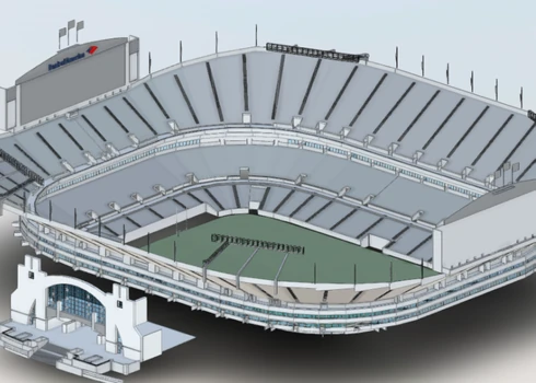
Case Study: Reality Capture of Six Hospital Parking Garages for Wayfinding
GPRS captured precise digital representations of six uniquely structured parking garages at a healthcare campus in Atlanta, enabling a software company to build a wayfinding app that improved navigation for patients and visitors. Read the full case study.

Problem:
- The hospital campus featured multiple parking structures with inconsistent layouts, some aboveground, some underground, and some interconnected across levels.
- Patients and visitors frequently experienced difficulty navigating from their vehicles to their medical offices, resulting in frustration, delays, and operational strain on staff.
- The total space reality captured was 1,681,500 SF and included the following parking garages within the scope of work:
- Green Parking Garage - 6 Levels - 510,000 SF
- Blue Parking Garage - 2 Levels - 160,500 SF
- Purple Parking Garage - 5 Levels - 222,500 SF
- Gold Parking Garage - 3 Levels - 271,000 SF
- North Employee Garage - 6 Levels - 285,000 SF
- South Employee Garage - 5 levels - 232,500 SF
Solution:
- Before reality capture began, the team conducted walkthroughs of each parking deck with the client to confirm the scope and develop scanning strategies tailored to the vast and complex layouts, ensuring no disruption to hospital operations.
- Over the course of just one week, a three-person GPRS team used the Matterport Pro 3 and Leica RTC360 laser scanners to capture every parking level, space, stairway, and hospital access point.
- Accurate reality capture data was used to create individual 3D BIM models for each parking garage and a unified campus model, which served as the foundation for generating 2D plans and immersive virtual tours.
- Deliverables were integrated by the software company into a mobile wayfinding app featuring AR capabilities and indoor positioning to guide users through the hospital campus with ease.
Benefits:
- Reality capture provided the spatial accuracy needed to power the app’s real-time AR navigation and location-saving features.
- The 3D BIM model formed the foundation for accurate routing, orientation, and destination mapping.
- Reality capture supported augmented reality (AR) overlays by aligning digital cues, like directional arrows or points of interest, with physical features in real-world spaces.
- Accurate wayfinding reduced staff reliance for wayfinding assistance and improved operational efficiency across the campus.
- Additionally, the CAD and BIM files can be used to support future upgrades and ongoing maintenance.

What Can GPRS Help You Visualize?
By delivering precise, real-time spatial data, reality capture empowers wayfinding software developers to build highly accurate navigation tools for complex indoor and outdoor environments. From hospitals and airports to campuses and commercial centers, these innovations enhance user experience, improve operational efficiency, and support inclusivity for all users.
GPRS Reality Capture Services provide the high-resolution 3D data that forms the foundation of these advanced wayfinding systems. In environments where accuracy is critical, GPRS helps ensure your navigation tools are dependable and up to date. Whether you're developing a mobile app or an interactive kiosk, our regularly updated scans and 3D BIM models make it easy to deliver seamless, user-friendly navigation experiences.
With GPRS, you gain a trusted partner in creating intelligently navigable spaces, powered by data you can rely on.
Contact GPRS today for more information on reality capture services for wayfinding companies, software, and apps.
Frequently Asked Questions
What is reality capture?
Reality capture is the process of digitally documenting physical environments using technologies like 3D laser scanning and photogrammetry. It produces accurate spatial data that can be used to create models, maps, and visualizations for design, construction, and asset management.
Why is reality capture better than traditional mapping methods for wayfinding?
Traditional mapping often lacks the spatial detail and real-time adaptability needed for indoor or multi-level navigation. Reality capture provides centimeter-level accuracy and enables features like AR navigation, indoor positioning, and dynamic route updates. This leads to smoother user experiences, reduced confusion, and better operational efficiency in places like hospitals or event venues.