

.svg)
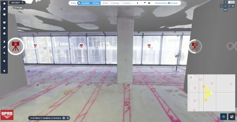
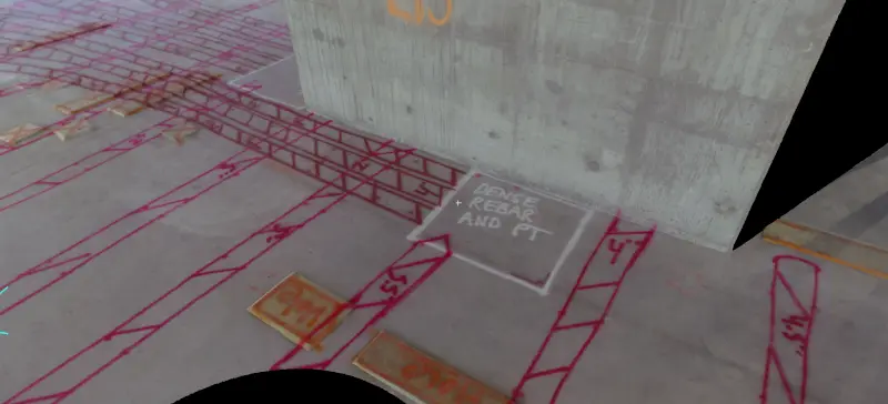
A 3D laser scanner captures concrete markings by emitting laser beams that reflect off surfaces and return to the scanner, collecting millions of precise data points that map the concrete markings on site. These data points are compiled into a high-resolution 3D point cloud that maps the shape, texture, and position of everything in view, including paint, chalk lines, or other surface markings. This digital record allows teams to document site conditions, verify layouts, and permanently record markings for future reference.
Not only does the 3D laser scanner provide detailed and accurate records of concrete markings, but it also captures all architectural, structural and MEP features, delivering a comprehensive digital asset for renovation, construction, and analysis.
What is the Method of Concrete Scanning?
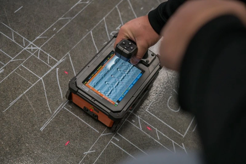
Concrete scanning uses ground penetrating radar (GPR), which sends radio signals into the concrete to detect subsurface features. The system’s transmitter, receiver, and signal processor work together to identify embedded objects like rebar, conduits, or post tension cables. Trained professionals interpret the reflected signals to map their location, pattern, and depth.
What is the Process of Capturing Concrete Markings with a 3D Laser Scanner?
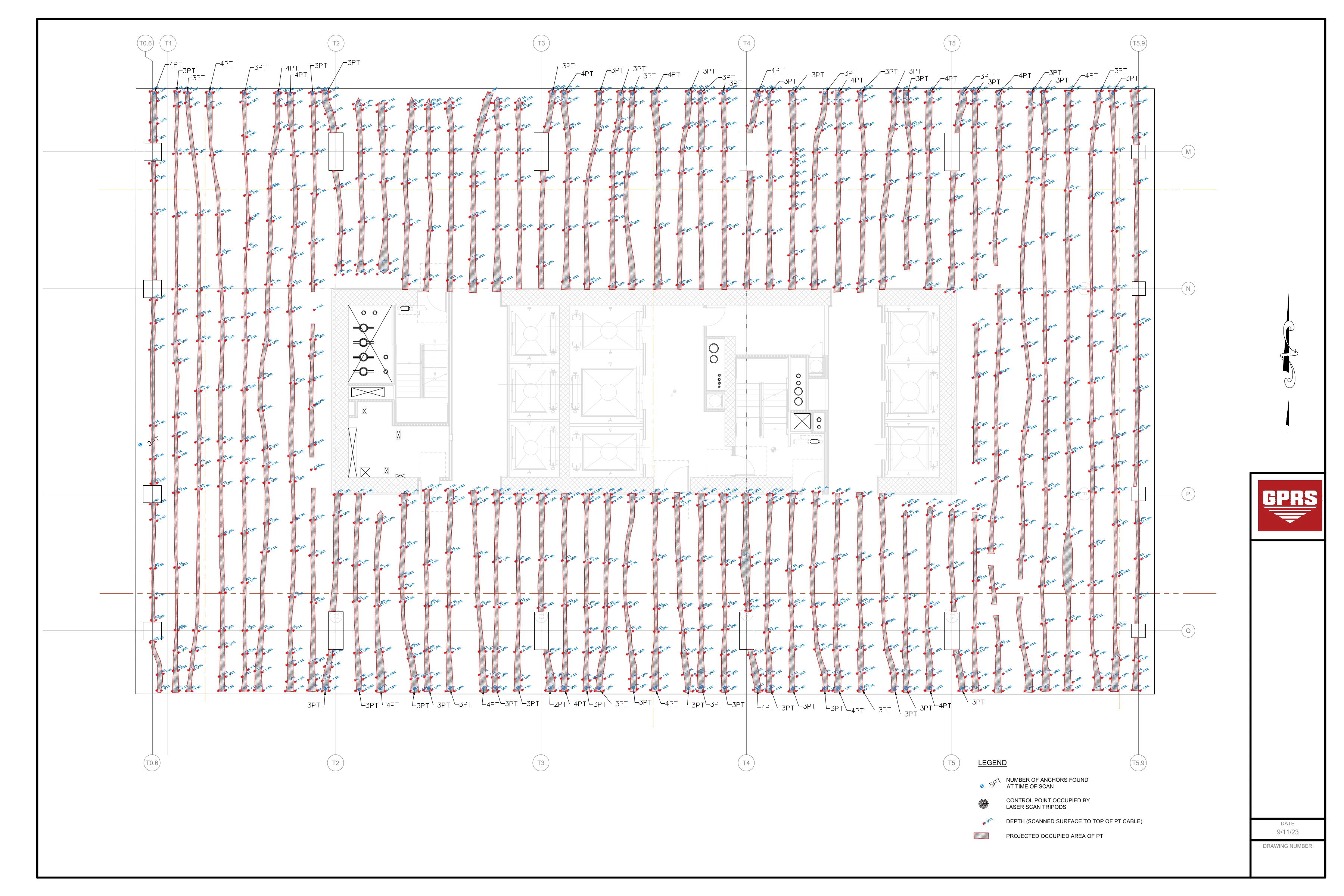
- Process: After using GPR to identify and mark objects within concrete, such as rebar or utilities, a 3D laser scanner captures these markings in a point cloud.
- Purpose: This process allows for accurate documentation of concrete markings and can be used to generate 2D CAD drawings or 3D models of findings to aid in safe cutting, drilling, or anchoring into concrete.
- Technology: Leica laser scanners, such as the RTC360, utilize LiDAR technology to capture precise site data at high speeds.
- Software: Leica Cyclone or Autodesk Recap can be used to process the captured point cloud, allowing for the extraction of markings and the generation of CAD/BIM deliverables.
- Benefits: Capturing concrete markings with laser scanners like the Leica RTC360 ensures 2-4mm accuracy and helps minimize human error, leading to improved safety and efficiency on construction sites.
Why Use Leica Laser Scanners to Capture Concrete Markings?
Leica laser scanners are considered among the best in the industry because they combine exceptional speed, accuracy, and ease of use with powerful software integration. For example, the Leica RTC360 laser scanner can capture up to 2 million data points per second and uses advanced features like automatic point cloud registration and HDR imaging to deliver high-quality, colorized scans in under two minutes. Leica’s software makes it easy to turn raw scan data into deliverables like BIM models, CAD drawings, and immersive 3D environments. High-resolution imagery, or TruViews, can be added to the laser scanning process, making it easier to identify and document markings digitally for layout verification or future reference.
Can GPRS Use a 3D Laser Scanner to Capture Concrete Markings?
Yes, the Project Managers at GPRS are formerly trained to perform concrete imaging services using GPR technology and reality capture services using 3D laser scanners.
GPRS Project Managers complete the most extensive subsurface training program in the industry, called SIM certification. SIM teaches Project Managers how to utilize GPR and EM locating to identify the layout of rebar, post tension cables, buried utilities, and more with 99.8%+ accuracy. Achieving SIM 101 certification, which is required of all GPRS Project Managers, involves completing 80 hours of hands-on classroom instruction and 320 hours of mentorship in the field.
While the technology for underground utility locating and concrete imaging is standardized, the methods of deploying the tools are not. SIM certification ensures the precision and attention to detail necessary for the accurate subsurface investigations that will keep projects on time, on budget, and safe.
The training program for GPRS 3D laser scanning services includes an additional 40 hours of LiDAR training on Leica scanning equipment, plus additional field experience.
GPRS Project Managers have elite training in concrete scanning and reality capture technologies, plus a field-tested methodology to deliver high-quality results tailored to each project’s needs.
GPRS Intelligently Visualizes the Built World® above and below ground as the leading national provider of accurate utility locating, concrete scanning & imaging, reality capture, video pipe inspection, leak detection, and mapping & modeling solutions for the construction, architecture, and engineering industries.
What can we help you visualize?
Frequently Asked Questions
What Types of Concrete Scanning are There?
GPRS provides two specific but different concrete scanning services: elevated concrete slab scanning and concrete slab-on-grade locating. Elevated concrete slab scanning involves detecting embedded electrical conduits, rebar, post-tension cables, and more before core drilling a hole through the slab. Performing a concrete slab-on-grade locating service typically involves scanning a trench line for conduits before conducting saw cutting and trenching to install a sanitary pipe, water line, or something similar.
Who Needs Concrete Scanning?
Clients turn to us for concrete scanning for a range of needs, from verifying the placement of rebar to safely drilling or cutting into post-tension slabs without damaging the tensioned cables.