

.svg)
GPRS Project Manager Aaron Bradley followed the guidelines of Subsurface Investigation Methodology (SIM) to help a large plant safely install electrical conduit and avoid utility strikes.

The client had plans to add new electrical conduit across their facility. The areas that the client planned to add the utilities covered a vast majority of the plant and totaled over four acres of land. Because Bradley had worked with this client before, they felt comfortable trusting GPRS with such a large and important project.
“I've done a couple of smaller locates there. Then they decided to do this huge locate and because there's going to be such a large section of it completed, they decided to go with us,” Bradley said.
The client had no current or accurate as-built records of their underground utilities, so they would have been digging blind or doing lots of unnecessary potholing without the results Bradley gathered.
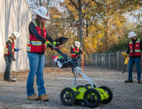
Bradley used both ground penetrating radar (GPR) and electromagnetic (EM) locators to scan, document, and assess the utilities located in the requested areas. Bradley’s use of multiple complementary technologies follows directly along with one of the three main teachings of Subsurface Investigation Methodology (SIM), the backbone of GPRS’ continuous 99.8% accuracy as a national utility locating company.
Subsurface Investigation Methodology is a standard operating procedure and set of professional specifications that work as a guide for utility locating experts when scanning for buried utility lines. All GPRS Project Managers are required to achieve SIM 101 certification, which requires 80 hours of hands-on training in a classroom setting and 320 hours of mentorship in the field. For reference, the American Society for Nondestructive Testing’s (ASNT) minimum training recommendation includes eight hours for training and 60 hours practicing GPR to achieve NDT Level 1 certification in ground penetrating radar (GPR) scanning.
SIM requires the use of multiple, complementary technologies, like GPR scanning and EM locating, when locating buried utilities or scanning a concrete slab.
While this wasn’t the largest scan Bradley had ever performed, he was surprised at the volume and density of underground utilities at the facility.
“There were so many electrical lines and random gas lines, that you wouldn't expect,” Bradley explained. “[The site also had] unknown pipes that hook up to it in one building and it somehow shoots all the way across the scan area going who knows where. There was just a lot of stuff going in every which way direction.”
Bradley marked out each utility using spray paint and flags. Once the scans were completed, the utility map was uploaded and securely sent to the client via SiteMap® (patent pending), GPRS’ digital infrastructure mapping software. With SiteMap, the field-verified and RTK positioned data is always at their fingertips allowing them to reference the results at every step of the project. Their utility map can even be in the palm of their hand on their mobile devices or tablets by using the SiteMap mobile app.

Due to the number of utilities in these areas, without GPRS’ 99.8% accurate scans and SiteMap, the chances of a utility strike would have been very high. Such a strike could have completely derailed the project.
The client communicated to Bradley their satisfaction with the results and data he presented.
“They were definitely happy with me because I got everything done and it all got to them when they needed it,” Bradley explained.
Following the initial scans of the area, Bradley has continued to help with this project.
“[The site contact and I] talk pretty regularly about the job,” Bradley said. “I've gone back there a few extra times just to re-mark some areas because it's so massive, they're doing all this demo, and the marks go away once they tear up the ground.”
While SiteMap retains all GPRS’ geolocated data, GPRS highly recommends having our Project Managers verify utility locations before digging. Potential soil shifts and increases in trenchless technology utility installations mean that every precaution should be taken before breaking ground.
The Purpose of Utility Locating and Mapping
Based on the Common Ground Alliance’s (CGA) DIRT Report, as much as 94% of reported utility strikes are attributed to inaccurate or missing utility location data and they have seen little movement in those figures in the last five years. Because of this, utility maps are very important.
The purpose of a utility map is to provide a comprehensive record of the subsurface infrastructure of a facility or any property, so any necessary excavation can be completed safely and maintenance or repairs can be planned more efficiently. GPRS highly recommends utility mapping as part of a general contractor or excavator’s ground disturbance policy. In fact, we offer complimentary dig policy reviews based on Subsurface Investigation Methodology.
There are four steps you should take to make sure you’ve properly assessed a job site before digging:
- Call your local 811 service
- Hire a Professional Private Utility Locator
- Update your Ground Disturbance Policy to Require Public & Private Utility Locating Before Excavation
- Utilize a Secure, Sharable Underground Utility Mapping Platform
GPRS is in pursuit of 100% subsurface damage prevention. With 99.8% accurate scans, SIM-certified Project Managers, and SiteMap, clients can dig with confidence knowing the chance of a utility strike has significantly reduced.
Whether your project is four acres or forty stories, GPRS Intelligently Visualizes the Built World® to keep your projects on time, on budget and safe.
What can we help you visualize?
FREQUENTLY ASKED QUESTIONS
Can GPRS Project Managers distinguish between the different utilities they locate?
In most situations, we can identify the utility in question without any problems, although it is not always possible to determine what type of utility is present. When this happens, we attempt to trace the utility to a valve, meter, control box, or other signifying markers to determine the type of utility buried.
How does SiteMap® assist with Utility Mapping?
SiteMap, powered by GPRS, is the industry-leading infrastructure management program. It is a single source of truth, housing the 99.8%+ accurate utility locating, concrete scanning, video pipe inspection, leak detection, and 3D laser scanning data our Project Managers collect on your job site. And the best part is you get a complimentary SiteMap Personal access when GPRS performs a utility locate for you.