

.svg)
When one of America’s most prestigious universities was planning to renovate their advanced medical research facility, they relied on reality capture data and deliverables from GPRS to help them start accurate and stay accurate.
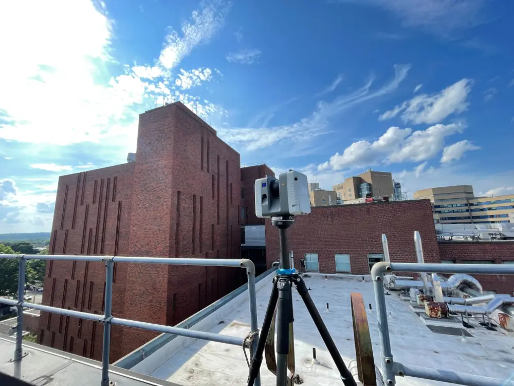
A team of GPRS Project Managers 3D laser scanned every inch of the six-story building, including the exterior façade, to capture the accurate existing conditions documentation the university required.
Accurate, real-time as-built data is essential for informed decision-making and seamless collaboration. With precise design plans from the start, architects, contractors, engineers, and facility managers can streamline fieldwork and minimize change orders, plus avoid delays and extra costs.
GPRS Reality Capture Services provide clients with precise as-built documentation of buildings and infrastructure using advanced Leica laser scanners, delivering point clouds, 2D CAD drawings, and 3D BIM models to streamline project planning and construction.
At the university, the GPRS team had to conduct its scans after hours, so as not to disrupt the research being conducted in the facility and so that medical equipment such as MRI machines could be turned off and not interfere with the 3D laser scanning equipment.
“They wanted us in there with as few people as possible, so we’re not disturbing anything,” said GPRS Sales Development Representative John Lehaney, who was a Project Manager on the assignment. “Essentially, we were in there to document everything in sight that they were looking to renovate. They had no existing floor plans.”
GPRS deployed the Leica RTC360, and NavVis VLX 3D laser scanners to capture 2-4 mm accurate data of the research facility.
The Leica RTC360 3D laser scanner combines a high-performance laser scanner with Cyclone FIELD 360, a mobile-device app on a tablet computer, to capture and automatically pre-register scans in real time. With a measuring rate of up to 2 million data points per second and advanced HDR imaging system, you can have 3D colorized point clouds with 2-6 mm accuracy in under 2 minutes. Automatic targetless field registration (based on VIS technology) and the seamless transfer of data from site to office reduces time spent in the field, maximizing project productivity.
The NavVis VLX captures survey-grade point clouds with two multi-layer LiDAR sensors equipped with SLAM (simultaneous localization and mapping) technology. Four cameras are positioned on top of the device, taking high resolution images in every direction for complete 360º capture – all without the operator appearing in the field of view.
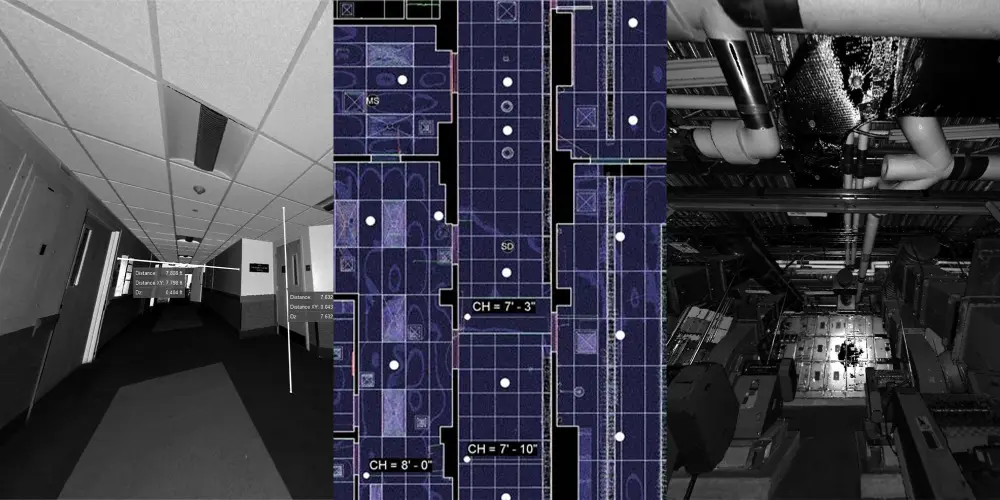
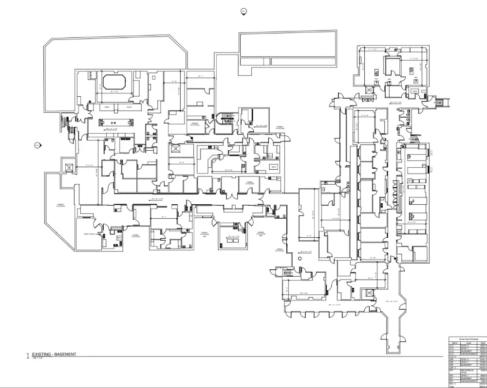
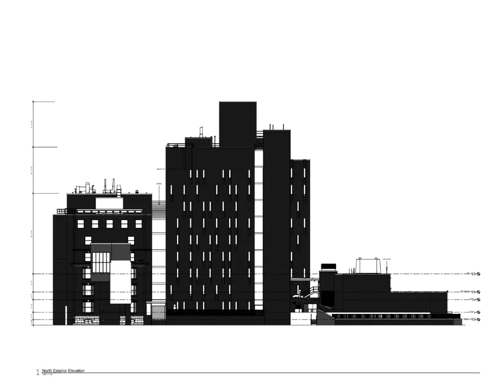
With the RTC360 and NavVis, Lehaney and his fellow Project Managers were able to collect the data needed for GPRS’ in-house Mapping & Modeling Team to create a 3D Revit model, floor plans, a roof plan, a TruView Virtual Site Visit, exterior elevations, and reflected ceiling plans (RCPs) to assist the university in accurate design and planning for their renovations.
The university had the accurate data they needed, and it was obtained without disrupting the vital research being conducted in the facility.
From visualizing school campuses to locating buried utilities and beyond, GPRS Intelligently Visualizes The Built World® to keep your projects on time, on budget, and safe.
What can we help you visualize?
Frequently Asked Questions
How do I know if 3D laser scanning is right for my project?
Almost any project that requires as-built information can benefit from a laser scanning survey. Talk with our experts and start your 3D laser scanning survey project today.
What deliverables can GPRS provide?
We can provide 3D modeling in many formats such as:
- Point Cloud Data (Raw Data)
- 2D CAD Drawings
- 3D Non-Intelligent Models
- 3D BIM Models
- JetStream Viewer
Customizable Deliverables Upon Request
- Aerial Photogrammetry
- Comparative Analysis
- Deformation Analysis
- Digital Drawings of GPR Markings
- Floor Flatness Analysis/Contour Mapping
- New Construction Accuracy Analysis/Comparative Analysis
- Point Cloud Modeling Training Webinars
- Reconciliation of Clients 2D Design Drawings
- Reconciliation of Clients 3D Design Model
- Structural Steel Shape Probability Analysis
- Template Modeling
- Volume Calculations
- Wall Plumb Analysis