

.svg)
GPRS’ visualization services provided a gas station with an above and below-ground view of the store’s existing conditions to ensure the safety and success of a remodeling project.
The client was planning to remodel the gas station’s interior store area. However, they did not have any accurate as-built documentation for the property. Without accurate plans, the chance of a utility strike is very high when remodeling.
Gas stations have a very extensive and complex network of underground utilities. Underground storage tanks (USTs), fuel piping, and electrical conduit are all needed to keep gas stations operational. Striking any of these underground utilities could cause delays, temporarily closing the gas station for repairs, and severe injuries to workers or patrons.
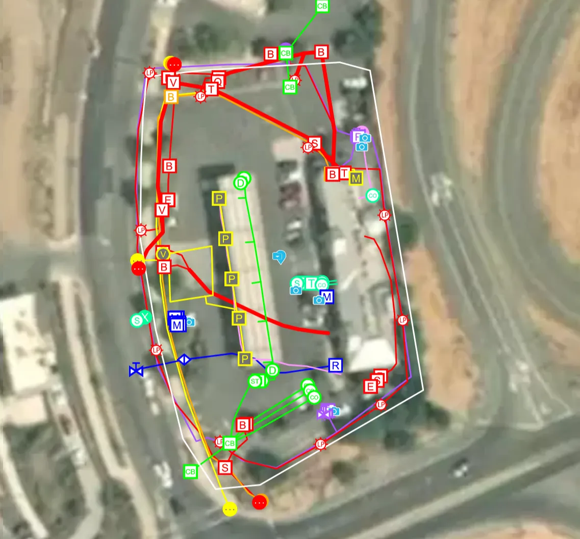
GPRS Project Manager Jeffrey Paneda performed 99.8% accurate utility and concrete scans across the whole property and reality capture scans in the store’s interior.
.webp)
The store had to remain open during the scanning process. Even though Paneda worked around high traffic areas, he used constant communication and wore his proper PPE to ensure that the scans and the gas station’s business would not be affected.
“With it being an operational store, it definitely was a challenge, so to overcome it, I was communicating with the store manager and the employees, making sure they know why I'm there,” Paneda explained. “With the people that don't know what I'm doing out there, I have high vis [high-visibility clothing] on and so that definitely shows, ‘Hey, I'm here working.’”
Along with the constant flow of people in Paneda’s scan paths, there was also a nearby freeway that needed to be investigated.
“[The gas station] was up against a freeway, so trying to see all the utilities around the outside coming in was a bit of a challenge, because, obviously there’s high amounts of cars speeding by,” Paneda explained. “It's a little bit more challenging, but I still made sure I didn't miss anything.”
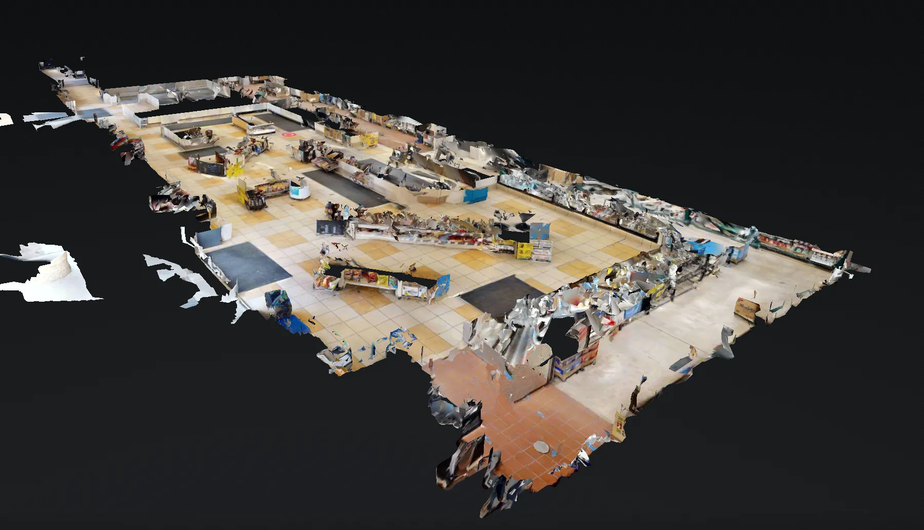
During his time on site, Paneda also performed reality capture scans of the store’s interior to capture virtual measurements with millimeter accuracy. Paneda took approximately three days to scan the entire site.
Once Paneda completed the scans, he uploaded the results into SiteMap® (patent-pending), GPRS’ cloud-based infrastructure platform. With SiteMap, the client’s data is securely stored in one place. And with the SiteMap mobile app, they always have their underground infrastructure is always in their pocket or the palm of their hand, ready to analyzed.
GPRS’ in-house Mapping & Modeling Team then converted the reality capture data into 2D drawings and 3D models of the store’s interior. These deliverables included 2D CAD drawings and an immersive virtual model of their store.
With this data at their disposal, they could efficiently plan and confidently dig as they remodeled the store’s interior. By avoiding any rework or delays associated with utility strikes, their project could remain on time, on budget, and safe.
While out on another job, Paneda saw that gas station and noticed that they had completed the remodeling process.
“I see the renovations they made, and it looks much better,” Paneda explained. “Coming back and seeing our hand in helping them out was really cool.”
From skyscrapers to sewer lines, GPRS Visualizes the Built World by showing clients what they need to see.
What can we help you visualize?
FREQUENTLY ASKED QUESTIONS
What do I get when I hire GPRS to conduct a utility locate?
Our Project Managers flag and paint our findings directly on the surface. This method of communication is the most accurate form of marking when excavation is expected to commence within a few days of service. If we can not leave markings with paint, we have other ways of marking out sites that meet our clients’ needs.
GPRS also uses a global positioning system (GPS) to collect data points of findings. We use this data to generate a plan, KMZ file, satellite overlay, or CAD file to permanently preserve results for future use. GPRS does not provide land surveying services. If you need land surveying services, please contact a professional land surveyor.
Please contact us to discuss the pricing and marking options your project may require.
Can GPRS Project Managers distinguish between different underground utilities that they locate?
In most situations, we can identify the utility in question without any problems, although it is not always possible to determine what type of utility is present. When this happens, we attempt to trace the utility to a valve, meter, control box, or other signifying markers to determine the type of utility buried.
What are the Benefits of Underground Utility Mapping?
Having an updated and accurate map of your subsurface infrastructure reduces accidents, budget overruns, change orders, and project downtime caused by dangerous and costly subsurface damage.