

.svg)
The empty areas underneath slab-on-grade concrete and/or pockets of air within concrete slabs are known as voids. They can form due to soil erosion, poor installation or compaction, animals digging, or trapped air.
Concrete voids can lead to significant damage. Unaddressed concrete voids lead to reduced load-bearing capacity, safety hazards as the concrete shifts and sinks, water damage and leaks, or complete structural failure.
The High Point Reserve apartment complex in Austin, Texas was experiencing signs of concrete voids. They noticed their foundation was sagging and water was leaking.
The complex took immediate action and hired the general contractors the Journeyman Group to address the problem. The GCs then tasked GPRS Senior Project Manager Daniel Reis with scanning the concrete slabs to identify any potential voids.

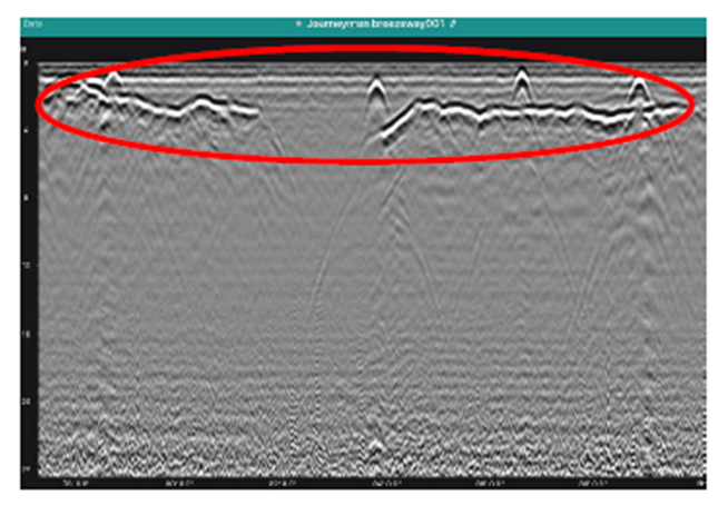
When scanning concrete slabs, GPRS PMs utilize ground penetrating radar (GPR). They analyze the results with an expertly trained eye to map out any conduit, rebar, post tension cables, or, in this case, potential voids.
Since 2017, our Project Managers have maintained a <0.2% at-fault incident rate on concrete scanning jobs, so Journeyman and the stakeholders could rely on Reis’ results.
When he was first called to the site, the scope of work was scanning a walkway running some of the units. Based on what his scans were showing him, he believed there was a larger issue at play.
“Originally, the job was scheduled for a half day and the note section said that they were hoping we could identify potential voids,” Reis explained. “They had just a couple of areas of concern that they wanted me to check out. When I got toward their area of concern, it made me concerned. I saw the data and I told the client, “I can definitely see through the slab - this area is concerning.’”
After scanning other areas of concern over the next hour and talking with Area Manager Ryan Dennis about the situation, Reis went back to the client to deliver his initial findings and gather more information on the site.
“I then talked to the on-site contact and found out that they had quite a few more areas that were concerning to them,” Reis explained. “So, I gave them my business card and I said, ‘Whenever you're ready to get these scanned, we’ll get you guys on my schedule.’ And the on-site client said, ‘Yeah, let's go ahead and do that.’”
The scope of work expanded from a half day to multiple trips over two weeks. Reis scanned rooms predominately on the first floor and other breezeways in multiple buildings during his visits.
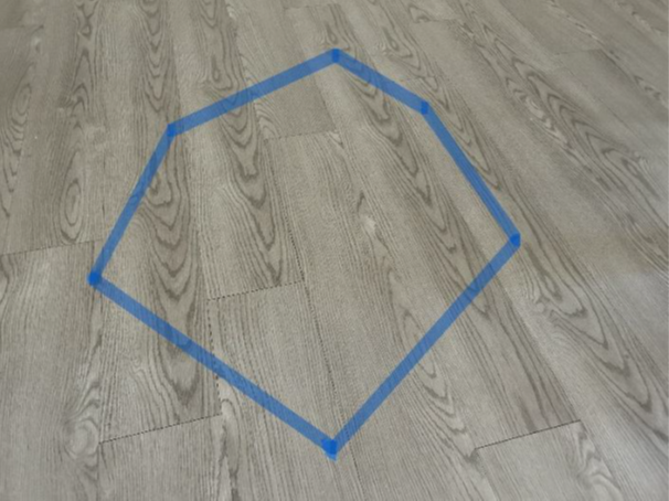
Since the apartment complex had current residents, the owners didn’t want Reis’ findings marked with spray paint or chalk to avoid potential panic about the condition of the tenants’ homes. Seeing random red or black markings on your living room or kitchen floor certainly would raise some eyebrows. Reis instead marked the areas with potential voids using tape that was easily removable once they took photos and talked with the site contact.
Each time Reis conducted scans at the complex, he presented the Journeyman Group with a formal report along with the typical Job Summary Report (JSR). Every job conducted by GPRS features a JSR, which is exactly that – a summary of the job for the client to reference. A formal report gives the client a more in-depth report on our PM's findings in specific areas that includes GPR data screen shots, photos, and a map of our findings.
It is important to note that GPRS’ non-destructive concrete scanning methods can only identify potential voids, as verifying a concrete void requires additional destructive testing practices like concrete coring.
Reis' contact with the Journeyman Group has since reached out to let him know his scans have been very helpful in the planning process. They have also asked him to come back and scan the remaining buildings to ensure they have complete visualization of the site.
If your site is experiencing signs of concrete voids, don’t wait until it gets worse. Our team of concrete scanning professionals is happy to help identify where potential voids may be hiding.
FREQUENTLY ASKED QUESTIONS
How does ground penetrating radar detect potential voids?
When using GPR to investigate concrete, the device sends radio signals into the slab and reads the “bounces” when the wave encounters an object. These bounces appear as hyperbolas that our expertly trained Project Managers can read like a book.
From a potential void to a PT cable, each one has its own signal pattern that PMs use to decipher what is within the concrete slab. Schedule concrete scanning services here.
Can GPR determine the difference between rebar and electrical conduit?
Ground penetrating radar (GPR) can accurately differentiate between rebar and electrical conduit in most cases. We have an extremely high success rate in identifying electrical lines in supported slabs or slabs-on-grade before saw cutting or core drilling.
Additionally, GPRS can use electromagnetic (EM) locators to determine the location of conduits in the concrete. If we can transmit a signal onto the metal conduit, we can locate it with pinpoint accuracy. We can also find the conduit passively if a live electrical current runs through it.
The combined use of GPR and EM locating allows us to provide industry-leading conduit locating services. Schedule concrete scanning services here.
How are concrete scanning results from GPRS marked on site?
GPRS Project Managers use anything from spray paint, chalk, markers, and tape to mark their findings on concrete slabs. They also can mark their findings on temporary floor protection boards that are placed on top of the slabs to ensure they don’t leave markings in public, high-traffic spaces.
There is not a color code when identifying concrete obstructions like post tension cables, rebar, or conduit. So, we created one: the Green Box Guarantee. When a GPRS Project Manager marks a section of concrete with a green box, that means it is clear of obstructions.
Schedule concrete scanning services here.
What is SIM?
Subsurface Investigation Methodology (SIM) is a standard operating procedure and set of professional specifications that work as a guide for utility locating experts when scanning for buried utility lines. All GPRS Project Managers are required to achieve SIM 101 certification, which requires 80 hours of hands-on training in a classroom setting and 320 hours of mentorship in the field. For reference, the American Society for Nondestructive Testing’s (ASNT) minimum training recommendation includes eight hours for training and 60 hours practicing GPR to achieve NDT Level 1 certification in ground penetrating radar (GPR) scanning.
SIM requires the use of multiple, complementary technologies, like GPR scanning and electromagnetic (EM) locating, when locating buried utilities or scanning a concrete slab.